MUNICIPAL WASTE PRODUCTION
Data aggiornamento scheda: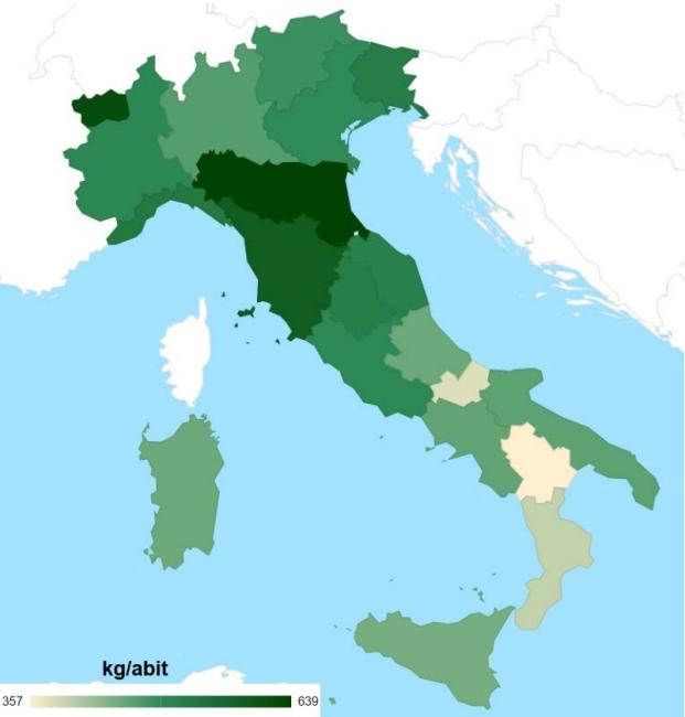
National municipal waste (MW) generation in 2023 amounts to approximately 29.3 million tonnes, marking a 0.7% increase (approximately +218,000 tonnes) compared to 2022.
NATURA 2000 NETWORK
Data aggiornamento scheda:The Natura 2000 Network in Italy consists of 2,646 sites, covering a total area, net of overlaps, of 5,845,078 hectares on land, equivalent to 19.4% of the national territory, and 2,301,047 hectares at sea, corresponding to 6.4% of territorial waters (data updated to December 2023). A total of 643 Special Protection Areas (SPAs) and 2,364 Sites of Community Importance-Special Areas of Conservation (SCI-SACs) have been designated (of which 361 are SCI-SACs coinciding with SPAs). In December 2022, the sites numbered 2,639, with an increase of 7 units in the past year and an expansion of 163 hectares on land and 229,358 hectares at sea. The coverage percentages of the Natura 2000 Network vary across Italian regions and autonomous provinces, ranging from 12% to 36% on land and from less than 1% to 30% at sea.
The national coverage of the Network is significant in relation to the targets of the EU Biodiversity Strategy for 2030 (SEB2030), which calls for expanding protected areas in the EU to reach at least 30% of terrestrial and 30% of marine areas. The SEB2030 target includes all areas subject to protection measures, such as Natura 2000 sites, National and Regional Parks, and other protected areas. At the regional level, Abruzzo and Valle d’Aosta meet the SEB2030 target, with Natura 2000 sites covering 36% and 30% of their territories, respectively. Other regions approaching the target include the Autonomous Province of Trento (28%), Molise (27%), Campania (27%), and Liguria (26%). The protection percentages of Natura 2000 marine sites are lower, with only Puglia (30%) and Tuscany (27%) having protection levels close to the target.
QUANTITY OF MUNICIPAL WASTE DISPOSED OF IN LANDFILLS AND NUMBER OF LANDFILLS
Data aggiornamento scheda:In 2023, the total amount of municipal waste disposed of in landfills amounted to approximately 4.6 million tonnes, with 112 landfill facilities in operation nationwide. Compared to 2022, this represents a 10.8% reduction in the total quantity of municipal waste landfilled (equivalent to -559,000 tonnes) and a 4.3% decrease in the number of operational sites (-5 facilities).
SHARE OF THE VEHICLE FLEET COMPLIANT WITH SPECIFIC EMISSION STANDARDS
Data aggiornamento scheda:This indicator tracks the share of road vehicles complying with the most recent emission standards during the 2005-2022 period. In 2022, passenger cars still showed a non-negligible proportion (13.7%) of Euro 0 gasoline vehicles, while for diesel cars this share was significantly lower at approximately 2.9%. More concerning is the commercial vehicle fleet situation - predominantly diesel-powered - where 11.2% of light commercial vehicles (vans) and 27.1% of heavy goods vehicles remain at Euro 0 standard.
WATER QUALITY – PESTICIDE POLLUTION
Data aggiornamento scheda: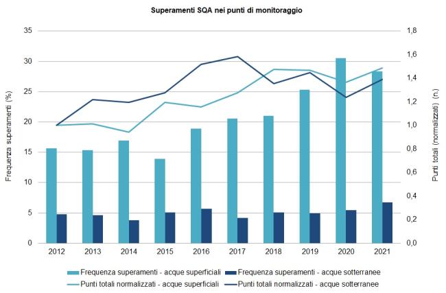
The indicator allows for the assessment of surface and groundwater contamination by pesticide residues released into the environment. Monitoring pesticide presence in water is complex due to the number of substances involved and their diffuse use. Measured levels are compared with the concentration limits established by current regulations. The presented indicators provide an analysis of the evolution of contamination over the 2012–2021 decade, in terms of the frequency of pesticide detection in water, as well as the environmental risks arising from their use. Data from 2021 confirm a state of contamination already reported in previous years, with exceedances of legal limits particularly in surface waters (28.3% of monitoring points); in groundwater, 6.8% of points exceed regulatory limits.
CIRCULAR MATERIAL USE RATE
Data aggiornamento scheda:The circular material use rate measures the share of material resources reused by an economy. In the period 2004–2022, Italy's circular material use rate increased from 5.8% to 18.7%.
COASTAL MARINE WATERS – BIOLOGICAL QUALITY ELEMENT CHLOROPHYLL a
Data aggiornamento scheda:The "chlorophyll" parameter is the only direct indicator of phytoplankton biomass available and has taken on the role of a metric for classifying ecological status according to the Biological Quality Element (BQE) – Phytoplankton in coastal waters (Ministerial Decree 260/2010). Chlorophyll is particularly sensitive to changes in trophic levels determined by nutrient (N and P) inputs from catchment basins flowing into the coastal area.
In 2020, high status was recorded in 71.4% of cases, good status in 12.3%, and sufficient status in 16.2%. A general improvement in status was observed in Campania and Marche, while Emilia-Romagna and Sardinia saw a worsening. Marche, Liguria, and Abruzzo maintained all stations at high status.
CONSERVATION STATUS OF SPECIES UNDER THE HABITATS DIRECTIVE 92/43/EEC
Data aggiornamento scheda: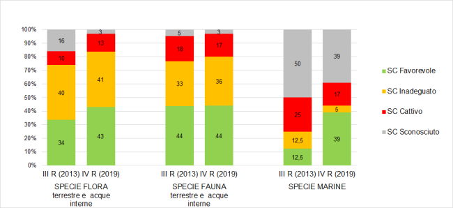
The indicator illustrates the conservation status and trends of Italian species protected under Directive 92/43/EEC (Habitats Directive) and is based on the summary results of the 4th Italian report for the period 2013-2018, submitted to the European Commission in 2019. The report covers a total of 349 species (232 animal species and 117 plant species) of Community interest present in our territory and seas. In the 4th report, a total of 337 distribution maps and 619 reporting forms were produced (one for each species in every biogeographical region where it is present). The 2019 assessments show that over half of the terrestrial and inland water species, 54% of the flora, and 53% of the fauna, as well as 22% of the species evaluated in the marine context, have an unfavourable conservation status (inadequate or poor). A comparison between the two most recent reporting periods (2007-2012 and 2013-2018) reveals no improvements in the conservation status of the species. The only positive signal is the increase in knowledge, with a decrease in cases where the conservation status was unknown. The indicator highlights the urgent need for greater commitment to the conservation of species protected by the Habitats Directive, in relation to the target of the European Biodiversity Strategy to 2030, which sets out that at least 30% of species and habitats in unfavourable conservation status should improve their status by 2030 or show at least a trend of improvement.
CONSERVATION STATUS OF TERRESTRIAL HABITATS UNDER DIRECTIVE 92/43/EEC
Data aggiornamento scheda:
The Habitats Directive (92/43/EEC) is one of the main pillars of the European Union's nature conservation policy. This indicator is based on data provided by Italy for the periodic reporting required of Member States under Article 17 of the Directive. The report provides a general summary of the Italy’s Fourth Report, referring to data from monitoring activities conducted by regions and autonomous provinces during the 2013–2018 period. Specifically, it highlights the overall conservation status observed for terrestrial and inland water habitats across the national territory, as well asthe distribution of conservation status across the Italian biogeographical regions. Additionally, the report outlines the number of assessments to be conducted by individual regions and autonomous provinces for habitat monitoring, providing an estimate of the expected workload.
The trend compared to the previous reporting cycle is negative, showing a decrease in favorable assessments. Currently, only 8% of cases are classified as having a favorable conservation status, while 49% are deemed inadequate and 40% poor. This indicates a generally critical situation, further distancing Italy from achieving the objectives set by the Directive.
ECOLOGICAL STATUS OF INLAND SURFACE WATERS
Data aggiornamento scheda: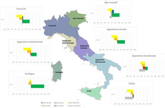
The ecological status of surface waters reflects the quality of the structure and functioning of aquatic ecosystems. Directive 2000/60/EC (transposed in Italy with Legislative Decree 152/2006) mandates the achievement of "good" quality status for water bodies, which is determined by the assessment of both ecological and chemical status. The indicator provides an evaluation of the ecological status of surface water bodies—specifically inland waters—based on classification data from the WISE 2022 Reporting related to the 3rd Water Management Plan. At the national level, comparing the ecological quality status data between the 2nd and 3rd Management Plans shows a reduction in water bodies with unknown status, from 18% to 10%, though they are still present. In general, the ecological status has not significantly changed from the previous management cycle, except for the percentage of lakes in good status, which has increased from 17% to 35%.
ENVIRONMENTALLY HARMFUL AND ENVIRONMENTALLY BENEFICIAL SUBSIDIES
Data aggiornamento scheda:In 2021, the fifth edition of the Catalogue of Environmentally Relevant Subsidies identified a total of 168 measures, resulting in €22.4 billion in environmentally harmful subsidies and €18.6 billion in environmentally beneficial subsidies (an increase of +16.3% and a decrease of -1.7%, respectively, compared to the previous year). Subsidies totaling €11.5 billion are classified as of uncertain attribution (down by -15.8% from 2020). Among the environmentally harmful subsidies, those related to fossil fuels amounted to €14.5 billion in 2021 (Figure 1 and Table 1).
MARINE PROTECTED AREAS
Data aggiornamento scheda:The number of areas and the extent of protected marine surface have steadily increased over time. Currently, Italy has 39 Marine Protected Areas (MPAs), established in 10 Italian regions; of these, 29 are Marine Protected Areas (AMPs). Sicily and Sardinia are the regions with the highest number of marine protected areas, both in terms of quantity and protected marine surface.
Between 2012 and 2019, the national surface area of MPAs increased by 1.9%, thanks to the establishment in 2018 of two Marine Protected Areas: Capo Testa - Punta Falcone in Sardinia and Capo Milazzo in Sicily.
NITRATES IN GROUNDWATER
Data aggiornamento scheda:The indicator provides the percentage of groundwater monitoring stations divided into quality classes based on the average nitrate concentration recorded over a four-year monitoring period (2016–2019). Specifically:
- 68.1% of stations show an average nitrate concentration below 25 mg/L,
- Only 12.6% of monitored points recorded an average concentration equal to or above 50 mg/L.
Additionally, an analysis comparing the trend over the last four years (2016–2019) to the previous four years (2012–2015) reveals predominantly stable nitrate concentrations, a decrease in average concentration at 37.9% of common stations between the two periods, and an increase at only 22.7% of the same stations.
POPULATION EXPOSED TO NOISE
Data aggiornamento scheda:High noise levels can negatively impact well-being. Health effects of noise include stress, reduced psychological well-being, sleep disturbances, and cardiovascular issues.
With the enactment of Directive 2002/49/EC, the European Union established a common approach to preventing or reducing harmful effects of population exposure to environmental noise. This approach is based on determining environmental noise exposure, informing the public, and implementing local Action Plans. Noise-exposed populations are identified through acoustic mapping, based on common and standardized methodologies.
Acoustic mapping studies indicate that a significant portion of the population is exposed to noise levels exceeding World Health Organization (WHO) recommendations. Road traffic is the primary noise source.
PRTR REGISTER: AIR EMISSIONS (FORMERLY INES REGISTER: AIR EMISSIONS)
Data aggiornamento scheda: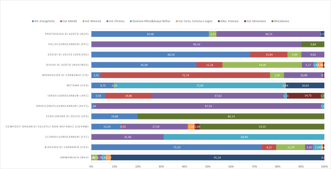
The EPRTR (European Pollutant Release and Transfer Register) is the integrated register developed by the EU under Regulation (EC) No 166/2006, with the aim of making publicly available information on environmental impacts from industrial facilities that meet the criteria established in the legislation. This indicator represents the total air emissions from industrial facilities that have reported such emissions to the national PRTR register. The air emissions declared for 2020 refer to 34 substances (non-zero values). Comparing 2020 data with 2007, it is observed that for 25 substances, total national atmospheric emissions have decreased (for 23 of these, reductions exceed 40%), while for 8 substances, overall emissions have increased (including: hydrogen cyanide +356% from 2007, hydrofluorocarbons +19%, and ammonia +109%).
PRTR REGISTER: WATER EMISSIONS (FORMERLY INES REGISTER: WATER EMISSIONS)
Data aggiornamento scheda: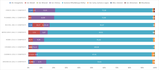
The EPRTR (European Pollutant Release and Transfer Register) is the integrated register established by the EU based on Regulation (EC) No. 166/2006, aimed at making publicly available information on environmental impacts caused by industrial facilities falling under the criteria set out in the regulation.
This indicator represents total emissions into surface waters and pollutant transfers in wastewater from industrial facilities that reported such data to the national PRTR register. For the year 2020, 60 substances were reported as present in emissions into surface water bodies, while 49 substances were declared in pollutant transfers via wastewater conveyed through pipelines to external treatment facilities.
The PRTR activity groups that contribute the highest percentages of reported pollutant emissions into both wastewater and surface waters are generally those related to "Waste and Wastewater Management" and "Chemical Industry".
RELATIVE RICHNESS AND ABUNDANCE OF BIRDS IN ITALY
Data aggiornamento scheda:The indicator measures the abundance and diversity of bird populations in Italy throughout the year, based on bird ringing data. This assessment helps define Italy’s role in the spatial-temporal distribution of European avifauna. Data from 2019-2020 confirm Italy’s crucial importance as a major migration corridor between Europe and Africa and contribute to identifying critical periods for bird species, which is essential for conservation and management purposes.
TERRESTRIAL PROTECTED AREAS
Data aggiornamento scheda: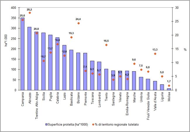
In Italy, as of today, 843 terrestrial protected areas (including those with a marine component) have been established, covering a total protected surface of over 3 million hectares, which corresponds to approximately 10.5% of the national terrestrial area. Analyzing the historical series (1922-2019), it is possible to observe, especially from the mid-1970s onward, a positive trend in terms of both the number and surface area of terrestrial protected natural areas. However, since 2008-2009, there has been a certain stabilization in the growth trends.