Stefania Ercole (ISPRA), Benedetta Brecciaroli (MASE)
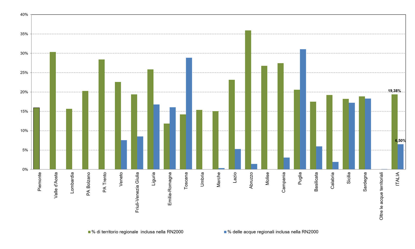
The Natura 2000 Network, established under the Habitats and Birds Directives (known as the Nature Directives), consists of 2,649 sites in Italy, covering a total area, net of overlaps, of 5,844,888 hectares on land, equal to 19.4% of the national territory, and a marine area of 2,344,963 hectares, equal to 6.5% of the waters under national jurisdiction (territorial waters and EPZ) (2025 data, transmitted to the Commission in January 2026). The Network is fundamental for the implementation of the Nature Directives, but it is also important in relation to the targets of the European and National Biodiversity Strategies for 2030 (EBS2030 and NBS2030), which call for expanding protected zones to at least 30% of the land surface and 30% of marine waters; in addition to the N2000 Network sites, all areas subject to protection, including National and Regional Parks and all other protected areas, contribute to this target. In the Italian regions and autonomous provinces, the Network has a heterogeneous extension, with percentages of protected regional territories and waters ranging from 12% (Emilia-Romagna) to 36% (Abruzzo) on land and from less than 1% (Marche) to 31% (Puglia) at sea.
Response indicator that measures the extension and national and regional percentage coverage of the Natura 2000 Network. The number and surface area of the Network sites in the terrestrial and marine context is shown. This includes data relating to Special Protection Areas (SPAs) established under the Birds Directive and Sites of Community Importance subsequently designated as Special Areas of Conservation (SCI-SACs) established under the Habitats Directive.
Evaluate at national and regional level the extension of SPAs and SCI-SACs and the percentage of land and sea surface covered by the Natura 2000 Network; show the regional distribution of the sites and follow their evolution over time.
The Natura 2000 Network is an ecological network for the conservation of biodiversity, spread throughout the European Union, made up of Special Protection Areas (SPAs) established by Member States pursuant to the Birds Directive and Sites of Community Interest (SCI), identified pursuant to the Habitats Directive; the SCIs are subsequently designated as Special Areas of Conservation (SAC). The regulatory objective of the Natura 2000 Network is to guarantee the maintenance or restoration, in a satisfactory state of conservation, of natural habitats and species of community interest, through the protection of sites of significant importance for the conservation of biodiversity.
The Birds Directive 79/409/EEC, repealed and completely replaced by Directive 2009/147/EC which maintains its fundamental objectives, was implemented in Italy with Law no. 157 of 11 February 1992 and is aimed at the protection and management of all bird species living naturally in the wild in European territory and regulates their exploitation.
The Habitats Directive 92/43/EEC (implemented in Italy with Presidential Decree 357/97 amended and integrated by Presidential Decree 120/2003) is aimed at "safeguarding biodiversity through the conservation of natural habitats, as well as wild flora and fauna in European territory" (art 2); to achieve this objective, it provides for measures aimed at ensuring the maintenance or restoration to a satisfactory state of conservation of the habitats and species of Community interest listed in its annexes.
The designation of SACs, provided for by article 4 of the Habitats Directive and art. 3 paragraph 2 of Presidential Decree 357/97 and subsequent amendments, is a fundamental step for the full implementation of the Network because it guarantees the definition of conservation objectives and measures that are site-specific, species-specific or specific habitat and offers greater security for the management of the Network. The same principle also applies to SPAs.
The Habitats Directive also establishes rules for the management of sites and Impact Assessment (art. 6), financing (art. 8), monitoring and preparation of national reports on the implementation of the provisions of the Directive (articles 11 and 17) and the issuing of any exemptions (art. 16).
The surfaces protected within the Natura 2000 Network contribute to achieving the European and national targets for Biodiversity for 2030, which aim to protect at least 30% of the earth's surface and 30% of the sea surface. The European Strategy (SEB2030) was approved by the Member States in October 2020 and the National Strategy (SNB2030) was derived from it in Italy, adopted in August 2023 with Ministerial Decree no. 252.
The indicator does not evaluate the level of implementation of management tools within the sites of the Natura 2000 network (management plans, site-specific conservation objectives and measures, etc.) and therefore does not directly measure the effectiveness of conservation actions.
-
National
Regional 20/20
2003 – 2025
The official data published annually by MASE relating to the number and surface area of the Natura 2000 Network sites on land and at sea (net surface area excluding overlaps) for the entire national territory and for each region and autonomous province are represented in graphs and tables. The regional areal extension of the Network is analyzed in absolute terms (hectares occupied by sites in the different regions) and percentages compared to the regional surface area. Since December 2023, MASE has introduced the "Beyond territorial waters" category for marine sites to indicate marine sites outside territorial waters and, since then, the percentage of occupation of the Network in the marine environment has been calculated taking this into account.
The state can be considered good in consideration of the vast extension of the Network which in Italy, with 2,649 sites established, protects over 8,100,000 hectares (5,844,888 hectares on land and 2,344,963 hectares at sea), i. e. 19.4% of the land surface and 6.5% of the sea surface (Figure 3). These surfaces contribute to achieving the target of the European and national Biodiversity Strategies for 2030, which call for at least 30% of the earth's surface and 30% of the sea surface to be protected. Furthermore, the identification, underway in recent years by the autonomous regions and provinces, of site-specific conservation objectives and measures compliant with the ecological needs of the species and habitats protected by the Nature Directives will contribute to the effectiveness of the management of the sites.
The trend is positive as the expansion process of the RN2000 has constantly progressed since 2003, with an increase in the protected area and the designation of new sites (Figures 1, 2). From 2017 to 2024, there was an expansion of the network, especially in the marine area, with an almost quadrupled sea surface area. In 2025, the overall number of sites in the network remained unchanged, but there were expansions of the perimeters of several marine sites, with a slight increase in their overall extension.
| Allegati |
|---|
Titolo
Table 1: Natura 2000 Network Sites by Region/Autonomous Province: total number, total area in hectares, and percentage of land and sea areas, net of any overlaps between SCI-SACs and SPAs (updated Dec. 2025–Jan. 2026) Fonte
MASE (https://www.mase.gov.it/pagina/sic-zsc-e-zps-italia) Note
In 2023, the category “Beyond Territorial Waters” was added to the list of regions and public administrations to indicate marine sites located outside territorial waters. |
Thumbnail
Titolo
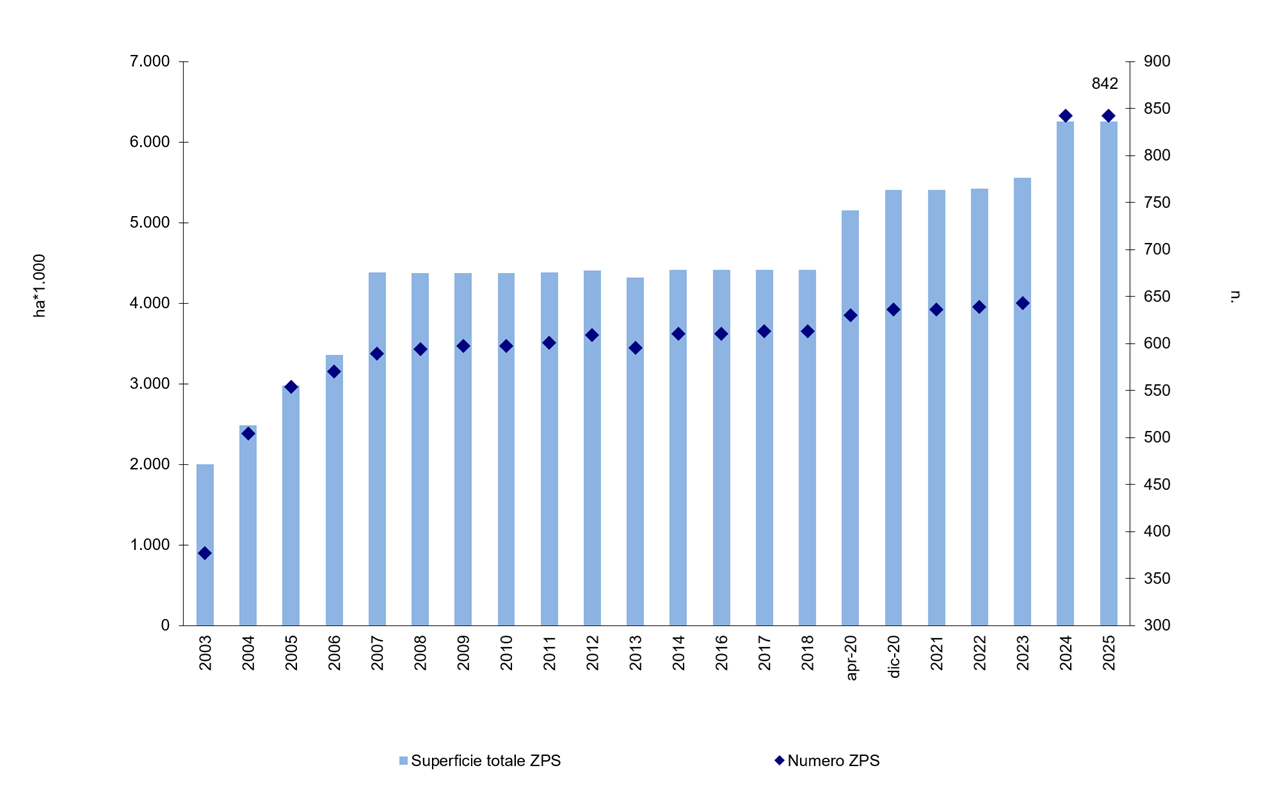
Figure 1: Number and total annual area (on land and at sea) of Special Protection Areas (A sites and C sites) in Italy (updated Dec. 2025–Jan. 2026) Fonte
ISPRA analysis based on MASE data (https://www.mase.gov.it/pagina/sic-zsc-e-zps-italia) Note
Type C sites (SPAs that coincide with SCI-SCIs) are also included in the tally; data for 2015 and 2019 are not available |
Thumbnail
Titolo
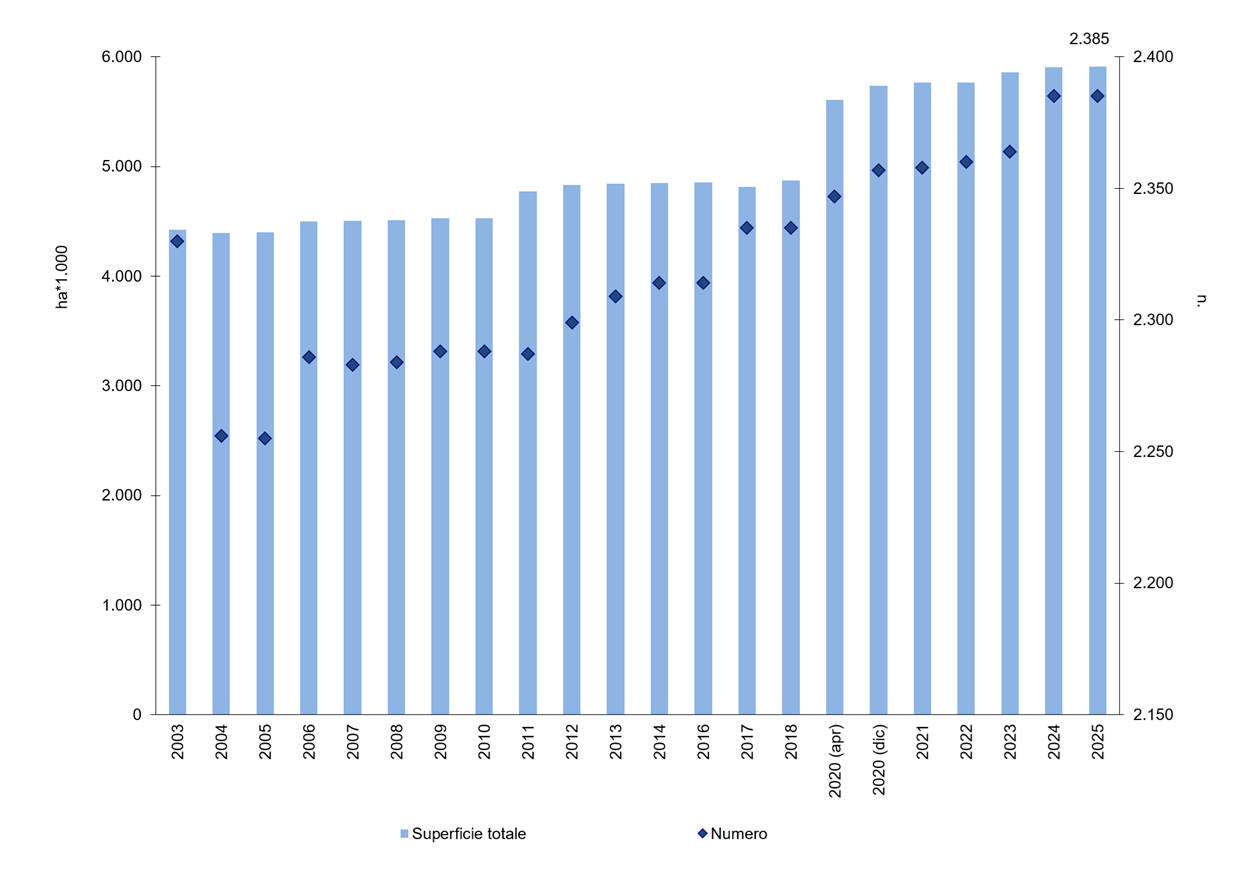
Figura 2: Numero e superficie totale annua (a terra e a mare) dei SIC-ZSC in Italia (siti B e siti C) (agg. dic.2025-genn.2026) Fonte
ISPRA analysis based on MASE data (https://www.mase.gov.it/pagina/sic-zsc-e-zps-italia) Note
Since 2013, the total number of SCI and SACs has been reported. Type C sites (SCI-SACs that coincide with SPAs) are also included in the count. Data for 2015 and 2019 are not available. |
Thumbnail
Titolo
Figure 3: Percentage coverage of the Natura 2000 Network on land and at sea for Italy and for each region/autonomous province, excluding overlaps between sites (updated Dec. 2025–Jan. 2026) Fonte
ISPRA analysis based on MASE data (https://www.mase.gov.it/pagina/sic-zsc-e-zps-italia) Note
The graph does not include the two sites (17,004 ha, equal to 0.08%) located “beyond territorial waters.” The area of site IT1201000 (Gran Paradiso National Park), which lies partly in Valle d’Aosta and partly in Piedmont, has been allocated to each region based on the portion that actually lies within its territory. The area of site IT7110128 (Gran Sasso-Monti della Laga National Park), which lies in Abruzzo, Lazio, and Marche, has been allocated to each region based on the portion that actually lies within its territory. The area of site IT7120132 (Abruzzo National Park), which lies in Abruzzo, Lazio, and Molise, has been allocated to each region for the portion actually located within its territory. Since sites IT3230085, IT3230006, and IT3230089 are located partly in Veneto and partly in Friuli, the areas were calculated by allocating to each region the portion of the site that actually lies within its territory. The number and extent of the sites were calculated by excluding overlaps between SCIs and SPAs. The percentages are calculated relative to regional land and water areas. |
Thumbnail
Titolo
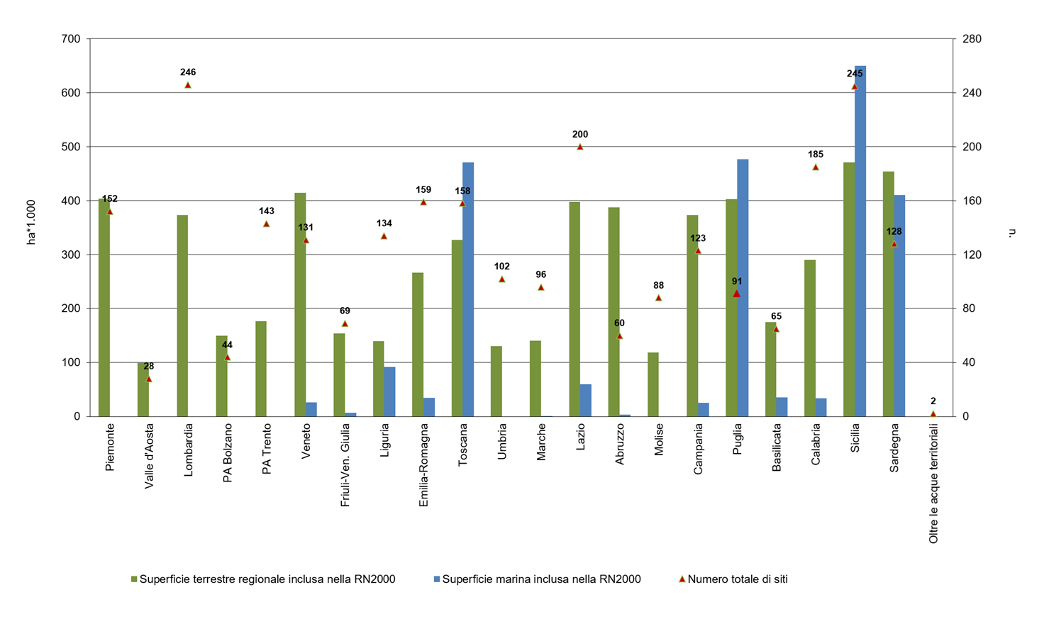
Figure 4: Total area of the N2000 Network on land and at sea (in hectares) and the number of designated sites for each region and autonomous province (updated Dec. 2025–Jan. 2026) Fonte
ISPRA analysis based on MASE data (https://www.mase.gov.it/pagina/sic-zsc-e-zps-italia) |
The Natura 2000 network in our country is made up of a total of 2,649 sites distributed on land and at sea (Table 1). This includes type A sites, which are only SPAs, type B, which are only SCI/SACs, and type C sites which are both SCI/SACs and SPAs. In type C sites, both species and habitats protected under the Habitats Directive and avifauna species protected by the Birds Directive can be protected.
Data transmitted to the European Commission in January 2026 shows that the network currently consists of a total of 842 A+C sites and 2,385 B+C sites (Figures 1 and 2).
In 2024 there was a significant increase in A+C sites (Figure 1), which went from 643 in 2023 to 842 sites in 2024, a value which remained unchanged in 2025. This increase is mainly due to the revision of the attribution of the type of site carried out by some regions, which reclassified sites previously classified only as SPAs or as SCI/SACs into C sites (SPAs overlapping with SCI/SAC). For this reason, in 2024 there was an increase in the number and surface area of SPAs (understood as the sum of sites A and C) (Figure 1), since most of the new C sites were previously type B sites.
The overall number of SCI/ZSC sites (intended as the sum of B and C sites) increased between 2023 and 2025, going from 2,364 to 2,385 sites (Figure 2).
According to data transmitted to the European Commission in January 2026, the Network has a total area, net of overlaps, of 5,844,888 hectares on land (they were 5,845,489 in December 2024), equal to 19,4 % of the national territory, and a sea surface of 2,344,963 hectares (there were 2,338,693 in December 2024), equal to 6.5% of the waters (Table 1). These surfaces contribute to achieving the 30% target of SEB2030 and SNB2030, together with the areas subjected to other forms of protection (National, Regional Parks, other protected areas), although it must be remembered that N2000 sites are often included, or partially overlapped, with other protected areas.
At a regional scale the Network has a rather heterogeneous extension (Figure 3). The regions with the highest percentage coverage (calculated with respect to the regional territories) are Abruzzo (36%), Valle d'Aosta (30%), the autonomous province of Trento (28%), Molise (27%), Campania (27%) and Liguria (26%) (Figure 3, Table 1). In the marine context, the highest percentages are observed in Puglia (31%) and Tuscany (29%), but also in Emilia-Romagna, Liguria, Sardinia and Sicily (with values from 16% to 18%).
Analyzing the regional extension of the Network in absolute terms (hectares occupied by the sites), however, we note that four regions have very significant extensions both on land and in the sea: Sicily (245 sites covering 470,893 hectares on land and 650,251 hectares at sea), Sardinia (128 sites, with 454,163 hectares on land and 410,648 hectares at sea), Puglia (91 sites, with 402,504 hectares on land and 477,034 at sea) and Tuscany (158 sites, with 327,005 hectares on land and 471,191 at sea) (Figure 4, Table 1).
To evaluate the effectiveness of the Network, it will be important in the future to analyze the implementation of management tools within the sites, with particular reference to conservation objectives and measures identified in recent years by the regions and autonomous provinces.