NATURA 2000 NETWORK
Data aggiornamento scheda:
The Natura 2000 Network, established under the Habitats and Birds Directives (known as the Nature Directives), consists of 2,649 sites in Italy, covering a total area, net of overlaps, of 5,844,888 hectares on land, equal to 19.4% of the national territory, and a marine area of 2,344,963 hectares, equal to 6.5% of the waters under national jurisdiction (territorial waters and EPZ) (2025 data, transmitted to the Commission in January 2026). The Network is fundamental for the implementation of the Nature Directives, but it is also important in relation to the targets of the European and National Biodiversity Strategies for 2030 (EBS2030 and NBS2030), which call for expanding protected zones to at least 30% of the land surface and 30% of marine waters; in addition to the N2000 Network sites, all areas subject to protection, including National and Regional Parks and all other protected areas, contribute to this target. In the Italian regions and autonomous provinces, the Network has a heterogeneous extension, with percentages of protected regional territories and waters ranging from 12% (Emilia-Romagna) to 36% (Abruzzo) on land and from less than 1% (Marche) to 31% (Puglia) at sea.
WETLANDS OF INTERNATIONAL IMPORTANCE
Data aggiornamento scheda:
To date, there are 63 Italian wetlands included in the official list of sites of the Ramsar Convention, recognized by the Ramsar Secretariat as wetlands of international importance, covering a total of 81,091 hectares. Overall, the 66 Italian Ramsar sites (63 designated by the Convention Secretariat and 3 in the process of designation) are distributed across 15 regions. The regions with the largest and most numerous areas are Emilia-Romagna (10 sites, with an area equal to 23,112 ha), Tuscany (11 sites with an area equal to 20,755 ha), and Sardinia (9 sites, with an area equal to 13,308 ha). The level of implementation of protection and management instruments for these areas, necessary to ensure the conservation of habitats, flora, and fauna linked to aquatic ecosystems, is not sufficiently known.
NATIONAL PROTECTED TERRESTRIAL AND MARINE AREA
Data aggiornamento scheda:
The European Commission adopted the EU Biodiversity Strategy for 2030 (EBS 2030, COM(2020) 380 final), which calls on Member States to protect at least 30% of national land territory and 30% of marine areas, with at least one third of these areas under strict protection. These objectives have been incorporated into the Italian National Biodiversity Strategy for 2030 (NBS 2030).
This indicator integrates spatial data relating to the main biodiversity protection systems in Italy (protected areas and the Natura 2000 Network). It calculates the extent of Italian territory currently protected on land and at sea, assesses changes from 1991 to 2024, and shows the gap between the percentage of protected land and marine areas and the 30% target set by the EBS 2030.
After removing overlaps between protected areas and Natura 2000 sites, national protected coverage currently amounts to approximately 4,071,482 hectares at sea, corresponding to 11.6% of Italian territorial waters and the Ecological Protection Zone (EPZ), and about 6,532,887 hectares on land, corresponding to 21.7% of Italian territory. The extent of overlapping areas—those falling both within a protected area and a Natura 2000 site—has increased over time, reaching 893,839 hectares at sea and 2,447,065 hectares on land in 2024. Trends show that the national percentage of protected surface has stabilised since 2006 for marine areas and since 2011 for terrestrial areas. To achieve the 30% target set by the EBS 2030, an additional gap of about 18% of marine surface still needs to be protected (around 6,600,000 hectares), along with 8% of terrestrial surface (around 2,500,000 hectares).
TERRESTRIAL PROTECTED AREAS
Data aggiornamento scheda:
In Italy, a total of 843 terrestrial protected areas (including those with a coastal component) have been established to date, covering more than 3 million hectares, equivalent to about 10.5% of the country’s land surface. An analysis of the historical series (1922–2024) shows consistently positive trends—particularly from the mid-1970s—in both the number and the extent of terrestrial protected areas, while growth trends have tended to stabilize since 2008–2009.
LAND CONSUMPTION IN PROTECTED AREAS
Data aggiornamento scheda:
The consumed soil within the terrestrial portion of Italian protected areas included in the Official List of Protected Areas (EUAP, 2010, updated with newly designated national protected areas established after 2010) is assessed with reference to National Parks, State and Regional Nature Reserves, Regional Nature Parks, and the other categories of national and regional protected natural areas.
As of 2024, 1.88% of the more than three million hectares of terrestrial EUAP areas (58,328 hectares) has been consumed, with the highest percentage in Campania (3.82%) and the lowest in the Alpine regions (Valle d’Aosta, Trentino-Alto Adige, and Friuli Venezia Giulia).
Between 2023 and 2024, Italian protected areas recorded an increase in soil consumption that remained below the national average (0.26 m² of change per hectare, compared to a national value of 2.60 m²/ha), amounting to a total of 80.96 hectares of newly consumed soil, more than 46% of which is concentrated in Abruzzo, Lazio, and Campania.
MARINE PROTECTED AREAS
Data aggiornamento scheda:
Both the number of protected areas and the extent of protected marine surface have steadily increased over time. At present, 30 Marine Protected Areas (MPAs) have been established in Italy, across 10 Italian regions, along with a further 10 areas protecting coastal marine stretches.
Sicily and Sardinia host the largest share of marine protected areas, both in terms of number and area of protected surface. Between 2012 and 2023, at the national level, the surface of Marine Protected Areas (MPAs) increased by 3.1%, following the establishment in 2018 of the two MPAs of Capo Testa–Punta Falcone in Sardinia and Capo Milazzo in Sicily, and in 2023 of the Capo Spartivento MPA in Sardinia.
ANTHROPOGENIC PRESSURE IN WETLANDS OF INTERNATIONAL IMPORTANCE
Data aggiornamento scheda:
A significant portion of Italy’s Ramsar sites is subject to anthropogenic pressure due to both the presence of settlements and infrastructure and agricultural activities. In 45 out of 65 cases, agricultural areas occupy more than half of the Ramsar site's territory. While urbanized areas and infrastructure have a smaller spatial extent, they still contribute to the pressure affecting Ramsar sites. Approximately one-quarter of these areas experience high or very high levels of urbanization pressure. A total of 68% of wetlands fall within Class III (high pressure) and Class IV (very high pressure), highlighting the fragile balance in which these environments exist. Only 15% of the areas fall into Class I (low pressure), while 17% belong to Class II (moderate pressure).
IMPLEMENTATION STATUS OF PLANNING IN NATIONAL PARKS
Data aggiornamento scheda:
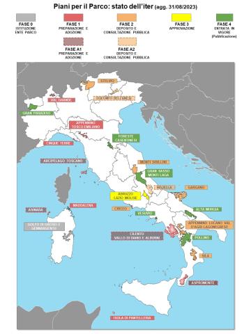
The indicator, referring to the 25 National Parks established as of 08/31/2023, represents the implementation status of Park Plans under Article 12 of Law 394/1991 within the complex process of drafting - adoption - approval by the competent authorities. Compared to 2020, the number of active plans has increased by one unit (Pollino National Park), reaching a total of 12. However, a general delay persists, particularly regarding plans pending approval. Considering the legal timeframe for the entry into force of a Park Plan, all National Parks (NPs) should have had an active plan by now. Instead, an average delay of 21 years in the approval process has been recorded.
OVERLAP OF TERRESTRIAL PROTECTED AREAS WITH KEY BIODIVERSITY AREAS
Data aggiornamento scheda:
In order to assess whether protected areas have been designated based on scientific criteria, including ecologically representative areas (Margules & Pressey, 2000; Maxwell et al., 2020), the overlap between terrestrial protected areas in our country and Key Biodiversity Areas (KBA, IUCN, 2016) has been calculated. The protected areas considered include those in the data bank of the Common Database on Designated Areas (CDDA) (now Nationally designated areas of Europe - NatDA), and the Natura 2000 Network. KBAs identify key areas for biodiversity conservation and, according to the European Commission’s guidance document on achieving the 30% target ("Criteria and guidance for protected areas designations," Brussels, 28/1/2022), are among those to be considered for designation as protected areas. The indicator used corresponds to the one adopted internationally to evaluate progress toward the Sustainable Development Goals (SDGs) for 2030 (SO4-3.T1: National estimates of the average proportion of Terrestrial KBAs covered by protected areas in %).
The results indicate that, after accounting for overlaps between CDDA protected areas and Natura 2000 sites, 75.20% of the national terrestrial protected area overlaps with KBAs identified at the national level, demonstrating a fair inclusion of important biodiversity areas.