Aree
PERCENTAGE OF TREATED WASTEWATER
Data aggiornamento scheda:
The percentage of treated wastewater reflects the amount of biodegradable organic load that reaches urban wastewater treatment plants compared to the total organic load produced by agglomerations (2,000 PE or more) across the national territory. In 2022-2023, this percentage is 93.51%, an increase compared to 2020 (93.3%).
WASTEWATER TREATMENT PLANTS - COMPLIANCE OF THE URBAN WASTEWATER SEWAGE SYSTEM
Data aggiornamento scheda:
The presence or absence of a sewage network and the percentage of wastewater conveyed into collection systems indicate the degree of compliance with the requirements of the applicable regulations. In 2022-2023, the national compliance rate is 99.1%. Of the organic load, 95.7% is conveyed into the sewer system, 3.6% is treated through individual systems, while 0.7% is not connected.
WASTEWATER TREATMENT PLANTS - COMPLIANCE OF URBAN WASTEWATER TREATMENT SYSTEMS
Data aggiornamento scheda:
Compliance monitoring allows for an understanding of the technological adaptation status of urban wastewater treatment systems for agglomerations greater than or equal to 2,000 PE (Population Equivalent). This is particularly useful for planning potential actions aimed at water protection.
Between 2022 and 2023, out of the 3,037 agglomerations analyzed, approximately 77% were found to be compliant, 13.8% non-compliant, 4.6% partially compliant, and 4.6% with data unavailable. A 100% compliance rate is recorded in Piedmont, Emilia-Romagna, Umbria, and the Autonomous Provinces of Trento and Bolzano.
WATER ABSTRACTION FOR CIVIL USE
Data aggiornamento scheda:
The indicator refers to 2022 and is drawn up on the basis of Istat data relating to the last “Nable Review for Civil Use” carried out in 2023 and published in 2024. The information is provided on a national, regional and by hydrographic district, divided in turn into removal from the surface and underground body water. The levy values are compared with those detected in the previous "Nail census for civil use" of 2020. Also in 2022, compared to the previous 2020 census, the water withdrawal for civil use in Italy has decreased slightly.
AIR TEMPERATURE
Data aggiornamento scheda:
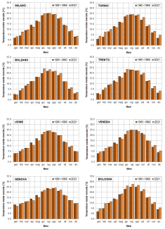
The indicator provides a representation of the trend of the average monthly temperatures recorded in the provincial capital city / region during 2021, compared with that of the average monthly temperatures calculated for the same locations over the thirty-year period 1961-1990. During 2021 there was a general increase in average monthly temperatures compared to the reference period, with exceedances of the reference values on average for 8 months and in particular in the summer and winter months. It is mainly the cities of the North where the temperature increases assume significant values in species in the months of February and December. It should be noted that in the months of April and October the temperature values, in most of the capitals, were on average lower than in the reference period.
ARTIFICIAL COASTLINE WITH MARITIME AND COASTAL DEFENSE STRUCTURES
Data aggiornamento scheda:
The indicator provides a measure of coastal engineering interventions that directly alter geomorphology, coastal dynamics and often the natural character of long stretches of coast. The reference data for the calculation of the indicator concern three main aggregations within which the various types of works can be grouped: the port infrastructures, the coastal defense works built near the shore and the set of the other differently characterized structures, which however retain the peculiarity of being leaning against the coastline. The elaborations led to the creation of graphs useful to assess the situation in 2020 of the national coastal artificialization and the variation that took place with reference to the years 2000, 2006 and 2020. In general terms, there is an increase in artificialization ranging from 696 km in 2000, to 714 km in 2006, to 770 km in 2020 (about 8,300 km of national coast), mainly due to the growth of port works and coastal defense works grazing on the coast.
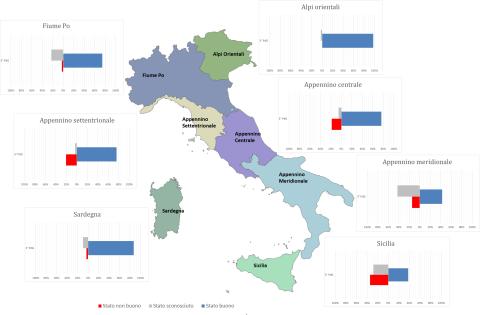
CHEMICAL STATUS OF COASTAL MARINE WATERS
Data aggiornamento scheda:
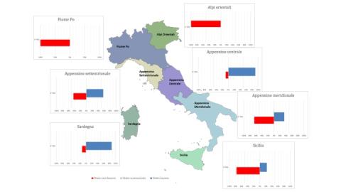
Coastal marine waters are “surface waters located inside an imaginary line, every point of which is one nautical mile seaward from the nearest point of the baseline used to determine the limit of territorial waters, and which may extend up to the outer limit of transitional waters” (Paragraph 1 of Article 74 of Legislative Decree 152/2006). The legislation (Legislative Decree 152/2006) mandates the achievement of a “good” status of water bodies (chemical + ecological) by the dates set by current legislation; failure to achieve environmental objectives results in the implementation of remediation measures. Based on the analysis of data reported by the Districts in the 3rd Reporting to the European Commission for the 2016–2021 six-year period (3rd RBMP), the chemical status of Italian coastal marine waters appears heterogeneous. This heterogeneity is evident both in terms of the number of water bodies identified per district and their classification. The Eastern Alps and Po River Districts have all water bodies in a “not good” chemical status, while in Sicily and the Southern Apennines District, over 60% of the water bodies are in a “not good” status. The Northern Apennines, Central Apennines, and Sardinia Districts, instead, register more than 50%, more than 90%, and more than 80%, respectively, in a “good” chemical status. At the national level, 51% of coastal marine water bodies are in good chemical status. Comparing the 2nd and 3rd RBMPs, in the 2nd RBMP, water bodies with unknown chemical status amounted to 26% (147 out of 561), whereas in the 3rd RBMP, only one water body has an unknown status. Generally, water bodies in good chemical status are comparable between the two RBMPs—52% and 51%, respectively—while water bodies in not good chemical status increased in the 3rd RBMP (49%).
CHEMICAL STATUS OF GROUNDWATER (SCAS)
Data aggiornamento scheda:
The Chemical Status of Groundwater (SCAS) indicator assesses the chemical quality of Italian groundwater bodies by comparing pollutant concentrations with the Environmental Quality Standards and Threshold Values specified in Tables 2 and 3 of Ministerial Decree (DM) 6/7/2016.
Depending on whether these concentration limits are met, a groundwater body is classified as having either good or poor chemical status. This classification, along with quantitative status, determines the overall groundwater condition. The indicator is based on data from the classification of water bodies reported in WISE Reporting for the 3rd River Basin Management Plan (RBMP).
At the national level, during the 2016-2021 classification period related to the 3rd RBMP, there was an increase in groundwater bodies classified as having good chemical status, reaching 70% of the total (compared to 58% in the 2nd RBMP). The percentage of water bodies classified as poor was 27%.
At the district level, the percentage of groundwater bodies with good chemical status ranges from 56% in the Sicily District to 85% in the Eastern Alps District. Across all hydrographic districts, the number of water bodies with unknown status has significantly decreased compared to the previous cycle, with all water bodies now classified in the Eastern Alps, Southern Apennines, and Sicily Districts.
CHEMICAL STATUS OF INLAND SURFACE WATERS
Data aggiornamento scheda:
The indicator provides an assessment of the chemical quality of Italian surface water bodies. The chemical status is evaluated based on the concentration of chemical substances in the water and biota matrices, specifically those listed in the Priority Substances List (Table 1/A of Legislative Decree 152/2006 and subsequent amendments). These substances are classified as priority, priority hazardous, and other substances.
For each substance in the Priority Substances List, Italian legislation—implementing European Directives—establishes Environmental Quality Standards (EQS) that must be met for a water body to be classified as having good chemical status. The chemical status, together with the ecological status, contributes to the overall “environmental status” evaluation of each water body.
The indicator was developed using classification data from the WISE Reporting of the 3rd River Basin Management Plan (RBMP). At both the national and district levels, an increase in the number of water bodies classified as having good chemical status has been observed for rivers and lakes, along with a decrease in the number of unclassified water bodies, compared to the previous cycle.
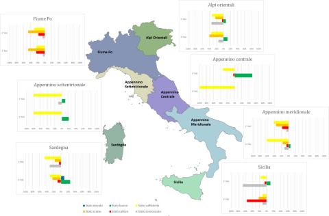
CHEMICAL STATUS OF TRANSITIONAL WATERS
Data aggiornamento scheda:
The legislation (Legislative Decree 152/2006) mandates achieving good status of water bodies (chemical + ecological) by the deadlines established by the current legislation. The analysis of chemical status shows heterogeneous values among the districts, with 100% of water bodies in good status only for the Central Apennines and 52% for Sardinia. In all other districts, the percentage of water bodies in good status never exceeds 50% and ranges from 3% in the Eastern Alps to 40% in the Northern Apennines.
A comparison between the status in the 2nd Water Management Plan (WMP) cycle and that in the 3rd cycle shows maintenance of good chemical status for 100% of the water bodies in the Central Apennines, an improvement for those in the Northern Apennines (from 30% to 40%), Sardinia (from 12% to 52%), and Sicily (from 11% to 17%), and a worsening for the water bodies in the Eastern Alps District (from 51% to 3%), Po River (from 65% to 23%), and Southern Apennines (from 18% to 11%).
At the national level, the number of water bodies in good status is 56 out of 172 (33%) in the 2nd WMP cycle, while in the 3rd cycle it is 42 out of 146 (29%).
CHEMICAL SUBSTANCES IN GROUNDWATER
Data aggiornamento scheda:
Chemical monitoring of groundwater bodies during the period 2018–2020 revealed that the most critical anthropogenic substances on a national scale for chemical status are nitrates and trichloromethane. Among the various substances of potential natural origin present in groundwater bodies, electrical conductivity—related to the presence of chlorides—stands out as an excellent indicator of groundwater salinization. This salinization can stem from marine origins in coastal aquifers or from deep fossil waters.
Between 2014 and 2020, nitrate concentrations remained stable in 78.8% of the monitoring stations, decreased in 11.8%, and increased in the remaining 9.4%. The regions of Abruzzo and Emilia-Romagna reported the highest percentages of stations with decreasing trends (22.8%), while Lazio recorded the highest percentage of stations with increasing trends (20.6%).
Trichloromethane concentrations were stationary in 72.6% of the stations, showed a decreasing trend in 24.9%, and an increasing trend in only 2.5%. High percentages of stations with decreasing trends were observed in Marche (81.4%) and Piedmont (70.7%).
Electrical conductivity trends were stationary in 78.6% of the stations, decreasing in 4.6%, and increasing in the remaining 16.8%. Emilia-Romagna recorded the highest value for decreasing trends (14.5%), while Lazio had the highest percentage of increasing trends (25%).
CHEMICAL SUBSTANCES IN SURFACE WATERS
Data aggiornamento scheda:
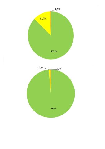
In 2017, chemical monitoring of watercourses was conducted by ARPA/APPA at a total of 1,867 monitoring stations across 15 regions and 2 autonomous provinces.
The indicator's representation considered both the Environmental Quality Standards - Annual Average (EQS-AA) and Environmental Quality Standards - Maximum Allowable Concentration (EQS-MAC) for surface waters, as defined in Legislative Decree 172/2015.
At the national level, 87.1% of stations showed no exceedances of EQS-AA, and 98.6% of stations showed no exceedances of EQS-MAC.
COASTAL DYNAMICS
Data aggiornamento scheda:
The indicator provides the national and regional estimate of the state conservation of Italian coasts in 2020 and of the changes due to erosion or progress suffered since 2006, useful for the assessment of the vulnerability of coastal areas and the risk to which urban centers, infrastructure and socio-economic activities that develop near the coast are exposed. In 2020 there was a significant instability over 1,913 km of coastline, of which 943 km for erosion and 970 km for advance, however, compared to the previous surveys (1950-2000, 2000-2006), there is a slight trend to greater stability and an increase in the stretches of coast in progress.
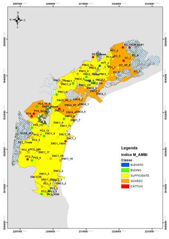
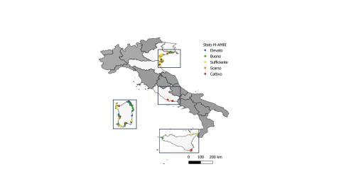
COASTAL MARINE WATERS - BIOLOGICAL QUALITY ELEMENT BENTHIC MACROINVERTEBRATES M-AMBI-CW
Data aggiornamento scheda:
The ecological classification index of the Biological Quality Element "benthic macroinvertebrates," M-AMBI (Multimetric-AZTI Marine Biotic Index), allows a synecological evaluation of the ecosystem under analysis. It is based on the analysis of the structure of benthic macroinvertebrate communities, considering the ecological value of macrozoobenthic species in soft sediments. Species are divided into five ecological groups (first-order opportunistic, second-order opportunistic, tolerant, sensitive/tolerant, and sensitive) based on their sensitivity to gradients of environmental stress. The index describes the quality status of the Biological Quality Element "benthic macroinvertebrates" in five classes: High, Good, Moderate, Poor, and Bad.
Overall, no critical situations were identified for the period 2017–2022 in the coastal regions where data are available. The analysis indicates that 74% of monitoring stations are in High or Good status, while 1% of stations are in Bad status.
COASTAL MARINE WATERS - BIOLOGICAL QUALITY ELEMENT MACROALGAE CARLIT
Data aggiornamento scheda:
In the assessment of the ecological quality of coastal marine environments within the framework of the European Directive 2000/60/EC (implemented through Legislative Decree 152/2006 and subsequent amendments), reference is made to the Biological Quality Element (BQE) Macroalgae. In Italy, as stipulated by Ministerial Decree 260/2010, this BQE is assessed using the CARLIT index (Cartography of littoral and upper-sublittoral benthic communities, or, in short, CARtography of LITtoral), which contributes to the classification of the ecological status of marine-coastal water bodies. For the period 2019–2021, over 80% of analyzed stations met the quality standard (at least "good").
COASTAL MARINE WATERS – BIOLOGICAL QUALITY ELEMENT ANGIOSPERMS POSIDONIA OCEANICA PREI INDEX
Data aggiornamento scheda:
In the assessment of the ecological quality of coastal marine environments within the framework of the European Directive 2000/60/EC (transposed by Legislative Decree 152/2006 and subsequent amendments), reference is made to the Biological Quality Element (BQE) Angiosperms. This BQE in Italy, as provided for by the Ministry of the Environment Decree 260/2010, is evaluated through the PREI (Posidonia Rapid Easy Index). In this context, in fact, the meadows of Posidonia oceanica (L.) Delile take on considerable importance in assessing the ecological quality of coastal marine environments, given their wide distribution and sensitivity to sources of disturbance of anthropogenic origin. The classification of this BQE is carried out where, for reasons of geographical distribution, the meadow is present, i.e., in the Tyrrhenian regions and in Apulia. The data analyzed show that more than 80% of the meadows are in "good" or "high" status.
COASTAL MARINE WATERS – BIOLOGICAL QUALITY ELEMENT CHLOROPHYLL a
Data aggiornamento scheda:
The "chlorophyll" parameter is the only direct indicator of phytoplankton biomass available and has taken on the role of a metric for classifying ecological status according to the Biological Quality Element (BQE) – Phytoplankton in coastal waters (Ministerial Decree 260/2010). Chlorophyll is particularly sensitive to changes in trophic levels determined by nutrient (N and P) inputs from catchment basins flowing into the coastal area.
In 2020, high status was recorded in 71.4% of cases, good status in 12.3%, and sufficient status in 16.2%. A general improvement in status was observed in Campania and Marche, while Emilia-Romagna and Sardinia saw a worsening. Marche, Liguria, and Abruzzo maintained all stations at high status.
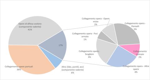
COASTAL PROTECTION STRUCTURES
Data aggiornamento scheda:
To contain erosion and damage caused by storms along the Italian coasts, defense interventions are often carried out aimed at protecting goods and infrastructure and restoring beaches. The indicator “coastal defense works” provides the number, on a national and regional basis, of the different types of “rigid” works of coastal defense (islots, mixed works, brushes, grazing and cliffs) and their variation over time. From 2000 to 2020, if on the one hand it was possible to find an increase in the number of rigid defense works (from about 6,600 to 10,500) indicative of the fragility of coastal environments subjected to increasing anthropogenic pressure; on the other hand, the increasing adoption of submerged or partially emerged defense solutions (from 10% in 2006 to 16% in 2020) shows the trend towards the search for a compromise between the hydraulic efficiency of a lesser impact.
DREDGED SEDIMENTARY SANDS FOR BEACH NOURISHMENT PURPOSES
Data aggiornamento scheda:
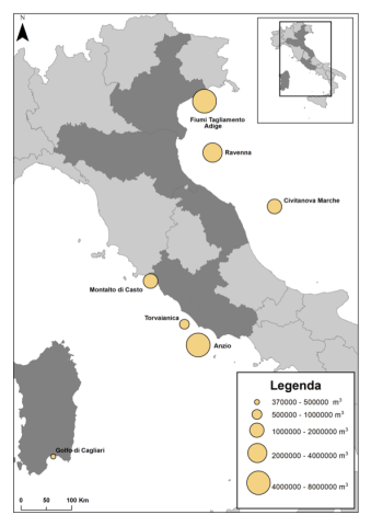
In Italy, the coasts, which develop for over 8,000 km, represent an important strategic resource: they are among the most densely populated areas and home to intense economic activity. The increasing exploitation to which these areas are subjected, associated with natural events (e.g. global climate change), has led to an increase in erosion phenomena. To counteract these processes and to protect housing and infrastructure, over the years numerous rigid defense works have been carried out in several coastal regions (surfaces emerged, submerged, grazing, mixed works, piers, brushes), not always with satisfactory results. An alternative technique that could guarantee a good response to coastal erosion, from an environmental and economic point of view, is replenishment. The replenishment consists in reconstructing the eroded beach by entering suitable sediments (from the granulometric and compositional point of view). A possible response to the need to supply material to be used for replenishment has been identified in the use of relict marine sands (referenced to paleopiagge) from sandy deposits present offshore on the continental shelf. The first dredging of rewashed sands for replenishment began in 1995 in the northern Adriatic Sea (Veneto). Subsequently, other dredgings have affected both other quarries located in the Adriatic Sea (off Emilia-Romagna and Marche) and both quarries located in the Tyrrhenian Sea (off the coast of Sardinia and Lazio).
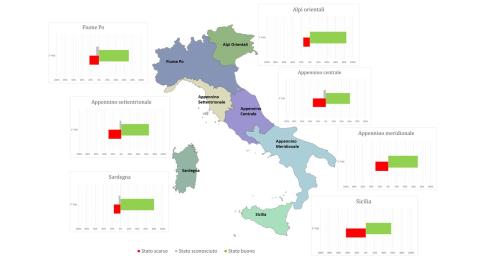
ECOLOGICAL STATUS OF COASTAL MARINE WATERS
Data aggiornamento scheda:
Coastal marine waters are defined as “surface waters situated inside an imaginary line one nautical mile away, at every point, on the outer side from the nearest point of the baseline used to define the territorial sea limit, and potentially extending to the outer boundary of transitional waters.” The legislation (Legislative Decree 152/2006) mandates achieving "good" status (ecological + chemical) for water bodies by the deadlines set by current regulations; failure to meet environmental goals entails remediation measures. Based on the analysis of data reported by Districts in the 3rd Reporting to the European Commission for the six-year period 2016–2021 (3rd WMP), the ecological status of Italian coastal marine waters is heterogeneous. This heterogeneity is expressed in both the number of water bodies identified per district and their ecological classification. The Eastern Alps, Northern Apennines, Central Apennines, Sicily, and Sardinia Districts show a percentage of water bodies in good and high ecological status greater than or equal to 70%. Specifically, in the Sardinia District, more than 40% of water bodies are in high status. Nationally, more than 60% of water bodies (261 out of 394 total) are in good and high ecological status. Comparing data from the 2nd WMP and the 3rd WMP shows that in the 2nd WMP, 27% of water bodies had unknown ecological status (149 out of 561 total), while in the 3rd WMP, only one water body is in unknown ecological status. In general terms, the proportion of water bodies in good and high ecological status increased from 55% in the 2nd WMP to 66% in the 3rd WMP.
ECOLOGICAL STATUS OF INLAND SURFACE WATERS
Data aggiornamento scheda:
The ecological status of surface waters reflects the quality of the structure and functioning of aquatic ecosystems. Directive 2000/60/EC (transposed in Italy with Legislative Decree 152/2006) mandates the achievement of "good" quality status for water bodies, which is determined by the assessment of both ecological and chemical status. The indicator provides an evaluation of the ecological status of surface water bodies—specifically inland waters—based on classification data from the WISE 2022 Reporting related to the 3rd Water Management Plan. At the national level, comparing the ecological quality status data between the 2nd and 3rd Management Plans shows a reduction in water bodies with unknown status, from 18% to 10%, though they are still present. In general, the ecological status has not significantly changed from the previous management cycle, except for the percentage of lakes in good status, which has increased from 17% to 35%.
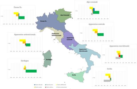
ECOLOGICAL STATUS OF TRANSITIONAL WATERS
Data aggiornamento scheda:
Transitional waters are defined in Legislative Decree 152/2006 as "surface water bodies near a river mouth, partially saline due to their proximity to coastal waters but significantly influenced by freshwater flows." This definition encompasses coastal lagoons and coastal ponds subject to ecological classification. Italian transitional environments are exposed to numerous pressure factors, often leading to degradation of ecological conditions in these fragile ecosystems. The ecological status analysis shows heterogeneous values, both in the number of Water Bodies (WB) and in the distribution across quality classes, with a prevalence of sufficient and poor statuses in all Districts. Comparing the status of the 2nd Water Management Plan (WMP) cycle with that of the 3rd cycle, it is observed that for all hydrographic districts, ecological status remains predominantly sufficient and poor. However, there is an increase in the percentage of water bodies in good status in the Eastern Alps District (from 7% to 11%), Northern Apennines District (from 10% to 20%), Southern Apennines District (from 0% to 6%), and Sardinia District (from 0% to 26%). National analysis of ecological status shows that the number of water bodies in good or high status increased from 9 out of 172 (5%) in the 2nd WMP cycle to 22 out of 146 (15%) in the 3rd cycle.
FLOWS
Data aggiornamento scheda:
The indicator provides an assessment of the trend of water volumes measured in bedside sections of some of the main Italian watercourses compared to the year and the previous decade. For 2021 it was possible to represent the data of scope for 6 sections of closure of as many waterways of national importance (Po, Arno, Adige, Bacchiglione, Serchio and Tiber). In 2021, the annual volumes drained in the measurement sections showed significant increases compared to 2020, with increases of between 6% and 25%, with the exception of the sections on the Adige and the Po.
M-AMBI IN THE VENETIAN LAGOON (BENTHIC MACROINVERTEBRATES)
Data aggiornamento scheda:
The Ecological Classification Index of the Macroinvertebrate Biological Quality Elementary for Coastal Lagoons, M-AMBI (Multivariate-Azti Marine Biotic Index), is based on the analysis of the structure of the mobile macrozoobentonic community and takes into account the tolerance/sensitivity of species, community diversity and specific wealth. The M-AMBI index responds to anthropogenic and natural pressures affecting transition areas and describes the ecological quality status in 5 classes: high, good, sufficient, scarce and bad.
The monitoring of benthic macroinvertebrates for the application of the M-AMBI index has been active in the Venice Lagoon since 2011 with a three-year frequency. In the 12 years of monitoring, 4 sampling campaigns were carried out; in 2022 four water bodies out of eleven are in a “poor” state, the remaining in a “sufficient” state and the trend of comparison between all the years of monitoring is stable.
MAIN MEASURES FOR WATER BODIES
Data aggiornamento scheda:
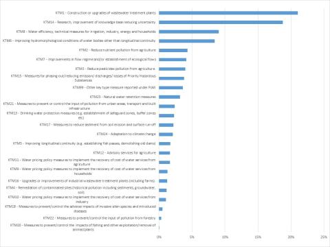
The Water Framework Directive (WFD) - Directive 2000/60/EC - requires that for each river basin district, within the River Basin Management Plan (RBMP), also known as the Water Management Plan (WMP), a "Program of Measures" (PoM) is established. This program, based on the analyses carried out, should enable the achievement of environmental objectives set by the directive (a "good" status for natural water bodies; a "good" potential for heavily modified or artificial water bodies) by 2015. Environmental quality objectives can be exempted or extended in specific cases explicitly provided for by the WFD.
The WFD distinguishes between "basic measures" and "supplementary measures." The former essentially consist of applying measures required by other specific directives (e.g. Nitrates Directive, Habitats Directive) and are listed in Part A of Annex VI of the WFD; the latter are additional measures (e.g. river restoration, knowledge enhancement, fiscal tools) and are included in Part B of Annex VI in a non-exhaustive list.
Given the variety and level of detail of the measures, for reporting purposes, the measures in the PoM are grouped into 25 macro-categories, the "Key-Type of Measures" (KTM). Each KTM serves to mitigate the impact of one or more pressures, and it is possible to link them to each other. In other words, for each KTM, the percentage of significant pressure types these measures aim to mitigate can be represented.
The processed information comes from the six-yearly reporting of Water Management Plans prepared by the district basin authorities as required by the Water Framework Directive -2000/60/EC. The data refer to the period 2010–2015.
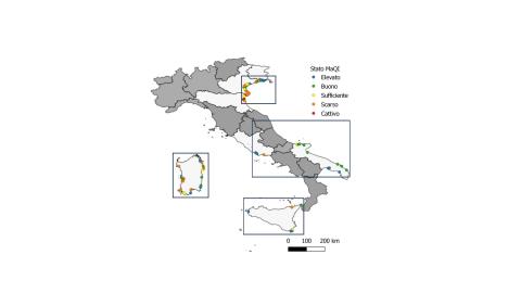
MAQI LAGOON OF VENICE (MACROPHYTE QUALITY INDEX)
Data aggiornamento scheda:
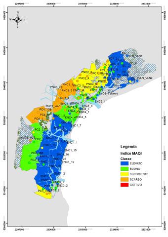
The MaQI (Macrophyte Quality Index) (Sfriso et al., 2014) formally adopted by Italy for the classification of the ecological status of transition environments under Directive 2000/60/EC, integrates the two organic quality elements macroalgae and aquatatal fanerogages.
The MaQI responds to anthropogenic pressures affecting transition areas and describes the ecological quality status in 5 classes: high, good, sufficient, scarce and bad.
The monitoring of macrophytes for the application of the MaQI index has been active in the Venice Lagoon since 2011 with a three-year frequency. In the three-year period 2020-2022 (21 data) of the eleven natural water bodies of the Venice Lagoon, two were in a “high” state, four in a “good” state, three “sufficient” and two in a “poor” state. The trend, although statistically not significant, is overall positive, considering the improvement of the state of some bodies of water.
PROTECTED COASTLINE
Data aggiornamento scheda:
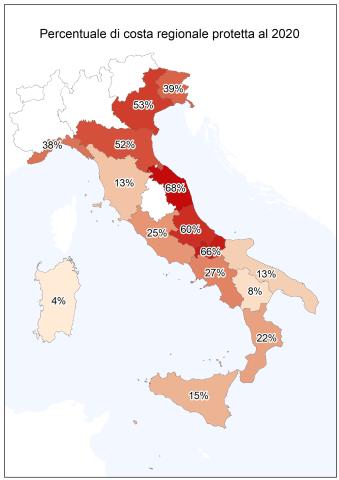
To contain the erosion of the coasts and the damage produced by the storms over the years, numerous interventions have been carried out along the Italian coasts, aimed at protecting the assets and infrastructure present in the immediate hinterland and the restoration of the backward beaches. The indicator provides an estimate on a national and regional basis of the protected coast with rigid works, the measure is representative of both the fragility of the coastal environments of the country and the management and protection costs from the hydrogeological instability of coastal areas.
18% of the Italian coasts, equal to about 1,520 km, are protected with defense works and the action to combat erosion does not stop; from the relief of the state of the coast to 2020 it appears that between 2008 and 2020 new works have been carried out to protect a further 200 km of coastline.
QUANTITATIVE STATUS OF GROUNDWATER (SQUAS)
Data aggiornamento scheda:
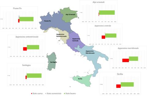
The quantitative status of groundwater describes the balance of a water body in terms of the relationship between extraction and natural replenishment of the water resource. A groundwater body is defined as being in "good quantitative status" if groundwater levels ensure that the annual average withdrawals for long-term anthropogenic activities do not exhaust the available groundwater resources, do not cause damage to surface waters and connected ecosystems, and do not lead to saline intrusion or other types of contamination.
This indicator has been derived from the classification data of water bodies in the WISE Reporting of the 3rd Water Management Plan (WMP). Nationally, during the 2016-2021 classification period under the 3rd WMP, an increase in groundwater bodies classified as being in "good quantitative status" was observed, reaching 79% of the total (compared to 61% in the 2nd WMP). The percentage of groundwater bodies in "poor" status is 19%, while 2% remain unclassified. At the district level, the percentages of water bodies achieving "good quantitative status" range from 98% in the Eastern Alps District to 58% in the Southern Apennine District.
TRANSITIONAL WATERS - BIOLOGICAL QUALITY ELEMENT BENTHIC MACROINVERTEBRATES M-AMBI-TW
Data aggiornamento scheda:
The ecological classification index of the Biological Quality Element "macroinvertebrates" for coastal lagoons, M-AMBI (Multivariate-Azti Marine Biotic Index), is based on the analysis of the structure of the macrozoobenthic community in soft sediments. It takes into account species tolerance/sensitivity, community diversity, and species richness. The M-AMBI index responds to anthropogenic pressures affecting transitional areas and describes the ecological quality status in five classes: High, Good, Moderate, Poor, and Bad.
Currently operational monitoring programs in Italian transitional waters include annual sampling on a three-year cycle: as of now, three sampling campaigns have been conducted in almost all regions since 2014. In the 2020-2022 three-year period, of the 92 transitional water bodies where the M-AMBI index was applied, 14.1% are in "High" ecological status, 32.6% in "Good," 21.7% in "Moderate," 16.3% in "Poor," and 15.2% in "Bad." Nationally, for the regions with available data (6 out of 9), 46.7% of transitional water bodies have achieved the quality goal of "Good" or "High."
TRANSITIONAL WATERS – BIOLOGICAL QUALITY ELEMENT MACROPHYTES MAQI-TW
Data aggiornamento scheda:
The MaQI (Macrophyte Quality Index) (Sfriso et al., 2014), formally adopted by Italy for the classification of the ecological status of transitional environments under Directive 2000/60/EC, integrates the two biological quality elements: macroalgae and aquatic phanerogams. The MaQI responds to anthropogenic pressures affecting transitional areas and describes the ecological quality status in five classes: high, good, moderate, poor, and bad.
The current monitoring programs in Italian transitional waters provide for two semi-annual samplings within one year of each three-year period. Since 2014, three sampling campaigns have been carried out in almost all regions. In the 2020-2022 three-year period, the MaQI index was applied to 91 Italian transitional water bodies across seven regions. Of these, 23.1% were classified as having a "high" ecological status, 23.1% as "good," 22.0% as "moderate," 28.5% as "poor," and 3.3% as "bad." Nationally, for the regions where data is available (7 out of 9), 46.2% of transitional water bodies met the quality target ("good" or "high").