Francesca Archi, Francesca Piva

The indicator provides an assessment of the chemical quality of Italian surface water bodies. The chemical status is evaluated based on the concentration of chemical substances in the water and biota matrices, specifically those listed in the Priority Substances List (Table 1/A of Legislative Decree 152/2006 and subsequent amendments). These substances are classified as priority, priority hazardous, and other substances.
For each substance in the Priority Substances List, Italian legislation—implementing European Directives—establishes Environmental Quality Standards (EQS) that must be met for a water body to be classified as having good chemical status. The chemical status, together with the ecological status, contributes to the overall “environmental status” evaluation of each water body.
The indicator was developed using classification data from the WISE Reporting of the 3rd River Basin Management Plan (RBMP). At both the national and district levels, an increase in the number of water bodies classified as having good chemical status has been observed for rivers and lakes, along with a decrease in the number of unclassified water bodies, compared to the previous cycle.
The chemical status of surface waters is evaluated based on the concentrations of chemical substances listed in Table 1/A, Annex 1, Part III of Legislative Decree 152/2006, updated by Legislative Decree 172/2015.
This list includes substances identified at the EU level as Priority or Priority Hazardous under Directive 2008/105/EC, updated by Directive 2013/39/EU, as well as other substances identified by the "daughter directives" of Directive 76/464/EEC. The list is periodically updated according to Article 16 of the Water Framework Directive (2000/60/EC).
For each substance, the legislation sets Environmental Quality Standards (EQS) for its concentration in environmental matrices where it may be detected (water or biota). The EQS values are expressed in terms of:
- Annual Average Concentration (EQS-AA)
- Maximum Allowable Concentration (EQS-MAC)
The substances monitored and considered in the chemical status assessment are selected based on available knowledge regarding the presence of anthropogenic pressures.
Sampling and analysis of substances for chemical status determination are conducted at scheduled intervals following standardized national protocols.
Based on compliance or exceedance of EQS values, a surface water body is classified as either good chemical status or not good chemical status.
"One-out, all-out" principle: If even one monitored substance exceeds the EQS limit, the water body cannot be classified as having good chemical status.
The chemical status indicator for surface waters was developed using classification data from the WISE Reporting of the 3rd RBMP. Since the Hydrographic District boundaries were redefined by Law 221/2015, to allow for comparisons between the 2nd and 3rd cycles, water bodies from the 2nd cycle were reassigned to the new district boundaries.
Every six years (at each River Basin Management Plan - RBMP), the chemical status of water bodies is assessed to verify compliance with quality requirements. Alongside ecological status, this contributes to achieving and maintaining the overall good environmental quality of water bodies. The evaluation also serves to assess the effectiveness of measures implemented and monitor progress in reducing pressures on water quality.
- Legislative Decree 152/2006 and subsequent amendments
- Legislative Decree 172/2015
- Water Framework Directive (2000/60/EC)
- Directive 2013/39/EU
- Law 221/2015
According to Legislative Decree 152/2006, implementing the Water Framework Directive (2000/60/EC), the good chemical status of surface waters is defined as the status in which the concentration of pollutants does not exceed the Environmental Quality Standards (EQS) set for the priority substances listed in Table 1/A of Annex 1, Part Three.
For substances with stricter EQS established by Directive 2013/39/EU, the target date for achieving good chemical status was December 22, 2021. However, new substances added to the priority list will not be considered in classifications until 2027.
Reporting WISE del 2° Piano di Gestione Acque dei Distretti idrografici (marzo 2017) Reporting WISE del 3° Piano di Gestione Acque dei Distretti Idrografici (aggiornamento ottobre 2022)
- District Basin Authorities
- Autonomous Provinces
- Regions
- National System for Environmental Protection (SNPA)
Data in the WISE Reporting of the 2nd Water Management Plan of Hydrographic Districts (2017) and the 3rd Management Plan (update October 2022)
- National Level
- Hydrographic Districts
2016-2021 2010-2015
Using data from the WISE Reporting databases of the 2nd and 3rd River Basin Management Plans, the number and percentage of water bodies classified as good, poor, or unclassified chemical status were calculated at both district and national levels. A comparison was made between chemical status data from the 2nd and 3rd RBMP cycles.
At both national and district levels, an overall increase has been observed in water bodies classified as having good chemical status compared to the previous cycle. Additionally, the number of unclassified water bodies has decreased.
However, some districts still show significant percentages of water bodies in poor chemical status or yet to be classified.
The current temporal coverage does not yet allow for the identification of a clear trend.
| Allegati |
|---|
Thumbnail

Titolo
Figure 1a: Chemical state of surface water bodies - rivers - 3rd cycle (2021 -2027) of Water Management Plans Fonte
ISPRA processing on WISE reporting data - monitoring 2015-2021 (October 2022 update) Legenda
PdG = Management Plan |
Thumbnail

Titolo
Figure 3a: National Chemical State of Surface Water Bodies - Rivers - Comparison 2nd Cycle (2015-2021) and 3rd Cycle (2021-2027) of Water Management Plans Fonte
ISPRA processing on WISE reporting data - monitoring 2010-2015 and 2015-2021 (October 2022 update) Legenda
PdG = Management Plan |
Thumbnail
Titolo
Figure 1b: Chemical state of surface water bodies - lakes - 3rd cycle (2021-2027) of Water Management Plans Fonte
ISPRA processing on WISE reporting data - monitoring 2015-2021 (October 2022 update) Legenda
PdG = Management Plan |
Thumbnail

Titolo
Figure 3b: National Chemical State of Surface Water Bodies - Lakes - Comparison 2nd Cycle (2015-2021) and 3rd Cycle (2021-2027) of Water Management Plans Fonte
ISPRA processing on WISE reporting data - monitoring 2010-2015 and 2015-2021 (October 2022 update) Legenda
PdG = Management Plan |
Thumbnail
Titolo
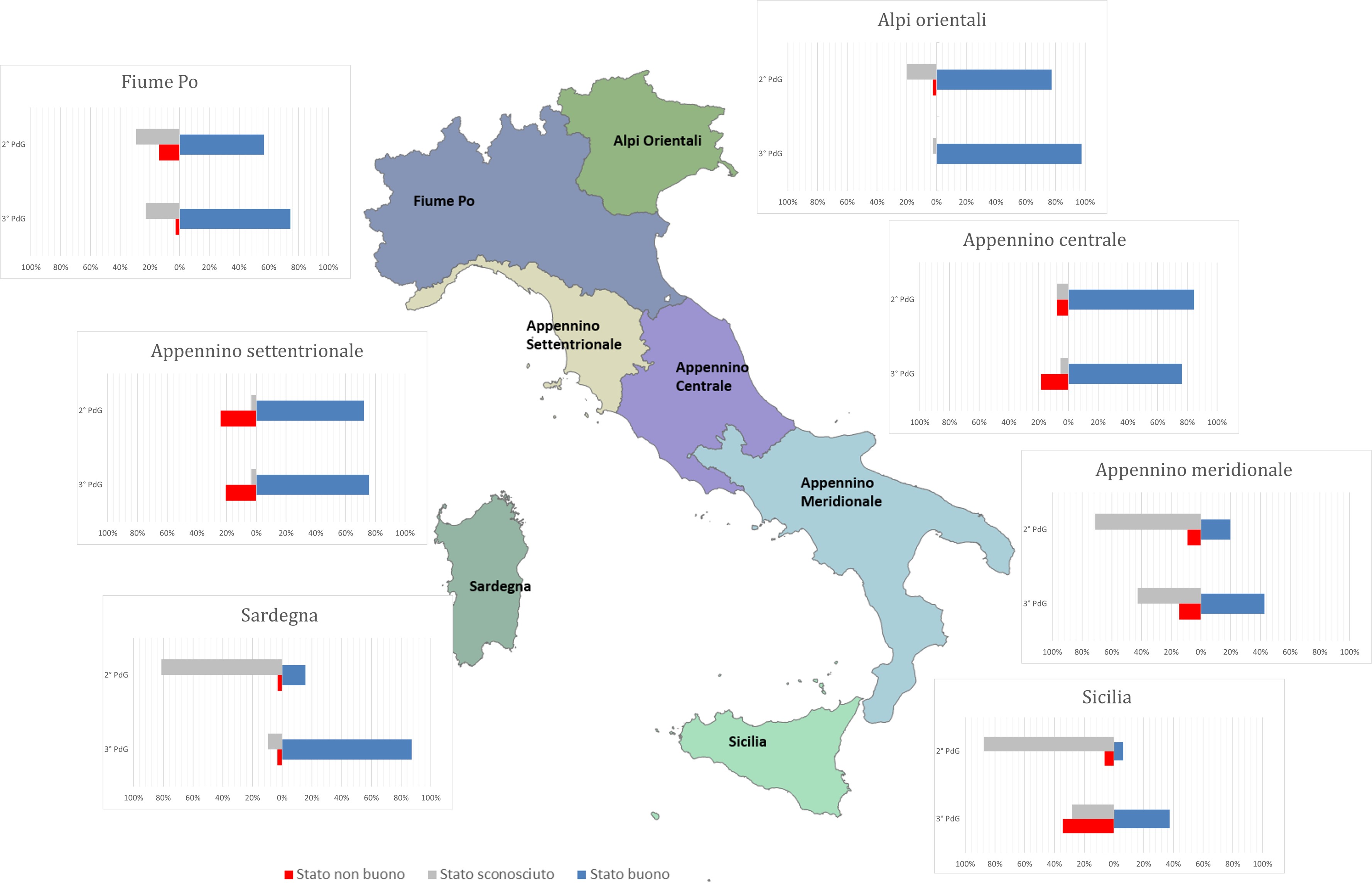
Figure 2b: Chemical state of surface water bodies – lakes - comparison 2nd cycle (2015-2021) and 3rd cycle (2021-2027) of Water Management Plans Fonte
ISPRA processing on WISE reporting data - monitoring 2010-2015 and 2015-2021 (October 2022 update) Legenda
PdG = Management Plan |
Thumbnail

Titolo
Figure 2a: Chemical state of surface water bodies - rivers - comparison 2nd cycle (2015-2021) and 3rd cycle (2021-2027) of Water Management Plans Fonte
ISPRA processing on WISE reporting data - monitoring 2010-2015 and 2015-2021 (October 2022 update) Legenda
PdG = Management Plan |
At the national level, concerning rivers (Figure 3a), there is an increase, compared to the 2nd WMP (Water Management Plan), in the water bodies classified as having good chemical status, rising to 78%, while the water bodies in poor status are at 13%. Meanwhile, the percentage of unclassified water bodies has halved, dropping to 9%. For lakes (Figure 3b), there is a significant increase in water bodies with good status, reaching 69%, while the percentage of water bodies in poor status remains essentially unchanged, and unclassified water bodies have decreased to 20%. A comparison is made between the data of the 3rd WMP and the 2nd WMP. It's worth considering that the number of water bodies has changed between the 2nd and 3rd management cycles: specifically, there were 7,493 water bodies in the river category during the 2nd WMP compared to 6,878 in the 3rd WMP. In most districts, there is an increase in river water bodies with good chemical status compared to the previous six-year period (Figure 2a), although the percentages of achieving the target vary widely among them. A slight decrease is recorded in the Po River and Central Apennines Districts, but the percentages of water bodies achieving the target in these areas still exceed the national average, standing at 83% and 87%, respectively. The most significant improvement is in the Sardinia District, where 91% of rivers reach good chemical status with all water bodies classified. In the Southern Apennines and Sicily Districts, the percentages of water bodies in good status remain below the national average, at 23% and 51%, but there is a significant increase in classified water bodies compared to the previous management cycle. Concerning lakes, there is a substantial increase in water bodies with good chemical status in almost all districts (Figure 2b), with percentages reaching 87% in the Sardinia District and 98% in the Eastern Alps District. However, in the Sicily and Southern Apennines Districts, the water bodies achieving the target do not exceed 40-45%, but the percentage of unclassified lakes has significantly decreased, in line with what has occurred, to a lesser or greater extent, in all districts.