ASTRONOMICAL TIDE HEIGHT ALONG ITALIAN COASTS
Data aggiornamento scheda: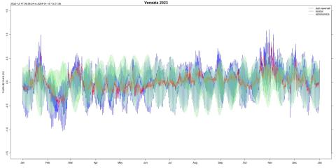
The tide is a periodic phenomenon of rising and falling sea levels caused by the gravitational attraction exerted by the Moon, the Sun, and other celestial bodies on the Earth's water masses, and secondarily by meteorological disturbances. Data from the National Tide Gauge Network (ISPRA) were used to characterize the amplitude of the astronomical component of the tidal signal along Italian coasts. As well known, astronomical tides vary significantly across the different Italian seas, reaching their maximum range in the Northern Adriatic and Venice Lagoon, being strongly influenced by the basin's configuration.
CLEAN COAST INDEX (CCI)
Data aggiornamento scheda:Any solid material, manufactured or processed by humans, abandoned or lost in the marine and coastal environment or that reaches the sea in any way is defined as marine litter. Italy, with Legislative Decree No. 190/2010 transposing the Marine Strategy Framework Directive, has been conducting an intensive marine litter monitoring program since 2015, including beach litter. Twice a year, in spring and autumn, the coastal Regional Environmental Protection Agencies (ARPA) carry out monitoring of solid waste present in sample areas of 69 reference beaches along the national coastline. To assess the cleanliness of the beaches based on the density of litter present in the monitored sample areas, the Clean Coast Index (CCI) was calculated, an indicator developed and applied internationally.
In 2023, the CCI was calculated for 69 beaches both in spring and autumn. In spring, 80% of the monitored beaches were clean or very clean compared to 12% of dirty or very dirty beaches. In autumn, 77% of the beaches were clean or very clean, while 12% were dirty or very dirty. The rest of the beaches were fairly clean. Compared to the previous year, the percentage of clean or very clean beaches increased in autumn (75% in 2022), while in spring it remained the same.
EUTROPHICATION
Data aggiornamento scheda: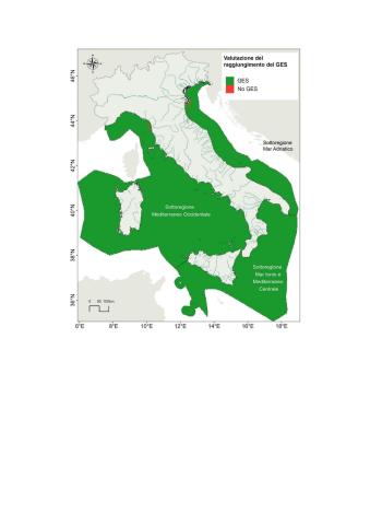
Eutrophication is a process caused by the enrichment of nutrients, particularly nitrogen and phosphorus compounds, which leads to an increase in primary production and algal biomass, resulting in the alteration of benthic communities and, in general, a decline in water quality. The input of nitrogen and phosphorus into the marine and coastal environment can originate from diffuse sources (river loads, major collectors of agricultural activity, and urban discharges) and point sources (discharges from wastewater treatment plants, industrial activities, and aquaculture operations). Objectives related to eutrophication control and management are set by the Water Framework Directive (WFD, Directive 2000/60/EC), the Marine Strategy Framework Directive (Descriptor 5, Directive 2008/56/EC), and the Nitrates Directive (Directive 91/676/EEC) and Urban Waste Water Treatment Directive (Directive 91/271/EEC), which are particularly focused on pressure management. The causes of eutrophication are primarily linked to nutrient inputs carried into the sea by rivers or coastal settlements, which cause serious negative impacts on the health of marine ecosystems and the sustainable use of goods and services. The main sources of nutrients are related to the agri-livestock and urban sectors.
Environmental assessments regarding eutrophication, in accordance with the requirements of Directive 2008/56/EC, have highlighted the achievement of Good Environmental Status. Therefore, the measures adopted so far under Directive 2000/60/EC, Directive 91/676/EEC, and Directive 91/271/EEC have proven effective in achieving environmental targets.
MARINE STRATEGY MONITORING - ALTERATION OF HYDROGRAPHIC CONDITIONS
Data aggiornamento scheda:
The monitoring provided by the Marine Strategy Framework Directive 2008/56/EC for Descriptor 7 considers the permanent alterations of hydrographic conditions due to coastal and marine infrastructures subject to national EIA, constructed or under construction or design since 2012. The reference indicator for D7C1 relates to the extent of coastal marine water bodies in each marine subregion, defined under Directive 2000/60/EC, which presents impacts due to permanent changes in hydrographic conditions due to new infrastructures constructed since 2012 and subject to national EIA. The objective for this indicator is not to exceed 5% of the extent of coastal marine water bodies. In 2023, the objective was achieved.
MARINE STRATEGY MONITORING - MICRO-LITTER IN THE SURFACE LAYER OF THE WATER COLUMN
Data aggiornamento scheda: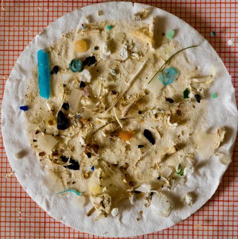
Italy, in application of the Marine Strategy Framework Directive, has implemented an extensive marine litter monitoring program since 2015, including micro-litter present in the surface layer of the water column. This monitoring is conducted by the National System for Environmental Protection (of which ISPRA is a part), under the coordination of the Ministry of Environment and Energy Security (MASE). The composition, quantity, and distribution of surface micro-litter are essential parameters for achieving the good environmental status of marine waters, the objective of the Directive. Micro-litter are particles smaller than 5 mm, whose origin is difficult to identify once dispersed in the environment. These particles derive from both primary sources, such as pellets and microbeads used in cosmetics or abrasive products, and secondary sources, such as the fragmentation of macro-litter. With the data processing carried out from 2016 to 2022, it was possible to define a median density value of micro-particles present in our seas, equal to 0.04 micro-particles per m², or 40,000 micro-particles per km². This value is confirmed by adding the 2023 data to the series. At the Mediterranean level, the Barcelona Convention has set a threshold value of 0.000845 micro-particles per m² (845 micro-particles per km²), therefore, compared to this value, Italy is still far from achieving good environmental status.
MARINE STRATEGY MONITORING – BEACH LITTER
Data aggiornamento scheda:The Marine Strategy (Directive 2008/56/EC) represents an important governance tool for the marine system, promoting the adoption of strategies aimed at safeguarding the marine ecosystem to achieve Good Environmental Status. Good Environmental Status is assessed based on 11 themes or qualitative descriptors, and among these, Descriptor 10 requires that the properties and quantities of marine litter do not cause harm to the coastal and marine environment. Since 2015, Italy has been implementing an extensive monitoring program for marine litter, including beach litter. In 2023, the median of total marine litter stranded on Italian shores was 250 items per 100 m, the lowest value in the entire historical series. However, this is still a density significantly higher than the threshold value of 20 items per 100 m, established at the European level as a requirement for achieving Good Environmental Status. As in previous years, single-use plastics are the most common type of beach litter, representing 13% of the total; however, for this type of litter, there is a sharp decline compared to 2022 (29%), which, if confirmed in the coming years, could represent a significant first result of the effectiveness of the Marine Strategy Measures Program and, in particular, the application of Directive 2019/904 for the reduction of single-use plastics.
MARINE STRATEGY MONITORING – CONTAMINANT CONCENTRATION
Data aggiornamento scheda: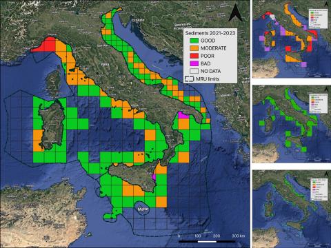
Descriptor 8 of the Marine Strategy Framework Directive 2008/56/EC (MSFD), in order to achieve good environmental status of marine waters through the gradual elimination of pollution, specifically requires the assessment of the presence of chemical contaminants and their effects in environmental matrices. During the 2021–2023 period, ISPRA conducted monitoring of the Adriatic Sea Subregion (MAD), Ionian Sea and Central Mediterranean Subregion (MIC), and Western Mediterranean Subregion (MWE). The data were processed and integrated with those provided by regional agencies and experimental zooprophylactic institutes.
This monitoring revealed that, although the data coverage for the study of contaminant concentrations varied across matrices and subregions, there was an overall improvement. This allowed for the assessment of GES (Good Environmental Status) for the sediment matrix in two MRUs and for the biota matrix in the Adriatic MRU.
UPWELLING
Data aggiornamento scheda: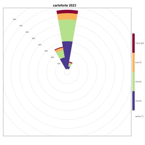
Upwelling is a physical phenomenon caused by the action of wind and currents that can generate an upwelling current, oriented offshore and perpendicular to the coast. This phenomenon has a significant impact on the local fish fauna and is therefore of great interest. The identification of the most favorable areas for the occurrence of this phenomenon has been carried out using wind speed and direction data provided by the National Tide Gauge Network (RMN) managed by ISPRA. These data, appropriately processed, allow the identification of coastal areas that are most likely to be exposed to the upwelling phenomenon, such as the Carloforte area in Sardinia, which is confirmed to be among the most favorable for the generation of this variable.