Francesca Catini, Iolanda Lisi, Valeria Pesarino
The monitoring envisaged by the Marine Strategy Framework Directive 2008/56/EC for Descriptor 7 takes into consideration the significant and permanent alterations of the hydrographic conditions due to coastal and marine infrastructures subject to national EIA, built or in the process of being designed/built since 2012. Currently the reference indicator for the D7C1 is related to the extension of coastal marine water bodies of each Sub-Region, defined pursuant to the Directive 2000/60/EC, which presents impacts due to permanent changes in hydrological conditions attributable to the presence of new infrastructures built starting from 2012 and subject to national EIA. The objective for this indicator is not to exceed 5% of the extent of coastal marine water bodies. In 2024 the goal was achieved.
In the context of Descriptor 7 (D7), the term "hydrographic conditions" refers to both the hydrological processes referable to the water column (such as: currents, bottom energy, salt and thermal regime), and the processes referable to the physiography of the seabed. Decision (EU) 2017/848 of 17 May 2017 defines the following criteria for the assessment of Good Environmental Status (GES):
- D7C1 - Secondary: Extension, in square kilometers (km 2), of the assessment area which has suffered negative effects from a hydrographic point of view.
- D7C2 - Secondary: Extent of each habitat type that has suffered adverse effects, in square kilometers (km 2) or as a percentage (%) of the total extension of the natural habitat in the assessment area.
This assessment was necessary as some hydrographic alterations can lead to the degradation of habitats of ecological and/or conservation interest (e. g. Posidonia oceanica and coral meadows) or to the establishment of conditions favorable to the triggering of events potentially impacting the quality of the environment and the uses of the sea, such as: algal blooms (including toxic ones), spread of jellyfish and increase in microbiological pollutants. During the first implementation cycle of the MSFD (2012-2018), the community working group indicated 10 years as the time period beyond which an alteration of hydrographic conditions is to be considered permanent. Therefore, works whose implementation involves an alteration of hydrographic conditions for a period of less than ten years are excluded from the impact analysis for D7. Furthermore, for the purposes of assessing the level of significance of the alteration, the analysis was limited to coastal and marine infrastructures subject to Environmental Impact Assessment procedures at national level. This made it possible to exclude coastal defense works, the construction of small ports or marinas and the expansion works of existing port infrastructures which, not being subject to a national EIA procedure, are not believed to generate significant impacts on marine ecosystems, deriving specifically from alterations in hydrographic conditions.
In particular, for the 2012-2024 evaluation period the indicator was populated considering 27 infrastructures selected including ports, regasifiers and wind farms.
Assess the impacts on bottom habitats and the water column, deriving from the alterations of hydrographic conditions induced by the construction of marine and marine-coastal infrastructures.
Framework Directive on Marine Strategy 2008/56/EC Legislative Decree 190/2010 transposing the Framework Directive on Marine Strategy 2008/56/EC Decision (EU) 2017/848 Ministerial Decree 2 February 2021 (with which the "Methodological guide for the monitoring of infrastructures subject to national EIA and potentially capable of significantly altering and permanent hydrological conditions and physiographic characteristics").
Objective of the indicator set by the Ministerial Decree of 15 February 2019 - Good Environmental Status (GES) - G 7.1: no more than 5% of the extension of coastal marine water bodies of each marine sub-region, defined pursuant to Directive 2000/60/EC, presents impacts due to permanent changes in hydrological conditions due to new infrastructures built starting from 2012 and subject to national EIA.
González D., Coughlan C., Stips A., Stolk A., González Pola C., Moreno Aranda I. M., Giorgi G., Rees J., Babbini L., Manca Zeichen M., Alenius P., Cariou V., Zervakis V., Krzyminski. W. (2015) - Review of the Commission Decision 2010/477/EU concerning MSFD criteria for assessing Good Environmental Status, Descriptor 7; EUR 27544 EN; https://doi. org/10.2788/435059
Zampoukas N.; Palialexis A.; Duffek A.; Graveland J.; Giorgi G.; Hagebro C.; Hanke G.; Korpinen S.; Tasker M.; Tornero Alvarez M.; Abaza V.; Battaglia P.; Caparis M.; Dekeling R.; Frias Vega M.; Haarich M.; Katsanevakis Stylianos M.; Klein H.; Krzyminski W.; Laamanen M.; Le Gac J.; Leppanen J.; Lips U.; Maes T.; Magaletti E.; Malcolm S.; Marques J. M.; Mihail O.; Moxon R.; O'Brien C.; Panagiotidis P.; Penna M.; Piroddi C.; Probst W. N.; Raicevich S.; Trabucco B.; Tunesi L.; Van Der Graaf S.; Weiss A.; Wernersson A.; Zevenboom W. (2014) - Technical guidance on monitoring for Marine Strategy Framework Directive, JRC, Report EUR 26499 EN http://publications. jrc. ec. europa. eu/repository/handle/JRC88073 https://doi:10.2788/70344
The assessment used only the D7C1 criterion, relating to the extension of the area, potentially affected by significant hydrographic alterations due to the presence of infrastructures, and not the D7C2 criterion, relating to the extension of the habitats, potentially impacted by the same hydrographic alterations present in the assessment area.
In order to standardize the methodology for the calculation of the areas potentially impacted by the new infrastructures subject to national EIA and relevant for the evaluation of Descriptor 7, in-depth studies are underway, in the context of agreements pursuant to art. 15, concerning the use of mathematical methods for estimating the areas in which to consider significant alterations in the hydrological conditions and physiographic characteristics", providing methodologies ad hoc for the different types of infrastructure (ports, regasifiers and wind farms).
The results on the value of the indicator are available every six years on the MSFD Report pursuant to art. 8 (marine environment assessment) of the Marine Strategy Framework Directive - 2008/56/EC, the latest version of which - Report MSFD 2024 - is accessible via the SIC - Centralized Information System of Marine Strategy - http://www. db-strategiamarina. isprambiente. it.
National
2012-2024
The extension of coastal marine water bodies of each marine sub-region affected by impacts caused by permanent changes in hydrological conditions, deriving from new infrastructures built starting from 2012 and subject to a national Environmental Impact Assessment (EIA), is calculated according to the following procedure: on an annual basis, a survey is carried out of the coastal and marine infrastructures, built or under construction or planning since 2012, which are subject to a national EIA. For each infrastructure, the extension in square kilometers (km²) of the area that presents alterations to the hydrographic conditions induced by the infrastructure itself is estimated. Subsequently, for each Sub-Region, the extensions relating to the areas potentially impacted by the present infrastructures and subject to evaluation are added. Finally, the ratio between the sum of these extensions and the overall extension of the coastal marine water bodies of the Subregion is calculated.
However, at present, the monitoring carried out by the parties proposing the 27 identified infrastructures, which can be consulted on the MASE portal dedicated to EIAs (https://va. mite. gov. it/it-IT/Procedure/ProcedureInCorso), does not follow what is strictly prescribed by the Guide. The various subjects carried out monitoring of the hydrographic conditions and made use of numerical modeling to study the wave motion and currents in a heterogeneous manner and this did not allow the evaluation method to be standardized. For these reasons, we proceeded with the evaluation of the spatial extension of the areas affected by permanent changes in hydrographic conditions through the adoption of a criterion that would allow us to proceed in a systematic manner. This criterion, with regards to port infrastructures, derives from the results of the assessment conducted on the port of Fiumicino within the EcAp-ICZM project, financed by the MATTM, which can be found in more detail in the paragraph "Assessment conducted on the port of Fiumicino within the EcAp-ICZM project". For the other types, the criterion was established through the analysis of the technical documentation included in the Environmental Impact Assessment (EIA) or Verification of EIA eligibility processes, as well as through consultation of the relevant scientific literature.
In summary, the extension of the area potentially affected by significant or permanent alterations to the hydrographic conditions, determined by the presence of the different types of infrastructure, was estimated on the basis of the following criteria:
- for ports, an area subject to permanent changes in hydrographic conditions equal to twice the surface area occupied by the infrastructure was considered.
- for regasification terminals, an impact of 1 km² was attributed for each infrastructure.
- for wind farms, an incidence equal to 0.1 times the number of wind turbines present was considered.
The value of the indicator was determined by calculating the ratio between the sum of the areas potentially affected by permanent changes in the hydrographic conditions in each marine sub-region and the overall extension of the marine-coastal water bodies of the same sub-region, as defined by Directive 2000/60/EC).
In 2024, all the marine sub-regions (Adriatic Sea, Western Mediterranean Sea, Ionian Sea and Central Mediterranean Sea) will reach the objective set by the Ministerial Decree of 15 February 2019 of Good Environmental Status (GES) (G 7.1), i. e. No more than 5% of the extension of coastal marine water bodies of each of them has impacts due to permanent changes in hydrological conditions due to new infrastructures built starting from 2012 and subject to EIA national. Specifically, the extent of these impacts for each Sub-Region is as follows: Western Mediterranean Sea 0.0229%, Ionian Sea and Central Mediterranean Sea 0.0391%, Adriatic Sea 0.5583% (Table 1).
Compared to 2023, the overall number of infrastructures considered has increased by 5 units.
The extension of the potentially impacted area does not depend on the number of infrastructures alone, but varies in relation to their type and the extension of the infrastructures themselves; consequently, the percentages of impacted area at the sub-region scale may show variations that are not proportional to the numerical increase in infrastructure. The comparison between the period 2012-2023 and the period 2012-2024 shows (Table 1):
- Western Mediterranean Sea: from 0.0930% to 0.0229% → reduction in the extension of the area potentially affected by permanent changes in hydrographic conditions, attributable to the exclusion of the new port of Fiumicino.
- Ionian Sea and Central Mediterranean Sea: from 0.033% to 0.0391% → slight increase in the extent of impacts, attributable to the inclusion of two new infrastructures in 2024.
- Adriatic Sea: from 1.4193% to 0.5583% → marked reduction in the indicator; this change is attributable to the exclusion of two infrastructures which determine a lower cumulative impact in 2024.
| Data |
|---|
Headline
Table 1: Extension of marine-coastal water bodies, in each Marine Sub-Region, affected by impacts due to permanent hydrological alterations deriving from new infrastructures built since 2012 and subject to national Environmental Impact Assessment (EIA) Data source
ISPRA processing on data from the Ministry of the Environment and Energy Security (MASE) – General Directorate for Environmental Assessments |
Thumbnail
Headline
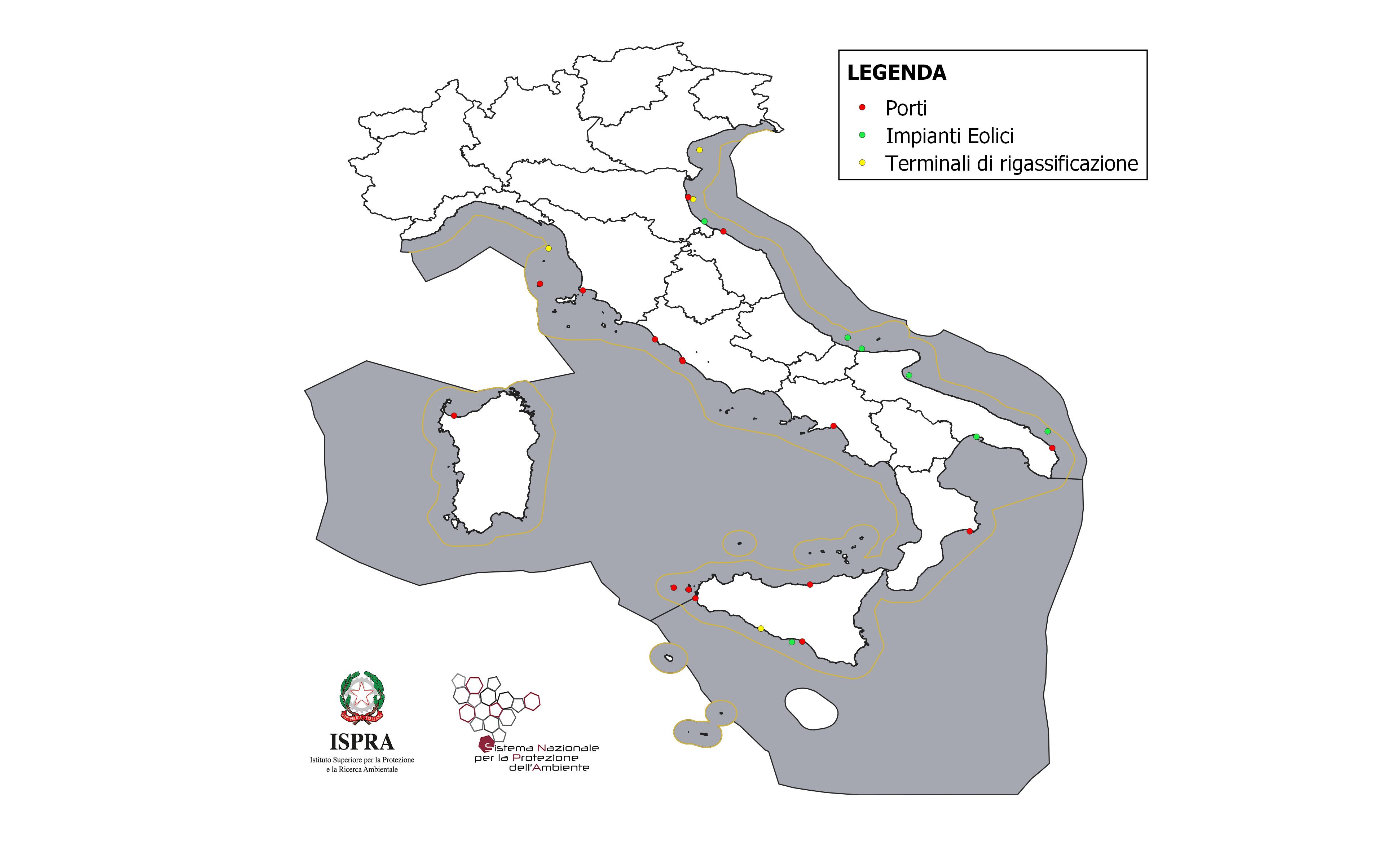
Figure 2: Location of marine and coastal marine infrastructures subject to national EIA, built, under construction or in the planning phase since 2012 Data source
ISPRA processing on data from the Ministry of the Environment and Energy Security (MASE) – General Directorate for Environmental Assessments. |
Thumbnail
Headline
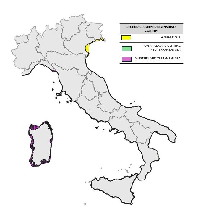
Figure 1: Marine-coastal water bodies defined pursuant to Directive 2000/60/EC (territorial waters) Data source
ISPRA processing starting from data from the Navy Hydrographic Institute (baseline) |
For the period 2012–2024, 27 marine-coastal infrastructures were considered for the purposes of defining the GES for Descriptor 7. For each marine Subregion (Table 1) the resulting value is well below the 5% threshold. Figure 2 shows the location of the 27 infrastructures considered, with an indication of the type (wind plant, regasification terminal, port).
The total of 27 infrastructures was obtained: