Andrea Bianco, Saverio Devoti, Sara Morucci, Luca Parlagreco
The tide is a periodic phenomenon of rising and falling of the sea surface due to the gravitational attraction exerted by the Moon, the Sun and other celestial bodies on the masses of water present on Earth and secondarily also due to meteorological disturbances. Data from the National Mareographic Network (ISPRA) were used to characterize the amplitude of the astronomical component of the tide signal along the Italian coasts. As is well known, the astronomical tide presents profound differences in the different Italian seas, reaching its maximum excursion in the Northern Adriatic and in the Venice Lagoon, being also strongly influenced by the configuration of the basin.
The tidal phenomenon is characterized by the rise and fall of sea level due to the gravitational attraction exerted mainly by the Moon and the Sun on the Earth's surface and, secondarily, by meteorological phenomena. Two components can therefore be distinguished, an astronomical, periodic and predictable one and a stochastic, meteorological component. The rising phase reaches its peak at the moment of maximum elevation of the sea level and is called high tide (or peak), while the minimum lowering phase is called low tide (or trough). The difference between high and low tide is called tidal range or amplitude. Tidal excursions vary in time depending on the relative position of the Earth-Sun-Moon system and in space, depending on morphological characteristics such as the depth of the seabed, the shape of the coasts and the surface of the water mass. Sea level is recorded along the Italian coasts by tide gauge stations, mainly located inside ports and managed by ISPRA. The astronomical tide was calculated using 69 harmonic constants, which take into account both the periodicities strictly linked to astronomical phenomena and the periodicities induced by meteorological phenomena. As known from the literature, for modeling application reasons only the 7 main harmonic constants can be used, especially in the Northern Adriatic and in the Venice Lagoon, where the phenomenon is more intense. Conversely, for strictly cognitive and scientific research reasons, the use of 69 harmonic constants throughout the Mediterranean is indicated.
Monitoring and characterizing the astronomical tide component along the Italian coasts can be particularly useful for the purpose of identifying any anomalies and extreme tidal phenomena compared to the natural condition of the sea, which is different at each measurement point.
It responds to the knowledge needs set out in Directive 2000/60/EC regarding coastal waters and transition waters, and to the requests of Directive 2007/60/EC regarding floods and coastal inundations. There are no objectives set by law.
ISPRA
http://dati. isprambiente. it/dataset/rmn-la-rete-mareografica-nazionale/
Italian seas
1971 - 2024
The tides in the Mediterranean Sea have a frequency of approximately 12 hours, linked to the passage of the Moon above an observation point on Earth. The tide is therefore influenced differently over the course of the month depending on the phases of the moon. This component, called astronomical, is the one that is reconstructed and presented. The measured signal, subtracted from its harmonic component, provides the residuals, which contain information on the meteorological, stochastic, phenomena that occurred.
This indicator is defined on the basis of universal constants that describe a phenomenon without characterizing any state.
This indicator is defined on the basis of universal constants, which are not expected to vary over time and therefore highlight any trend. The possible fluctuations and differences over the years can be attributed to purely stochastic phenomena and therefore the evaluation of a trend is not expected.
| Data |
|---|
Thumbnail
Headline
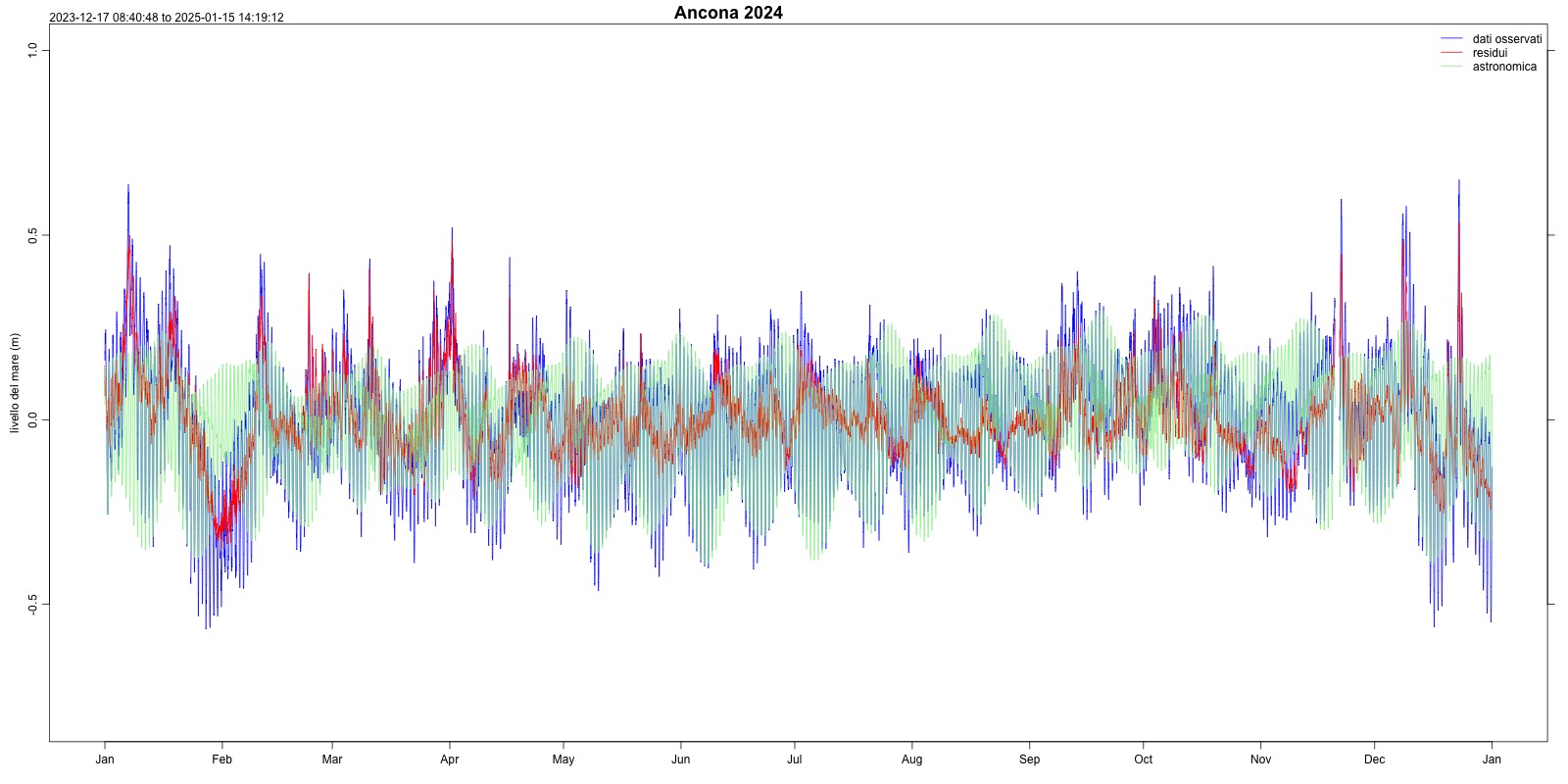
Figura 1: Astronomical tide Ancona (2024) Data source
ISPRA – National Mareographic Network (RMN) |
Thumbnail
Headline
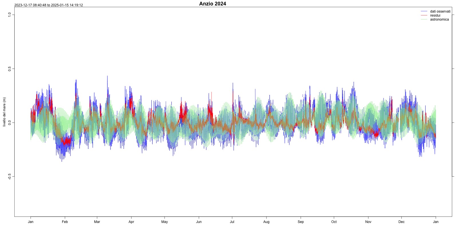
Figura 2: Astronomical tide Anzio (2024) Data source
ISPRA – National Mareographic Network (RMN) |
Thumbnail
Headline
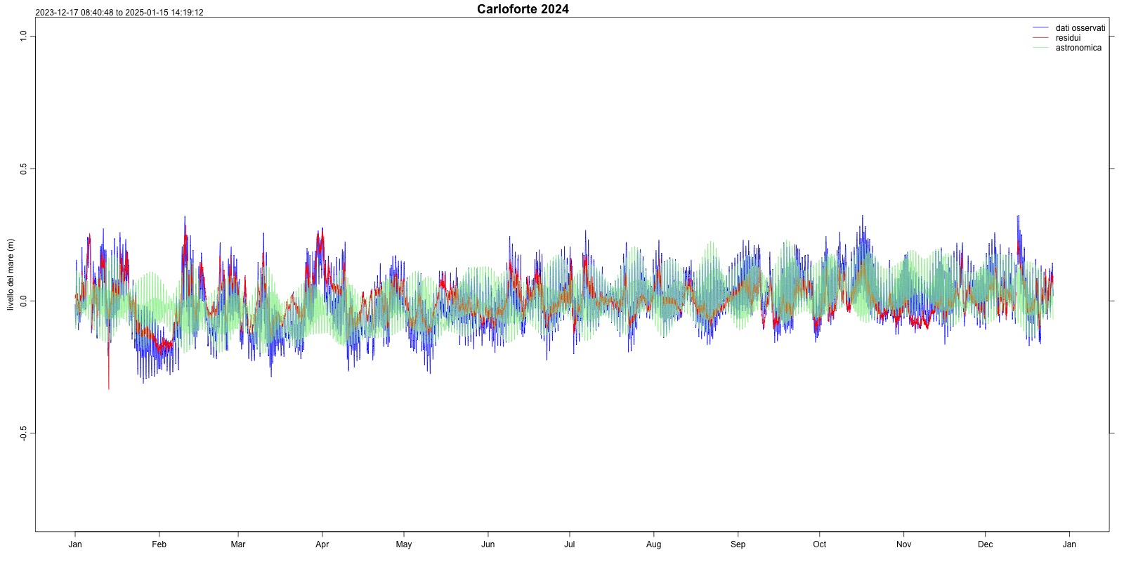
Figura 3: Astronomical tide Carloforte (2024) Data source
ISPRA – National Mareographic Network (RMN) |
Thumbnail
Headline
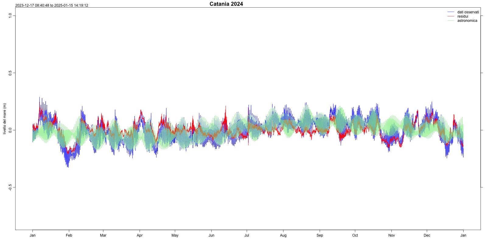
Figura 4: Astronomical tide Catania (2024) Data source
ISPRA – National Mareographic Network (RMN) |
Thumbnail
Headline
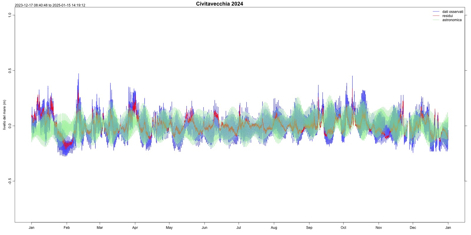
Figura 5: Astronomical tide Civitavecchia (2024) Data source
ISPRA – National Mareographic Network (RMN) |
Thumbnail
Headline
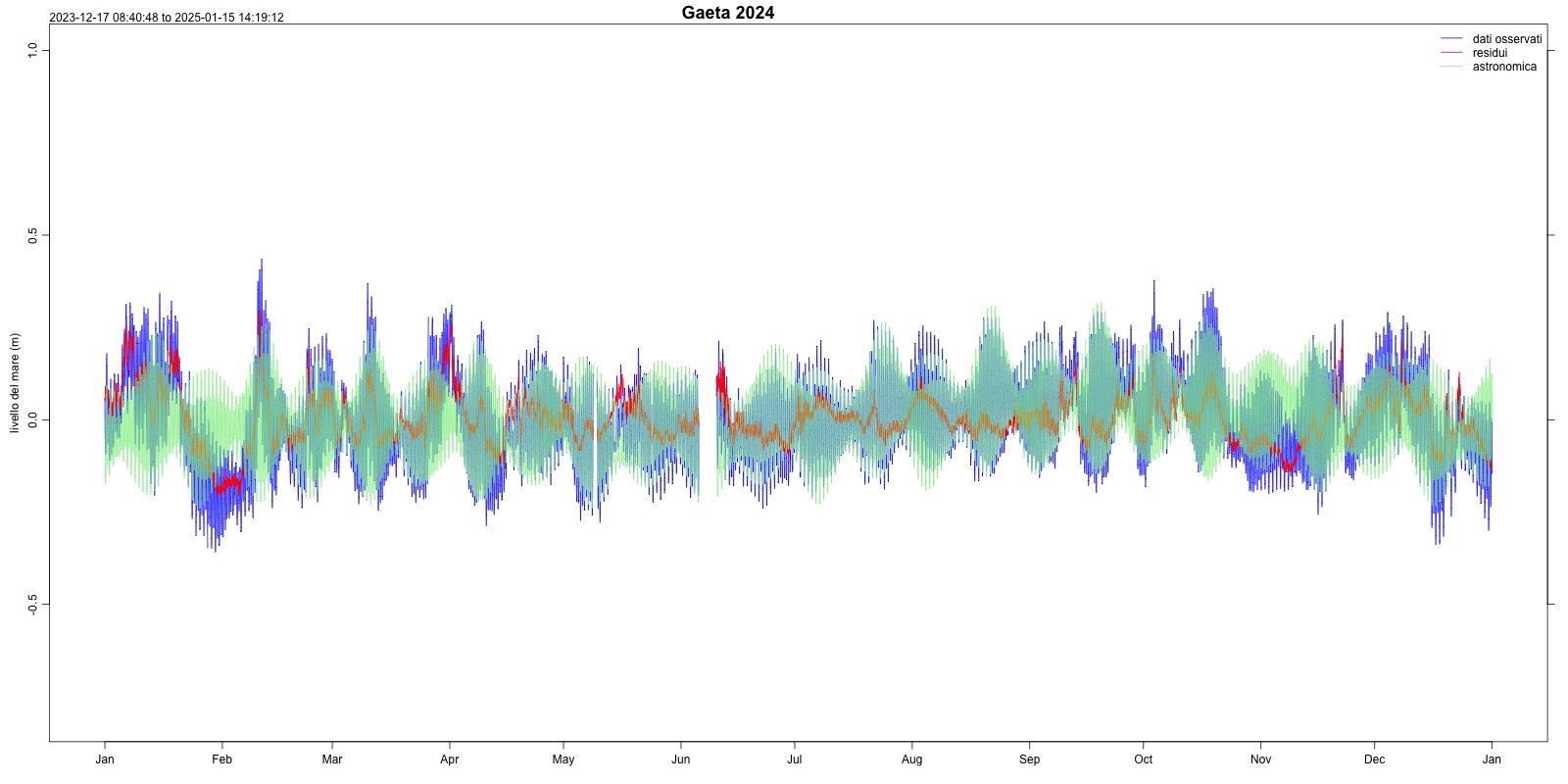
Figura 6: Astronomical tide Gaeta (2024) Data source
ISPRA – National Mareographic Network (RMN) |
Thumbnail
Headline
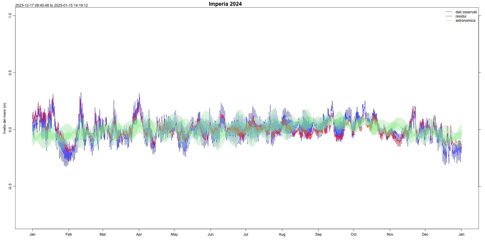
Figura 7: Astronomical tide Imperia (2024) Data source
ISPRA – National Mareographic Network (RMN) |
Thumbnail
Headline
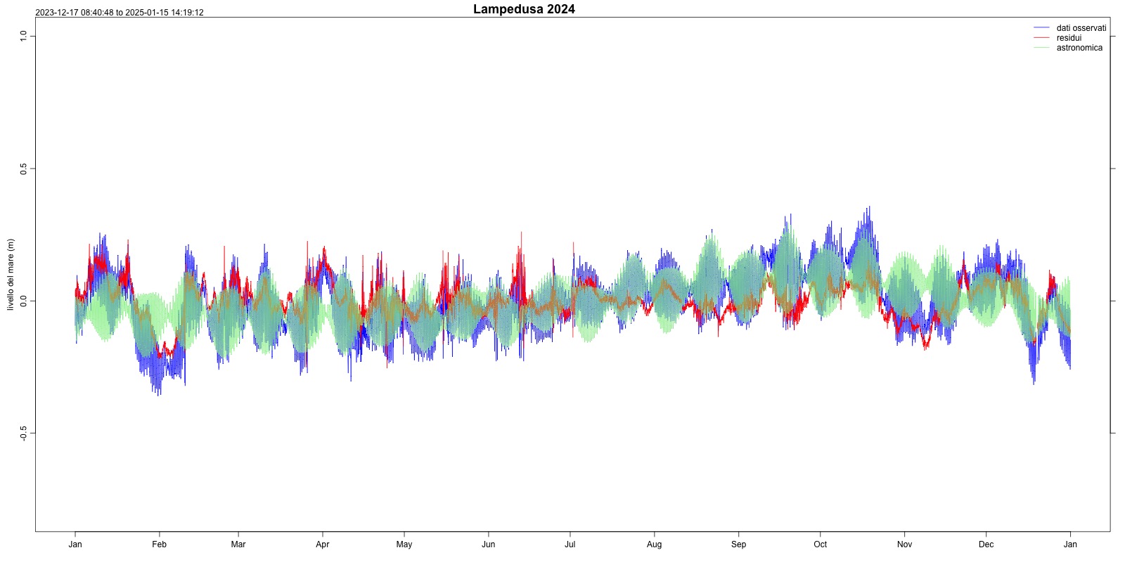
Figura 8: Astronomical tide Lampedusa (2024) Data source
ISPRA – National Mareographic Network (RMN) |
Thumbnail
Headline
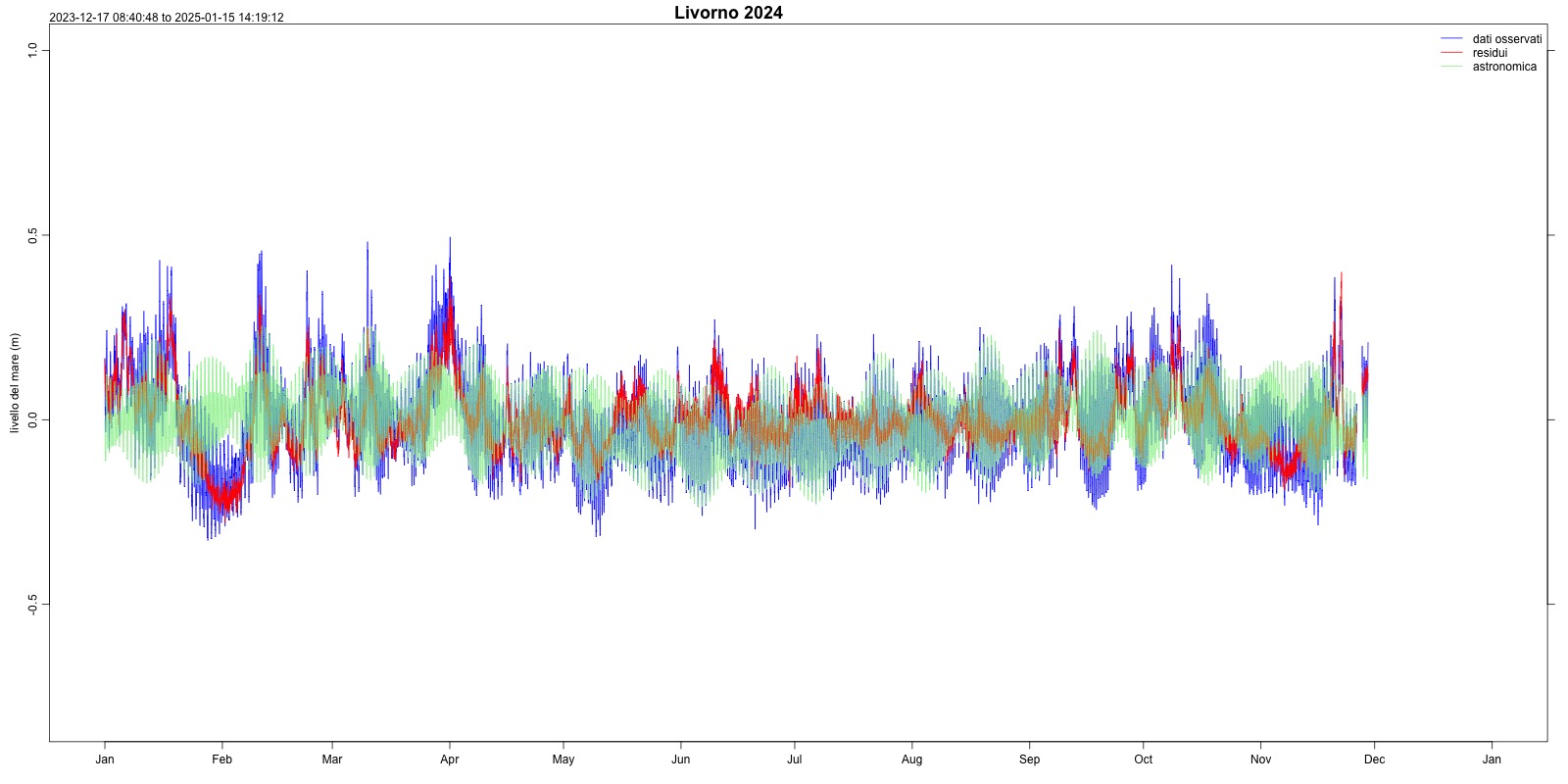
Figura 9: Astronomical tide Livorno (2024) Data source
ISPRA – National Mareographic Network (RMN) |
Thumbnail
Headline
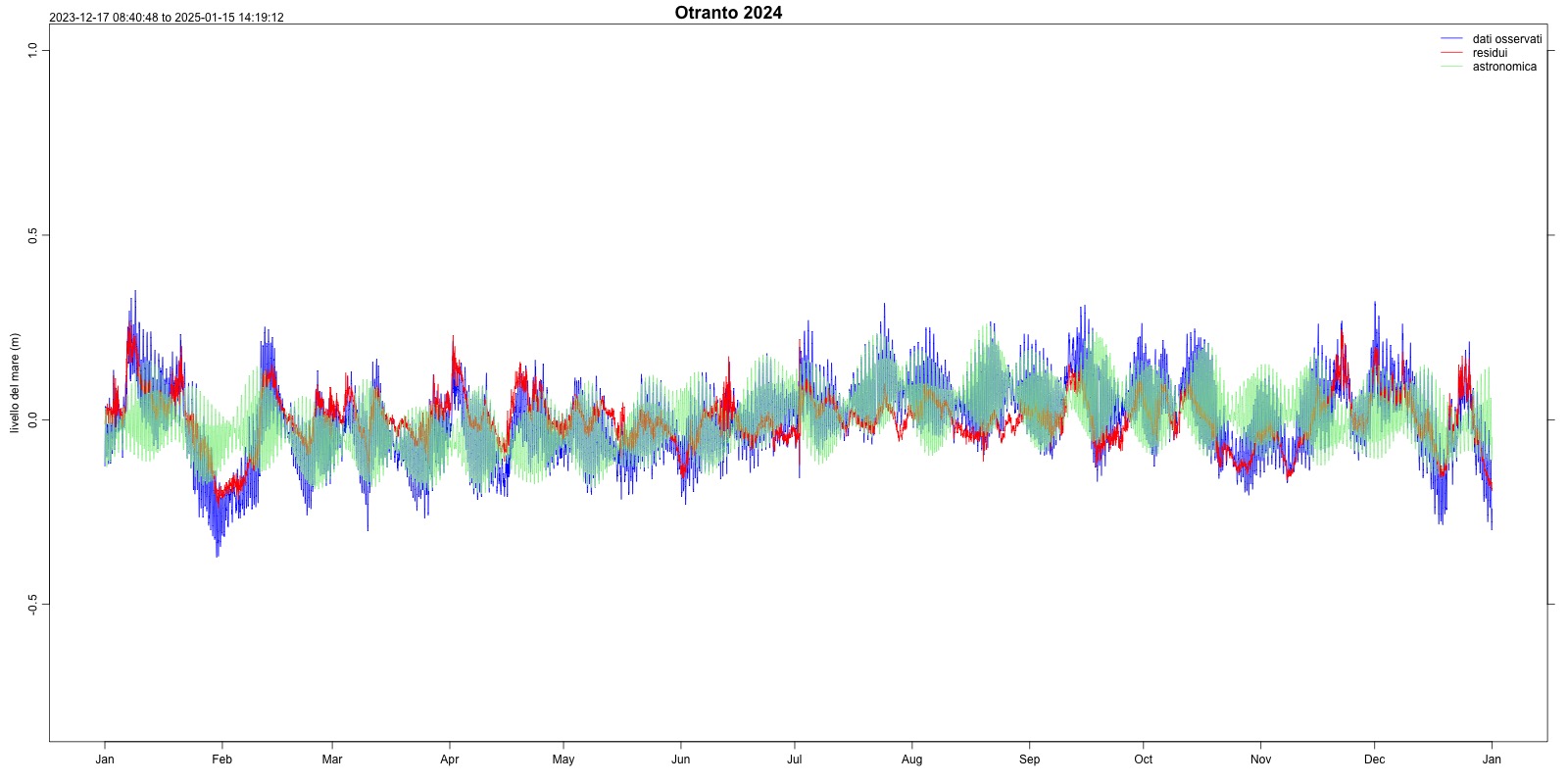
Figura 10: Astronomical tide Otranto (2024) Data source
ISPRA – National Mareographic Network (RMN) |
Thumbnail
Headline
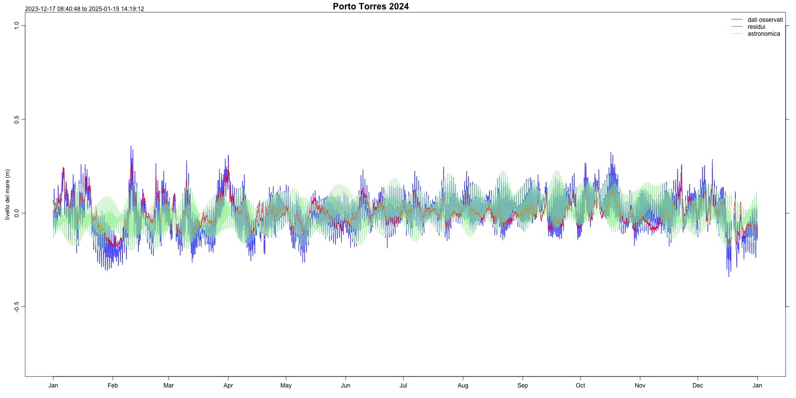
Figura 11: Astronomical tide Porto Torres (2024) Data source
ISPRA – National Mareographic Network (RMN) |
Thumbnail
Headline
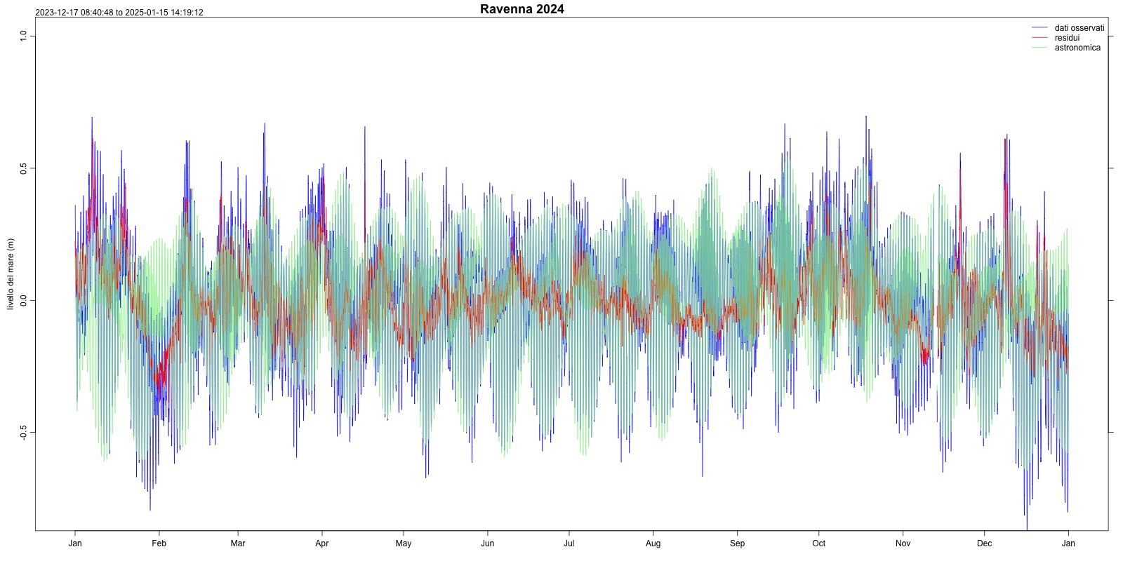
Figura 12: Astronomical tide Ravenna (2024) Data source
ISPRA – National Mareographic Network (RMN) |
Thumbnail
Headline
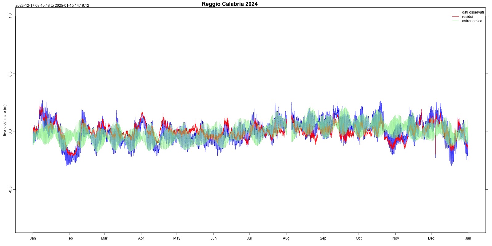
Figura 13: Astronomical tide Reggio Calabria (2024) Data source
ISPRA – National Mareographic Network (RMN) |
Thumbnail
Headline
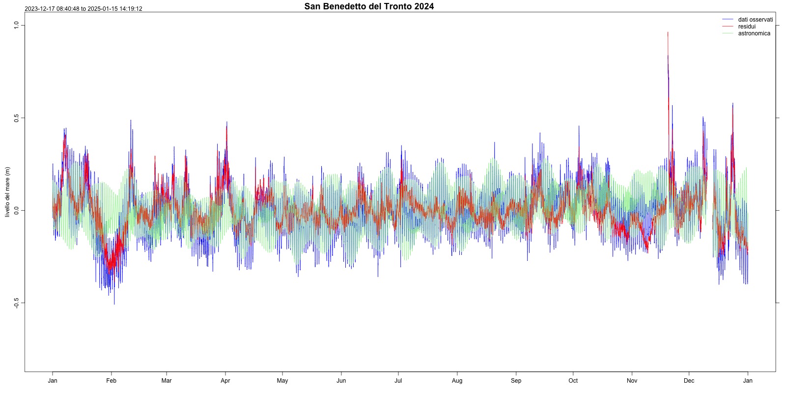
Figura 14: Astronomical tide San Benedetto del Tronto (2024) Data source
ISPRA – National Mareographic Network (RMN) |
Thumbnail
Headline
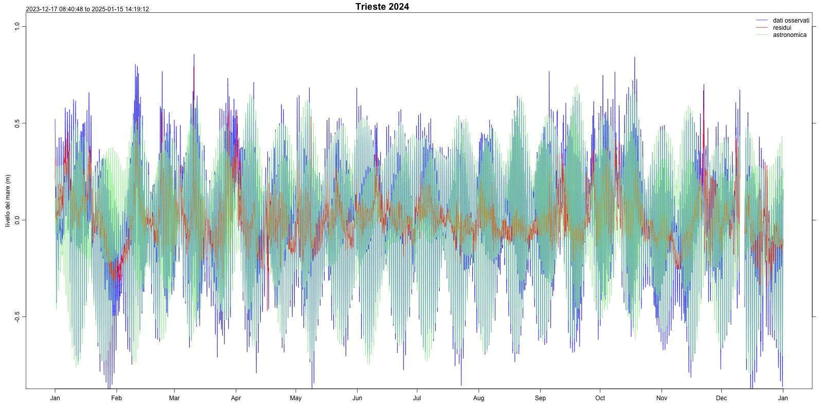
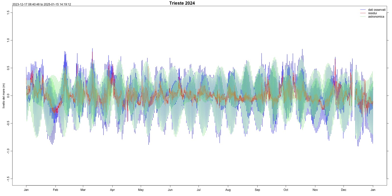
Figura 15: Astronomical tide Trieste (2024) Data source
ISPRA – National Mareographic Network (RMN) |
Thumbnail
Headline
Figura 16: Astronomical tide Trieste zoom (2024) Data source
ISPRA – National Mareographic Network (RMN) |
Thumbnail
Headline
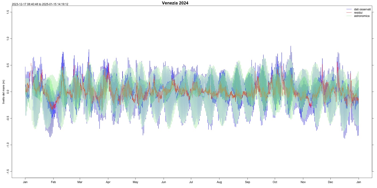
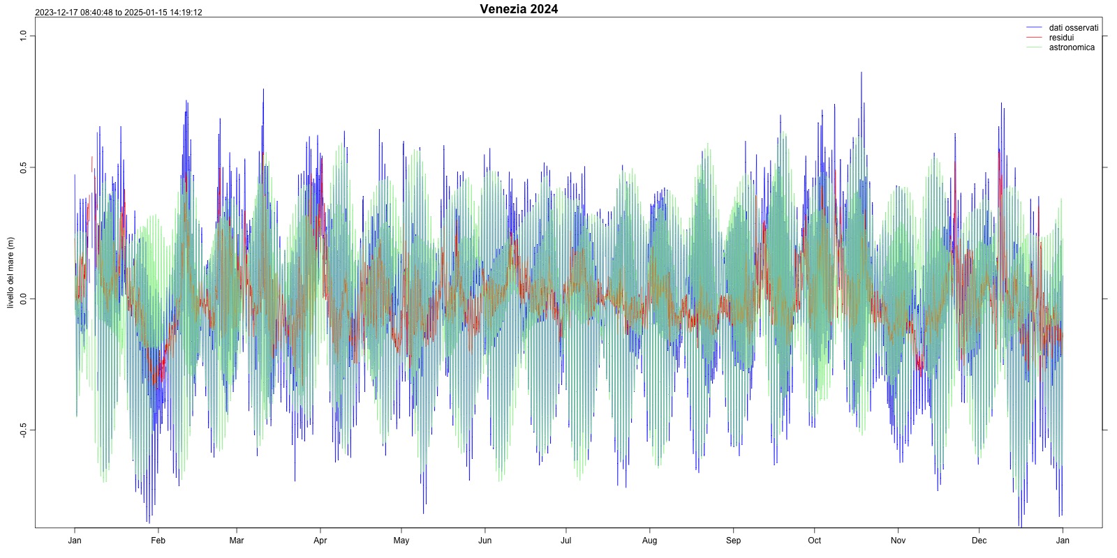
Figura 17: Astronomical tide Venezia (2024) Data source
ISPRA – National Mareographic Network (RMN) |
Thumbnail
Headline
Figura 18: Astronomical tide Venezia zoom (2024) Data source
ISPRA – National Mareographic Network (RMN) |
Thumbnail
Headline
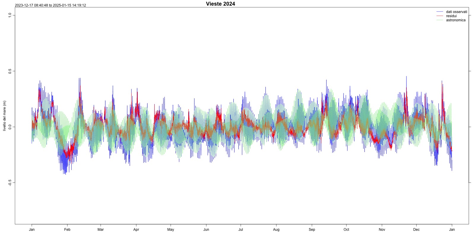
Figura 19: Astronomical tide Vieste (2024) Data source
ISPRA – National Mareographic Network (RMN) |
Headline
Table 1: Astronomical tide along the Italian coasts (2024) Data source
ISPRA - National Mareographic Network |
The indicator refers to 2024 and is presented with the aim of uniformly characterizing, along the Italian coasts, the locally expected astronomical tide, updating and updating its values compared to the observed data. As can be highlighted from the analyzes of the stations of Trieste and Venice, and as is well known, the level of the astronomical tide presents decidedly higher values in the Northern Adriatic (Venice and Trieste), with tidal maximums and minimums almost three times those recorded in other measuring stations (Tyrrhenian Sea) (Table 1). This can be seen in Figures 15, 16, 17, 18, both for the Venice and Trieste stations; Figures 15 and 17 represent the trend of the astronomical tide on the same scale as the other Italian stations, in order to highlight the greater intensity of the phenomenon (and their out-of-scale nature), and Figures 16 and 18 instead represent, on the appropriate scale, the astronomical tide in its entirety. The intense effect of the tide in the Venice Lagoon is well known, which is also reflected in the data presented in this indicator. The time series of approximately 50 years (1971-2024) allow us to study in detail any oscillations of the astronomical components of the tide, mainly due to stochastic phenomena, and to monitor their substantial stability over time, as expected from the physical phenomenon that governs them. Furthermore, the availability of data distributed along all the Italian coasts allows a precise evaluation of the astronomical phenomenon, of extraordinary interest and usefulness also in the operational forecasting field.