DREDGED SEDIMENTARY SANDS FOR BEACH NOURISHMENT PURPOSES
Data aggiornamento scheda: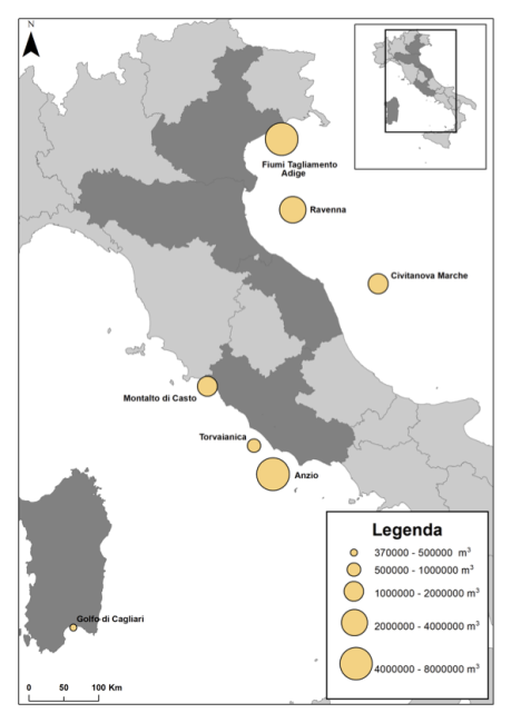
In Italy, the coasts, which develop for over 8,000 km, represent an important strategic resource: they are among the most densely populated areas and home to intense economic activity. The increasing exploitation to which these areas are subjected, associated with natural events (e.g. global climate change), has led to an increase in erosion phenomena. To counteract these processes and to protect housing and infrastructure, over the years numerous rigid defense works have been carried out in several coastal regions (surfaces emerged, submerged, grazing, mixed works, piers, brushes), not always with satisfactory results. An alternative technique that could guarantee a good response to coastal erosion, from an environmental and economic point of view, is replenishment. The replenishment consists in reconstructing the eroded beach by entering suitable sediments (from the granulometric and compositional point of view). A possible response to the need to supply material to be used for replenishment has been identified in the use of relict marine sands (referenced to paleopiagge) from sandy deposits present offshore on the continental shelf. The first dredging of rewashed sands for replenishment began in 1995 in the northern Adriatic Sea (Veneto). Subsequently, other dredgings have affected both other quarries located in the Adriatic Sea (off Emilia-Romagna and Marche) and both quarries located in the Tyrrhenian Sea (off the coast of Sardinia and Lazio).
ECOLOGICAL STATUS OF COASTAL MARINE WATERS
Data aggiornamento scheda: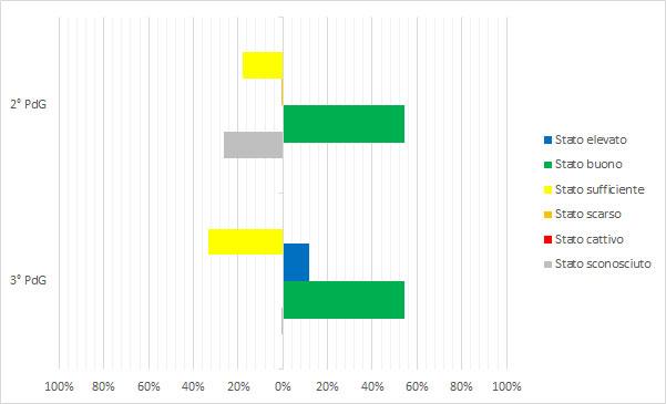
Coastal marine waters are defined as “surface waters situated inside an imaginary line one nautical mile away, at every point, on the outer side from the nearest point of the baseline used to define the territorial sea limit, and potentially extending to the outer boundary of transitional waters.” The legislation (Legislative Decree 152/2006) mandates achieving "good" status (ecological + chemical) for water bodies by the deadlines set by current regulations; failure to meet environmental goals entails remediation measures. Based on the analysis of data reported by Districts in the 3rd Reporting to the European Commission for the six-year period 2016–2021 (3rd WMP), the ecological status of Italian coastal marine waters is heterogeneous. This heterogeneity is expressed in both the number of water bodies identified per district and their ecological classification. The Eastern Alps, Northern Apennines, Central Apennines, Sicily, and Sardinia Districts show a percentage of water bodies in good and high ecological status greater than or equal to 70%. Specifically, in the Sardinia District, more than 40% of water bodies are in high status. Nationally, more than 60% of water bodies (261 out of 394 total) are in good and high ecological status. Comparing data from the 2nd WMP and the 3rd WMP shows that in the 2nd WMP, 27% of water bodies had unknown ecological status (149 out of 561 total), while in the 3rd WMP, only one water body is in unknown ecological status. In general terms, the proportion of water bodies in good and high ecological status increased from 55% in the 2nd WMP to 66% in the 3rd WMP.
ECOLOGICAL STATUS OF INLAND SURFACE WATERS
Data aggiornamento scheda: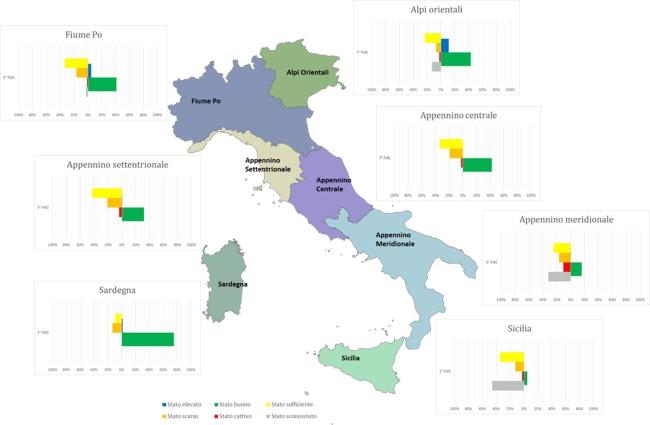
The ecological status of surface waters reflects the quality of the structure and functioning of aquatic ecosystems. Directive 2000/60/EC (transposed in Italy with Legislative Decree 152/2006) mandates the achievement of "good" quality status for water bodies, which is determined by the assessment of both ecological and chemical status. The indicator provides an evaluation of the ecological status of surface water bodies—specifically inland waters—based on classification data from the WISE 2022 Reporting related to the 3rd Water Management Plan. At the national level, comparing the ecological quality status data between the 2nd and 3rd Management Plans shows a reduction in water bodies with unknown status, from 18% to 10%, though they are still present. In general, the ecological status has not significantly changed from the previous management cycle, except for the percentage of lakes in good status, which has increased from 17% to 35%.
ECOLOGICAL STATUS OF TRANSITIONAL WATERS
Data aggiornamento scheda: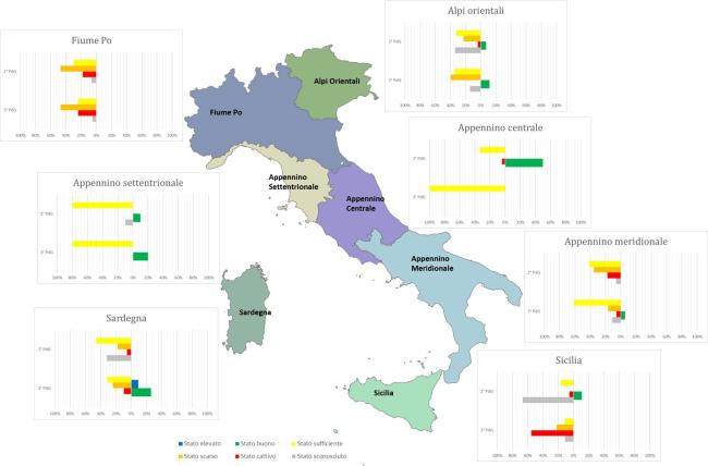
Transitional waters are defined in Legislative Decree 152/2006 as "surface water bodies near a river mouth, partially saline due to their proximity to coastal waters but significantly influenced by freshwater flows." This definition encompasses coastal lagoons and coastal ponds subject to ecological classification. Italian transitional environments are exposed to numerous pressure factors, often leading to degradation of ecological conditions in these fragile ecosystems. The ecological status analysis shows heterogeneous values, both in the number of Water Bodies (WB) and in the distribution across quality classes, with a prevalence of sufficient and poor statuses in all Districts. Comparing the status of the 2nd Water Management Plan (WMP) cycle with that of the 3rd cycle, it is observed that for all hydrographic districts, ecological status remains predominantly sufficient and poor. However, there is an increase in the percentage of water bodies in good status in the Eastern Alps District (from 7% to 11%), Northern Apennines District (from 10% to 20%), Southern Apennines District (from 0% to 6%), and Sardinia District (from 0% to 26%). National analysis of ecological status shows that the number of water bodies in good or high status increased from 9 out of 172 (5%) in the 2nd WMP cycle to 22 out of 146 (15%) in the 3rd cycle.
FLOWS
Data aggiornamento scheda:The indicator provides an assessment of the trend of water volumes measured in bedside sections of some of the main Italian watercourses compared to the year and the previous decade. For 2021 it was possible to represent the data of scope for 6 sections of closure of as many waterways of national importance (Po, Arno, Adige, Bacchiglione, Serchio and Tiber). In 2021, the annual volumes drained in the measurement sections showed significant increases compared to 2020, with increases of between 6% and 25%, with the exception of the sections on the Adige and the Po.
M-AMBI IN THE VENETIAN LAGOON (BENTHIC MACROINVERTEBRATES)
Data aggiornamento scheda: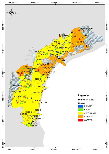
The Ecological Classification Index of the Macroinvertebrate Biological Quality Elementary for Coastal Lagoons, M-AMBI (Multivariate-Azti Marine Biotic Index), is based on the analysis of the structure of the mobile macrozoobentonic community and takes into account the tolerance/sensitivity of species, community diversity and specific wealth. The M-AMBI index responds to anthropogenic and natural pressures affecting transition areas and describes the ecological quality status in 5 classes: high, good, sufficient, scarce and bad.
The monitoring of benthic macroinvertebrates for the application of the M-AMBI index has been active in the Venice Lagoon since 2011 with a three-year frequency. In the 12 years of monitoring, 4 sampling campaigns were carried out; in 2022 four water bodies out of eleven are in a “poor” state, the remaining in a “sufficient” state and the trend of comparison between all the years of monitoring is stable.
MAIN MEASURES FOR WATER BODIES
Data aggiornamento scheda: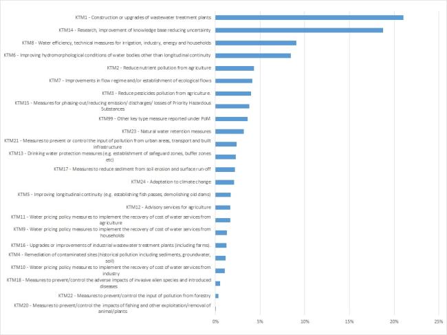
The Water Framework Directive (WFD) - Directive 2000/60/EC - requires that for each river basin district, within the River Basin Management Plan (RBMP), also known as the Water Management Plan (WMP), a "Program of Measures" (PoM) is established. This program, based on the analyses carried out, should enable the achievement of environmental objectives set by the directive (a "good" status for natural water bodies; a "good" potential for heavily modified or artificial water bodies) by 2015. Environmental quality objectives can be exempted or extended in specific cases explicitly provided for by the WFD.
The WFD distinguishes between "basic measures" and "supplementary measures." The former essentially consist of applying measures required by other specific directives (e.g. Nitrates Directive, Habitats Directive) and are listed in Part A of Annex VI of the WFD; the latter are additional measures (e.g. river restoration, knowledge enhancement, fiscal tools) and are included in Part B of Annex VI in a non-exhaustive list.
Given the variety and level of detail of the measures, for reporting purposes, the measures in the PoM are grouped into 25 macro-categories, the "Key-Type of Measures" (KTM). Each KTM serves to mitigate the impact of one or more pressures, and it is possible to link them to each other. In other words, for each KTM, the percentage of significant pressure types these measures aim to mitigate can be represented.
The processed information comes from the six-yearly reporting of Water Management Plans prepared by the district basin authorities as required by the Water Framework Directive -2000/60/EC. The data refer to the period 2010–2015.
MAQI LAGOON OF VENICE (MACROPHYTE QUALITY INDEX)
Data aggiornamento scheda: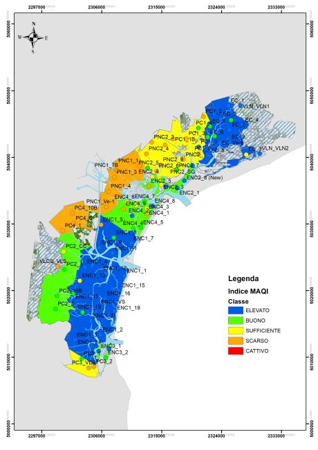
The MaQI (Macrophyte Quality Index) (Sfriso et al., 2014) formally adopted by Italy for the classification of the ecological status of transition environments under Directive 2000/60/EC, integrates the two organic quality elements macroalgae and aquatatal fanerogages.
The MaQI responds to anthropogenic pressures affecting transition areas and describes the ecological quality status in 5 classes: high, good, sufficient, scarce and bad.
The monitoring of macrophytes for the application of the MaQI index has been active in the Venice Lagoon since 2011 with a three-year frequency. In the three-year period 2020-2022 (21 data) of the eleven natural water bodies of the Venice Lagoon, two were in a “high” state, four in a “good” state, three “sufficient” and two in a “poor” state. The trend, although statistically not significant, is overall positive, considering the improvement of the state of some bodies of water.
MARINE STRATEGY MONITORING - PHYSICAL LOSS
Data aggiornamento scheda: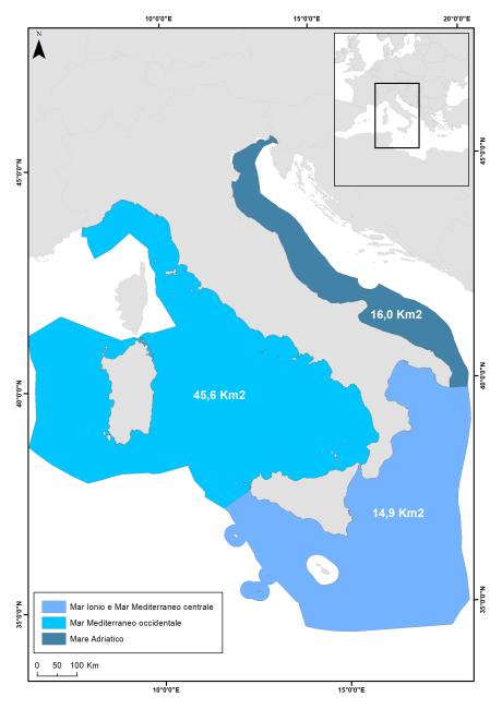
Physical loss defines the surface area of the seabed lost due to permanent modifications of the substrate and/or seabed morphology induced by anthropogenic activities and/or works, such as coastal defense works, port infrastructures, cables and pipelines, etc. It contributes to defining the level of seabed integrity, as defined under the Marine Strategy Framework Directive (2008/56/EC) and Decision (EU) 2017/848; the Directive is based on an integrated approach and aims for Member States to achieve good environmental status (GES) for their marine waters. Physical loss is calculated for the three Marine Reporting Units (MRUs) under Italian jurisdiction: "Adriatic Sea," "Ionian Sea and Central Mediterranean," and "Western Mediterranean Sea." For the initial population of the "physical loss" indicator, data updated to 2021 are used, i.e., the most recent available data for each type of work; these data will constitute the baseline for future populations. The physical loss indicator allows evaluating both the total extent of the studied phenomenon and the incidence of different types of works and/or activities on the total physical loss; it also assesses the incidence and distribution of physical loss in relation to different habitat types (Broad Habitat Types and Other Habitat Types sensu MSFD) present in Italian seas.
NITRATES IN GROUNDWATER
Data aggiornamento scheda:The indicator provides the percentage of groundwater monitoring stations divided into quality classes based on the average nitrate concentration recorded over a four-year monitoring period (2016–2019). Specifically:
- 68.1% of stations show an average nitrate concentration below 25 mg/L,
- Only 12.6% of monitored points recorded an average concentration equal to or above 50 mg/L.
Additionally, an analysis comparing the trend over the last four years (2016–2019) to the previous four years (2012–2015) reveals predominantly stable nitrate concentrations, a decrease in average concentration at 37.9% of common stations between the two periods, and an increase at only 22.7% of the same stations.
PRESSURES ON WATER BODIES
Data aggiornamento scheda: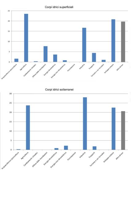
The indicator provides a nationwide picture of the types of pressures acting on surface and groundwater bodies. This information comes from the reporting of the Water Management Plans drawn up by the District Basin Authorities in accordance with the Water Framework Directive 2000/60/EC. The data refer to the six-year period 2010-2015.
PROTECTED COASTLINE
Data aggiornamento scheda: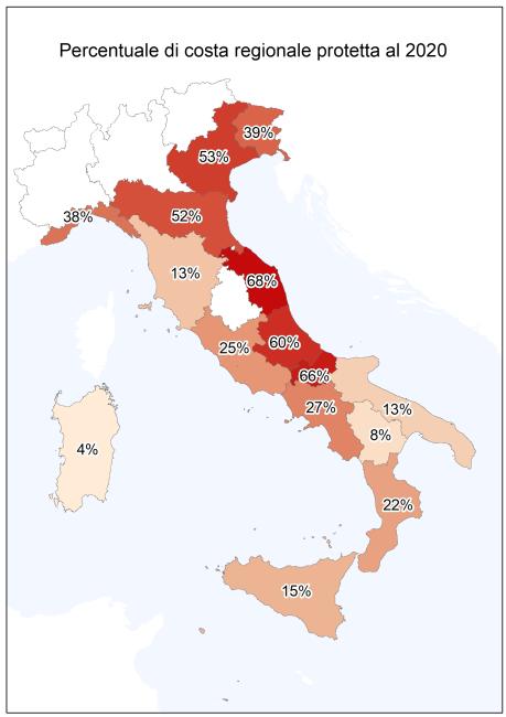
To contain the erosion of the coasts and the damage produced by the storms over the years, numerous interventions have been carried out along the Italian coasts, aimed at protecting the assets and infrastructure present in the immediate hinterland and the restoration of the backward beaches. The indicator provides an estimate on a national and regional basis of the protected coast with rigid works, the measure is representative of both the fragility of the coastal environments of the country and the management and protection costs from the hydrogeological instability of coastal areas.
18% of the Italian coasts, equal to about 1,520 km, are protected with defense works and the action to combat erosion does not stop; from the relief of the state of the coast to 2020 it appears that between 2008 and 2020 new works have been carried out to protect a further 200 km of coastline.
QUANTITATIVE STATUS OF GROUNDWATER (SQUAS)
Data aggiornamento scheda: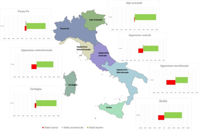
The quantitative status of groundwater describes the balance of a water body in terms of the relationship between extraction and natural replenishment of the water resource. A groundwater body is defined as being in "good quantitative status" if groundwater levels ensure that the annual average withdrawals for long-term anthropogenic activities do not exhaust the available groundwater resources, do not cause damage to surface waters and connected ecosystems, and do not lead to saline intrusion or other types of contamination.
This indicator has been derived from the classification data of water bodies in the WISE Reporting of the 3rd Water Management Plan (WMP). Nationally, during the 2016-2021 classification period under the 3rd WMP, an increase in groundwater bodies classified as being in "good quantitative status" was observed, reaching 79% of the total (compared to 61% in the 2nd WMP). The percentage of groundwater bodies in "poor" status is 19%, while 2% remain unclassified. At the district level, the percentages of water bodies achieving "good quantitative status" range from 98% in the Eastern Alps District to 58% in the Southern Apennine District.
TRANSITIONAL WATERS - BIOLOGICAL QUALITY ELEMENT BENTHIC MACROINVERTEBRATES M-AMBI-TW
Data aggiornamento scheda:
The ecological classification index of the Biological Quality Element "macroinvertebrates" for coastal lagoons, M-AMBI (Multivariate-Azti Marine Biotic Index), is based on the analysis of the structure of the macrozoobenthic community in soft sediments. It takes into account species tolerance/sensitivity, community diversity, and species richness. The M-AMBI index responds to anthropogenic pressures affecting transitional areas and describes the ecological quality status in five classes: High, Good, Moderate, Poor, and Bad.
Currently operational monitoring programs in Italian transitional waters include annual sampling on a three-year cycle: as of now, three sampling campaigns have been conducted in almost all regions since 2014. In the 2020-2022 three-year period, of the 92 transitional water bodies where the M-AMBI index was applied, 14.1% are in "High" ecological status, 32.6% in "Good," 21.7% in "Moderate," 16.3% in "Poor," and 15.2% in "Bad." Nationally, for the regions with available data (6 out of 9), 46.7% of transitional water bodies have achieved the quality goal of "Good" or "High."
TRANSITIONAL WATERS – BIOLOGICAL QUALITY ELEMENT MACROPHYTES MAQI-TW
Data aggiornamento scheda:
The MaQI (Macrophyte Quality Index) (Sfriso et al., 2014), formally adopted by Italy for the classification of the ecological status of transitional environments under Directive 2000/60/EC, integrates the two biological quality elements: macroalgae and aquatic phanerogams. The MaQI responds to anthropogenic pressures affecting transitional areas and describes the ecological quality status in five classes: high, good, moderate, poor, and bad.
The current monitoring programs in Italian transitional waters provide for two semi-annual samplings within one year of each three-year period. Since 2014, three sampling campaigns have been carried out in almost all regions. In the 2020-2022 three-year period, the MaQI index was applied to 91 Italian transitional water bodies across seven regions. Of these, 23.1% were classified as having a "high" ecological status, 23.1% as "good," 22.0% as "moderate," 28.5% as "poor," and 3.3% as "bad." Nationally, for the regions where data is available (7 out of 9), 46.2% of transitional water bodies met the quality target ("good" or "high").