Panel 1
Francesca Piva
The indicator provides a nationwide picture of the types of pressures acting on surface and groundwater bodies. This information comes from the reporting of the Water Management Plans drawn up by the District Basin Authorities in accordance with the Water Framework Directive 2000/60/EC. The data refer to the six-year period 2010-2015.
The indicator describes the types of significant pressure on surface and groundwater bodies. A pressure is defined as ‘significant’ if by itself, or in combination with others, it contributes to an impact (a deterioration in status) that may jeopardise the achievement of the environmental objectives set out in Article 4(1) of Directive 2000/60/EC, which include achieving good status, not deteriorating status, preventing an upward trend in groundwater pollution and achieving the objectives for protected areas.
The list of pressure types, and their determinants, that were examined refer to WFD Reporting Guidance 2016, Annex 1, the European Commission guideline, which includes technical specifications for reporting information contained in Water Management Plans.
The identification of significant pressures on water bodies is one of the initial steps in the planning process required by Directive 2000/60/EC. The resulting risk assessment is used to design monitoring programmes whose purpose is to determine the status and validate the risk analysis.
Water Framework Directive 2000/60/EC
Legislative Decree 152/2006
The identification of the significant pressures and consequent impacts is provided for by art. 5 of Directive 2000/60/EC and by the Italian rule of transposition Legislative Decree no. 152 of 3 April 2006 on “Environmental rules” and must be contained in the Water Management Plans as necessary to assess the achievement of the environmental objectives dictated by the aforementioned standards.
Panel 2
CIS Guidance no.3 - Analysis of Pressures and Impacts
WFD reporting Guidance 2016
Water Framework Directive 2000/60/EC
Legislative Decree 152/2006
District Management Plans - analysis of pressures and impacts
Not being available at present a guideline that defines the criteria for the identification of significant pressures, the characterization of pressures carried out by the District Basin Authorities presents inhomogeneities that affect the comparability of the results.
As part of the SNPA, a Working Group (GdL - Pressures) has been established, which is developing a National Guideline for the definition of indicators, and related thresholds, concerning significant pressures. The availability of guidelines on the analysis and identification of significant pressures will reduce the heterogeneity of the methodologies adopted by the District Basin Authorities.
Data quality assessment
Basin Authorities, Autonomous Provinces, Regions
An examination of the impact of human activities on the state of surface and groundwater is provided for by Article 5 of the Acque 2000/60/EC Framework Directive and by the Italian transposition standard D.Lgs. 152/2006. Water Management Plans contain the analysis of pressures and impacts on water bodies and the same information is reported, standardized at European level, through WISE reporting. This information can be found in the Management Plans accessible on the sites of the District Basin Authority and as WISE reporting on the SINTAI website (http://www.sintaiacq.isprambiente.it/), currently only in the reserved area WFD Reporting2016. The data will be made public as soon as they have received compliance from the European Commission.
National
2010-2015
Indicator assessment
: The calculations for the indicator are expressed as percentages. The percentages were calculated referring to different aggregations, according to what is represented. In the figures, which show pressure types by water body category, percentages are calculated with respect to the number of water bodies in each category. Similarly, where pressure types by district are represented, percentages are calculated with respect to the number of water bodies in each district.
In terms of status, an analysis of the pressure types affecting water bodies individually reveals that the predominant pressures are diffuse, mainly due to agricultural use. Although lower, hydromorphological pressures are still significant, followed by much smaller percentages of point pressures and water withdrawals.
It is not possible to assess the trend of the indicator because, during the previous six-year period, pressure analyses were conducted using different criteria
Data

Figure 1: Distribution of the main types of pressure on water bodies in the case of single or-one and in concomitance of pressures
ISPRA processing on data District Basin Authority
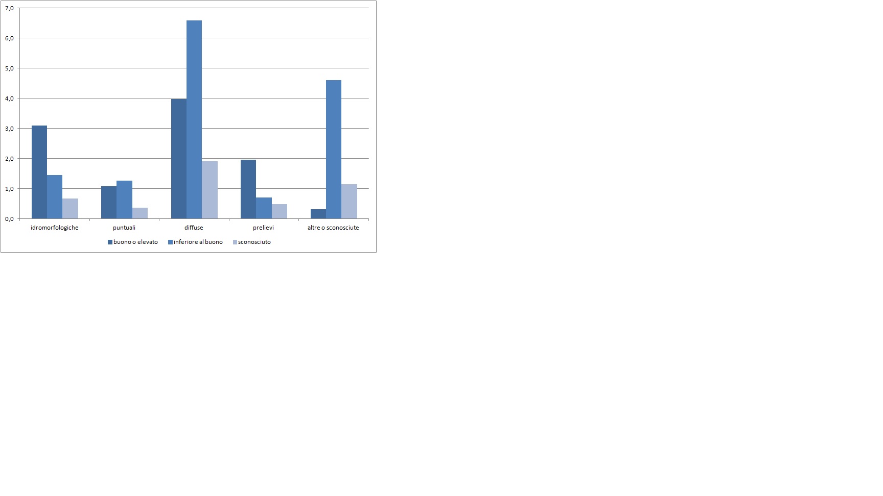
Figure 2: Ecological and/or chemical state of water bodies subject to a single type of pressure
ISPRA processing on data District Basin Authority
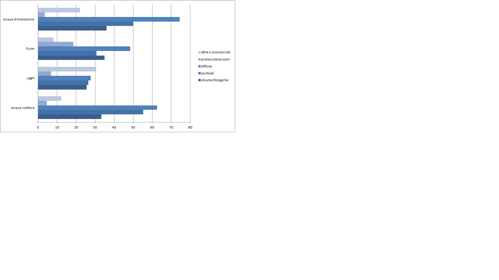
Figure 3: Water bodies subject to one or more types of pressure - distribution of the main types of pressure per body category
ISPRA processing on data District Basin Authority
Percentages are calculated relative to the number of water bodies in each category
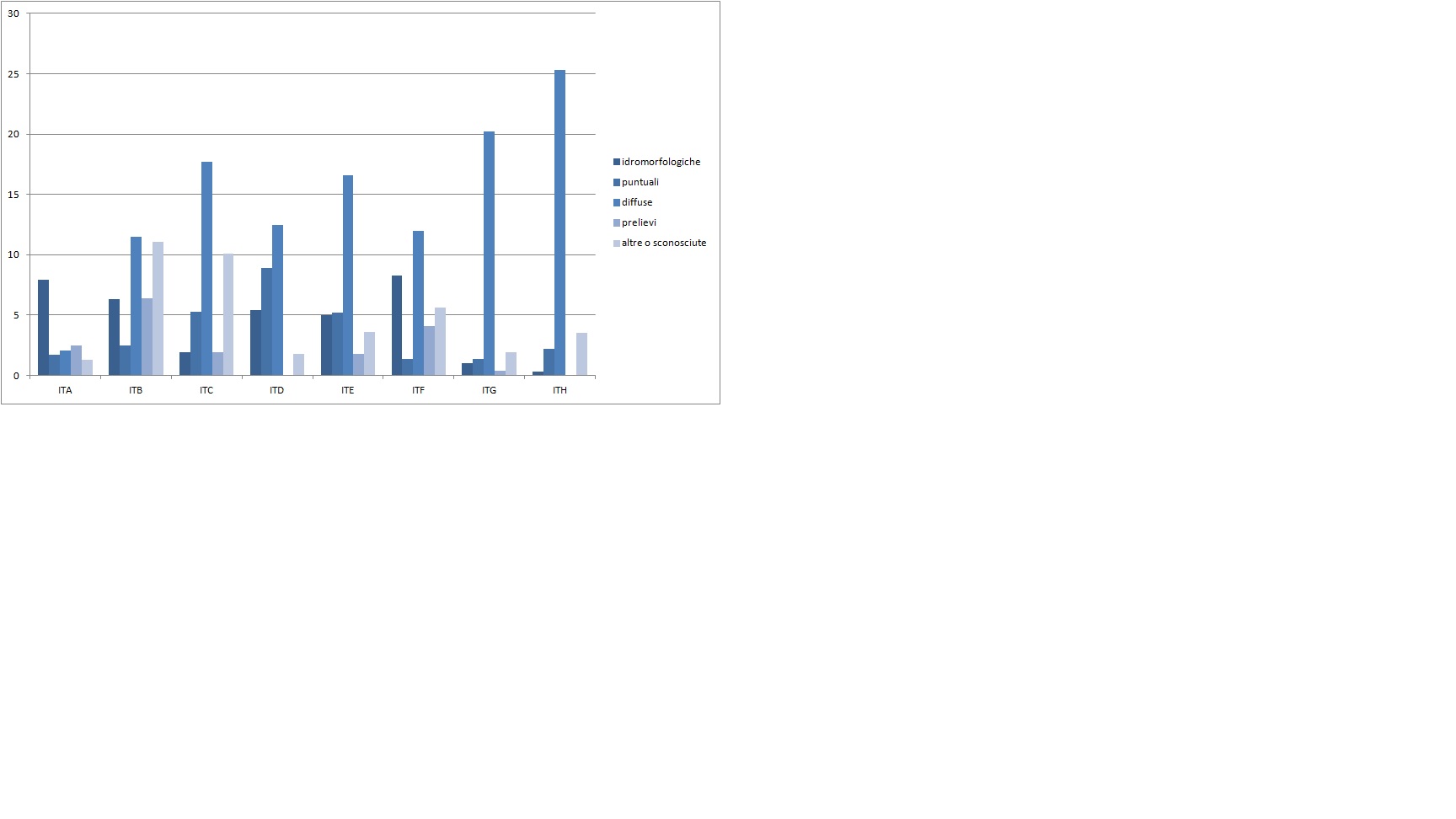
Figure 4: Distribution of the main pressure types per district: each water body is subject to a single type of pressure
ISPRA processing on data District Basin Authority
ITA Districts - Eastern Alps; ITB - Fiume Po; ITC - Northern Apennines;ITD - Serchio ; ITE - Central Apennines; ITF -
Southern Apennines; ITG-Sardinia; ITH-Syrac of Italy
Percentages are calculated relative to the number of water bodies in each category
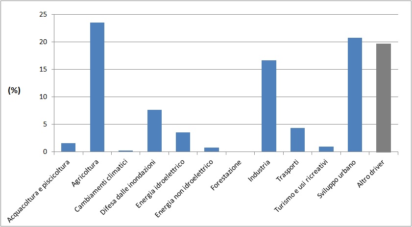
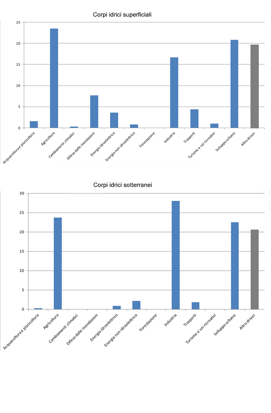
Figure 5: Surface water bodies - Incidence of socio-economic and environmental determinants by type of pressure
ISPRA processing on data District Basin Authority
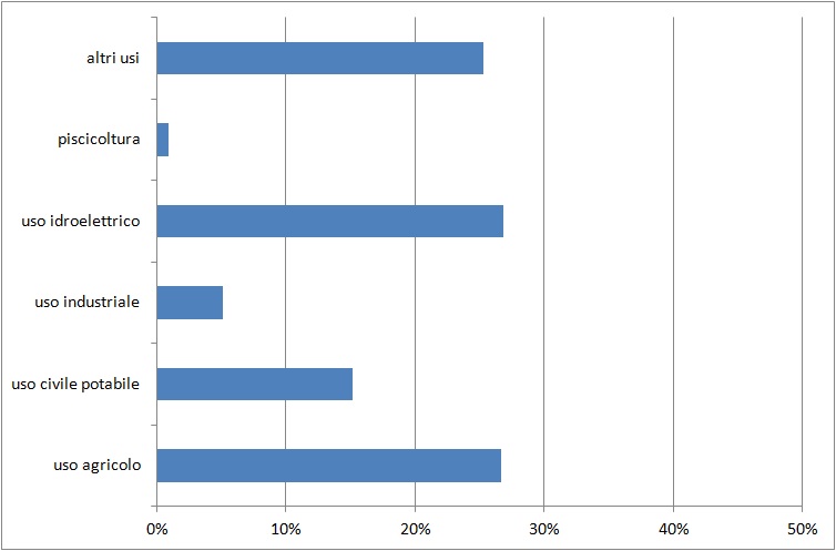
Figure 6: Drawings and diversions, distribution between different uses for surface water bodies
ISPRA processing on data District Basin Authority
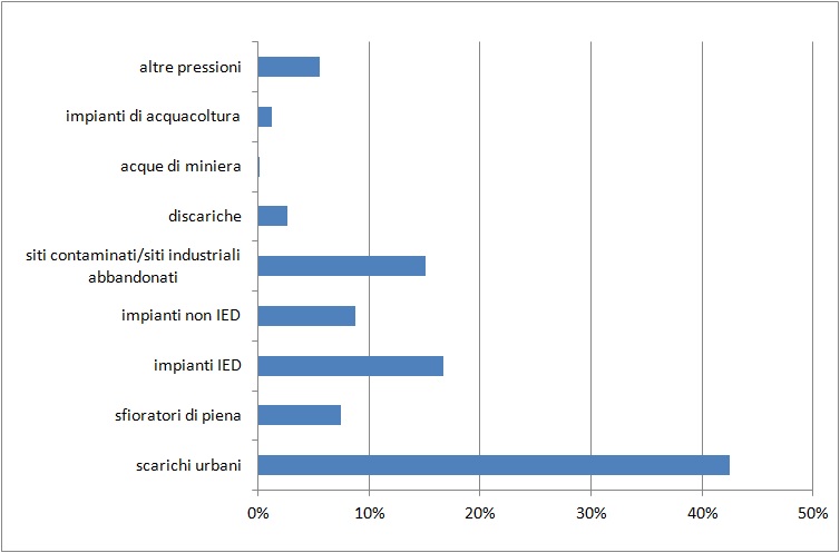
Figure 7: Punctual pressures, distribution between different uses for surface water bodies
ISPRA processing on data District Basin Authority
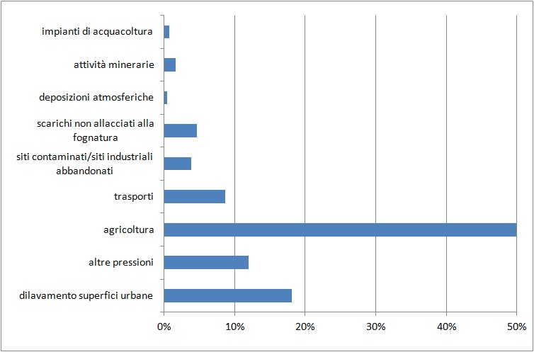
Figure 8: Diffuse pressures, distribution between different uses for surface water bodies
ISPRA processing on data District Basin Authority
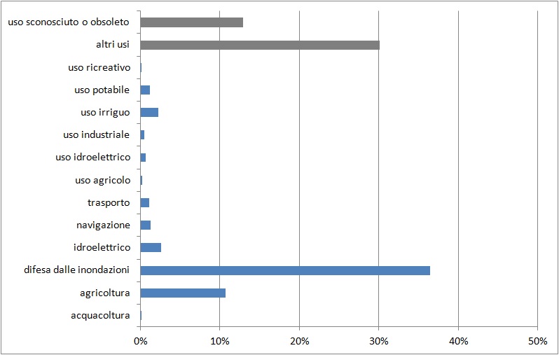
Figure 9: Hydromorphological pressures, distribution between different types of alterations for surface water bodies
ISPRA processing on data District Basin Authority
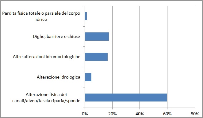
Figure 10: Hydromorphological pressures, distribution between different uses for surface water bodies
ISPRA processing on data District Basin Authority
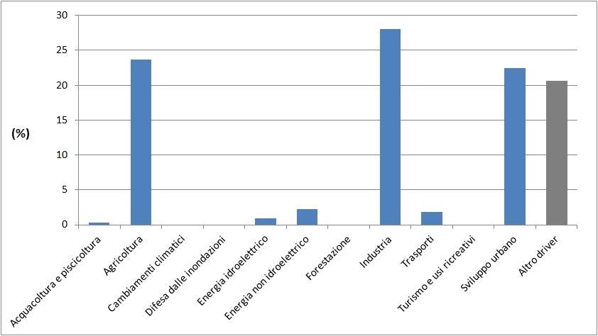
Figure 11: Underground water bodies - Incidence of socio-economic and environmental determinants by type of pressure
ISPRA processing on data District Basin Authority
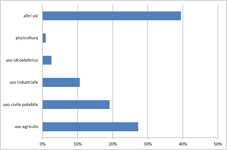
Figure 12: Withdrawals and diversions, distribution between different uses for underground water bodies
ISPRA processing on data District Basin Authority
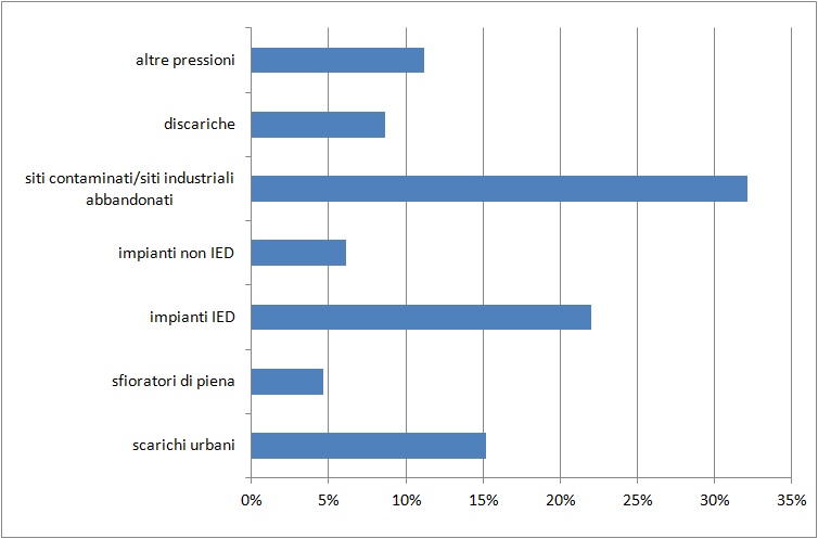
Figure 13: Punctual pressures, distribution between different uses for groundwater bodies
ISPRA processing on data District Basin Authority
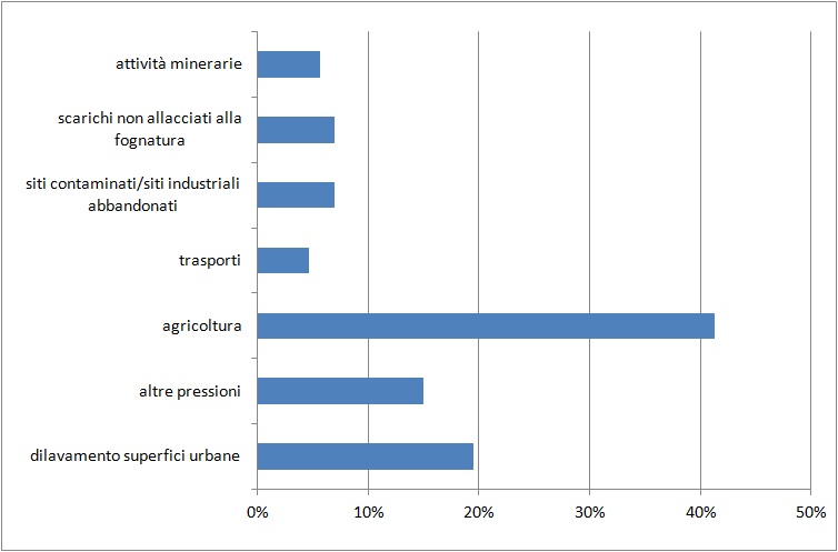
Figure 14: Diffuse pressures, distribution between different uses for underground water bodies
ISPRA processing on data District Basin Authority
abstract
The calculations for the indicator were carried out using various data aggregations to represent different aspects of the same indicator. Comparing surface water bodies subject to a single type of pressure and those subject to multiple pressures (Figure 1), it emerges that multiple concurrent pressures are predominant for all pressure types. The ecological and/or chemical quality status of surface water bodies subjected to major pressure types is mainly below “good” for diffuse pressures, while for hydromorphological pressures and withdrawals, a higher number of water bodies are in "good" or "high" status (Figure 2).
Representing the distribution of major pressure types across four water body categories (Figure 3) shows that diffuse pressures are consistently prevalent compared to others, particularly in transitional and coastal waters. Lakes are, on average, the least pressured water category. Figure 4, showing the distribution of major pressure types by District Basin Authority, highlights that diffuse pressures are the predominant type in all districts except for the Eastern Alps District, where hydromorphological pressures affect a higher number of water bodies.
As shown in Figure 5, for surface water bodies, agriculture and urban development are the main determinants, while for groundwater, industry has the highest incidence, followed by agriculture and urban development, which also have high percentages (Figure 11). Other figures represent, for each pressure type and for both surface and groundwater, the distribution among different uses. It is clear that for diffuse pressures, agriculture is the predominant use for both water bodies (Figures 8 and 14), while for withdrawals/diversions the hydropower, agriculture, and other uses are comparable for surface waters (Figure 6). For groundwater, other uses predominate, followed by agriculture (Figure 12).
For hydromorphological pressures, which only affect surface water bodies, flood defense is the predominant use (Figure 9). Regarding this pressure type, as shown in Figure 10, the highest percentage is recorded for physical alterations of channels, riverbeds, riparian beltand banks.