ARTIFICIAL RESERVOIRS
Data aggiornamento scheda:
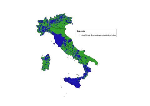
The number of reservoirs classified as Large Dams, pursuant to Law No. 584 of 21 October 1994 and the subsequent Ministry of Public Works Circular No. 482/1995, amounts to 522 (December 2024). Based on the surveys provided by the Regions and/or retrieved online up to September 2025, the total number of water bodies (artificial reservoirs, tanks, natural lakes, ponds, wetlands, etc.) is 41,918.
For Large Dams, information is complete at the national level. For small reservoirs under regional jurisdiction, census data or estimates are available for all Regions; however, in some cases these data are partial and incomplete, and it is estimated that at least 35% of them are equipped with dam structures.
EVENTI SISMICI
Data aggiornamento scheda:
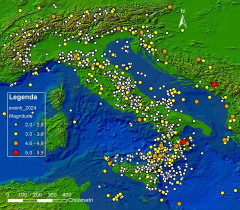
The indicator describes seismic events that occurred in Italy during the reference year, based on Magnitude values recorded by the National Seismic Network of INGV. In 2024, no destructive earthquakes occurred in Italy. Only one event reached Magnitude 5 in the province of Cosenza, which nonetheless caused no significant surface effects. Additionally, 13 events with Magnitudes between 4 and 4.6 were recorded within Italian territory and across borders up to 100 km away. The number of earthquakes with Magnitude ≥ 2 in 2024 (2,031) is comparable to the number recorded in the previous five years, with a slight decrease in 2021. As usual, most events were concentrated along the Apennine arc, the Eastern Alps, and Eastern Sicily.
CULTURAL HERITAGE EXPOSED TO SEISMIC HAZARD
Data aggiornamento scheda:
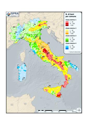
As of December 31, 2024, 16,729 cultural heritage sites are located in municipalities classified as areas with a high probability of strong earthquakes, representing 7.3% of the total cultural heritage.
EXPOSURE TO SEISMIC AND GEOLOGICAL-HYDRAULIC HAZARDS OF ARTIFICIAL RESERVOIRS
Data aggiornamento scheda:
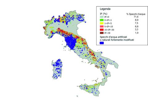
The indicator analyzes the distribution of large and small dams in relation to the seismic classification of the national territory (Map of seismic zones OPCM March 20, 2003, n. 3274 and subsequent integrations), the Landslide Index of the IFFI Project (Italian Landslide Inventory), and the distribution of landslide-prone areas. For the year 2024, the indicator shows that the water surface of artificial and heavily modified natural lakes (the water perimeter for large and small dams) in areas with a null Landslide Index (IF) constitutes 71.6%, while only 1.8% falls in areas with a higher IF (IF>30). In terms of seismic activity, 7.4% of large dams and 2.2% of small dams are are located in the most dangerous area (seismic zone 1), while 20.6% and 11.9%, respectively, are in the least dangerous area (seismic zone 4). Due to incomplete data on the distribution of small reservoirs at the national level, the result is considered partial.
SEISMIC CLASSIFICATION AND SEISMIC MICROZONATION
Data aggiornamento scheda:
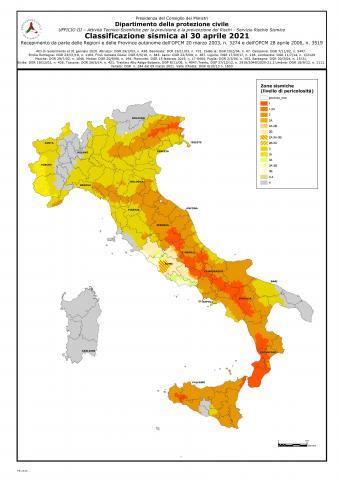
This indicator focuses on the evolution of seismic classification and seismic regulations in Italy, with particular reference to seismic microzonation (MS). Regarding seismic classification, although it has not been the regulatory reference for seismic design since 2006—where reference is now made directly to the Technical Standards for Construction (Ministerial Decree of January 17, 2018)—it continues to serve as a reference for technical and administrative controls. The latest update provided by the Civil Protection Department, as of April 2021, classifies the territory into four main classes and sixteen subclasses, based on proposals from each region for its municipalities.
Regarding regulations governing seismic microzonation studies, the Civil Protection Department, in collaboration with the Conference of Regions and Autonomous Provinces, defined general guidelines and criteria in 2008. In subsequent years, some regions issued specific technical regulations adapting the general guidelines to their territories based on their particular vulnerabilities, concerning seismic amplification issues and, in some cases, surface fault rupture hazards. The seismic sequence that affected Central Italy starting on August 24, 2016, spurred the implementation of Level III seismic microzonation studies in all 140 affected municipalities. These studies were validated by a working group established by the Special Commissioner for Reconstruction in Central Italy. Various in-depth studies on active and capable faults within the Level III microzonation framework are ongoing and are expected to be completed by the end of 2021.
ENVIRONMENTAL EFFECTS OF EARTHQUAKES
Data aggiornamento scheda:
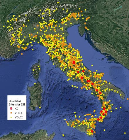
The indicator describes the environmental effects induced by earthquakes and represents the susceptibility of the Italian territory to such effects. Susceptibility depends on the varying degrees of seismicity present in different portions of the Italian territory and the local geomorphological and geological characteristics. It also provides a map of the ESI (Environmental Seismic Intensity) values reached during known seismic history in Italy, representative of the effects that may occur again in the future due to similar earthquakes.
In 2022, only one earthquake was recorded in which seismic-induced environmental effects were reported. This was the earthquake that occurred on December 4, 2022, in the Aeolian Islands, with a magnitude of 4.5, which induced modest collapse phenomena in some sites on Lipari and Vulcano.
SURFACE FAULTING INDEX IN URBAN AREAS
Data aggiornamento scheda:
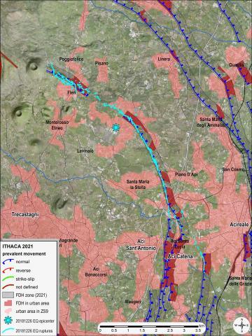
The indicator provides an estimate of the level of exposure of urban areas to surface faulting hazards. For each seismogenic zone in the ZS9 zoning, the indicator measures the areal extension of urbanized areas exposed to surface faulting hazards due to their proximity to capable faults (ITHACA Catalog). These faults are delineated considering the predominant kinematics of the fault, with an extension that depends on the maximum expected displacements.
The most critical situations are confirmed in eastern Sicily, particularly in the Etna area. A comparison with the last assessment (in 2014) shows an increase attributable to the greater expansion of urban areas near capable faults, as well as to the higher number of capable faults included in ITHACA, due to the progressive improvement in knowledge about the recent tectonic activity of certain structures.
SURFACE FAULTING (CAPABLE FAULTS)
Data aggiornamento scheda:
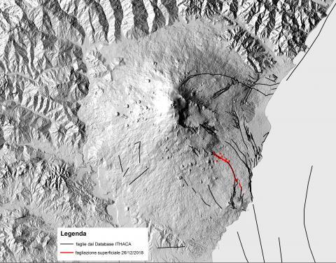
The indicator provides information on surface faulting events associated with the reactivation of capable faults in Italy. These faults typically become active during strong earthquakes, but also in response to earthquakes with relatively low magnitudes if they are shallow, as occurs in volcanic-tectonic contexts, such as in the Etna region. Specifically, following the Fleri earthquake of December 26, 2018 (Mw 4.9, H = 1 km; INGV), the Fiandaca - Acicatena - Aciplatani fault system was reactivated, as it had been in the recent past.
Surface faulting along the Fiandaca fault was documented over a length of approximately 5 km. The rupture along the Aciplatani fault, however, was not co-seismic, but appeared several hours after the seismic event, with cracks opening a few centimeters that, after a few days, reached a total length of about 700 meters. These aseismic movements, known as creep, are common in some sectors of the Etna apparatus.
The damage related to the seismic event was primarily localized along the surface faulting zones, which had been affected by the same phenomenon multiple times in the past, including very recently. This highlights the importance of identifying areas with capable faults and considering them in land-use planning.
The faults reactivated in 2018 were already included in the ITHACA database, the inventory of capable faults in Italy developed by ISPRA, which provides the current state of knowledge about the distribution of faults in the national territory that are potentially capable of causing surface faulting.