Anna Maria Blumetti, Luca Guerrieri
The indicator provides information on surface faulting events associated with the reactivation of capable faults in Italy. These faults typically become active during strong earthquakes, but also in response to earthquakes with relatively low magnitudes if they are shallow, as occurs in volcanic-tectonic contexts, such as in the Etna region. Specifically, following the Fleri earthquake of December 26, 2018 (Mw 4.9, H = 1 km; INGV), the Fiandaca - Acicatena - Aciplatani fault system was reactivated, as it had been in the recent past.
Surface faulting along the Fiandaca fault was documented over a length of approximately 5 km. The rupture along the Aciplatani fault, however, was not co-seismic, but appeared several hours after the seismic event, with cracks opening a few centimeters that, after a few days, reached a total length of about 700 meters. These aseismic movements, known as creep, are common in some sectors of the Etna apparatus.
The damage related to the seismic event was primarily localized along the surface faulting zones, which had been affected by the same phenomenon multiple times in the past, including very recently. This highlights the importance of identifying areas with capable faults and considering them in land-use planning.
The faults reactivated in 2018 were already included in the ITHACA database, the inventory of capable faults in Italy developed by ISPRA, which provides the current state of knowledge about the distribution of faults in the national territory that are potentially capable of causing surface faulting.
The indicator provides the state of knowledge regarding the distribution of capable faults across the national territory. These faults are fractures in the Earth's crust that may potentially reactivate in the near future (in association with seismic events) or move slowly and continuously (aseismic creep), displacing or deforming the land surface (surface faulting).
Information about these faults, including their orientation, geometry, kinematics, associated earthquakes, and average deformation rate, is collected in a catalog (ITHACA - ITaly HAzard from CApable faults) developed and managed by ISPRA. The catalog consists of a periodically updated database and detailed maps managed in a GIS environment.
Displacements along capable faults can cause significant damage to man-made structures that intersect these faults. The indicator also provides detailed information about surface faulting or soil deformation events that may have occurred in the analyzed period along capable faults.
Information about the location and characteristics of capable faults is crucial for land-use planning, which should appropriately consider their presence. Man-made structures (infrastructures, buildings) should ideally be placed at a safe distance from capable faults or be designed with appropriate technical measures to accommodate tectonic deformation.
Guidelines and general criteria for seismic microzonation studies from the Technical Commission for Seismic Microzonation, Department of Civil Protection (2009).
Guidelines for land management in areas affected by Active and Capable Faults (FAC), version 1.0, Department of Civil Protection (2015).
The issue of surface faulting has been addressed in the Guidelines and Criteria for Seismic Microzonation, approved by the Conference of Regions and Autonomous Provinces (2008) and published by the Civil Protection Department in March 2009. These guidelines recommend the need for detailed seismotectonic and paleoseismological studies (through excavation and analysis of exploratory trenches) aimed at producing fault zone maps (main trace and setback zone), at a 1:5,000 scale.
Subsequently, the Civil Protection Department (2015) issued the "Guidelines for land management in areas affected by Active and Capable Faults (FAC)", defining these faults as those that have shown activity, with deformation reaching the topographic surface, in the last 40,000 years.
Additionally, Potentially Active and Capable Faults (FPAC) are identified, based on studies that show activity during the Middle to Upper Pleistocene. In Level 3 microzonation, these faults should be investigated with appropriate surveys to determine whether their activity continued into the last 40,000 years.
Regarding a specific FAC, in Level 1 microzonation, a homogeneous microzone must be constructed to include the presumed main fault rupture trace and the related potential surface deformation phenomena. This area is called the "Attention Zone" for FAC and must be further investigated in Level 3, where Susceptibility and Respect Zones for FAC will be established.
Bella D., Tringali G., Boso D., Livio F., Ferrario M.F., A. M. Michetti, Porfido S, Blumetti A. M., Di Manna P., Vittori E. (2019) - Surface faulting and environmental effects accompanying the Dec. 26, 2018, Mw 4.9 Fleri earthquake, Mt. Etna volcano Italy. Abstract Volume, XX INQUA Congress, Dublin, 25-31 July 2019.
https://app.oxfordabstracts.com/events/574/submissions/89724/abstract-book-view
Difficulty in representing the data uniformly at a national scale, due to the absence of studies with the same level of detail and quality.
Research update.
ISPRA (Superior Institute for Environmental Protection and Research)
ITHACA-ITaly HAzard catalog from CApable ISPRA
National
2000-2018
Bibliographic analysis and site studies
In 2018, following the Fleri earthquake of December 26 (Mw 4.9, H = 1 km; INGV), the Fiandaca - Acicatena - Aciplatani fault system was reactivated, leading to noticeable surface faulting events.
In particular, along the Fiandaca fault, N-S, NNW-SSE, and NW-SE oriented ruptures were mapped, almost continuously, over a length of about 5 km, characterized by openings from 20 cm to approximately 1.5 meters, with both vertical and horizontal displacements, with a right-lateral component of 10-30 cm and 2-15 cm respectively.
The rupture along the Aciplatani fault, however, was not co-seismic, but appeared several hours after the seismic event, characterized by fractures opening a few centimeters. These, a few days after the event, reached a length of about 700 meters. These movements, which are not associated with earthquakes, are referred to as creep and are common in some sectors of the Etna apparatus. Along the Aciplatani fault, surface ruptures due to creep are a recurring phenomenon, and have been reported in the past (1879, 1886, and 1899).
The damage related to the seismic event was mainly localized along the surface faulting zones, which had been affected by the same phenomenon several times in the past (the Fiandaca fault generated surface faulting during the seismic events of 07/01/1875, 08/08/1894, 07/12/1907, 07/05/1914, 03/08/1931, 19/06/1984, 19/10/1984, 25/10/1984, 11/11/1997), demonstrating the importance of identifying areas with capable faults and considering them in territorial planning.
The surface faulting event observed during the 2018 earthquake in the Etna region involved already known active and capable faults included in ITHACA, the catalog of capable faults affecting the Italian territory.
In general, the current state of knowledge regarding capable faults is decent, but further research is necessary to achieve the level of detail required for a satisfactory assessment of surface faulting hazard and the consequent territorial planning that can adequately account for it. The database is periodically updated. The indicator is linked to a natural phenomenon of endogenous origin over which humans have no control. Therefore, attention must focus on the vulnerability of the territory and materialize in responsible planning choices.
| Data |
|---|
Thumbnail
Headline
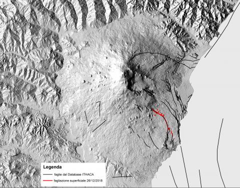
Figura 1: Mappa della fagliazione superficiale indotta dal terremoto di Fleri del 26 Dicembre 2018 Data source
ISPRA |
Thumbnail
Headline
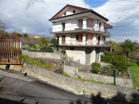
Figura 2: Effetto della fagliazione superficiale del terremoto di Fleri in località Santa Maria La Stella. Data source
ISPRA |
Thumbnail
Headline
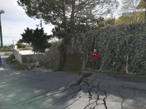
Figura 3: Fagliazione superficiale del terremoto di Fleri che disloca il manto stradale in località Santa Maria La Stella. Data source
ISPRA |
Thumbnail
Headline
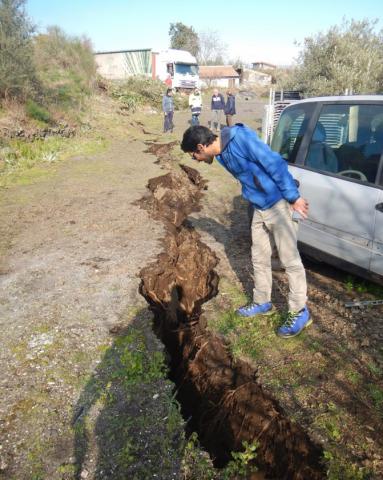
Figura 4: Profonda frattura nel terreno interpretata come effetto di fagliazione superficiale associata al terremoto di Fleri Data source
ISPRA |
Thumbnail
Headline
Figura 5: Altre rotture superficiali nel terreno che dislocano anche il manto stradale, interpretate come effetto di fagliazione superficiale Data source
ISPRA |
Figure 1 shows the surface faulting pattern of the Fleri earthquake of December 26, in the context of the active and capable faults known in the literature and present in the ITHACA database (ITaly HAzard from CApable faults) for the Etna area.
Figure 2 shows a house in the Santa Maria la Stella area, made uninhabitable due to the co-seismic surface faulting of the December 26, 2018 earthquake. This house is built along the Fiandaca fault. Note how the main rupture is located approximately at the middle of a slope (a so-called "fault scarp"), which is the morphological expression of the capable fault, carefully cataloged and mapped in the ITHACA database by ISPRA. Following the event, the house, in addition to being crossed by the fractures visible in the photo, tilted a few degrees, which cannot be recovered by any construction intervention.
Figure 3 shows the fractures on the other side of the street compared to Figure 2. This image also illustrates how the fractures are located along a scarp, which is a fault scarp.
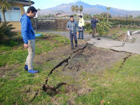
Figures 4 and 5 document other sites affected by surface faulting associated with the Fleri earthquake of December 26, 2018.