Anna Maria Blumetti, Valerio Comerci, Sergio Castenetto (Dipartimento della Protezione Civile)
This indicator focuses on the evolution of seismic classification and seismic regulations in Italy, with particular reference to seismic microzonation (MS). Regarding seismic classification, although it has not been the regulatory reference for seismic design since 2006—where reference is now made directly to the Technical Standards for Construction (Ministerial Decree of January 17, 2018)—it continues to serve as a reference for technical and administrative controls. The latest update provided by the Civil Protection Department, as of April 2021, classifies the territory into four main classes and sixteen subclasses, based on proposals from each region for its municipalities.
Regarding regulations governing seismic microzonation studies, the Civil Protection Department, in collaboration with the Conference of Regions and Autonomous Provinces, defined general guidelines and criteria in 2008. In subsequent years, some regions issued specific technical regulations adapting the general guidelines to their territories based on their particular vulnerabilities, concerning seismic amplification issues and, in some cases, surface fault rupture hazards. The seismic sequence that affected Central Italy starting on August 24, 2016, spurred the implementation of Level III seismic microzonation studies in all 140 affected municipalities. These studies were validated by a working group established by the Special Commissioner for Reconstruction in Central Italy. Various in-depth studies on active and capable faults within the Level III microzonation framework are ongoing and are expected to be completed by the end of 2021.
The indicator tracks the evolution of seismic classification and seismic regulations in Italy, with a particular focus on seismic microzonation.
Seismic classification was periodically revised and refined between 1984 and 2006, incorporating advances in scientific knowledge. Since 2006, while it remains a reference for technical and administrative controls, it is no longer the regulatory reference for seismic design, which now refers directly to the Technical Standards for Construction (NTC), approved by the Ministerial Decree of January 17, 2018.
The specific regulations concerning seismic microzonation (MS) are more recent. In 2008, the Conference of Regions and Autonomous Provinces and the Civil Protection Department published the "Guidelines and Criteria for Seismic Microzonation" (ICMS 2008), which outline the principles and fundamental elements for conducting MS studies and their application to territorial planning and emergency phases. These guidelines were later updated and supplemented with representation and digital archiving standards for MS studies, as well as specific guidelines for managing areas affected by co-seismic phenomena.
The adoption of national guidelines and standards has taken place through specific regional regulations. In some cases, this was a response to major earthquakes (such as in Abruzzo following the 2009 L'Aquila earthquake and in Emilia-Romagna after the 2012 seismic sequence). However, even regions not recently affected by significant seismic events, such as Friuli Venezia Giulia, Lazio, and Veneto, have adopted these standards.
To provide an updated overview of the evolution of seismic classification in Italy, as defined by each region for the municipalities within its jurisdiction, as well as the national and regional regulations related to seismic microzonation.
With Ordinance of the Prime Minister (OPCM) No. 3274 of March 20, 2003, the criteria for the current seismic classification were defined. For the first time, the entire national territory was considered subject to seismic hazard, albeit with significant variations among different areas of the Peninsula. In this classification, Italy is divided into four zones: the first three zones have high, medium, and low seismicity, while Zone 4 allows regions to decide whether or not to impose seismic design requirements.
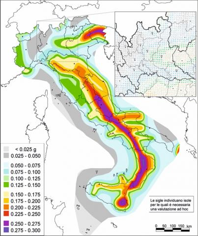
With OPCM No. 3519 of April 28, 2006, an update to the national criteria for seismic reclassification was issued, establishing that each region must update its own seismic classification. The same Ordinance states that the new classification must be based on the actual baseline seismic hazard of the territory, independent of administrative boundaries, and provides the criteria for determining such hazard along with a new national seismic hazard map. According to these criteria, Italy is divided into four zones characterized by different classes of maximum ground acceleration (ag), expressed as a fraction of gravity acceleration (g), with a 10% probability of occurrence over 50 years. The Technical Standards for Construction (NTC), first approved by the Ministerial Decree of January 14, 2008, and updated with the Ministerial Decree of January 17, 2018 (NTC2018), apply to these seismic zones. These standards serve as the regulatory reference for seismic design and directly refer to the "baseline seismic hazard," which is the aforementioned seismic hazard map provided by the National Institute of Geophysics and Volcanology (INGV).
The Guidelines and Criteria for Seismic Microzonation (ICMS 2008) set as the objective of Seismic Microzonation (MS) the rationalization of knowledge regarding alterations that seismic shaking can undergo at the surface compared to that expected on reference soil. These guidelines provide useful information for land management, design, planning, emergency response, and post-earthquake reconstruction.
Through MS studies, it is possible to identify and characterize stable zones, stable zones susceptible to local amplification, and zones subject to instability (permanent ground deformation) under seismic conditions, such as landslides, surface fault ruptures, soil liquefaction, and differential settlements. Each phenomenon is parameterized according to the guidelines for instabilities, approved by the Interinstitutional Technical Commission for MS (Article 5, OPCM 3907/10).
The technical reference document for conducting MS studies is the Guidelines and Criteria for Seismic Microzonation, approved on November 13, 2008, by the Conference of Regions and Autonomous Provinces and later updated with additional guidelines, such as the guidelines for seismically induced instabilities, which can be downloaded from the official Civil Protection Department website (www.protezionecivile.gov.it).
The national MS study plan has been largely funded through Article 11 of Law 77/2009, via the Civil Protection Department Ordinances listed below. Each Ordinance allocated and regulated the use of financial resources transferred to the regions for the implementation of study programs. Among these, Ordinance 3907 of 2010, in Article 5, states:
"To support and monitor, at the national level, the studies referred to in this article (i.e., at least Level 1 seismic microzonation studies), in accordance with the 'Guidelines and Criteria for Seismic Microzonation,' an interinstitutional Technical Commission is established, operating on a voluntary basis at the Civil Protection Department under the Presidency of the Council of Ministers."
This commission, composed of representatives from Regions, Professional Orders, and State Administrations, also oversees the development of the "Standards for Representation and Digital Archiving" of seismic microzonation studies. The latest version of these standards is 4.2, released in December 2020.
ICMS (2008) - Indirizzi e criteri generali per gli studi di Microzonazione Sismica”, Commissione tecnica per la microzonazione sismica, approvati dalla Conferenza delle Regioni e Province Autonome, Dipartimento della Protezione Civile, Roma, 2008.
DPC (2015) - Linee guida per la gestione del territorio in aree interessate da Faglie Attive e Capaci (FAC), versione 1.0. Commissione tecnica per la microzonazione sismica, approvati dalla Conferenza delle Regioni e delle Province Autonome – Dipartimento della protezione civile, Roma, 2015.
-
-
INGV (National Institute of Geophysics and Volcanology)
Civil Defense
Regions
The data used are owned by the Department of Civil Protection (DPC). Specifically, the data contained in Table 1 and processed in Figure 3 are accessible on the MS Study Information and Mapping Portal (http://webms.it) and interoperable through the WMS and WFS services.
National, Regional (20/20)
1984-2021
The data processing is carried out using information provided by the Civil Protection Department (regarding seismic classification and the guidelines on seismic microzonation) and by the regions (for the implementation of OPCM 3274/2003 and 3519/2006 and the issuance of resolutions on regional technical regulations concerning MS). These data are collected and synthesized into the indicator.
OPCM 3519/2006 reassigned to each region the responsibility of updating its own seismic classification and provided the new "General criteria for the identification of seismic zones and for the formation and updating of lists of the same zones." An important step was taken in 2008 with the approval of the new Technical Standards for Construction, enacted by the Decree of the Minister of Infrastructure and Transport on January 14, 2008. These standards are now the new regulatory reference for seismic-resistant design, while the seismic classification of the national territory continues to serve as a reference for technical and administrative controls. The regulations guiding seismic microzonation studies at the national level (ICMS 2008) have, in recent years, been adopted through regional technical regulations, also containing specific guidelines for MS studies, considering the local characteristics of each territory.
These guidelines provide procedures to collect all useful information to delineate areas susceptible to local seismic amplification or instability under seismic conditions, also characterizing them based on specific territorial vulnerabilities. Among these, mention should be made of the guidelines for land management in areas affected by active and capable faults (FAC), approved by the Civil Protection Department and the Conference of Regions in 2015. These not only describe the phenomenon of surface faulting but also define specific investigation obligations in the so-called Active and Capable Fault Attention Zones (ZAFAC), leading to the definition of Susceptibility Zones (ZSFAC) and Respect Zones (ZRFAC).
Following the seismic sequence that struck Central Italy starting on August 24, 2016, a Presidential Decree was issued on September 9, 2016, appointing a Special Government Commissioner for the reconstruction in the territories of the municipalities affected by the seismic event.
With Decree-Law No. 189 of October 17, 2016, titled "Urgent measures in favor of populations affected by the earthquake of August 24, 2016," converted into Law No. 229 of December 15, 2016, and subsequent amendments (Decree-Law No. 8 of February 9, 2017, converted into Law No. 45 of April 7, 2017), it was established that the Special Commissioner should promote the implementation of a plan aimed at equipping the affected municipalities, identified under Article 1, with Level III Seismic Microzonation, regulating through a specific ordinance the granting of contributions to the concerned municipalities.
This was achieved through Ordinance No. 24 of May 12, 2017, titled "Allocation of funding for level III Seismic Microzonation studies to Municipalities affected by seismic events," amended by Ordinance No. 55 of April 24, 2018. All 140 MS studies have been completed and validated by the working group established for this purpose by the Special Commissioner.
With Ordinance No. 83 of August 2, 2019, the Special Commissioner ordered further in-depth studies within the territories of the municipalities affected by the seismic sequence in Central Italy following the discovery of Active and Capable Faults (FAC), which are correlated with attention zones in the Seismic Perspective Homogeneous Microzones (MOPS) maps.
Thus, on October 3, 2020, a scientific collaboration agreement was signed between the Special Government Commissioner and INGV for the "redefinition of the Active and Capable Fault Attention Zones identified through seismic microzonation studies conducted in municipalities affected by seismic events since August 24, 2016."
INGV subsequently signed, in December 2020, additional collaboration agreements with CNR-IGAG, the University of L'Aquila, the University of Chieti-Pescara, the University of Camerino, ISPRA, and the University of Insubria for FAC studies to be conducted in Norcia (PG), Capitignano and Montereale (AQ), Barete and Pizzoli (AQ), Ussita (Frontignano) (MC), Cittaducale (RI), and Rieti, Cantalice, and Rivodutri (RI). In Leonessa (RI), the studies were conducted directly by INGV, which also carried out geophysical investigations in many of the aforementioned sites.
By July 2021, preliminary results had already been delivered, which, in some cases, allowed for the definition of Respect and Susceptibility Zones, useful for planning reconstruction and, in many cases, eliminating Attention Zones. For all municipalities, however, a further study phase is necessary to transition from Attention Zones to definitive Respect and Susceptibility Zones throughout the investigated territory.
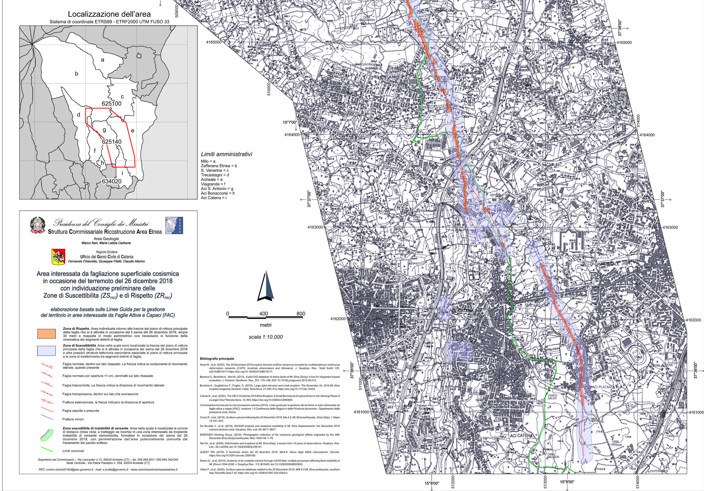
A similar activity was carried out by the Special Commissioner for the reconstruction of the Etna area. To ensure safety and speed in repair and reconstruction efforts in the areas affected by the December 26, 2018 earthquake in the province of Catania, the map titled "Area Affected by Surface Cosismic Faulting during the December 26, 2018 Earthquake with Preliminary Identification of Susceptibility and Respect Zones" was produced.
This map identifies the location of the faults that were activated on December 26, 2018, and delineates both the Susceptibility Zone (ZSFAC) and the Respect Zone (ZRFAC) around them. The identification of these areas has facilitated the reconstruction efforts, tailoring interventions based on the geological-structural characteristics of the area.
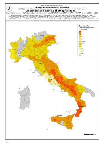
The municipal seismic classification map has been updated as of April 2021 (Figure 1).
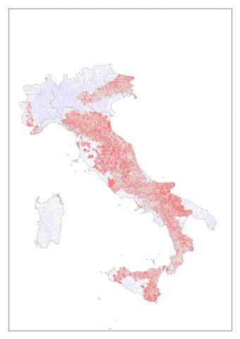
Seismic Microzonation studies continue across the country. The number of municipalities with Level I Seismic Microzonation is steadily increasing, as evidenced by the comparison of the map of municipalities funded by various ordinances for MS studies updated to June 30, 2021, compared to previous years.
| Allegati |
|---|
Titolo
Tabella 1: Numero di Comuni, per ciascuna Regione, destinatari di risorse per studi di MS e suddivisi in finanziabili, finanziati e con studi consegnati (dati aggiornati al 30 giugno 2021). Fonte
Dipartimento di Protezione Civile Legenda
*Per queste Regioni il numero di comuni finanziati comprende studi di livello 1 e livello 3. Per questo motivo il numero complessivo, in alcuni casi, supera quello dei comuni finanziabili, essendo stati realizzati, nello stesso comune, sia studi di livello 1 che 3. |
Thumbnail
Titolo
Figura 1: Mappa della classificazione sismica a livello comunale (aprile 2021) Fonte
Dipartimento di Protezione Civile (2021) |
Thumbnail
Titolo
Figura 2: Mappa di pericolosità sismica di riferimento per il territorio italiano (ai sensi dell'OPCM n. 3519 del 28 Aprile 2006) espressa in termini di accelerazione al suolo con probabilità di eccedenza del 10% in 50 anni. Fonte
INGV |
Thumbnail
Titolo
Figura 3: Mappa dei comuni finanziati dalle diverse Ordinanze per studi di MS (dati aggiornati al 30 giugno 2021). Questa mappa non rappresenta il totale dei comuni in possesso di una MS di primo livello, ma solo quelli finanziati dalle ordinanze citate. Fonte
Dipartimento di Protezione Civile |
Thumbnail
Titolo
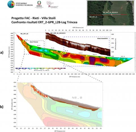
Figura 4: Indagini geofisiche e paleosismologiche effettuate in Località Villa Stoli, nel comune di Rieti, per lo studio della zona di attenzione relativa alla FAC (Faglia Attiva e Capace) riportata nella MS di I livello, lungo il bordo sudorientale del bacino di Rieti. Fonte
ISPRA, INGV Legenda
A) Confronto tra i due profili ottenuti dalle prospezioni Geoelettrica (ERT - Electrical Resistivity Tomography) e Georadar (GPR - Ground Penetrating Radar). B) sovrapposizione del log stratigrafico semplificato della trincea paleosismologica in località Villa Stoli con una porzione del profilo ERT. |
Thumbnail
Titolo
Figura 5: Esempio di indagini sulle FAC (Faglia Attiva e Capace) in area Etnea. Stralcio della Mappa dell’ “Area interessata da fagliazione superficiale cosismica in occasione del terremoto del 26 dicembre 2018 con individuazione preliminare delle Zone di Suscettibilita e di Rispetto”. Fonte
Commissario Straordinario per la ricostruzione dell’area etnea |
The seismic classification map of the national territory at the municipal level, updated in April 2021 (the latest update provided by the Civil Protection Department) following the adoption by the regions of OPCM 3274/2003 and 3519/2006, classifies each municipality into four main zones with decreasing seismic hazard (Zone 1 = most hazardous; Zone 4 = least hazardous), further divided into subzones for a total of 16 classes (Figure 1). The reference tool for these classifications is provided by the seismic hazard map, aimed at identifying seismic zones and compiling and updating the respective lists (approved by OPCM 3519/2006 and developed by the National Institute of Geophysics and Volcanology). In this map, maximum ag values are provided for reference grid points with nodes no more than 10 km apart (0.05° grid) and for a 10% probability of exceedance within the next 50 years.
Regarding seismic microzonation studies, Figure 3 shows the map of municipalities funded through various Ordinances (OPCM and OCDPC) that allocate funds in implementation of Article 11 of Decree-Law No. 39 of April 28, 2009, converted with amendments into Law No. 77 of June 24, 2009. This map does not represent the total number of municipalities possessing a first-level microzonation study but only those funded by the cited ordinances.
Since December 2020, third-level in-depth studies have been underway on active and capable faults in various municipalities affected by the seismic sequence that began in August 2016 in Central Italy. Figure 4 illustrates the geophysical and paleoseismological studies conducted in Villa Stoli, in the municipality of Rieti, to examine the area of concern related to the Active and Capable Fault (FAC) reported in first-level microzonation studies along the southeastern edge of the Rieti Basin.
A) Comparison between two profiles obtained through Electrical Resistivity Tomography (ERT) and Ground Penetrating Radar (GPR) surveys.
B) Overlay of the simplified stratigraphic log of the paleoseismological trench at Villa Stoli with part of the ERT profile.
Similar studies have already been conducted in the eastern slope area of Mount Etna. Figure 5 presents the results of these studies on Active and Capable Faults (FAC), represented by the map of the "Area affected by surface faulting during the December 26, 2018 earthquake with preliminary identification of Susceptibility and Respect Zones," developed by the Etna Area Reconstruction Commissarial Structure.
Finally, Table 1 provides, for each region, the number of fundable, funded, and completed microzonation studies (updated as of June 30, 2021). Specifically, fundable municipalities are those with ag>0.125 g (Figure 2), to which funds are allocated (the regions of Trentino-Alto Adige, Valle d'Aosta, and Sardinia have no municipalities meeting these conditions). Funded municipalities are those where studies have been conducted or are in progress. Delivered studies refer to those submitted to the National Technical Monitoring Commission. The progress of study implementation varies by region. In three regions (Piemonte, Marche, and Molise), all fundable studies have been completed. In some regions, nearly all studies have been conducted, while in others, a significant number of studies still need to be carried out despite the allocated funding.