Stefano Calcaterra, Piera Gambino, Daniela Niceforo
The number of reservoirs classified as Large Dams, pursuant to Law No. 584 of 21 October 1994 and the subsequent Ministry of Public Works Circular No. 482/1995, amounts to 522 (December 2024). Based on the surveys provided by the Regions and/or retrieved online up to September 2025, the total number of water bodies (artificial reservoirs, tanks, natural lakes, ponds, wetlands, etc.) is 41,918.
For Large Dams, information is complete at the national level. For small reservoirs under regional jurisdiction, census data or estimates are available for all Regions; however, in some cases these data are partial and incomplete, and it is estimated that at least 35% of them are equipped with dam structures.
The indicator provides information on the number and geographical location of Large Dams and small reservoirs; the surface area of reservoirs is available only for 85% of Large Dams.
Large Dams, as defined by Law No. 584 of 21 October 1994 and the subsequent Ministry of Public Works Circular No. 482/1995, are structures with a height greater than 15 m or that create a reservoir volume exceeding 1,000,000 m³. For values equal to or below either of these thresholds, the structures are referred to as small dams (small reservoirs) or hill reservoirs.
For Large Dams, the data provider is the Ministry of Infrastructure and Transport (MIT) – Directorate General for Dams and Water Infrastructure (DG Dighe), whereas for small dams responsibility generally lies with the individual Regions, except for the Autonomous Provinces of Trento and Bolzano.
With regard to Large Dams and related works, DG Dighe is currently responsible, among other tasks, for archiving technical and administrative data in the National Register of Large Dams.
By contrast, for small dams, in many cases the Regions have not yet established dedicated databases, partly due to the lack of regulatory adaptation through appropriate legislative instruments.
The purpose is the census and cataloguing of artificial or modified natural reservoirs equipped with dam structures, excluding underground and covered reservoirs, and the analysis of their spatial distribution across the national territory.
The current national regulatory framework (Presidential Decree 1363/59 and subsequent provisions supplementing the same Regulation: Ministry of Public Works Circulars of 28 August 1986 No. 1125 and 4 December 1987 No. 352; Law No. 584 of 21 October 1994; Prime Minister’s Circular of 13 December 1995 No. DSTN/2/22806; Ministry of Public Works Decree 24 March 1982; Law No. 183/1989; Decree Law No. 507/1994 converted into Law No. 584/1994; Law No. 139/2004; Legislative Decree No. 152/2006; Ministerial Decrees of 14 January 2008 and 26 June 2014) governs the technical standards for the design and construction of dams, defines the rules for their operation, establishes implementing provisions, and allocates responsibilities for Large and small dams.
It also identifies urgent safety measures for Large Dams following revisions in national seismic risk legislation (Law No. 64/1974; Law No. 139/2004; OPCM No. 3519 of 28 April 2006) and sets out operational guidelines for the management of hydrogeological and hydraulic critical conditions (Prime Minister’s Decree of 27 February 2004; Prime Minister’s Directive of 8 July 2014).
Underground or elevated storage tanks are not subject to dam legislation, as they lack dam structures. Also excluded are all dam works creating reservoirs used exclusively for the storage, settling, or washing of industrial residues, which, under Law No. 584/1994, fall under the authority of the former Ministry of Industry, Commerce and Crafts, now the Ministry of Enterprises and Made in Italy (MIMIT).
In the field of seismic safety, several circulars have been issued (DG Dighe Circulars of 27 September 2017 No. 21530; 8 November 2017 No. 25157; 18 March 2019 No. 6660; 3 July 2019 No. 16790), providing guidance on methodologies and contents for the assessment of seismic hazard at dam sites and updating procedures for extraordinary inspections following seismic events.
The recent Director’s Decree DG Dighe No. 510/2025 defines criteria and technical procedures for classifying retention structures based on dam typology, dimensional characteristics, operational behaviour, seismicity, and other site features, as well as downstream territory characteristics, in compliance with Article 4 of Ministerial Decree No. 94 of 14 May 2024.
For small dams, Article 1 of Law No. 584/1994 (and subsequent Legislative Decree No. 112/1998) assigns responsibility to the Regions and Autonomous Provinces of Trento and Bolzano for dams not exceeding 15 m in height or creating reservoirs not exceeding 1,000,000 m³.
Article 2, paragraph 2-bis, of Law No. 584/1994 required Regions to adopt their own regulations within six months of the issuance of the national regulation, while maintaining the application of Presidential Decree No. 1363/1959 until the new regional regulations entered into force.
Several Regions and/or Provinces have enacted legislation on small reservoirs and implementing provisions governing project approval and operational control (Basilicata, Sardinia, Veneto, Piedmont, Aosta Valley, Tuscany, Abruzzo, Campania, Molise, Umbria, Emilia-Romagna, Lombardy, the Autonomous Provinces of Trento and Bolzano, and the Civil Engineering Office of Catania).
Some regional laws define reservoir risk categories based on the guidelines issued by the Presidency of the Council of Ministers – Department of Civil Protection (31 July 1991).
EU Directive 2000/60/EC establishes the obligation to prepare river basin management plans to achieve good ecological and chemical status of waters. Legislative Decree No. 152/2006 defines:
- Artificial water body: a surface water body created by human activity.
- Heavily modified water body (HMWB): a surface water body substantially altered by physical modifications due to human activity.
HMWBs are typically created by dams or weirs for civil, industrial (e.g., hydropower), and agricultural uses.
Calizza E. & Menga R. (1998) Catalog and classification of Italian dams by satellite survey. Dam Safety, Bergamo 1998;
Caruana Rosella, Catalano Angelica, Paoliani Paolo, Ruggeri Giovanni (2010) Controls of dams in the territory affected by the Abruzzo seismic sequence of April 2009. L'Acqua-Rivista Bimestrale. Year: 2010 Edition: n. 4 pages 25;
Castelli S., Cassese E., Frosio N., Magno A., Ropele P., Sainati F., Valgoi P. And Masera A. (2010) Small Dams in Italy. Proceedings of the 8th ICOLD European Club Symposium Dam Safety - Sustainability in a Changing Environment 22nd - 23rd September 2010 Innsbruck, Austria;
ITCOLD-Italian Committee for Large Dams LARGE DAMS (2017) Small dams in Italy. WG Report, 2017;
Lai, C. G., Corigliano, M., Agosti, M. (2009) Dams and earthquakes: the case of the L'Aquila earthquake. Seismic Design. Vol. 1, No. 3, pp. 183-205; September-December 2009; ITCOLD study day. Rome 28 March 2017;
https://www. regione. abruzzo. it/content/dighe-e-invasi;
http://www2. consiglio. regione. abruzzo. it/leggi/lexreght/testilex/0338112. htm ;
https://portal. sardegnasira. it/web/sardegnaambiente/laghi-e-invasi ;
https://www. arpa. sicilia. it/temi-ambientali/acque/monitoraggio-acque-superficiali-invasi/;
http://pti. regione. sicilia. it/portal/page/portal/PIR_PORTALE/PIR_LaStrutturaRegionale/PIR_AssEnergia/PIR_Dipartimentodellacquaedeirifiuti/PIR_Areetematiche/PIR_Settoreacque/PIR_PianoGestioneDistrettoIdrograficoSicilia;
https://www. parcosila. it/it/;
For Large Dams, the indicator is populated using data published by the Ministry of Infrastructure and Transport – Directorate General for Dams and Water Infrastructure, while for small reservoirs, data provision varies as responsibility lies with Regions or Provinces/Municipalities. Consequently, while a complete national archive exists for Large Dams, data quality for other reservoirs varies significantly among Regions.
Not all Regions have accessible databases, and inventory methods differ widely (photo-interpretation, administrative regularization, field surveys). As a result, datasets are not yet homogeneous or fully comparable, and quantitative/qualitative regional comparisons are currently not feasible.
The inventory of artificial reservoirs must be completed by integrating missing information (location, presence of dam structures, volumes, etc.) for small reservoirs across the national territory.
https://dgdighe. mit. gov. it/categoria/article/_registro_dighe/RID_2024
https://download. geofabrik. de/europe/italy. html
https://servizi. regione. piemonte. it/catalogo/catasto-sbarramenti; https://mappe. regione. vda. it/pub/geonavitg/geodighe. asp;
https://idro. arpalombardia. it/it/map/sidro/; https://www. geoportale. regione. lombardia. it/;
https://idt2. regione. veneto. it/idt/downloader/download; https://gaia. arpa. veneto. it/layers/geonode_data: geonode: corpi_idrici_lacustri; https://eaglefvg. regione. fvg. it/eagle/main. aspx? configuration=Guest;
https://geoportale. lamma. rete. toscana. it/difesa_suolo/#/viewer/openlayers/372;
https://www3. regione. molise. it/allegati/piano-prevenzione-incendi/Table-Invasi-e-punti-di-appeditore-idrico. pdf;
https://geoportale. regione. lazio. it/layers/geodbgt: geonode: web_040102_sp_acq_l;
https://webapps. sit. puglia. it/freewebapps/Idrogeomorfologia/index. html;
https://webgis2. regione. sardegna. it/geonetwork/srv/ita/catalog. search#/metadata/R_SARDEG: XBDOJ;
http://www. sit. provincia. mc. it/;
http://srvcarto. regione. liguria. it/geoviewer2/pages/apps/geoportale/index. html; https://siat. provincia. tn. it/geonetwork/srv/ita/catalog. search#/search? facet. q=topicCat%2FinlandWaters&resultType=details&sortBy=relevance&fast=index&_content_type=json&from=1&to=20&any=Laghi%20e%20specchi%20d'acqua;
https://rsdi. regione. basilicata. it/ppr-laghi-invasi-artificiali-buffer/.
National, Regional (20/20)
2004-2025 (December 2024 for large dams; September 2025 for small reservoirs)
The indicator was developed by organizing information into maps and tables to provide a comprehensive overview of the situation. No specific formulas or calculations were applied.
The status is defined as medium because, while coverage is complete for Large Dams, information on small reservoirs remains partial for some Regions.
The trend is positive, as new information on small reservoirs has been acquired for Regions such as Sicily and Calabria, where data were previously scarce or geographically limited.
| Allegati |
|---|
Titolo
Table 1: Distribution by region of large dams under state jurisdiction, indicating the storage capacity and authorized volume Fonte
Ministry of Infrastructure and Sustainable Mobility - Directorate-General for Dams and Water Infrastructure (formerly RID) Legenda
(1) Including 3 billion cubic meters determined by regulatory dams on large natural pre-Alpine lakes (Garda, Maggiore, Iseo, Orta, Varese) Note
Updated in December 2024 |
Titolo
Table 2: Distribution of small reservoirs under regional jurisdiction Fonte
ISPRA analysis of regional data Legenda
(a)E. Calizza & R. Menga-Catalogue and classification of Italian dams by satellite survey, Dam Safety, Berga 1998; (b)S. Castelli et al.-Small Dams in Italy, 8th ICOLD European Club Symposium, Innsbruck 2010; (1)https://servizi.regione.piemonte.it/catalogo/catasto-sbarramenti; (2)Regione Valle d'Aosta - Assessorato opere pubbliche, difesa del suolo ed edilizia residenziale pubblica - Dipartimento difesa del suolo e risorse idriche - Struttura organizzativa opere idrauliche; https://mappe.regione.vda.it/pub/geonavitg/geodighe.asp; (3)Regione Lombardia DG Enti Locali, Montagna, Risorse energetiche e Utilizzo risorsa idrica |
Thumbnail
Titolo
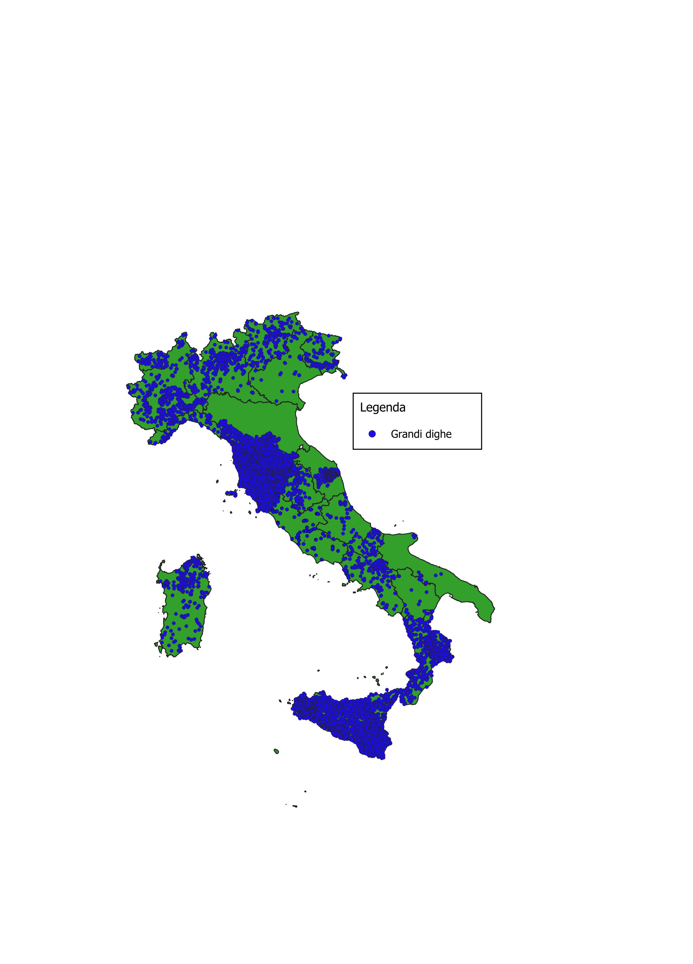
Figure 1: Distribution of large dams under state jurisdiction throughout the country (December 2024) Fonte
ISPRA analysis based on data published by the Ministry of Infrastructure and Transport - Directorate-General for Dams and Water Infrastructure |
Thumbnail
Titolo
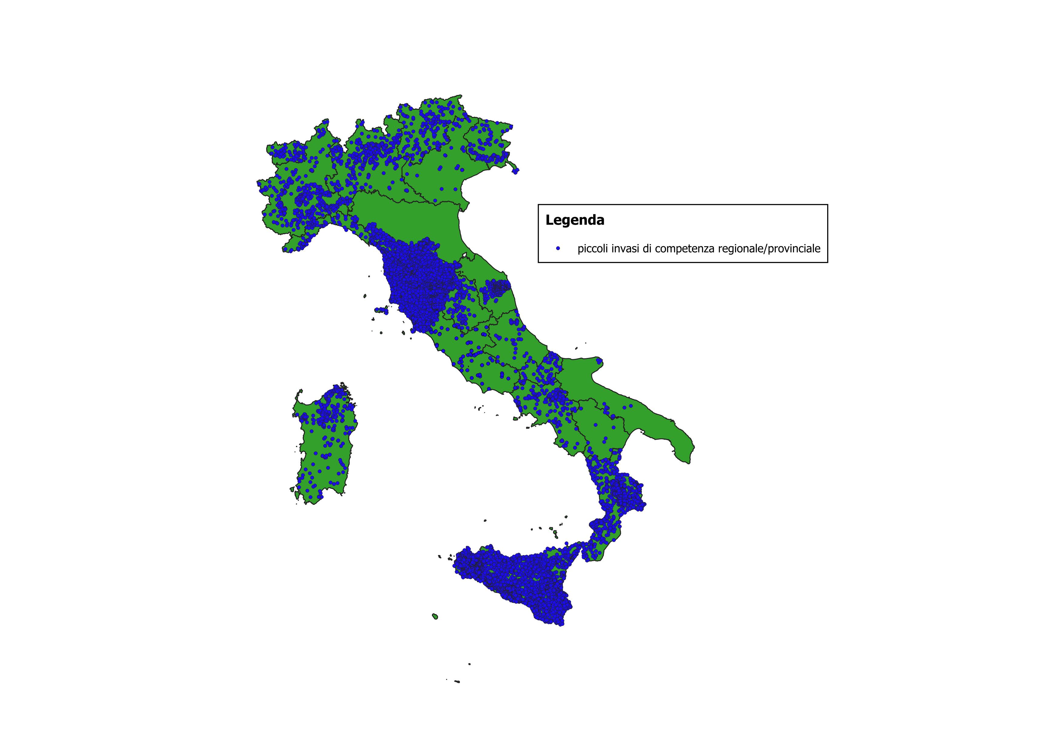
Figura 2: Distribuzione dei Piccoli Invasi di competenza regionale/provinciale Fonte
Elaborazione ISPRA su dati regionali |
The number of Italian Large Dams amounts to 522 (Table 1), with distribution across the entire national territory (Figure 1). For approximately 85% of the Large Dams, the geometries of the water surfaces are available; reservoirs under construction and many of those under Temporary Out-of-Service status are clearly excluded.
In the case of small reservoirs, the estimate also covers the entire national territory, for a total of 41,918 surveyed water bodies. The number of reservoirs reported in Table 2 (column “2025 Estimates and Surveys Provided by the Regions”) corresponds to the figures supplied by the individual Administrations to ISPRA or directly extracted from regional databases accessible online. The other columns in the same table refer to:
Compared with the previous release, additional information on small reservoirs has been retrieved for the Regions of Calabria and Sicily. Furthermore, the reservoirs of the Campania Region were selected on the basis of the attributes contained in the regional .shp files and of the geographical information derived from Google Maps.
The information provided by the online accessible databases, relating to reservoirs under regional jurisdiction, is extremely heterogeneous and in some cases generic; therefore, it is complex, and at times impossible, to discriminate artificial and heavily modified natural reservoirs equipped with dam structures. This is the case for the Regions of Calabria, Tuscany, and Liguria, whose databases contain no indication of lake typology (artificial / natural / heavily modified).
In other cases, it was necessary to process and cross-analyse the information from the various published information layers in order to extract data on small artificial or heavily modified natural reservoirs:
In the case of Sardinia, using the various information layers available on the Regional portal (water bodies, inland wetlands, natural lakes, artificial reservoirs), the dataset containing only lakes with dam structures was extracted; the same procedure was applied to the Lazio Region, whereas the dataset of reservoirs of the Lombardy Region also includes reservoirs with dam structures that are not subject to Regional Law No. 8/1998 on dam safety.
Also for the Regions of Puglia, Basilicata, Abruzzo, and Piedmont, the information made available allowed the selection of reservoirs equipped with dam structures. For the Marche Region, only data for the Province of Macerata are available, while for the Emilia-Romagna Region, information is available on the presence of hill reservoirs with dam structures in four areas (Cesena, Forlì, Ravenna, Rimini), but no geographical information is available.