Aree
AQUACULTURE ENTERPRISES AND PRODUCTION
Data aggiornamento scheda:
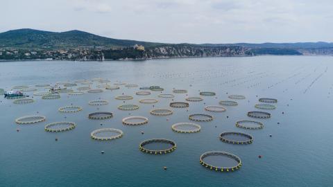
The indicator estimates the scale of national aquaculture in terms of the number of active facilities, production volumes, and growth trends, with reference to the objectives set out in the 2021–2027 Strategic Plan for Aquaculture and in the Operational Programme of the European Maritime, Fisheries and Aquaculture Fund (EMFAF) 2021–2027. Italian aquaculture production recorded for 2023 amounts to 129,746 tonnes, of which 61% consists of molluscs and 39% of fish. Crustacean farming remains a marginal sector, with a production of only 5.4 tonnes. Exotic species account for 45% of total national production.
In 2023, Veneto remains the leading Italian region in terms of number of facilities (23%), while Emilia-Romagna ranks first for production volumes (25%). Five regions (Veneto, Emilia-Romagna, Friuli Venezia Giulia, Sardinia, and Apulia) host 68% of aquaculture facilities. Emilia-Romagna, Veneto, and Friuli Venezia Giulia are confirmed as the main production hubs and, together with Marche and Tuscany, account for 68% of national output. In most coastal regions, brackish/saline water resources prevail, with facilities located in transitional, coastal, and marine environments.
FISHING EXPLOITATION RATE OF NATIONAL FISHERY RESOURCES
Data aggiornamento scheda:
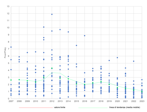
During the period considered (2007–2023), the average exploitation rate of fish stocks — expressed as the mean ratio between current fishing mortality and that corresponding to the Maximum Sustainable Yield (Fcurr/FMSY) — remained generally above the sustainability threshold.
The indicator, derived from analytical stock assessments validated at the international level, describes the overall trend in fishing pressure exerted on commercially exploited stocks.
Within the time series, 2023 stands out as the only year in which the Fcurr/FMSY value fell below the threshold of 1 (0.99), confirming the progressive downward trend observed in recent years for this indicator.
MEAN TEMPERATURE OF THE CATCH (MTC) IN ITALIAN SEAS
Data aggiornamento scheda:
Ocean warming is causing a geographical and depth shift in marine species more sensitive to temperature changes. In temperate zones, such as the Mediterranean, this phenomenon results in a northward expansion of warm-affinity species. Consequently, the composition of marine communities changes, affecting commercial fishery landings.
This phenomenon is described by an indicator known in scientific literature as the “Mean Temperature of the Catch (MTC),” which represents the average thermal affinity of commercial fishing catches. In the Adriatic Sea (FAO Division 37.2.1), the average thermal affinity of the catches of Italian fleets increased from 19.2 °C (average 1987–1996) to 20 °C (average 2013–2023), with a significant annual increase of 0.03 °C; in the Ionian Sea – Central Mediterranean (FAO Division 37.2.2), it increased from 20.3 to 22.2 °C, with a significant annual increase of 0.07 °C; in the Sea of Sardinia – Western Mediterranean (FAO Division 37.1.3), from 20.5 to 22.5 °C, with a significant annual increase of 0.07 °C.
NITROGEN AND PHOSPHORUS BALANCE FROM AQUACULTURE FACILITIES IN THE MARINE ENVIRONMENT
Data aggiornamento scheda:
The indicator provides an estimate of the input and removal of nitrogen and phosphorus, respectively produced by farmed fish and cultivated mussels, in the coastal marine environment where aquaculture activities take place.
The balance between nutrient inputs from farmed fish and nutrient removal by molluscs allows the estimation, at the regional scale, of the net quantitative contribution of aquaculture to trophic processes along the Italian coastline.
At the national level, compared with the 2021–2022 biennium, 2023 shows a reduction in nitrogen and phosphorus inputs, but also a decrease in the removal of these nutrients due to a decline in the production of both marine fish and farmed mussels.
At the regional level, in Veneto, Emilia-Romagna, Abruzzo, Molise and Marche, nitrogen and phosphorus removal by mussels exceeds nutrient inputs from fish farming, owing to the presence of numerous mussel farming facilities and the absence of intensive fish farming activities.
OVEREXPLOITED FISH STOCKS
Data aggiornamento scheda:
Over the period considered (2007–2023), the status of assessed fish stocks has shown an overall improvement: the proportion of nationally managed stocks subject to overfishing has declined, reaching its lowest level (44.4%) in 2023. Although fishing mortality remains critical in several cases, it has exhibited a downward trend in recent years, progressively approaching levels compatible with the long-term sustainable exploitation of resources under average environmental conditions.
The indicator, based on analytically assessed stocks validated at the international level, reflects the overall dynamics of the exploitation status of commercially fished stocks, highlighting the gradual improvement of exploited marine resources. It is also associated with the percentage coverage of landings for which stock assessment data are available, with analyses conducted at both the national and subregional levels according to the geographic subdivision established by the Marine Strategy Framework Directive.
MARITIME SPATIAL PLANNING: MARINE AREAS AND SITES FOR AQUACULTURE
Data aggiornamento scheda:
This indicator reports national scale data on the surface area and number of maritime state concession areas for aquaculture use as well as on Allocated Zones for Aquaculture (AZA). AZAs are designated by the competent authority as “Priority Areas for Aquaculture”, meaning areas free from conflicts with other uses and with environmental conditions suitable to ensure sustainable production while minimizing environmental impacts.
In Europe, identifying new marine areas for aquaculture is one of the main objectives of the Strategic Guidelines for a more sustainable and competitive EU aquaculture for 2021–2030 (COM/2021/236), of the National Strategic Aquaculture Plans 2014–2020 and 2021–2027, and of the corresponding EMFF and EMFAF Operational Programs, under Regulations 508/2014/EU and 1139/2021/EU.
The identification of AZAs is also part of the Maritime Spatial Planning (MSP) framework established by Directive 2014/89/EU, transposed into Italian law by Legislative Decree 201/2016, which supports the sustainable growth of maritime economies through a coordinated, integrated, and cross-border approach within Maritime Spatial Management Plans. These aquaculture planning processes are also relevant to climate change adaptation strategies needed to mitigate medium- and long-term sector impacts.
Italy’s maritime space, between the coastline and the 12-nautical-mile limit, covers approximately 14 million hectares. Of this area, only 20,250 hectares are currently occupied by state concessions for aquaculture use, with around 96% (19,445 ha) allocated to shellfish farming and only 3.9% (805 ha) to marine fish farming. As of April 2024, AZAs have been designated in Tuscany, Marche, Emilia-Romagna, Veneto, and Friuli-Venezia Giulia, for a total area of about 29,633 hectares. Within AZAs, 8,739 ha are occupied by shellfish farming and 665 ha by fish farming.