Maria Paola Campolunghi, Francesco Cardia, Tommaso Petochi
This indicator reports national scale data on the surface area and number of maritime state concession areas for aquaculture use as well as on Allocated Zones for Aquaculture (AZA). AZAs are designated by the competent authority as “Priority Areas for Aquaculture”, meaning areas free from conflicts with other uses and with environmental conditions suitable to ensure sustainable production while minimizing environmental impacts.
In Europe, identifying new marine areas for aquaculture is one of the main objectives of the Strategic Guidelines for a more sustainable and competitive EU aquaculture for 2021–2030 (COM/2021/236), of the National Strategic Aquaculture Plans 2014–2020 and 2021–2027, and of the corresponding EMFF and EMFAF Operational Programs, under Regulations 508/2014/EU and 1139/2021/EU.
The identification of AZAs is also part of the Maritime Spatial Planning (MSP) framework established by Directive 2014/89/EU, transposed into Italian law by Legislative Decree 201/2016, which supports the sustainable growth of maritime economies through a coordinated, integrated, and cross-border approach within Maritime Spatial Management Plans. These aquaculture planning processes are also relevant to climate change adaptation strategies needed to mitigate medium- and long-term sector impacts.
Italy’s maritime space, between the coastline and the 12-nautical-mile limit, covers approximately 14 million hectares. Of this area, only 20,250 hectares are currently occupied by state concessions for aquaculture use, with around 96% (19,445 ha) allocated to shellfish farming and only 3.9% (805 ha) to marine fish farming. As of April 2024, AZAs have been designated in Tuscany, Marche, Emilia-Romagna, Veneto, and Friuli-Venezia Giulia, for a total area of about 29,633 hectares. Within AZAs, 8,739 ha are occupied by shellfish farming and 665 ha by fish farming.
The indicator measures the use of marine space along the Italian coast through two allocation mechanisms:
- Maritime state concessions issued for aquaculture facilities;
- Allocated Zones for Aquaculture (AZA), identified by competent authorities through maritime spatial planning processes at local, regional, or national levels that meet administrative, environmental, and socio-economic suitability criteria for aquaculture development (GFCM, 2012).
The indicator is based on regional maritime boundaries relevant to marine-coastal aquaculture and excludes transitional waters. Concession and AZA data are processed as polygon shapefiles using Geographic Information Systems (GIS), with attribute tables including data on area (surface and perimeter), cultivated species, and references to the relevant concession decrees.
To provide information on marine areas currently used or potentially available for aquaculture, in order to assess progress toward sectoral growth and development objectives. The indicator supports Maritime Spatial Management Plans (Directive 2014/89/EU), facilitating evaluation of integrated sea uses and progress towards strategic sectoral objectives.
It allows for tracking changes over time in marine space allocation for aquaculture in Italy at both regional and maritime subregional scales.
Resolution 36/2012/1 of the FAO General Fisheries Commission for the Mediterranean (GFCM) promotes aquaculture as a resource for food security and socio-economic development in coastal areas, committing member states to plan and allocate marine space for aquaculture. It introduces and defines AZA (Allocated Zone for Aquaculture) and its establishment and management principles.
Marine space access is recognized as a limiting factor for aquaculture development. The European Commission's Strategic Guidelines for a More Sustainable and Competitive EU Aquaculture 2021–2030 (COM/2021/236 final) identify AZAs as a key objective for Member States’ National Strategic Aquaculture Plans to promote sustainable aquaculture development.
Improving the use of coastal marine space and designating new AZAs is a goal of both the EMFF 2014–2020 (Reg. 508/2014/EU) and EMFAF 2021–2027 (Reg. 1139/2021/EU).
AZA establishment is integrated within the broader Maritime Spatial Planning (MSP) process aimed at fostering sustainable maritime development in Europe, as defined by Directive 2014/89/EU, transposed into Italian law by Legislative Decree 201/2016 and implemented by Ministerial Decree No. 237 of 25/09/2024 approving Maritime Spatial Plans (https://www.sid.mit.gov.it/). The Directive requires Member States to develop management plans for their jurisdictional waters through mapping existing human uses, with special focus on key Blue Growth sectors such as aquaculture.
The indicator is also relevant to global and European strategic objectives for energy transition, sustainable development, climate neutrality, and biodiversity protection (UN 2030 Agenda; European Green Deal and Farm to Fork Strategy 2020–2030; Biodiversity Strategy 2030).
Bolognini L., Grati F., Marino G., Punzo E., Scanu M., Torres C., Hardy P.Y., Piante C. (2019). Safeguarding Marine Protected Areas in the growing Mediterranean Blue Economy.
Borovac, A., Jelagat Kipyator, M., Gosselin, B., (2024): “Aquaculture’s Vital Role in
Advancing the Sustainable Development Goals: A Comprehensive Overview”. Siena:
Sustainable Development Solutions Network – Youth Mediterranean (SDSN Youth
Mediterranean).
Recommendations for Aquaculture. PHAROS4MPAs project. 52 pages. https://maritime-spatial-planning.ec.europa.eu/sites/default/files/aquaculture_31july_0.pdf; COM (2019) 640 final.
Campolunghi, M. P., Petochi, T., Cardia, F., Calise, G., Ciani, M., Marino, G., 2023. Atlante AZA Campania: Studi di vocazionalità per l’assegnazione di nuove zone marine per l’acquacoltura. ISPRA, Pubblicazioni di pregio. ISBN 978-88-448-1185-3. https://www.isprambiente.gov.it/public_files/ATLANTE_AZA_CAMPANIA_HR.pdf.
The State of World Fisheries and Aquaculture (SOFIA). Towards Blue Transformation. Rome, FAO. https://doi.org/10.4060/cc0461en; GFCM (2012).
Marino G., Petochi T., Cardia F. (2020). "Assegnazione di Zone Marine per l'Acquacoltura (AZA). Guida Tecnica", 214 p. ISPRA Documenti Tecnici 2020. ISBN 978-88-448-1014-6.
https://www.isprambiente.gov.it/it/pubblicazioni/documenti-tecnici/assegnazione-di-zone-marine-perlacquacoltura-aza-guida-tecnica; MiPAAF-ISPRA (2014). Piano Strategico per l’Acquacoltura in Italia (2014-2020). pp.282.
https://pofeamp.politicheagricole.it/documents/17/2_Programma_operativo_Feamp.pdf; MiPAAF-CREA (2021) Piano Strategico per l'Acquacoltura italiana (2021-2027). 154 p.;
Petochi, T., Campolunghi, M. P., Cardia, F., Marino, G., 2022. Atlante AZA Lazio: Studi di vocazionalità per l’assegnazione di nuove zone marine per l’acquacoltura. ISPRA, Pubblicazioni di pregio. ISBN 978-88-448-1189-1.
Progetto AZA Lazio (PO-FEAMP, 2014-2020, Misura 2.51, Determinazione Regione Lazio n. G17128 del 20.12.2018).
In some cases, inconsistencies between data sources have resulted in misalignment of polygon geometries defining concession areas.
Data updates aimed at aligning the databases following the ongoing maritime spatial planning process. This will allow the indicator to better describe trends in marine space occupation for aquaculture use (number and area of concessions), as well as trends in integration of aquaculture into maritime spatial planning (number and area of AZAs), providing a dynamic picture of marine aquaculture development.
Comuni
ISPRA
Regioni
- Web app @AquaGIS (https://sinacloud.isprambiente.it/portal/apps/sites/#/acquacoltura-1)
- Portale SID - Sistema Informativo del Demanio Marittimo (https://www.sid.mit.gov.it)
- Ordinanze delle Capitanerie di Porto (https://www.guardiacostiera.gov.it/normativa-e-documentazione/ordinanze)
- Decreti delle Giunte Regionali (BUR regionali)
- Mappe Nautiche Navionics (https://webapp.navionics.com/)
National
Regional (coastal regions 15/15)
2024
Analyses leading to the indicator's definition are carried out using Geographic Information Systems (GIS). When base data derive from textual documents containing coordinates of polygons that delimit areas designated for aquaculture (both concessions and AZAs), these are georeferenced, converted into shapefiles, and complemented with attribute tables populated with descriptive information on geometries, including surface area.
The indicator is calculated by summing the surfaces (in hectares) of all polygons in the 15 coastal regions, distinguishing between shellfish and fish farming. The indicator is also presented in aggregated form for the three maritime subregions: Adriatic Sea, Ionian and Central Mediterranean Sea, and Western Mediterranean Sea.
The status is assessed based on trends in the number and surface area of concessions for shellfish and fish farming and the number and area of AZAs identified across Italy’s 15 coastal regions.
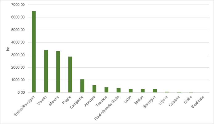
Italy’s maritime space under jurisdiction extends from the coastline to the 12-nautical-mile limit, covering approximately 14 million hectares. Of this, 20,250 ha are currently allocated for aquaculture (both shellfish and fish farming).
Shellfish farming occupies approximately 96% of this area, totaling 19,445 ha.
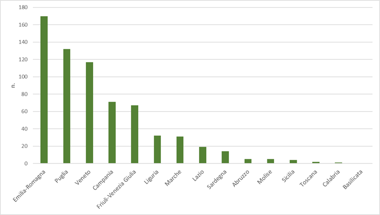
The Emilia-Romagna region hosts 170 concessions and has the largest area dedicated to shellfish farming (6,504 ha, representing 33.3% of the national shellfish farming area).
It is followed by:
- Marche with 31 concessions (3,290 ha; 16.8%),
- Puglia with 132 concessions (2,873 ha; 14.7%),
- Veneto with 117 concessions (3,398 ha; 17.4%),
- Campania with 71 concessions (1,054 ha; 5.4%).
Abruzzo, Tuscany, Friuli-Venezia Giulia, Lazio, and Sardinia have concessions covering hundreds of hectares.
Other regions have smaller areas dedicated to shellfish farming:
Liguria, Calabria, and Sicily have 32, 1, and 4 active concessions respectively, covering 52 ha, 48 ha, and 33 ha (approximately 0.2%, 0.2%, and 0.1%). Basilicata has no shellfish farming concessions.
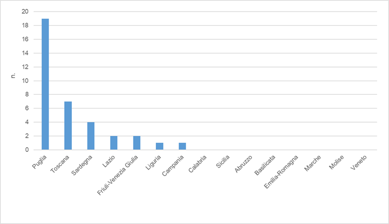
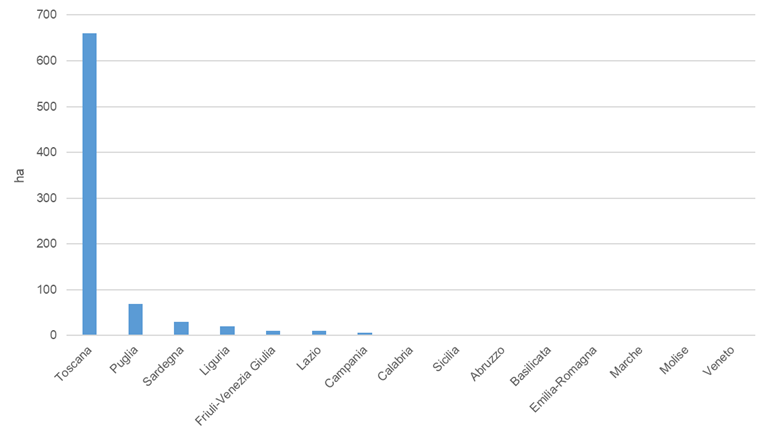
Marine fish farming occupies the remaining 3.9% of the space dedicated to aquaculture, covering 805 hectares.
Currently, Tuscany has 7 concessions covering 659 ha, equivalent to 52% of the total marine fish farming area in Italy. Lazio and Puglia follow with 2 and 19 concessions respectively, covering 10 ha and 68 ha (1.24% and 8.4%). Sardinia, Liguria, Campania, and Friuli-Venezia Giulia have smaller areas of tens of hectares. Abruzzo, Basilicata, Calabria, Emilia-Romagna, Marche, Molise, Sicily, and Veneto have no concessions for marine fish farming.
As for AZAs, these have been designated in only five regions:
- Marche: 15 zones (approx. 13,700 ha),
- Emilia-Romagna: 6 zones (4,281 ha),
- Tuscany: 1 zone (1,499 ha),
- Veneto: 10 zones (9,805 ha),
- Friuli-Venezia Giulia: 8 marine zones (318 ha).
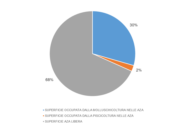
The total area identified as AZAs in these five regions amounts to 29,633 ha. Of this, 29.4% is already occupied by shellfish farming (8,739 ha), and 2.2% by fish farming (665 ha).
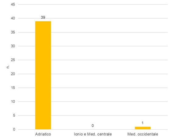
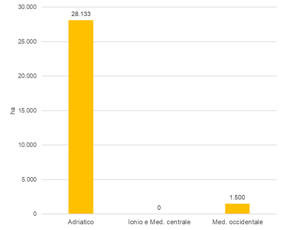
The indicator is also presented in aggregated form for the three maritime subregions defined by Directive 2014/89/EU:
- Adriatic Sea: 39 AZAs, totaling 28,133 ha;
- Western Mediterranean Sea: 1 AZA, 1,499 ha;
- Ionian and Central Mediterranean Sea: no AZAs designated yet.
Based on the current data, the indicator is rated at a medium level due to the limited percentage of marine space allocated to aquaculture (approximately 0.14%) and the presence of AZAs in only 5 out of 15 coastal regions. Despite ongoing regional disparities, the identification of nearly 30,000 hectares of AZAs represents a concrete first step towards a more structured and sustainable development of marine aquaculture in Italy.
No historical data series is currently available to establish a trend.
| Allegati |
|---|
Thumbnail
|
Titolo
Table 1: Number and extent of AZAs (2024) Fonte
ISPRA processing of data extracted from regional BURs Legenda
AZAs: Allocated Zones for Aquaculture |
Thumbnail
Titolo
Figure 1: Number of shellfish concessions in state-owned areas by region (2024) Fonte
ISPRA processing of SID data - Port Captaincies Ordinances - Regional BUR |
Thumbnail
Titolo
Figure 2: Extent in hectares of shellfish concessions in state-owned areas by region (2024) Fonte
ISPRA processing on SID data - Port Captaincies Ordinances - Regional BUR. |
Thumbnail
Titolo
Figure 3: Number of fish farming concessions in state-owned areas by region (2024) Fonte
ISPRA processing of SID data - Port Captaincies Ordinances - Regional BUR |
Thumbnail
Titolo
Figure 4: Extent in hectares of fish farming concessions in state-owned areas by region (2024) Fonte
ISPRA processing on SID data - Port Captaincies Ordinances - Regional BUR |
Thumbnail
Titolo
Figure 5: Area of AZAs already occupied by shellfish farming and fish farming (2024 Fonte
ISPRA processing on SID data - Port Captaincies Ordinances - Regional BUR |
Thumbnail
Titolo
Figure 6: Number of AZAs in the Adritic, Ionian, and Med. subregions. Central and Med. West (2024) Fonte
ISPRA processing on data extracted from regional BURs |
Thumbnail
Titolo
Figure 7: Extent of AZAs in the Adriatic, Ionian, Med. Central and Med. West subregions (2024) Fonte
ISPRA processing of data extracted from regional BURs |
The identification of AZAs is part of the Maritime Spatial Planning (MSP) process, which defines current and future uses of coastal and offshore waters.
The national management plan, originally due by 2021 for the three Mediterranean maritime subregions (Adriatic Sea, Ionian and Central Mediterranean Sea, Western Mediterranean Sea), was adopted on 25 September 2024 by Ministerial Decree No. 237. The plan officially allocates marine space to different productive sectors of the "maritime system", including aquaculture.
Currently, Tuscany, Marche, Emilia-Romagna, and Friuli-Venezia Giulia have formalized AZAs, although prior to the adoption of the national MSP plan and outside an integrated, coordinated MSP process required by Legislative Decree 201/2016. Veneto designated AZAs in 2024 with Regional Government Resolution No. 1115 of 23 September 2024.
Other regions have initiated preparatory actions for AZA identification:
Abruzzo, Calabria, Liguria, and Puglia have initiated EMFF-supported actions for AZA identification.
Currently, the AZA indicator refers only to the five regions that have formally designated them, while aquaculture concession data covers all 15 coastal regions.
The integration of aquaculture into maritime spatial planning is particularly relevant given the increasing pressures on coastal and marine ecosystems — including transitional waters — threatened by pollution, habitat alteration, and resource overexploitation. While aquaculture represents a growing sector with high potential for food security, economic development, and employment, its expansion requires integrated approaches that ensure environmental sustainability, prevent use conflicts, and provide regulatory clarity.
In this context, in 2024, ISPRA and FAO organized the international workshop Spatial management for aquaculture planning: defining needs for assisting countries, aimed at identifying priority actions to effectively integrate aquaculture into maritime and coastal spatial planning frameworks. The workshop involved 28 international experts who shared experiences and best practices in spatial planning applied to aquaculture, identifying challenges, available tools, location criteria, and effective governance mechanisms.
The workshop provided a valuable opportunity for dialogue, promoted institutional synergies, and defined a shared roadmap to improve aquaculture integration into spatial management policies. Its outcomes will contribute to developing technical guidelines and operational tools under the FAO Strategic Framework 2022–2031 to support countries in achieving sustainable sector growth while respecting ecosystems and coastal communities.