Aree
ARTIFICIAL RESERVOIRS
Data aggiornamento scheda:
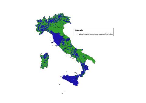
The number of reservoirs classified as Large Dams, pursuant to Law No. 584 of 21 October 1994 and the subsequent Ministry of Public Works Circular No. 482/1995, amounts to 522 (December 2024). Based on the surveys provided by the Regions and/or retrieved online up to September 2025, the total number of water bodies (artificial reservoirs, tanks, natural lakes, ponds, wetlands, etc.) is 41,918.
For Large Dams, information is complete at the national level. For small reservoirs under regional jurisdiction, census data or estimates are available for all Regions; however, in some cases these data are partial and incomplete, and it is estimated that at least 35% of them are equipped with dam structures.
ITALIAN LANDSLIDE INVENTORY (IFFI)
Data aggiornamento scheda:
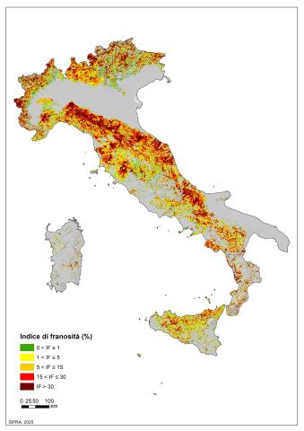
The indicator provides information on the number and distribution of landslides in Italy. More than 636,000 landslides have been recorded (reference period 1116–2025), affecting an area of over 25,100 km², equivalent to 8.3% of the national territory.
MAIN LANDSLIDE EVENTS
Data aggiornamento scheda:
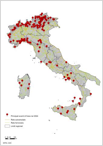
The indicator provides information on the main landslide events that caused fatalities, injuries, evacuations, and damage to buildings, cultural heritage assets, primary linear communication infrastructures, and service networks across the national territory over the past year. In 2024, there were 185 major landslide events, resulting in 5 deaths, 18 injuries, and predominantly causing damage to the road network and buildings.
VOLCANIC ERUPTIONS
Data aggiornamento scheda:
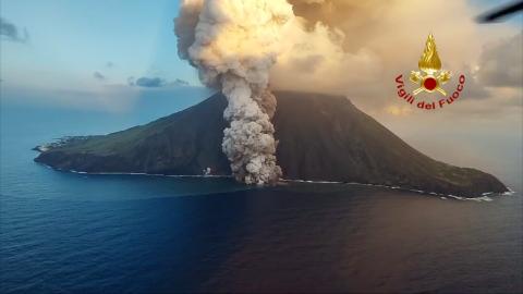
The indicator is defined as the number of volcanic eruptions that produced significant impacts on human activities during the year.
In 2024, both Etna and Stromboli were active, with the most pronounced peaks occurring between July and August.
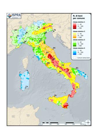
CULTURAL HERITAGE EXPOSED TO LANDSLIDES AND FLOODS
Data aggiornamento scheda:
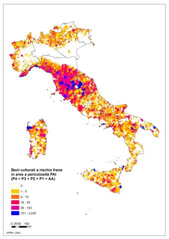
The indicator provides information relating to cultural heritage at hydrogeological risk on the national territory. There are 45,339 cultural assets at risk of landslides, of which 13,966 are located in areas with high P3 and very high P4 danger. The cultural assets at risk of flooding are 35,997 in the medium hydraulic danger scenario (return times between 100 and 200 years) and reach 54,103 in the low hydraulic danger scenario, which is the maximum expected scenario.
LANDSLIDE HAZARD AREAS
Data aggiornamento scheda:
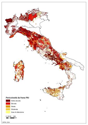
The indicator provides information on the landslide-prone areas of the Hydrogeological Management Plans (PAI) on the national territory. The total surface area, in Italy, of the PAI landslide hazard areas and the areas of attention is equal to 69,530 km 2 (23% of the national territory), of which 28,801 km 2 (9.5%) are areas of high P3 and very high P4 danger, subject to the most restrictive land use constraints.
POPULATION EXPOSED TO LANDSLIDES
Data aggiornamento scheda:
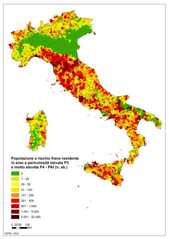
The indicator provides an estimate of the population at risk of landslides (risk of personal injury: dead, missing, injured, evacuated) on a national, regional, provincial and municipal basis. In Italy, the population at risk of landslides residing in areas with high and very high PAI danger (P3+P4) amounts to 1,284,960 inhabitants, equal to 2.2% of the total.
AREAS SUBJECT TO SINKHOLES
Data aggiornamento scheda:
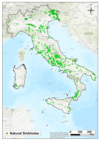
Sinkholes are depressions that open suddenly in the ground, with a sub-circular shape and variable diameter and depth, ranging from a few meters to hundreds of meters.
The inventory of sinkholes and the identification of at-risk areas are useful for studying the susceptibility of the territory to hydrogeological instability.
As of April 2025, more than 15,000 cases of natural sinkholes have been recorded and studied by ISPRA in lowland areas, plateaus, or foothill zones. Detailed on-site inspections and analyses have been conducted on hundreds of these cases.
Areas susceptible to natural sinkholes are concentrated on the central Tyrrhenian side, particularly in Friuli-Venezia Giulia, Lazio, Puglia, Abruzzo, Campania, and Tuscany.
The Adriatic side, especially the Marche region, due to its geological-structural features, is less affected by such phenomena, as are the Alpine Arc and the Dolomites, except for Friuli-Venezia Giulia and the Veneto plateaus.
Anthropogenic sinkholes constitute another category, as they are connected to underground cavities created by humans (anthropogenic sinkholes), mostly for the extraction of construction materials. Many cities are affected by this phenomenon, especially large urban areas built on land previously used for mining activities, such as Rome, Naples, Cagliari, Palermo, Reggio Calabria, and Turin. Thousands of cases have also been recorded in small and medium-sized towns with widespread underground networks. As of 2024, approximately 4,500 anthropogenic sinkholes have been recorded in Rome, over eight hundred in Naples, and several hundred in Cagliari and Palermo.
EVENTI SISMICI
Data aggiornamento scheda:
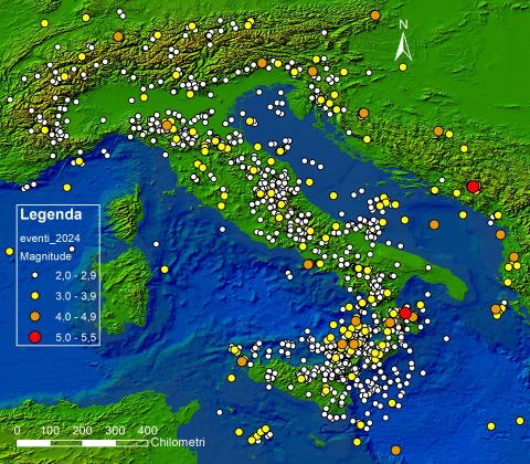
The indicator describes seismic events that occurred in Italy during the reference year, based on Magnitude values recorded by the National Seismic Network of INGV. In 2024, no destructive earthquakes occurred in Italy. Only one event reached Magnitude 5 in the province of Cosenza, which nonetheless caused no significant surface effects. Additionally, 13 events with Magnitudes between 4 and 4.6 were recorded within Italian territory and across borders up to 100 km away. The number of earthquakes with Magnitude ≥ 2 in 2024 (2,031) is comparable to the number recorded in the previous five years, with a slight decrease in 2021. As usual, most events were concentrated along the Apennine arc, the Eastern Alps, and Eastern Sicily.
CULTURAL HERITAGE EXPOSED TO SEISMIC HAZARD
Data aggiornamento scheda:
As of December 31, 2024, 16,729 cultural heritage sites are located in municipalities classified as areas with a high probability of strong earthquakes, representing 7.3% of the total cultural heritage.
CULTURAL HERITAGE EXPOSED TO VOLCANIC HAZARD
Data aggiornamento scheda:
The cultural heritage sites located within the high-hazard zone estimated by ISPRA amount to 4,948, representing 2% of the total, while those within the moderate-hazard buffer total 7,601, accounting for 3.3% of Italy’s cultural heritage (229,530 sites).
EXPOSURE TO SEISMIC AND GEOLOGICAL-HYDRAULIC HAZARDS OF ARTIFICIAL RESERVOIRS
Data aggiornamento scheda:
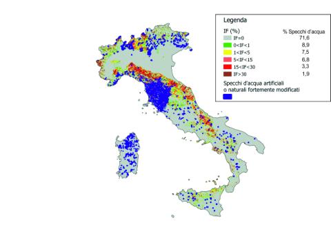
The indicator analyzes the distribution of large and small dams in relation to the seismic classification of the national territory (Map of seismic zones OPCM March 20, 2003, n. 3274 and subsequent integrations), the Landslide Index of the IFFI Project (Italian Landslide Inventory), and the distribution of landslide-prone areas. For the year 2024, the indicator shows that the water surface of artificial and heavily modified natural lakes (the water perimeter for large and small dams) in areas with a null Landslide Index (IF) constitutes 71.6%, while only 1.8% falls in areas with a higher IF (IF>30). In terms of seismic activity, 7.4% of large dams and 2.2% of small dams are are located in the most dangerous area (seismic zone 1), while 20.6% and 11.9%, respectively, are in the least dangerous area (seismic zone 4). Due to incomplete data on the distribution of small reservoirs at the national level, the result is considered partial.
FLOOD EVENTS
Data aggiornamento scheda:
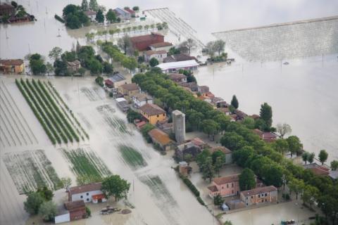
In 2023, Italy experienced one of the hottest years in the last 150 years, second only to 2022. The average and maximum temperatures reached new records with October recording temperatures more than 3°C higher than the 1991-2021 average, marking the highest value since 1961. During the summer, intense heatwaves affected the country, with record temperatures of 48.2°C recorded on July 24 in Jerzu and Lotzorai in Sardinia, and 41.2°C in Rome in early August. Drought continued to be a significant problem, with Northern and Central Italy experiencing severe drought conditions in the first four months of the year, which later eased. However, in the last three months of the year, Sicily and parts of Ionian Calabria suffered from extreme drought with a significant precipitation deficit.
Extreme weather events affected several regions, causing severe damage. In May, Emilia-Romagna was devastated by two exceptional rainfall events, leading to flooding, landslides, and 17 fatalities. On November 2, heavy thunderstorms in Tuscany caused flooding and 8 deaths, with exceptional rainfall recorded in the provinces of Pisa, Livorno, Pistoia, and Prato.
In summary, 2023 was characterized by record temperatures, persistent drought, and extreme weather events that had a significant impact on various italian regions.
SUBSIDENCE-AFFECTED MUNICIPALITIES
Data aggiornamento scheda:
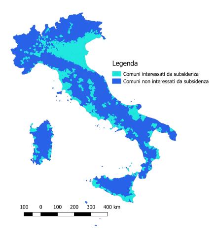
According to the collected data, subsidence affects approximately 18% of Italian municipalities, primarily in Northern Italy, particularly in the Po Valley. In Central and Southern Italy, the phenomenon mainly affects coastal plains. The most affected regions are Veneto and Emilia-Romagna, where over 50% of municipalities experience subsidence.
ENVIRONMENTAL EFFECTS OF EARTHQUAKES
Data aggiornamento scheda:
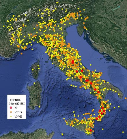
The indicator describes the environmental effects induced by earthquakes and represents the susceptibility of the Italian territory to such effects. Susceptibility depends on the varying degrees of seismicity present in different portions of the Italian territory and the local geomorphological and geological characteristics. It also provides a map of the ESI (Environmental Seismic Intensity) values reached during known seismic history in Italy, representative of the effects that may occur again in the future due to similar earthquakes.
In 2022, only one earthquake was recorded in which seismic-induced environmental effects were reported. This was the earthquake that occurred on December 4, 2022, in the Aeolian Islands, with a magnitude of 4.5, which induced modest collapse phenomena in some sites on Lipari and Vulcano.
FLOOD HAZARD AREAS
Data aggiornamento scheda:
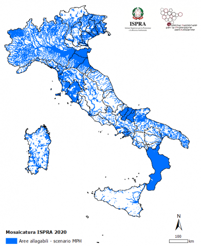
The indicator provides information on the flood hazard conditions for the entire national territory, updated to 2020. Areas with high hydraulic hazard, prone to flooding with a return period between 20 and 50 years, account for 5.4% of the national territory (16,224 km²). Areas with medium hydraulic hazard, prone to flooding with a return period between 100 and 200 years, represent 10% (30,196 km²). Areas with low hydraulic hazard, prone to flooding during rare or extreme events, make up 14% of the national territory (42,376 km²).
POPULATION EXPOSED TO FLOODS
Data aggiornamento scheda:
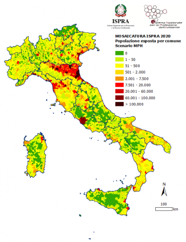
This indicator provides an overview of the population residing in flood-prone areas (population exposed to flood risk) at the national, regional, provincial, and municipal levels. In Italy, the population residing in areas with high hazard/probability is 4.1% of the total national population (2,431,847 people); those exposed to medium hazard/probability are 11.5% (6,818,375 people), while the population in areas with low hazard/probability is 20.6% (12,257,427 people).
SURFACE FAULTING (CAPABLE FAULTS)
Data aggiornamento scheda:
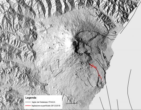
The indicator provides information on surface faulting events associated with the reactivation of capable faults in Italy. These faults typically become active during strong earthquakes, but also in response to earthquakes with relatively low magnitudes if they are shallow, as occurs in volcanic-tectonic contexts, such as in the Etna region. Specifically, following the Fleri earthquake of December 26, 2018 (Mw 4.9, H = 1 km; INGV), the Fiandaca - Acicatena - Aciplatani fault system was reactivated, as it had been in the recent past.
Surface faulting along the Fiandaca fault was documented over a length of approximately 5 km. The rupture along the Aciplatani fault, however, was not co-seismic, but appeared several hours after the seismic event, with cracks opening a few centimeters that, after a few days, reached a total length of about 700 meters. These aseismic movements, known as creep, are common in some sectors of the Etna apparatus.
The damage related to the seismic event was primarily localized along the surface faulting zones, which had been affected by the same phenomenon multiple times in the past, including very recently. This highlights the importance of identifying areas with capable faults and considering them in land-use planning.
The faults reactivated in 2018 were already included in the ITHACA database, the inventory of capable faults in Italy developed by ISPRA, which provides the current state of knowledge about the distribution of faults in the national territory that are potentially capable of causing surface faulting.
SURFACE FAULTING INDEX IN URBAN AREAS
Data aggiornamento scheda:
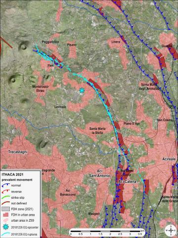
The indicator provides an estimate of the level of exposure of urban areas to surface faulting hazards. For each seismogenic zone in the ZS9 zoning, the indicator measures the areal extension of urbanized areas exposed to surface faulting hazards due to their proximity to capable faults (ITHACA Catalog). These faults are delineated considering the predominant kinematics of the fault, with an extension that depends on the maximum expected displacements.
The most critical situations are confirmed in eastern Sicily, particularly in the Etna area. A comparison with the last assessment (in 2014) shows an increase attributable to the greater expansion of urban areas near capable faults, as well as to the higher number of capable faults included in ITHACA, due to the progressive improvement in knowledge about the recent tectonic activity of certain structures.