REGIONAL COASTAL MANAGEMENT PLANS
Data aggiornamento scheda:
The indicator is the result of the regional recognition of the state of planning relative to the coastal strip. 11 coastal regions out of 15 have regional planning tools extended to the management and protection of the coastal territory and some are preparing a second regional plan, distinguishing with greater clarity that intended for the protection and protection of the coasts from that oriented to the development and coordination of socio-economic activities.
The analysis of the indicator shows in recent years an overall acceleration of the planning processes and, although not measurable by the indicator, numerous initiatives to update and refine the tools already adopted. The reason for this increased activity is believed to be partly linked to the growing sensitivity to the erosion problem, and partly to depend on the introduction into the basin planning of the Flood Risk Management Plan, which requires the assessment of danger and risk for coastal flooding.
COASTAL DYNAMICS
Data aggiornamento scheda:
The indicator provides the national and regional estimate of the state conservation of Italian coasts in 2020 and of the changes due to erosion or progress suffered since 2006, useful for the assessment of the vulnerability of coastal areas and the risk to which urban centers, infrastructure and socio-economic activities that develop near the coast are exposed. In 2020 there was a significant instability over 1,913 km of coastline, of which 943 km for erosion and 970 km for advance, however, compared to the previous surveys (1950-2000, 2000-2006), there is a slight trend to greater stability and an increase in the stretches of coast in progress.
DREDGED SEDIMENTARY SANDS FOR BEACH NOURISHMENT PURPOSES
Data aggiornamento scheda:
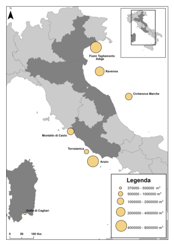
In Italy, the coasts, which develop for over 8,000 km, represent an important strategic resource: they are among the most densely populated areas and home to intense economic activity. The increasing exploitation to which these areas are subjected, associated with natural events (e.g. global climate change), has led to an increase in erosion phenomena. To counteract these processes and to protect housing and infrastructure, over the years numerous rigid defense works have been carried out in several coastal regions (surfaces emerged, submerged, grazing, mixed works, piers, brushes), not always with satisfactory results. An alternative technique that could guarantee a good response to coastal erosion, from an environmental and economic point of view, is replenishment. The replenishment consists in reconstructing the eroded beach by entering suitable sediments (from the granulometric and compositional point of view). A possible response to the need to supply material to be used for replenishment has been identified in the use of relict marine sands (referenced to paleopiagge) from sandy deposits present offshore on the continental shelf. The first dredging of rewashed sands for replenishment began in 1995 in the northern Adriatic Sea (Veneto). Subsequently, other dredgings have affected both other quarries located in the Adriatic Sea (off Emilia-Romagna and Marche) and both quarries located in the Tyrrhenian Sea (off the coast of Sardinia and Lazio).
ARTIFICIAL COASTLINE WITH MARITIME AND COASTAL DEFENSE STRUCTURES
Data aggiornamento scheda:
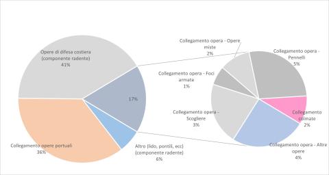
The indicator provides a measure of coastal engineering interventions that directly alter geomorphology, coastal dynamics and often the natural character of long stretches of coast. The reference data for the calculation of the indicator concern three main aggregations within which the various types of works can be grouped: the port infrastructures, the coastal defense works built near the shore and the set of the other differently characterized structures, which however retain the peculiarity of being leaning against the coastline. The elaborations led to the creation of graphs useful to assess the situation in 2020 of the national coastal artificialization and the variation that took place with reference to the years 2000, 2006 and 2020. In general terms, there is an increase in artificialization ranging from 696 km in 2000, to 714 km in 2006, to 770 km in 2020 (about 8,300 km of national coast), mainly due to the growth of port works and coastal defense works grazing on the coast.
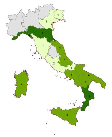
COASTAL PROTECTION STRUCTURES
Data aggiornamento scheda:
To contain erosion and damage caused by storms along the Italian coasts, defense interventions are often carried out aimed at protecting goods and infrastructure and restoring beaches. The indicator “coastal defense works” provides the number, on a national and regional basis, of the different types of “rigid” works of coastal defense (islots, mixed works, brushes, grazing and cliffs) and their variation over time. From 2000 to 2020, if on the one hand it was possible to find an increase in the number of rigid defense works (from about 6,600 to 10,500) indicative of the fragility of coastal environments subjected to increasing anthropogenic pressure; on the other hand, the increasing adoption of submerged or partially emerged defense solutions (from 10% in 2006 to 16% in 2020) shows the trend towards the search for a compromise between the hydraulic efficiency of a lesser impact.
PROTECTED COASTLINE
Data aggiornamento scheda:
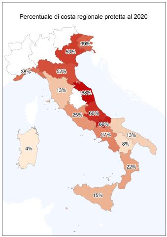
To contain the erosion of the coasts and the damage produced by the storms over the years, numerous interventions have been carried out along the Italian coasts, aimed at protecting the assets and infrastructure present in the immediate hinterland and the restoration of the backward beaches. The indicator provides an estimate on a national and regional basis of the protected coast with rigid works, the measure is representative of both the fragility of the coastal environments of the country and the management and protection costs from the hydrogeological instability of coastal areas.
18% of the Italian coasts, equal to about 1,520 km, are protected with defense works and the action to combat erosion does not stop; from the relief of the state of the coast to 2020 it appears that between 2008 and 2020 new works have been carried out to protect a further 200 km of coastline.