Angela Barbano, Laura Sinapi
The indicator is the result of the regional recognition of the state of planning relative to the coastal strip. 11 coastal regions out of 15 have regional planning tools extended to the management and protection of the coastal territory and some are preparing a second regional plan, distinguishing with greater clarity that intended for the protection and protection of the coasts from that oriented to the development and coordination of socio-economic activities.
The analysis of the indicator shows in recent years an overall acceleration of the planning processes and, although not measurable by the indicator, numerous initiatives to update and refine the tools already adopted. The reason for this increased activity is believed to be partly linked to the growing sensitivity to the erosion problem, and partly to depend on the introduction into the basin planning of the Flood Risk Management Plan, which requires the assessment of danger and risk for coastal flooding.
The indicator is the result of the regional reconnaissance of the state of planning for the coastal strip.
The most recent planning tools highlight clear attempts at an integrated approach to coastal territorial planning, making explicit reference to the Integrated Coastal Zone Management (GIZC), as proposed in the Recommendation of the European Parliament no. 2002/413/EC of 30/05/02 and in the VII Protocol to the Barcelona Convention for the Mediterranean Sea.
The Community policies for marine and coastal areas are extremely complex: among the reference directives we can mention the Framework Directive on Marine Strategy, the Water Framework Directive, the Flood Directive, the Habitats Directive and the Maritime Space Planning Directive. The European Community is also committed to the Strategy for Biodiversity and the Adaptation Strategy for Climate Change; as well as on the development of the Integrated Maritime Policy.
The coastal strip is the area subjected to greater pressures determined by demographic and development factors, accepting interests deriving from terrestrial and maritime resources: however, there are no nor Community nor national rules that prescribe the definition of a specific plan for coastal areas, although there are many acts in which the need for instruments for environmental protection and for the management of anthropic actions that act in these areas is recalled.
This determines that each entity responsible for administering the coastal area provides in the manner it deems most suitable, following different paths and objectives, and that the instruments developed are of various kinds.
For the indicator, excerpt plans drawn up by the Authority of the Basin have been recorded, safeguards issued pending the ardigend plans, territorial coordination plans of the coast (Liguria), landscape plans (Sardinia); in some cases, as for Lazio and Tuscany, also programs of economic and tourist development of the regional coast, as, however, planning acts related to the coastal sphere.
Define the state of coastal belt planning, as an area under increased pressures caused by demographic and development factors. Through its elaboration, it is possible to identify and differentiate the answers provided by the regions to the problems related to the management of coastal areas.
The competences inherent in the defense and integrated management of the coasts were entrusted to the regions with the L 59/97, Legislative Decree 112/98 and Legislative Decree 86/99, which confer and govern the functions and administrative tasks of the State to the regions and local authorities.
The regions, according to the provisions of Legislative Decree 112/98 (Article 89 paragraph 1 letter h), and the Basin Authorities (now of District), according to those of L 183/89 and the subsequent DL 180/98, and D. Legislative Decree 152/2006 and subsequent amendments, have promulgated rules and drafted plans and programs for the protection and defense of the coasts.
Legislative Decree 49/2010, which transposes the Flood Directive, establishes the obligation to draw up the Flood Risk Management Plans, which have the task among others of evaluating the danger and risk from coastal flooding, with the possibility of defining measures for the relative mitigation.
Further objectives are defined in the Recommendation of the European Parliament no. 2002/413/EC of 30/05/02 and in the Protocol of Integrated Management of Coastal Areas (GIZC) of the Mediterranean, adopted on 21 January 2008, also signed by the European Union, and entered into force on 24 March 2011. On December 19, 2023, the Council of Ministers approved the Design of Ratification Law and implementation of the Protocol on the Integrated Management of the Mediterranean Coastal Zones. The measure in question, of government initiative and already approved by the Senate in the session of March 26, 2024, is currently (October 2024) still in the process.
MATTM-Regioni, 2018. Linee Guida per la Difesa della Costa dai fenomeni di Erosione e dagli effetti dei Cambiamenti Climatici versione 2018
A limit of the indicator is the difficulty of access to basic information (the Plan documents) and their qualification (rain defense plans and/or integrated coastal management plans and initiatives), which make its definition laborious. There is a possibility that some regions will not be exhaustive.
Regional Environmental Departments
The necessary information was found on the web (sites of institutions and regional bodies, legal search engines), at the offices of the various administrations and among the information provided by the regions for the census carried out as part of the activities of the National Table for Coastal Erosion.
National, Coastal Regions
2005-2024
Regional planning tools for coastal management for the 15 coastal regions were surveyed. Information relating to the Plans and, when available, the texts and regulatory references of the implementation status were acquired. A qualification of the type of plan was made.
The research also took into account the programmes of regional interventions under regional operational plans (POR), or funding disbursed through Community financial laws and funds (FAS/ERDF), as coastal management actions.
The value is obtained by assigning a unit weight to the regions that have at least one plan relevant to the coastal territory, to each plan a unit weight, which has doubled if the plan is approved/adopted, and still a unit weight if the region has at least operational programmes of coastal protection interventions, which at the time of the formulation of the indicator and the first censuses of coastal planning instruments (2005) was the instrument mainly used by the regional administrations.
Of the 15 coastal regions, 11 are currently equipped with regional planning tools that include the entire coastal territory.
From the reconnaissance of the plan tools, aimed at updating the indicator, a constant attention emerged to the management of coastal areas by regional administrations. For some regions there is a gradual transition of the planning of the individual coastal defense interventions towards the programs of measures with the purposes of defense against coastal floods within the Flood Risk Management Plan (PGRA), a type of plan that is not among those chosen for the construction of the indicator.
In some regions, there is a further progress in the planning processes already underway.
A significant input is derived from the National Table for Coastal Erosion, established by the Ministry of the Environment and in which all the coastal regions have participated, and whose concertation activities have come to the elaboration of shared guidelines (Guidelines for the Defense of the Coast by the phenomena of Erosion and the effects of Climate Change, 2018).
Over the years there has been a huge progress, with the transition from a prevalence of Regional Operational Programs (POR), with interventions on areas in crisis with works of protection or restoration of coasts with repaslocations, the increase of management and protection plans extended to all stretches of the regional coast.
Regarding the type of tools adopted for the management of the coasts, there is a wide variability of solutions. The most widespread approach remains linked to the presence of phenomena of coastal erosion, which, placing homes, road infrastructures and tourist economy at risk, is the element that most stimulates the planning and management of coastal areas; however, clear attempts by some regions are recognizable by some regions to implement an integrated management, even if with different routes, methods and times.
GIZC trials are underway through planning tools that tend to provide indications of integrated use of the territory, also starting from a predominantly anthropic and sectoral approach (Territorial Coordination Plans, Coastal Defence Plans, Economic Development Plans, etc.). Attempts at regional consultation between the various economic-environmental sectors are made, including through coordination bodies that take into account the initiatives, needs and interests of the various compartments.
| Allegati |
|---|
Thumbnail
Titolo
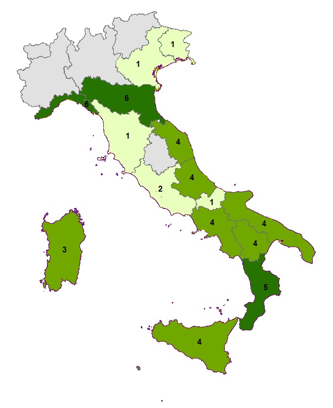
Figure 1: Regional Coastal Planning Activities Fonte
ISPRA processing on data from coastal regions Legenda
1-2 operational programs (p.o.) and regional laws; 3-4 integrated protection or management plans; 5-8 integrated protection and management plans adopted and p.o. Note
The value was obtained by attributing a unit weight to the existence of at least one regional plan, a unit weight to each plan and doubled if the plan is approved/adopted. |
Titolo
Table 1: Regional Coastal Plans Fonte
ISPRA processing on data from coastal regions Legenda
The total Regional Plans is determined considering only the regions that have an approved/adopted plan extended to the whole regional territory |
Titolo
Table 2: Regional Coastal Plans and calculation of the planning activity indicator Fonte
ISPRA processing on data from coastal regions Note
The value was obtained by attributing a unit weight to the existence of at least one regional plan, a unit weight to each floor and doubled if the plan is approved/adopted. |
Table 1 shows that 11 out of 15 coastal regions have regional planning tools extended to the management and protection of the coastal territory and some are preparing a second regional plan, distinguishing more clearly the one intended for the protection and protection of the coasts from that oriented to the integration of coastal management with socio-economic activities.
The Abruzzo Region, in 2002, approves the feasibility study “Integrated management of the coastal area. Organic plan for the risk of vulnerable areas.” Subsequently, in 2005, the "Recognition of the extraordinary maintenance of the five-year period 2005 - 2010 was approved". In 2006 the interventions planned in the “Ricognizione” and those in the study “Integrated management of the coastal area were also financed. Organic plan for the risk of vulnerable areas. In 2020, the “Coastal Defense Plan from erosion, the effects of climate change and pollution” was adopted, which is the update of the plan previously in force. The plan was approved in 2021. Numerous interventions are also envisaged entirely funded under the National Recovery and Resilience Plan (PNRR) within Mission 2, Component 4 – Investment 2.1B for the management of flood risk and for the reduction of hydrogeological risk.
The Basilicata Region, in 2016, reorganized the competences related to the management of the coast and the marine state-owned areas (DGR no. 565 of 24/05/2016). In the same year, 2016, the “Regional Plan for Coast Management Project” was adopted, introduced by LR n.39/2009. In 2020 the Preliminary Document “Regional Plan of the Coasts” is approved, which provides for the articulation of the Plan in two excerpts, one relating to the Ionian coast, and the other to the Tyrrhenian one. On 28/06/2021 was adopted, with DGR n. 529, the first excerpt, relating to the Ionian coast. The General Report refers to objectives, in line with the contents of the ICZM Protocol.
The Calabria Region, which had the Hydrogeological Plan, in which coastal protection measures had been evaluated and programmed, in 2005 entrusted the Basin Authority with the task of drawing up a specific Integrated Coastal Management Plan, which is, in all respects, a Stralcio Plan of the Basin Plan, falling within an integrated planning framework for the enhancement and protection of water and soil resources. The plan was approved in 2006. In 2013, in order to overcome the problems related to the excessive fragmentation of funding and the realization of works with limited effects on a local scale, in collaboration with the Department of Public Works, the provinces and the Civil Engineers OO.MM., the Regional Basin Authority has launched a joint action aimed at identifying the main criticalities existing on the basis of scientific data and the preparation of the Master Plan of the mitigation of the risk of coastal erosion in Calabria. The Master Plan was approved in 2014. The “Recoastal Erosion Crossing Basin Plan” (PSEC) was approved on April 11th, 2016. In 2017, with the Regional Council Resolution no. 355 of 31 July 2017, concerning the “Programme of interventions for soil protection” from POR Calabria ERDF FSE 2014/2020 resources, the general objectives of regional planning in the field of soil protection were defined, planning the mitigation of the risk of coastal erosion and protection of the coasts.
The Campania Region adopted, between 2006 and 2013, plans for the defense of the coasts developed by the Regional Basin Authorities, now merged into the Hydrographic District Authority of the Southern Apennines and which generally cover the entire regional coastal territory. In particular:
- the Authority of the Liri-Garigliano-Volturno Basin adopted the Coastal Erosion Stratele Plan (PSEC) approved in February 2013;
- the Sele River Interregional Basin Authority has Safeguarding Rules approved in 2010;
- the Regional Bacino Authority Right Sele has adopted provisions of Safeguarding, approved in 2013;
- the Regional Left Sele Authority has a Regional Erosion Road Plan approved in 2011;
- the Regional Basin Authority of Sarno, Territope Stratele Plan (PSEC) approved in 2012;
- the North Western Regional Basin Authority, PSEC approved in 2010.
Since 2005 Emilia-Romagna has been “Guidelines for Integrated Coastal Zone Management – GIZC (D.C.R. no. 645/2005) drawn up on the basis of the European Commission Recommendation 2002/413/EC for the implementation of the ICC in Europe. The Guidelines have recently been updated and further developed, with regard to the coastal physical system, risk factors and defense strategies, from the “Integrated Management Strategy for the Defence and Adaptation of the Coast to Climate Change – GIDAC” (December 2022).
The Lazio Region for years has operated as part of the “Integrated Program of Interventions for the Development of the Coast”, has established the Observatory of the coasts and developed experimental plans inspired by the GIZC. The region, in November 2013, established a Cabin of Regia del Mare to “redeem the Coast Plan, a fundamental tool to promote, also from the urban point of view, the recovery of the coast, rehabilitate the degraded parts and renew beach businesses”. In 2015, the Regional Directorate with responsibility for soil protection approved an activity programme for the guidelines of the Integrated Coastal Defence Plan. In 2019, the Public Works Management, Single Station Procurement, Water Resources and Soil Defense approved the “General Program for the defense and reconstruction of the coasts and the framework of priority interventions for 2019-2021”. In 2023, the region approved the results of the research project drawn up by the Department of Engineering of the University "Roma Tre" as part of the Institutional Cooperation Agreement "Analysing to the Plan of the Coast of the Lazio Region".
The Liguria Region, which already operated with the Territorial Plan of Coordinating Coordination of the Coast (PTC), has developed and adopted in 2012 the Marine and Coastal Environment Plan (PTAMC) of the coastal scope 15, including the physiographic units "Gulf of Tigullio", "Baia del Silenzio" and "Riva Trigoso". Subsequently, in 2016 the coastal scope 08 was developed and approved, including the physiographic units of the Centa and Maremola. In 2023, 16, 17 and 18 were added, treated together and also approved. Safeguarding rules apply to all other areas. The Plan, which provides for the division of the coastal territory into 18 areas, proposes objectives of soil protection and enhancement of environmental quality in the coastal area, understood as a resource; while the Territorial Plan of Coordination of the Coast has been qualified as a planning tool aimed at the realization of an integrated management of the coastal strip.
The Marche Region had already adopted an Integrated Management Plan of coastal areas approved in 2005. In 2015 the Variant to the Integrated Management Plan was approved in order to contain the repeated damage to some inhabited centers and the infrastructure deriving from erosive phenomena and at the same time safeguard the environment and the coastal strip. The Plan, drawn up in accordance with the “Guidelines for the preparation of the new Integrated Management Plan of the Coastal Zones” of 2016, was approved in 2019. The plan for general objectives expressly refers to Article 5 of the “Protocol on Integrated Management of the Mediterranean Coastal Zones”.
The Molise Region carries out coastal defense interventions under the MASE Development and Cohesion Plan (former Ambiente Operational Plan - POA - FSC 2014-2020), which reclassifies in a single instrument all the programming of the Development and Cohesion Fund relating to programmed cycles 2000/2006, 2007/2013 and 2014/2020.
The Puglia Region has identified (LR No. 17/2006), as a tool for managing coastal areas, the Coasts Management Plan, adopted in 2009 and approved in 2011. The purpose of the Plan is to implement an organic management of the coastal territory through which the general principles to which, from the regulatory point of view, the administrative action on maritime state property must comply with the application. In 2015, LR n. 17 "...establishes the articulation of coastal planning at two levels: regional and municipal. It reaffirms the centrality of the Regional Coasts Plan as a reference tool for the protection of the coast and the integrated management and use of state-owned areas. The law establishes the obligation to draw up the Coste Municipal Plan (PCC) for coastal municipalities, according to the indications already provided in the Regional Plan. A “Plan excerpt of the Dynamics of the Coast” was being drafted by the Authority of Bacino della Puglia. To date (October 2024) no news can be found online, therefore, it will not be contemplated in the calculation of the indicator.
The Sardinia Region has established for years the Conservatory of Coasts with the aim of safeguarding, protecting and enhancing coastal ecosystems and integrated management of coastal areas of particular landscape and environmental importance. In 2006 he approved the Regional Landscape Plan, in which he identified the regional coastal landscape areas and specific protection measures. In the period 2010-2013, the region conducted an Action Program for the Coast (CAP), which had as its objective the framing of the coastal environment into unitary physical elements and the identification of coastal areas with greater critical geomorphological and environmental criticality, classifying the stretches of coast in retreat connected to erosive processes of sandy liroa and the rocky tracts subject to landslide instability. The region, in the absence of an organic Coste Plan, with the support of a Technical Table Coste (TTC), which involves services and departments competent in the coastal field, considering the CAP and the results of the survey activities carried out a functional tool for regional programming in relation to defense interventions from erosion, risk mitigation and integrated coastal management, has started the implementation of interventions. Finally, in 2013 the Conservatory of Coasts drafted the Guidelines for the integrated management of beaches in which the operational and management methodologies of sandy coasts are illustrated, including themes for the protection of coastal settlements and their cultural heritage, the sharing of policies through the participation of public and private actors in the coastal area. In 2016, with the Resolution of the Regional Council “Urgent guidelines for the management of the coastal strip” indicated to local authorities and the plurality of subjects who work in the coasts to set the necessary management actions according to the already mentioned guidelines.
The Sicily Region has long been equipped with a PAI (2004) also extended to coastal areas, for which the danger and risk from coastal erosion are evaluated, also providing for the relative rules that regulate its use. The Office of the Extraordinary Commissioner for the Hydrogeological Emergency in the Region of Sicily has drawn up the Regional Plan Against Coastal Erosion (PRCEC), inspired by the LLGGs of the National Table for Coastal Erosion (TNEC) approved in 2020. The PRCEC, as described in the Report, “aims to integrate, implement, modernize and energize it, the Straight Plan for the Hydrogeological Assault (P.A.I.)”. The plan is essentially aimed at defending erosion.
The Tuscany Region had since 2001 a GIZC Plan for hydrogeological reorganization, but of which there is no more evidence online on the sites of the region, and which has therefore been excluded from the calculation of the indicator. To date, the region presents an “Operational Document for the recovery and rebalancing of the coastal strip”, approved in 2016. The Document that contains the programming until 2023 related to interventions for the recovery and rebalancing of the coastal strip, taking into account the indications of the Flood Risk Management Plans (PGRA), with particular regard to the areas at risk of marine flooding.
During 2014, through the regional rule, the Veneto Region has led to the regional administration the planning and execution of the restoration and protection of the coasts, until then entrusted to the Consorzio Venezia Nuova. During 2016, the region adopted as "guidelines" for the sizing of defense interventions from coastal erosion the results of the work "Integrated management of the Coastal Zone - Study and monitoring for the definition of coastal defense interventions from erosion in the Veneto region". The study’s cognitive phase provides a useful framework for the planning, management and monitoring of the interventions of the next decade. In the second part, a single intervention strategy is set for the entire region, identifying the most suitable types of intervention with a view to managing the territory on a regional scale and more suitable for an integrated management of the coastal area, in compliance with environmental constraints.
The regions continue to resort, albeit less than in the past as anticipated, to regional operational plans (POR), or loans provided through financial laws and Community funds (FAS/ERDF), to coastal restoration programmes, which provide for interventions located in areas particularly damaged by erosion phenomena and tsunami events.
This variety of responses to the needs of management and defense of the coast is partly due to the lack of a national policy that regulates, with clear guidelines, the fragmentation and frequent overlap of skills among the many bodies responsible for the management and protection of the marine-coastal environment: this situation has led to the use of plans of a different regulatory nature.
To make up for this lack, in 2015, the Ministry of the Environment and Protection of the Territory and the Sea (today MASE) started the establishment of a National Table on Coastal Erosion (TNEC), formalized in April 2016 with a memorandum of understanding with the coastal regions. The main objective of the initiative, in which all the coastal regions and the various national Basin Authorities participated, consisted in the establishment of general guidelines and criteria for the protection of the coasts, taking into account the territorial characteristics and the planning and planning of interventions for the protection and management of coastal areas implemented by all the regions.
For some regions, there is a gradual transition of the planning of individual coastal defence interventions towards the programmes of measures for the defense against coastal flooding purposes within the Flood Risk Management Plan (PGRA). It is also worth mentioning an element of interest, which is outside the contents of the indicator, but which is reported for completeness, consisting in the progressive diffusion of the “Coast Contracts”, along the lines of the Contracts of Rijeka, introduced by art. 68 bis of Legislative Decree no. 152/06.
From Table 2 and Figure 1, although an increase in the index at regional level is evident, there is a greater awareness of having to define guidelines for the sustainable use of coastal areas and the coordination of activities that develop near the shore, also through guidelines for local administrative units.