Elisa Brustia, Pio Di Manna
The indicator is defined as the number of volcanic eruptions that produced significant impacts on human activities during the year.
In 2024, both Etna and Stromboli were active, with the most pronounced peaks occurring between July and August.
The indicator is determined by the number of volcanic eruptions that have occurred in Italian territory and have had notable effects or consequences on the environment and human activities.
To describe volcanic activity, its environmental effects, and its impact on human activities in Italian territory.
VESUVIUS
Directive of the President of the Council of Ministers 16 November 2015: provisions for the update of the emergency planning for the volcanic risk of Vesuvius for the areas subject to fallout of pyroclastic material - Yellow zone.
Directive of 14 February 2014: provisions for updating the emergency planning for the volcanic risk of Vesuvius.
Decree of the Head of Department of 2 February 2015: indications to the Components and operational structures of the National Service for the updating of emergency plans for the purposes of the precautionary evacuation of the population of the red zone of the Vesuvian area.
PHLEGREAN FIELDS
Decree of the President of the Council of Ministers of 24 June 2016: Provisions for updating the emergency planning for the volcanic risk of the Campi Flegrei (Inside the red zone, yellow zone and twinning map).
Decree of the Head of Department of 2 February 2015: indications to the Components and operational structures of the National Service for the updating of emergency plans for the purposes of the precautionary evacuation of the population of the red zone of the Vesuvian area (Indications also valid for the Campi Flegrei).
Campania Region Resolution n.547 of 4 September 2018 (Eviction planning, approval of meeting areas and gates) Annex 1 - List of meeting areas and gates.
ETNA
Municipality of Catania. Municipal Emergency Plan, Review and update: December 2012, (Art. 3 bis, Law no. 100 of 07/03/2012). Annex R: Volcanic Risk.
STROMBOLI
National emergency plan for volcanic events of national importance pursuant to art. 107, paragraph 1, letter f) of Legislative Decree 31 March 1998, n.112 – August 2015.
VOLCANO
National civil protection plan for volcanic risk on the island of Vulcano (Civil Protection Department - EME/0053056) 07/12/2021. Ordinance no. 14 of 29 January 2022.
-
None
None
INGV (National Institute of Geophysics and Volcanology)
http://www. ingv. it/; http://www. protezionecivile. gov. it/
National
2002-2024
The indicator was developed through in-depth bibliographic research of the necessary data. This research was conducted mainly online, using sources from the Istituto Nazionale di Geofisica e Vulcanologia (INGV - https://www.ingv.it) and the Civil Protection website (https://www.protezionecivile.gov.it).
In 2024, volcanic activity on Etna included eruptions that reached notable peaks between July and August.
Routine activity at Stromboli also intensified during the same period, showing higher-than-usual eruptive peaks.
A clear trend cannot be determined. It is worth noting that the years in which volcanic activity caused the greatest damage were 2002—when numerous injuries occurred due both to the eruption itself and to the anomalous wave generated by Stromboli—and 2019, when one person was killed and another injured during an eruption of Stromboli (Table 3).
In 2003, 2006, 2009, 2012, and 2016, no eruptions occurred that significantly interfered with human activities, nor were any damages to people or property reported.
Overall, volcanic activity has remained steady, punctuated by occasional intensity peaks.
| Allegati |
|---|
Titolo
Table 1: Major Volcanic Eruptions (2024) Fonte
ISPRA (based on INGV data) |
Titolo
Table 2: Main Monitoring Networks on Active Italian Volcanoes Fonte
ISPRA based on INGV information |
Titolo
Table 3: Historical Record of Major Volcanic Events That Affected Human Activities Fonte
ISPRA based on INGV data |
Thumbnail
Titolo
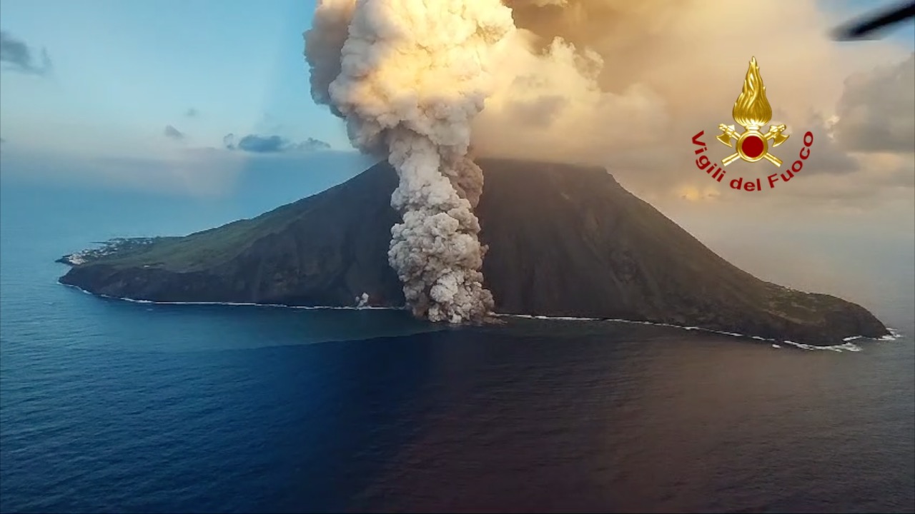
Figure 1: Stromboli 04.07.2024 – Pyroclastic flow along the Sciara del Fuoco Fonte
Fire and Rescue Service |
Thumbnail
Titolo
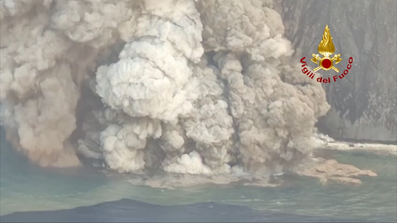
Figure 2: Intensification of Stromboli’s eruptive activity on 04.07.2024 Fonte
Fire and Rescue Service |
ETNA
Strombolian activity at the Voragine crater intensified progressively starting on 24 July, culminating on 4 August in a lava-fountain episode that produced an eruptive plume rising to about 10 km above sea level and dispersing toward the east and southeast.
The fallout of pyroclastic material (lapilli and ash) over Etna’s eastern flank affected numerous settlements, including Fleri, Fornazzo, Zafferana, Milo, Santa Venerina, Giarre, Riposto, Stazzo, Torre Archirafi, San Giovanni La Punta, Viagrande, Aci Sant’Antonio, Aci Catena, Aci Castello, Aci Trezza, and Acireale. INGV-OE staff measured pyroclastic deposits ranging from 3.8 to 4.2 kg/m² between Milo, Santa Venerina, and Zafferana, and recorded lapilli with a maximum axis of about 4 cm in Milo.
Catania Fontanarossa Airport was partially closed.
STROMBOLI
The eruption began on 4 July with the opening of a new effusive vent at around 700 meters above sea level, producing a lava flow down the Sciara del Fuoco. This flow in turn generated pyroclastic currents that reached the coastline and propagated into the sea (Figures 1 and 2).
As activity intensified—especially on 4 July—Civil Protection authorities raised the alert level from orange to red, triggering the pre-alert operational phase. This ensured effective management of public safety but had significant economic and logistical consequences for the island, linked in particular to tourism.