Il 7° Programma di Azione per l'Ambiente Europeo (7° EAP) è stato adottato per il periodo 2014-2020 ed è finalizzato a guidare gli sforzi dell'Unione Europea verso un'Europa più verde e sostenibile. Gli indicatori utilizzati per monitorare il 7° EAP possono riguardare diverse dimensioni ambientali, tra cui la qualità dell'aria, la biodiversità, l'uso sostenibile delle risorse e il cambiamento climatico.
Sono presenti gli indicatori ISPRA che hanno una corrispondenza (non sempre univoca) con gli indicatori “di natura ambientale” del suddetto core set utilizzato da ISPRA per alimentare la pubblicazione “Dati sull’Ambiente”.
In alcuni casi, a un singolo indicatore del core set ISPRA corrisponde uno o più indicatori del core set in questione, o viceversa, più indicatori del core set ISPRA o corrispondono a un singolo indicatore del core set di riferimento.
7° Programma di azione per l’Ambiente Europeo (7° EAP) - Dati sull’ambiente
WASTE RECYCLING RATE EXCLUDING MAJOR MINERAL WASTES
Data aggiornamento scheda:
The indicator is useful for monitoring progress toward a circular economy, allowing for the identification of the quantities of materials reintroduced into the economy following waste treatment. Compared to the total amount of waste sent for recovery and disposal operations, more than three-quarters of the treated waste is recycled, placing Italy among the countries with the highest recycling rates.
CONTAMINATED SITES OF NATIONAL INTEREST
Data aggiornamento scheda:
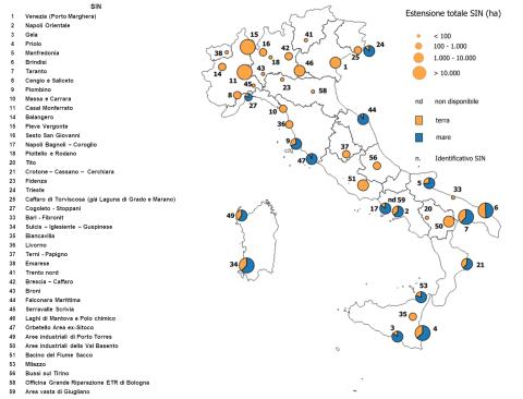
The indicator describes the status of the 42 Contaminated Sites of National Interest (SIN), which together cover 148,594 hectares of land surface (0.49% of the Italian territory) and 77,136 hectares of marine areas. This issue affects all Italian regions, except Molise. As of 30 June 2024, for 65% of the total area of the 36 SINs under consideration, information is available on the progress of the procedures: characterization has been completed for 59% of the soils and 55% of the groundwater, while remediation/safety measures have been approved by ministerial decree for 13% of the soil area and 17% of the groundwater. Procedures have been completed for 17% of the soils and 6% of the groundwater. The information provided by the indicator outlines a representative picture of environmental conditions and societal responses in relation to regulatory and sustainability objectives.
GLACIER MASS BALANCE
Data aggiornamento scheda:
The indicator is calculated for a limited sample of Alpine glaciers and represents the algebraic sum of ice mass gained through snowfall accumulation and mass lost through melting during the ablation period. Glacier mass balance data provide a fundamental measure for assessing the "health status" of glaciers.
Analysis of data from 1995 to 2023 shows that, for the glaciers considered collectively, the cumulative mass balance exhibits significant losses, ranging from nearly 25 meters water equivalent for the Basòdino glacier to over 50 meters water equivalent for the Caresèr glacier, corresponding to an average annual mass loss exceeding one meter water equivalent.
HEATWAVES AND MORTALITY
Data aggiornamento scheda:
This indicator measures the health impact of heatwaves on the elderly population (aged 65 and over) across 27 Italian cities included in the National Heatwave Health Prevention and Warning Plan. The plan is implemented by the National Centre for Disease Prevention and Control (CCM) of the Ministry of Health and coordinated by the Epidemiology Department of the Lazio Regional Health Service (DEP Lazio). The cities are equipped with Heat Health Watch Warning (HHWW) systems to provide forecasts and alerts.
The summer of 2023 (15 May – 15 September) was characterized by temperatures above the seasonal reference average. Despite these elevated temperatures, observed mortality in the elderly population remained generally within expected levels. Monthly impact assessments highlighted increases in mortality rates associated with heatwave episodes during July and August in several monitored urban areas.
This indicator provides critical information for monitoring climate-related health risks and supports adaptation strategies aimed at reducing adverse health effects of heatwaves on vulnerable population groups.
RELATIVE RICHNESS AND ABUNDANCE OF BIRDS IN ITALY
Data aggiornamento scheda:
The indicator measures the abundance and diversity of bird populations in Italy throughout the year, based on bird ringing data. This assessment helps define Italy’s role in the spatial-temporal distribution of European avifauna. Data from 2019-2020 confirm Italy’s crucial importance as a major migration corridor between Europe and Africa and contribute to identifying critical periods for bird species, which is essential for conservation and management purposes.
ECOLOGICAL STATUS OF TRANSITIONAL WATERS
Data aggiornamento scheda:
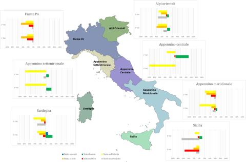
Transitional waters are defined in Legislative Decree 152/2006 as "surface water bodies near a river mouth, partially saline due to their proximity to coastal waters but significantly influenced by freshwater flows." This definition encompasses coastal lagoons and coastal ponds subject to ecological classification. Italian transitional environments are exposed to numerous pressure factors, often leading to degradation of ecological conditions in these fragile ecosystems. The ecological status analysis shows heterogeneous values, both in the number of Water Bodies (WB) and in the distribution across quality classes, with a prevalence of sufficient and poor statuses in all Districts. Comparing the status of the 2nd Water Management Plan (WMP) cycle with that of the 3rd cycle, it is observed that for all hydrographic districts, ecological status remains predominantly sufficient and poor. However, there is an increase in the percentage of water bodies in good status in the Eastern Alps District (from 7% to 11%), Northern Apennines District (from 10% to 20%), Southern Apennines District (from 0% to 6%), and Sardinia District (from 0% to 26%). National analysis of ecological status shows that the number of water bodies in good or high status increased from 9 out of 172 (5%) in the 2nd WMP cycle to 22 out of 146 (15%) in the 3rd cycle.
SOIL DEGRADATION
Data aggiornamento scheda:
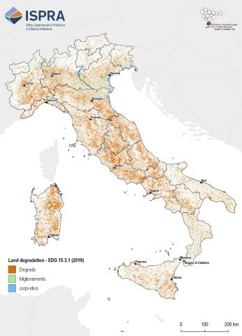
Soil degradation refers to the reduction in the biological productivity of soil resources. This process is often intrinsically linked to biodiversity loss and the impacts of climate change. Assessing soil degradation requires considering multiple interdependent factors, each contributing differently to the phenomenon.
In recent years, Italy has participated in the pilot project on Land Degradation Neutrality (LDN), promoted by the United Nations Convention to Combat Desertification (UNCCD), and in the LDN Target Setting Programme, which supports countries in identifying voluntary LDN targets and defining associated measures to achieve Sustainable Development Goal (SDG) 15.3. This goal is monitored through the "Proportion of degraded land over total land area" (SDG Indicator 15.3.1).
For the assessment of this indicator in Italy, three sub-indicators proposed by UNCCD under the LDN framework have been adopted:
- Land cover change
- Soil productivity index
- Soil organic carbon content
Additionally, further indices and parameters relevant to the Italian context and available at the national level have been considered. The results show that in 2019, the proportion of degraded land in Italy, excluding water bodies, was 17.4%, according to the UNCCD methodology. Furthermore, nearly 56,000 km² (approximately 18.5% of the national territory) experienced increased degradation between 2006 and 2019.
LAND USE
Data aggiornamento scheda:
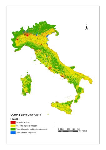
The indicator describes land use (agricultural, urban, industrial or commercial, infrastructure, recreational, natural and semi-natural, water bodies, etc.), reporting the territorial surfaces associated with different classes according to the CORINE Land Cover classification system. Between 2012 and 2018, there was a continued general increase in artificial urban areas, primarily at the expense of agricultural land. In Italy, as in the rest of Europe, cultivated areas show a contraction, linked not only to urbanization processes but also to agricultural land abandonment.
ECOLOGICAL STATUS OF COASTAL MARINE WATERS
Data aggiornamento scheda:
Coastal marine waters are defined as “surface waters situated inside an imaginary line one nautical mile away, at every point, on the outer side from the nearest point of the baseline used to define the territorial sea limit, and potentially extending to the outer boundary of transitional waters.” The legislation (Legislative Decree 152/2006) mandates achieving "good" status (ecological + chemical) for water bodies by the deadlines set by current regulations; failure to meet environmental goals entails remediation measures. Based on the analysis of data reported by Districts in the 3rd Reporting to the European Commission for the six-year period 2016–2021 (3rd WMP), the ecological status of Italian coastal marine waters is heterogeneous. This heterogeneity is expressed in both the number of water bodies identified per district and their ecological classification. The Eastern Alps, Northern Apennines, Central Apennines, Sicily, and Sardinia Districts show a percentage of water bodies in good and high ecological status greater than or equal to 70%. Specifically, in the Sardinia District, more than 40% of water bodies are in high status. Nationally, more than 60% of water bodies (261 out of 394 total) are in good and high ecological status. Comparing data from the 2nd WMP and the 3rd WMP shows that in the 2nd WMP, 27% of water bodies had unknown ecological status (149 out of 561 total), while in the 3rd WMP, only one water body is in unknown ecological status. In general terms, the proportion of water bodies in good and high ecological status increased from 55% in the 2nd WMP to 66% in the 3rd WMP.
WATER EROSION
Data aggiornamento scheda:
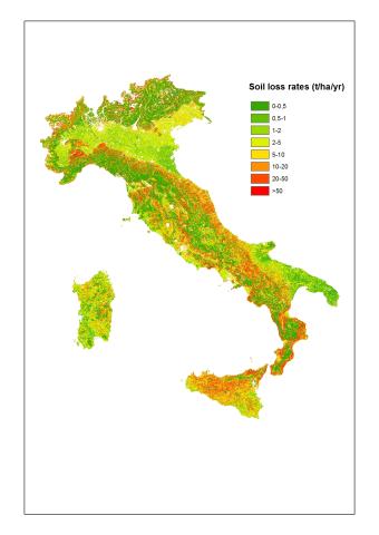
The indicator estimates soil loss due to water erosion, expressed in tonnes per hectare per year.
According to European estimates, Italy loses on average 8.77 tonnes/hectare/year, significantly higher than the European average.
RICHNESS AND RED LIST STATUS OF ANIMAL SPECIES
Data aggiornamento scheda:
The Italian fauna is estimated to include over 58,000 species, with the total number reaching approximately 60,000 taxa when considering subspecies. However, this biodiversity is under threat, as indicated by IUCN assessments and population trends. Among the 672 species of Italian vertebrates (576 terrestrial and 96 marine), 6 are extinct in Italy, and 161 are threatened with extinction (accounting for 28% of the assessed species). Different vertebrate groups show varying percentages of risk: 2% for marine bony fish, 19% for reptiles, 21% for cartilaginous fish, 23% for mammals, 36% for amphibians, and up to 48% for freshwater bony fish (considering the CR+EN+VU IUCN categories). Additionally, terrestrial and marine vertebrate populations are generally declining by 27% and 22%, respectively.
Breeding birds are the only group for which two IUCN assessments have been conducted, seven years apart. Of the 278 species assessed in the latest 2019 evaluation, 5 are extinct, and 67 are threatened (compared to 76 in 2013), representing 26% of the evaluated species. Half of Italy's breeding bird species are not at immediate risk of extinction.
Among invertebrates, 9% of corals, 11% of dragonflies, 21% of saproxylic beetles, 6% of butterflies, and 11% of assessed bees are threatened with extinction. Invertebrates also show negative trends; for example, 16% of dragonfly populations are in decline, five times higher than those increasing.
CHEMICAL STATUS OF TRANSITIONAL WATERS
Data aggiornamento scheda:
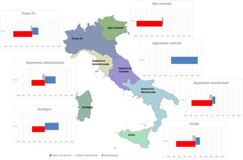
The legislation (Legislative Decree 152/2006) mandates achieving good status of water bodies (chemical + ecological) by the deadlines established by the current legislation. The analysis of chemical status shows heterogeneous values among the districts, with 100% of water bodies in good status only for the Central Apennines and 52% for Sardinia. In all other districts, the percentage of water bodies in good status never exceeds 50% and ranges from 3% in the Eastern Alps to 40% in the Northern Apennines.
A comparison between the status in the 2nd Water Management Plan (WMP) cycle and that in the 3rd cycle shows maintenance of good chemical status for 100% of the water bodies in the Central Apennines, an improvement for those in the Northern Apennines (from 30% to 40%), Sardinia (from 12% to 52%), and Sicily (from 11% to 17%), and a worsening for the water bodies in the Eastern Alps District (from 51% to 3%), Po River (from 65% to 23%), and Southern Apennines (from 18% to 11%).
At the national level, the number of water bodies in good status is 56 out of 172 (33%) in the 2nd WMP cycle, while in the 3rd cycle it is 42 out of 146 (29%).
FIRST CATEGORY MINERAL EXTRACTION SITES (MINES)
Data aggiornamento scheda:
The indicator considers extraction sites for first-category minerals, as classified by current regulations, excluding fluid energy sources and mineral and/or thermal water springs, present in the national territory from 1870 to the present. It serves a dual purpose: identifying potential mineral deposits still exploitable with sustainable techniques and locating potential sources of pollution associated with past extraction methods.
Of the 3,016 sites that have been operational in the past 150 years, only 94 currently hold valid concessions, and 76 sites were active in 2020. 562 abandoned or decommissioned mining sites present a medium to high ecological and health risk. Several museum sites have been integrated into the National Network of Mining Museums and Parks (REMI), coordinated by ISPRA.
CHEMICAL STATUS OF COASTAL MARINE WATERS
Data aggiornamento scheda:
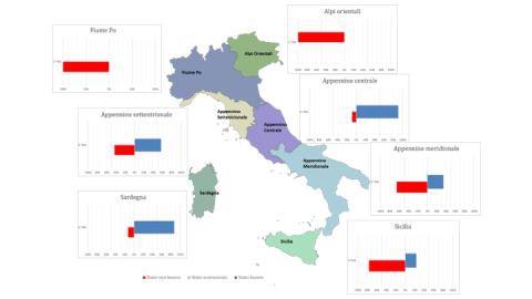
Coastal marine waters are “surface waters located inside an imaginary line, every point of which is one nautical mile seaward from the nearest point of the baseline used to determine the limit of territorial waters, and which may extend up to the outer limit of transitional waters” (Paragraph 1 of Article 74 of Legislative Decree 152/2006). The legislation (Legislative Decree 152/2006) mandates the achievement of a “good” status of water bodies (chemical + ecological) by the dates set by current legislation; failure to achieve environmental objectives results in the implementation of remediation measures. Based on the analysis of data reported by the Districts in the 3rd Reporting to the European Commission for the 2016–2021 six-year period (3rd RBMP), the chemical status of Italian coastal marine waters appears heterogeneous. This heterogeneity is evident both in terms of the number of water bodies identified per district and their classification. The Eastern Alps and Po River Districts have all water bodies in a “not good” chemical status, while in Sicily and the Southern Apennines District, over 60% of the water bodies are in a “not good” status. The Northern Apennines, Central Apennines, and Sardinia Districts, instead, register more than 50%, more than 90%, and more than 80%, respectively, in a “good” chemical status. At the national level, 51% of coastal marine water bodies are in good chemical status. Comparing the 2nd and 3rd RBMPs, in the 2nd RBMP, water bodies with unknown chemical status amounted to 26% (147 out of 561), whereas in the 3rd RBMP, only one water body has an unknown status. Generally, water bodies in good chemical status are comparable between the two RBMPs—52% and 51%, respectively—while water bodies in not good chemical status increased in the 3rd RBMP (49%).
CLIMATE CHANGE ADAPTATION STRATEGIES AND PLANS
Data aggiornamento scheda:
Regional Climate Change Adaptation Strategies and Plans are the primary tools available to regional authorities to address the impacts of climate change and implement actions aimed at reducing territorial vulnerabilities. In Italy, the number of adopted regional strategies and plans remains very limited. Despite the absence of a binding regulatory framework and a national programmatic reference context, there are ongoing initiatives, projects, and climate vulnerability studies that are expected to lead toward the formal adoption of first Adaptation Strategies and subsequently Climate Change Adaptation Plans. The challenge posed by climate change urgently requires the definition and implementation of concrete actions to enhance territorial resilience.