Marco Di Leginio, Fiorenzo Fumanti
The indicator estimates soil loss due to water erosion, expressed in tonnes per hectare per year.
According to European estimates, Italy loses on average 8.77 tonnes/hectare/year, significantly higher than the European average.
Water erosion of soil is an extremely complex and unavoidable natural phenomenon, constituting an integral part of the Earth's surface shaping processes. It depends on climatic conditions, as well as geological, pedological, hydrological, morphological, and vegetational characteristics of the territory, but it can be accelerated by anthropogenic activities, especially those related to agro-silvo-pastoral practices (crop types, tillage and cultivation systems, forest management, grazing), leading to the emergence of serious economic and environmental issues.
In agricultural areas where specific agri-environmental control and mitigation measures are not implemented, erosion—especially in its more intense forms—represents one of the main threats to proper soil functionality. The removal of the uppermost layer of soil, rich in organic matter, significantly reduces its productivity and, in the case of shallow soils, may lead to the irreversible loss of arable land.
Direct measurement of the phenomenon is carried out in equipped experimental fields which, however, are currently scarce and unevenly distributed throughout the national territory. Therefore, in the absence of a national monitoring network, the assessment of annual soil loss is conducted using modelling approaches. As with all models attempting to describe complex natural processes, the final output provides an approximation of the actual situation, the accuracy of which depends not only on the model used but also on the quality of the input data and the weight assigned to the various parameters.
The indicator provides an estimate of soil loss due to water erosion based on cartographic datasets produced at both European and national levels using the Universal Soil Loss Equation (USLE) model.
To assess the risk of soil erosion due to rainfall and surface runoff. This estimate is particularly useful as a decision-support tool for planning soil conservation interventions.
The last three European Environmental Action Programmes (5EAP, 6EAP, and 7EAP) and Agenda 21 set general goals regarding sustainable land use, nature protection, and biodiversity conservation.
COM (2006) 231 and the proposed EU Soil Protection Directive COM (2006) 232—although definitively withdrawn in 2014—identified erosion risk as one of the main threats to European soils.
In Regulation (EC) 1782/2003, establishing common rules for direct support schemes under the Common Agricultural Policy, erosion control is one of the main requirements for maintaining agricultural land in good agronomic and environmental condition.
National-scale assessments of soil loss rates inevitably suffer from the limited accuracy of the data used and produce differing results depending on the relative weight assigned to the parameters considered.
Regional-level assessments, in addition to relying on higher-quality information, have the significant advantage of being testable in the field through verification of their correspondence with actual ground conditions.
Possible data integrations in this important sector lie in the need to use more up-to-date soil databases, better distributed across the territory and capable of ensuring coverage at scales that are certainly valid at the regional and provincial levels. In this regard, a joint project involving ISPRA, the Regions, JRC, and CRA is currently underway, aimed at harmonizing the information available at the regional level (SIAS Project).
ARPAV (Veneto Environmental Protection Agency),
CREA (Council for Agricultural Research and Economics),
ISPRA ,
JRC (Joint Research Centre),
Regional administrations.
National, Regional (14 out of 20 regions)
2014 (SIAS project – 14 regions), 2015
Modelling of climatic, topographic, pedological, and land use data applied over a square grid of 1 km side length.
Model-based estimates, despite the aforementioned limitations, provide sufficiently adequate information for a national-level synthesis. Various areas of the national territory are subject to more or less pronounced soil loss due to water erosion, with significant economic implications in hilly zones hosting high-value crops.
A quantitative definition of the trend is not possible, but the gradual expansion of forested areas at the expense of agricultural land—confirmed by CLC data—suggests a decrease in the phenomenon in mountainous zones. Conversely, the intensification of mechanisation in agricultural hillsides implies an increase in the phenomenon, also linked to the rising erosivity of rainfall observed in recent years, with more intense and closely spaced downpours.
Particular attention should be paid to the impact of forest fires, which render even forest soils highly susceptible to erosion. Initial data on the effectiveness of agri-environmental measures introduced by the new Common Agricultural Policy (CAP) and included in the National Strategic Plan for Rural Development show a significant reduction in erosion processes following their application.
Non definibile
| Allegati |
|---|
Thumbnail
Headline
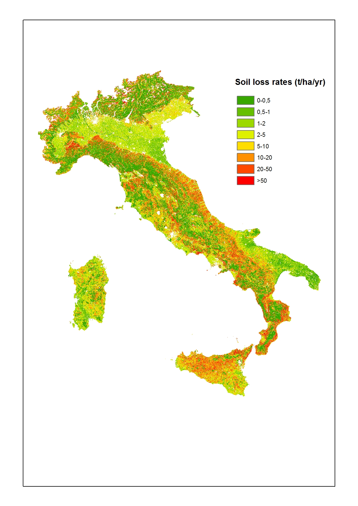
Figura 10.31: Stima della perdita di suolo per erosione idrica espressa in tonnellate/ettaro*anno (2015) Data source
JRC-IES |
Thumbnail
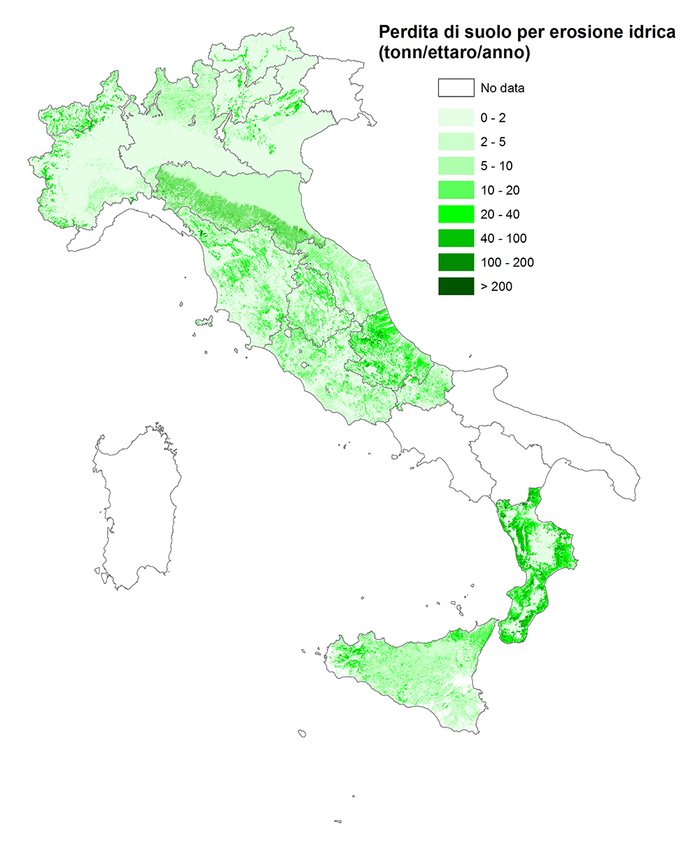
Headline
Figura 10.32: Valutazione della perdita di suolo per erosione idrica in Italia secondo i dati del Progetto SIAS (2014) Data source
ISPRA, ARPAV, Regioni, Province autonome, CREA |
Figure 1 reports the most recent elaboration on soil loss due to water erosion conducted in 2015 by the Joint Research Centre of the European Commission. The methodology used is the Revised Universal Soil Loss Equation (RUSLE, Wischmeier & Smith, 1978), an empirical model tested on standard-size experimental plots, capable of providing quantitative results on actual or potential soil loss.
The result provides an estimate of erosion expressed in tonnes/hectare/year.
The parameters considered in the equation are climatic, pedological, morphological, vegetational, and land use-related:
A = R * K * L * S * C * P,
where:
Compared to the previous edition, also carried out by JRC using the same methodology, the data sources for defining the parameters of the equation were as follows:
The final result, represented on a 100-meter grid, shows that EU Member States report average soil loss values of 2.46 tonnes/hectare/year, corresponding to 970 million tonnes lost annually. Italy reports the highest values, with an average of 8.77 tonnes/hectare/year, slightly above those from national elaborations (see below, SIAS project) ranging from 6.5 to 7 tonnes/hectare/year.
Figure 2 displays a map produced within the SIAS Project, involving all regional technical offices (except Friuli Venezia Giulia, Liguria, Puglia, Umbria, and Lazio). The project’s primary objective is the harmonisation of pedological data, specifically those related to water erosion, through the adoption of a shared data exchange format and final data representation on an INSPIRE-compliant 1x1 km grid.
The algorithm used is the Universal Soil Loss Equation (USLE) and its revised version (RUSLE), which has the significant advantage of being validated by local authorities through comparison with in-field observations. Despite adopting a common format, differences remain due to the varied importance assigned by individual regions to their land management policies and the different robustness of their regional databases.
It should be noted that Campania and Sardinia are not included in the graphic elaboration due to the adoption of erosion estimation models not comparable with the USLE, while the elaborations for Lazio and Umbria were carried out by CREA-RPS in Rome.