Elisa Brustia, Mariapia Congi, Giovanni Finocchiaro, Roberto Pompili
The indicator expresses the number of geosites, geological sites of such importance as to warrant interest in their conservation and protection, which to date have been identified, described and inventoried in the ISPRA Geosites database. As of 30 September 2025, there are approximately 2,100 geosites.
Geosites constitute the fundamental element of geological heritage. These sites, of geological interest, are particularly important for reconstructing the geological history of the area where they are located, making their conservation a matter of interest. They include "geological singularities" (sites rich in fossils, minerals, landscape morphological elements, etc.) that, due to their rarity, scientific value, scenic beauty, and cultural and educational accessibility, can be considered true "geological monuments" to be protected, safeguarded, and enhanced.
Geosites represent the geodiversity of a territory, which is closely linked to biodiversity. The geological characteristics of the substrate influence the diversity of life that develops upon it and are, in turn, influenced by it. Thus, the conservation status of geodiversity affects biodiversity, making its protection essential to maintaining environmental balance.
The indicator reflects the Italian geosites that have been identified, described, and inventoried in ISPRA’s Geosites Database, which is publicly accessible at:
https://sinacloud.isprambiente.it/portal/apps/sites/#/inventario-nazionale-geositi-1
To provide a scientific description of Italian geosites, offering information on their significance for conservation purposes. Additionally, it aims to describe their lithological and environmental characteristics for their promotion and economic enhancement (geotourism) and to foster public awareness of geodiversity through educational initiatives.
There are no binding legal obligations; however, among the main legal references the following are cited:
- Law No. 42/2004 and subsequent amendments, “Code of Cultural Heritage and Landscape”
- Law No. 9/2006, Emilia-Romagna Region, “Rules for the conservation and enhancement of the geodiversity of Emilia-Romagna and related activities”
- Law No. 39/2009, Liguria Region, “Rules for the enhancement of geodiversity, geosites and karst areas in Liguria”
- Law No. 33/2009, Apulia Region, “Protection and enhancement of geological and speleological heritage”
- Law No. 32/2015, Basilicata Region, “Conservation and enhancement of geological heritage”
- Law No. 15/2016, Friuli-Venezia Giulia Region, “Provisions for the protection and enhancement of geodiversity and geological and speleological heritage and karst areas”
- For completeness of information on the subject, the following is also cited:
- Veneto Region: Regional Government Resolution No. 221 of 28 February 2017, “Census and cataloguing of geosites of the Veneto Region. Establishment of the Regional Catalogue of Geosites”
- Regional Law No. 30 of 2015, Tuscany Region, “Rules for the conservation and enhancement of the naturalistic and environmental heritage of the Tuscany Region”
- Regional Law No. 23 of 6 October 2023, “Provisions for the conservation, management and enhancement of geological heritage”
J. Brilha, M. Gray, D. I. Pereira, P. Pereira, 2018. Geodiversity: An integrative review as a contribution to the sustainable management of the whole of nature. Environmental Science and Policy 86 (2018) 19–28
Díaz-Martínez, E., Brilha, J., Brocx, M., Erikstad, L., García-Cortés, A. & Wimbledon, W. A. P., 2016. Global Geosites: an active and partially achieved geoheritage inventory initiative, waiting to regain official recognition. In: Cornée, A., Egoroff, G., de Wever, P., Lalanne, A. & Duranthon, F. (eds.), Actes du congrès international «Les inventories du géopatrimoine», 22-26 September 2015, Toulouse. Mémoire hors-série de la Société géologique de France, vol. 16, p. 103-108.
Gray (2013) - Geodiversity: Valuing and Conserving Abiotic Nature. 2nd Edition. Chichester, U. K.,
John Wiley & Sons. Wimbledon W. A. P. (1996a) – Geosites-a new conservation initiative. Episodes 19(3): 87-88.
Wimbledon W. A. P. (1996b) - National selection, a stop on the way to a European geosite list. Wimbledon W. A. P. & Smith-Meyer S. (eds) (2006) – Geoheritage in Europe and is conservation. ProGEO, 405 p.
http://whc. unesco. org/ World Heritage website
Giovagnoli, M. C. (2023). The Italian Geosite Inventory: Past, Present, and Future. Geoheritage, 15(2), 69.
A working group was established between ISPRA and eighteen Italian regions along with the two autonomous provinces to harmonize inventory criteria across the national territory and to identify classification standards for geosites. In 2021, the group produced a first draft of the Guidelines for Geological Heritage, which also include the criteria for the classification of geosites of international, national, regional, and local interest. Since 2022, these guidelines have been undergoing testing.
ISPRA
ISPRA Geodatabase Geosites (https://sinacloud. isprambiente. it/portal/apps/sites/#/interno-nazionale-geositi-1).
National, Regional
2002-2025 (30.9.25)
The indicator requires simple algebraic and GIS analyses to determine numbers, percentages, and cartographic representations.
The objective of identifying the geosites of greatest scientific interest throughout the national territory, in as uniform a manner as possible, and of describing their condition for the purposes of conservation—although still far from being fully achieved—is ongoing and is attracting increasing attention and participation from local institutions.
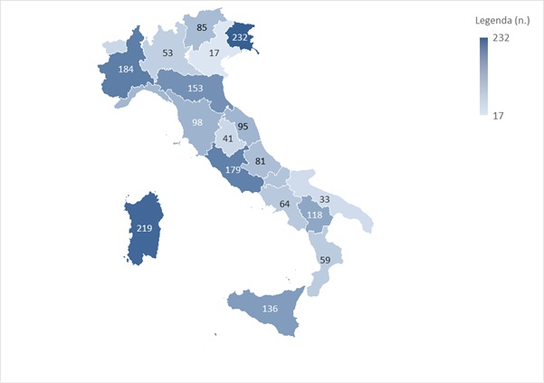
As of 30 September 2025, just over 2,100 geosites have been inventoried, about 70 more geosites than in the previous year, but the number is continuously evolving (Figure 1). This reflects an increase in environmental awareness among citizens, particularly with regard to geodiversity. Thanks to collaboration with the Italian regions, the entire inventory is being revised, progressively updating the geosite records it contains. Over the years, the total number generally tends to decrease in favour of data quality.
The improvements made to the Inventory have made it possible to enrich the content of the surveyed geosites, thanks to more efficient updating activities and more accurate data collection. As a result, the current picture of the Italian geosite “landscape” is more complete and representative, configuring a trend that is considered positive.
| Data |
|---|
Thumbnail
Headline
Figure 1: Number of geosites by region Data source
ISPRA |
Thumbnail
Headline
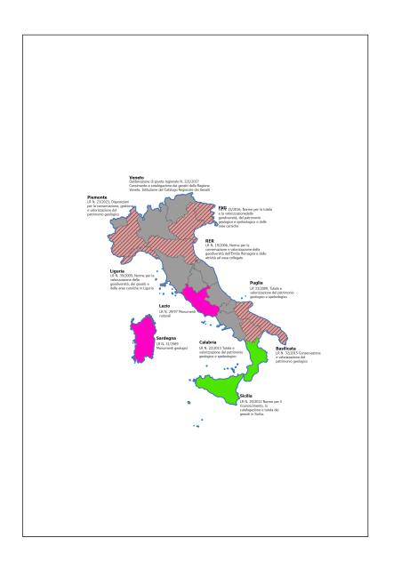
Figure 2: Map of regional legislation for the protection of geological heritage in Italy Data source
ISPRA |
Thumbnail
Headline
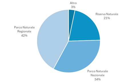
Figure 4: Geosites in protected areas Data source
ISPRA |
Thumbnail
Headline
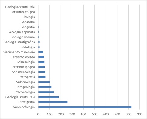
Figure 3: Geosites by scientific interest Data source
ISPRA |
Figure 1 highlights marked differences in regional distribution, which do not necessarily depend on greater richness of geological heritage but are instead linked to the different levels of progress in geosite inventory projects carried out by the regions. In recent years, the unevenness between different areas has gradually decreased, although considerable work still remains to be done, especially in regions where the low number of geosites does not reflect the actual regional geological situation.
Figure 2 shows that current national legislation does not contain specific references to the protection and management of geosites. Legislative instruments that can be used for the protection of geological heritage are instead found in laws and decrees regulating the establishment of parks, reserves and soil protection. The drafting of territorial and/or landscape plans in accordance with Law No. 42/2004, known as the Codice Urbani, has played a fundamental role in encouraging local administrations to take an interest in geological heritage, thereby stimulating the protection and enhancement of recognised geosites and encouraging some regions to enact specific laws in this direction.
However, the absence of a national law is still felt, also in light of regional laws which—except for cases such as Emilia-Romagna and Friuli-Venezia Giulia—sometimes prove to be ineffective.
With regard to “primary scientific interest” (Figure 3), geomorphological geosites clearly prevail within the Inventory. Two main considerations can be made in this regard: first, geomorphological geosites always possess landscape qualities that make them particularly visible and easily recognisable; second, the recognition of geosites provided for by the Codice Urbani (Law No. 42/2004) and their inclusion in local administrations’ spatial planning has contributed to consolidating a view of geosites oriented primarily towards their landscape value.
Finally, geosite status does not in itself confer an obligation of protection on the feature concerned. Geosites that can be considered already “protected” are those located within protected areas (Figure 4).