Giovanni Braca, Stefano Mariani, Robertino Tropeano
The indicator Internal flow provides the annual estimate, expressed in mm, of the quantity of renewable water resource that is naturally produced in a given area as a result of rainfall. The indicator is calculated for each year from 1951 to 2025.
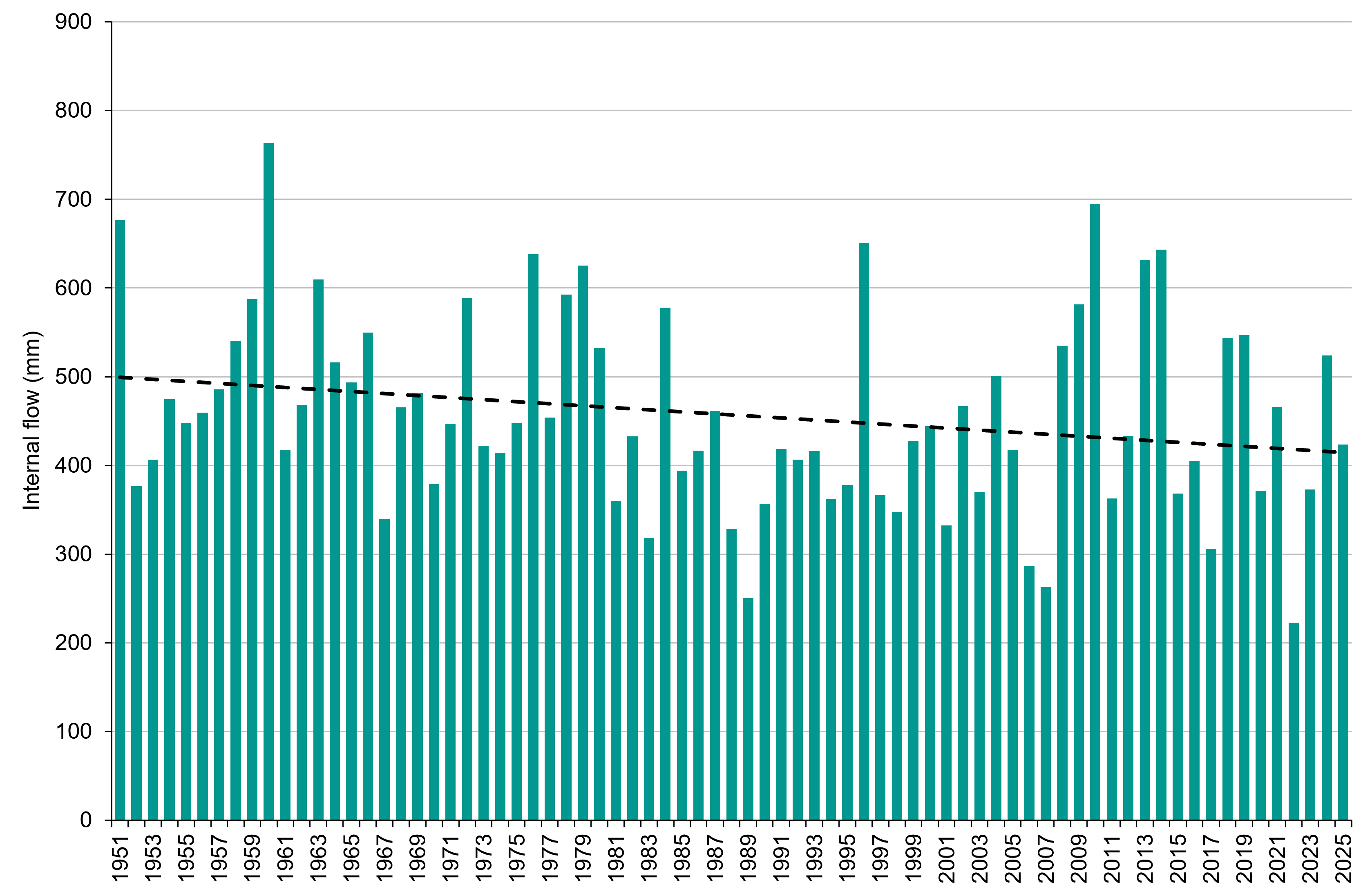
In 2025 the value of the indicator at national level is 423.8 mm, corresponding to 128 billion cubic metres. The average value of the indicator compared to the national territory of the last thirty climatological years 1991–2020 is 442.6 mm, corresponding to 133.7 billion cubic meters, while the long-term average 1951–2025 (so-called LTAA‒ Long-Term Annual Average ) is 457.2 mm, corresponding to 138.1 billion cubic meters.
2025 was characterized by a negative anomaly of the renewable water resource both compared to the long-term average (–7.4%) and compared to the last thirty climatological years (–4.3%). The gap increases if the data is compared with the value of the indicator estimated in 2024, equal to 524.2 mm (–19.2%). At a national level, the availability of renewable water resources continues to show a statistically significant negative trend from 1951 to today.
The indicator constitutes, according to the OECD/Eurostat definition, the total annual volume of surface and underground runoff generated, under natural conditions in a given territory, exclusively by precipitation. It can also be expressed as the difference between annual meteoric influx and real annual evapotranspiration. The hydrological variables, on the basis of which the indicator is calculated, by their nature can be influenced by climate change so that the same indicator can in turn be subject to climate change.
The indicator is required by OECD/Eurostat in Joint Questionnaire on Inland Waters for the definition of statistics on water resources. It also contributes to the calculation of indicator 6.4.2 of the Sustainable Development Goals (SDGS) called " Level of water stress: freshwater withdrawal as a proportion of available freshwater resources ” ( https://www. unwater. org/our-work/sdg-6-integrated-monitoring-initiative/indicator-642-level-water-stress-freshwater /) and the indicator Water Exploitation Index plus (WEI+; see the indicator of the same name present in the Environmental Theme "Water Resources and Budget" of the Environmental Indicators Database) adopted by the European Commission within the framework of the Water Framework Directive 2000/60/EC to evaluate the significance of the pressure exerted by withdrawals of water resources on water bodies.
Provide an assessment of the quantity of renewable water resource that is naturally produced in a given territory annually and that is available for the needs of ecosystems and for different uses (civil, agricultural, industrial, etc.).
- Legislative Decree no. 152/2006, containing "Regulations on environmental matters" (Official Journal General Series n. 88 of 14-04-2006 - Ordinary Supplement n. 96), which implements the Water Framework Directive 2000/60/EC.
- D. L. N. 39/2023, containing "Urgent provisions to combat water scarcity and for the strengthening and adaptation of water infrastructure" (Official Journal General Series no. 88 of 04-14-2023), converted with amendments by Law no. 68/2023 (Official Journal General Series no. 136 of 13-06-2023), in which the establishment of permanent district observatories on water uses at the district basin authorities was established by a primary regulation.
- European Water Resilience Strategy, adopted by the European Commission on 4 June 2025.
- Amaranto, A., Mancusi, L., Viterbo, F., Bonanno, R., Braca, G., and Garofalo, E. 2025: Unraveling the uncertainties in the climate-water-energy interplay: A distributed analysis of the Italian territory. Renewable Energy, 246, 122857, DOI: 10.1016/j. renene.2025.122857.
- Braca, G., Mariani, S., Lastoria, B., Piva, F., Archi, F., Botto, A., Casaioli, M., Forte, T., Marchetti, G., Peruzzi, C., Tropeano, R., Vendetti, C., and Bussettini, M., 2023: National hydrological balance: focus on drought and natural availability of renewable water resources. Update to 2022. Higher Institute for Environmental Protection and Research. Reports no. 388/2023, Rome. Available online at: https://www. isprambiente. gov. it/it/pubblicazioni/rapporti/bilancio-idrologico-nazionale-focus-su-siccita-e-disponibilita-naturale-della-risorsa-idrica-rinnovabile-formazione-al-2022.
- Braca, G., Bussettini, M., Lastoria, B., Mariani, S., and Piva, F., 2021: The Gis BAsed Hydrological Balance at National Scale on Regular Grid – BIGBANG: methodology and estimates. Report on the natural availability of water resources. Higher Institute for Environmental Protection and Research, Reports 339/21, Rome. Available online at: https://www. isprambiente. gov. it/it/pubblicazioni/rapporti/il-bilancio-idrologico-gis-based-a-scala-nazionale-su-griglia-regolare-bigbang .
- FAO, ISPRA & Istat, 2023: A disaggregation of indicator 6.4.2 “Level of water stress: freshwater withdrawal as a proportion of available freshwater resources” at river basin district level in Italy. SDG 6.4 Monitoring Sustainable Use of Water Resources Papers. Rome, FAO. Available online at: https://doi. org/10.4060/cc5037en .
- Mariani, S., Braca, G., Lastoria, B., Tropeano, R., Casaioli, M., Piva, F., Bussettini, M., 2024: “The hydrological balance, the availability of water resources and the water balance”, in Drought, scarcity and water crises, Emanuele Romano, Ivan Portoghese (ed.), Habitat signa 1, 29-46. Rome: Cnr Editions. Available online at: https://www. cnr. it/sites/default/files/public/media/attivita/editoria/SiccitaInterattiva_ver2. pdf .
- OECD/Eurostat, 2021, Data Collection Manual for the OECD/Eurostat Joint Questionnaire on Inland Waters and Eurostat Regional Water Questionnaire Concepts, definitions, current practices, evaluations and recommendations, Version 4.1.
- SNPA, 2026: The climate in Italy in 2025, forthcoming .
- SNPA, 2023: The climate in Italy in 2022. SNPA Report n. 36/2023. Available online at: https://www. snpambiente. it/2023/07/20/il-clima-in-italia-nel-2022/.
- SNPA, 2021: Report on climate change impact indicators – 2021 Edition. SNPA Report n. 21/2021. Available online at: https://www. snpambiente. it/2021/06/30/rarancio-sugli-indicatori-di-impact-dei-cambiamenti-climatici-editore-2021/.
The indicator is constructed on a monthly scale on the basis of estimates made with the national hydrological balance model BIGBANG, version 10.0, of ISPRA, on the basis of official data produced at national and local level, and subsequently aggregated to the annual scale. This leads to the loss of information on the intra-annual distribution of water resources. Furthermore, previously published estimates, referring to previous versions of the BIGBANG model, may present slight deviations compared to the estimates of the latest available version as some data or schematizations underlying the model may have been improved. Correct comparisons between the indicator values must therefore be made using the same version of the BIGBANG model.
The indicator could be improved by adopting a more robust scheme in the BIGBANG balance model for the evaluation of potential evapotranspiration, but which however requires much more basic data, which is currently not available for the entire Italian territory and for the entire period 1951–2025.
ISPRA (Higher Institute for Environmental Protection and Research)
JRC (Joint Research Centre)
Regional hydro-meteorological services and those of the autonomous provinces
The precipitation and temperature data used are mainly those collected and published by the regional and provincial structures to which, based on art. 92 of Legislative Decree no. 112 of 31 March 1998, the functions and tasks of the peripheral offices of the National Hydrographic and Mareographic Service (SIMN, now merged into ISPRA) of the Department for National Technical Services were transferred. The precipitation data are collected directly from the regional structures and the autonomous provinces, while for the temperature the maps produced within the ISPRA SCIA system are used ( http://www. scia. isprambiente. it ). The precipitation and temperature data aggregated to the monthly scale on the BIGBANG regular grid of 1 km resolution, which covers the entire national territory, are available on the ISPRA Groupware portal ( https://groupware. sinanet. isprambiente. it/bigbang-data/library/bigbang100). Data relating to the hydraulic characteristics of soils are accessible (subject to registration) on the JRC/ESDAC portal ( http://esdac. jrc. ec. europa. eu/content/lucas-2009-topsoil-data ). For the permeability data of the hydrogeological complexes, a new permeability map produced by ISPRA was used.
National, regional, hydrographic districts
1951–2025
The estimate of the indicator from 1951 to 2025 is carried out using the national hydrological balance model on a monthly scale developed by ISPRA, called BIGBANG-Gis BASed Hydrological Balance at National scale on a regular grid, version 10.0, which evaluates the indicator as the difference between the liquid inflows, derived from the spatial interpolation of precise precipitation data recorded by the in situ networks, and the real evapotranspiration, obtained from the balance soil hydrology using the Thornthwaite and Mather method based on temperature data.
Among the geospatial layers used in the calculation of the hydrological balance, it is important for the evaluation of the Internal flow the permeability of hydrogeological complexes.
The indicator is calculated starting from the monthly assessment on a regular grid of 1 km resolution which covers the entire national territory and aggregated to the annual scale.
2025 marks a decrease in the availability of water resources on a national scale of 4.3% compared to the average of the thirty-year climatological period 1991–2020, estimated at 133.7 billion cubic meters, and of 7.3% compared to the long-term average 1951–2025, estimated at 138.1 billion cubic meters. The comparison with the 2024 figure (estimated at 158.3 billion cubic meters) highlights an even more marked decline for 2025, with a drop of 19.2%.
This lower availability of water resources is attributable to the high evapotranspiration recorded on a national scale as a result of the high temperatures that occurred in 2025. The share of evapotranspiration has in fact reached 55.8% of precipitation, a value higher than the long-term annual average, which stands at around 52%, thus reducing the overall availability of water resources.
The negative anomaly recorded in 2025 compared to the long-term average value and the annual average of the thirty-year period 1991–2020 confirms the trend towards reduction in national water availability observed from 1951 to today. This decreasing trend of the time series is statistically significant based on the Mann-Kendall test (with a significance level of 5%).
The indicator takes into account the effect of the temporal variability of soil waterproofing. The trend detected is, however, essentially linked to the variables of precipitation and temperature. In particular, it can be traced back to the increasing trend in average temperature due to climate change: this phenomenon increases the amount of precipitation that evapotranspires, consequently reducing the fraction that feeds the soil and subsoil.
On this front, future scenarios outline for Italy a general contraction in the volume of annual precipitation and an increase in temperatures, a dynamic which should be reflected in an overall reduction in the natural availability of renewable water resources (i. e. The volume of Internal flow).
| Allegati |
|---|
Thumbnail
Titolo
Figure 1: Internal Flow in the period 1951-2025 Fonte
ISPRA processing on data from regional hydro-meteorological offices and autonomous provinces and historical data from the SIMN suppressed |
Thumbnail
Titolo
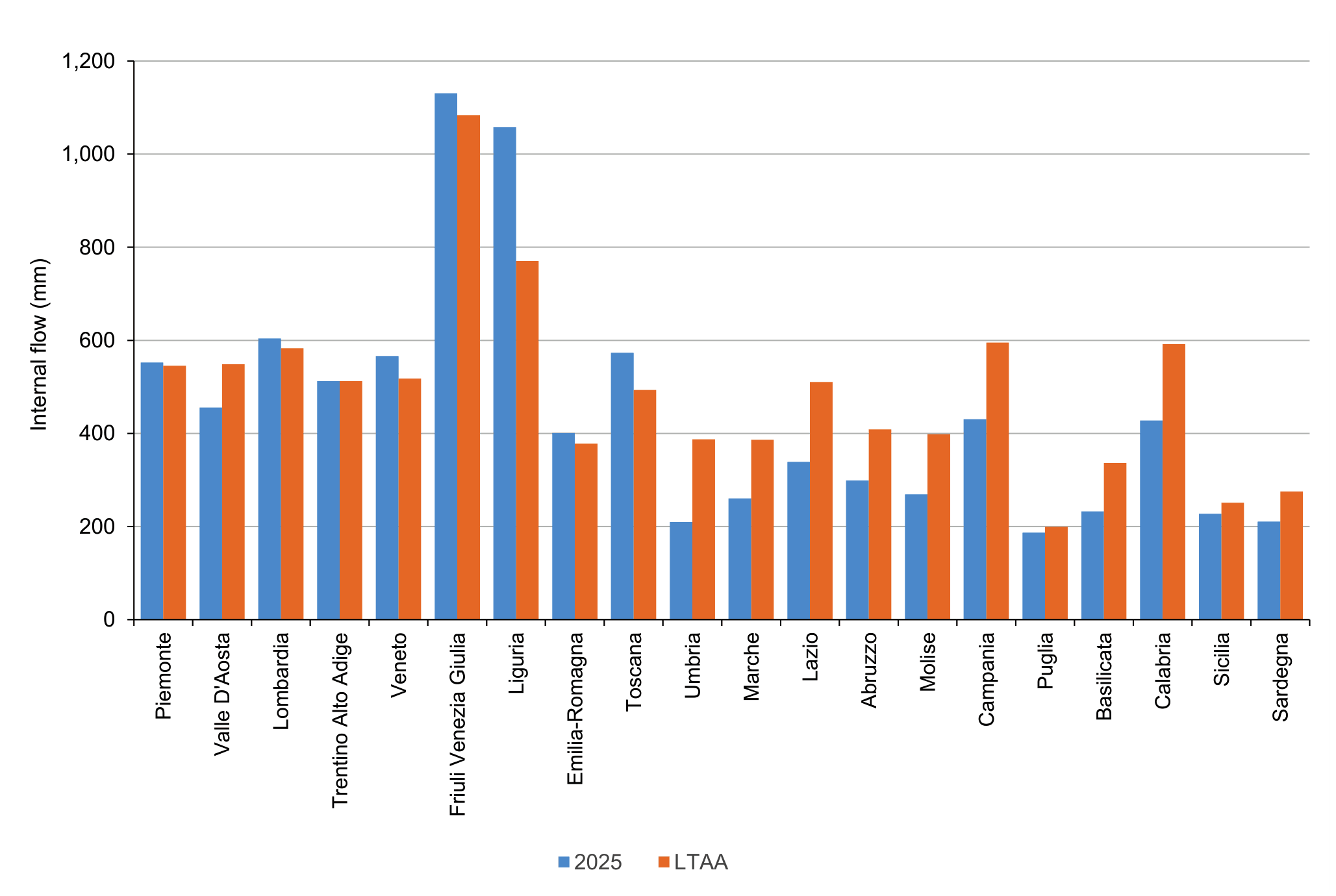
Figure 2: Internal flow at regional level: estimates 2025 vs. long-term annual averages 1951‒2025 (LTAA) Fonte
ISPRA processing on data from regional hydro-meteorological offices and autonomous provinces and historical data from the SIMN suppressed |
Thumbnail
Titolo
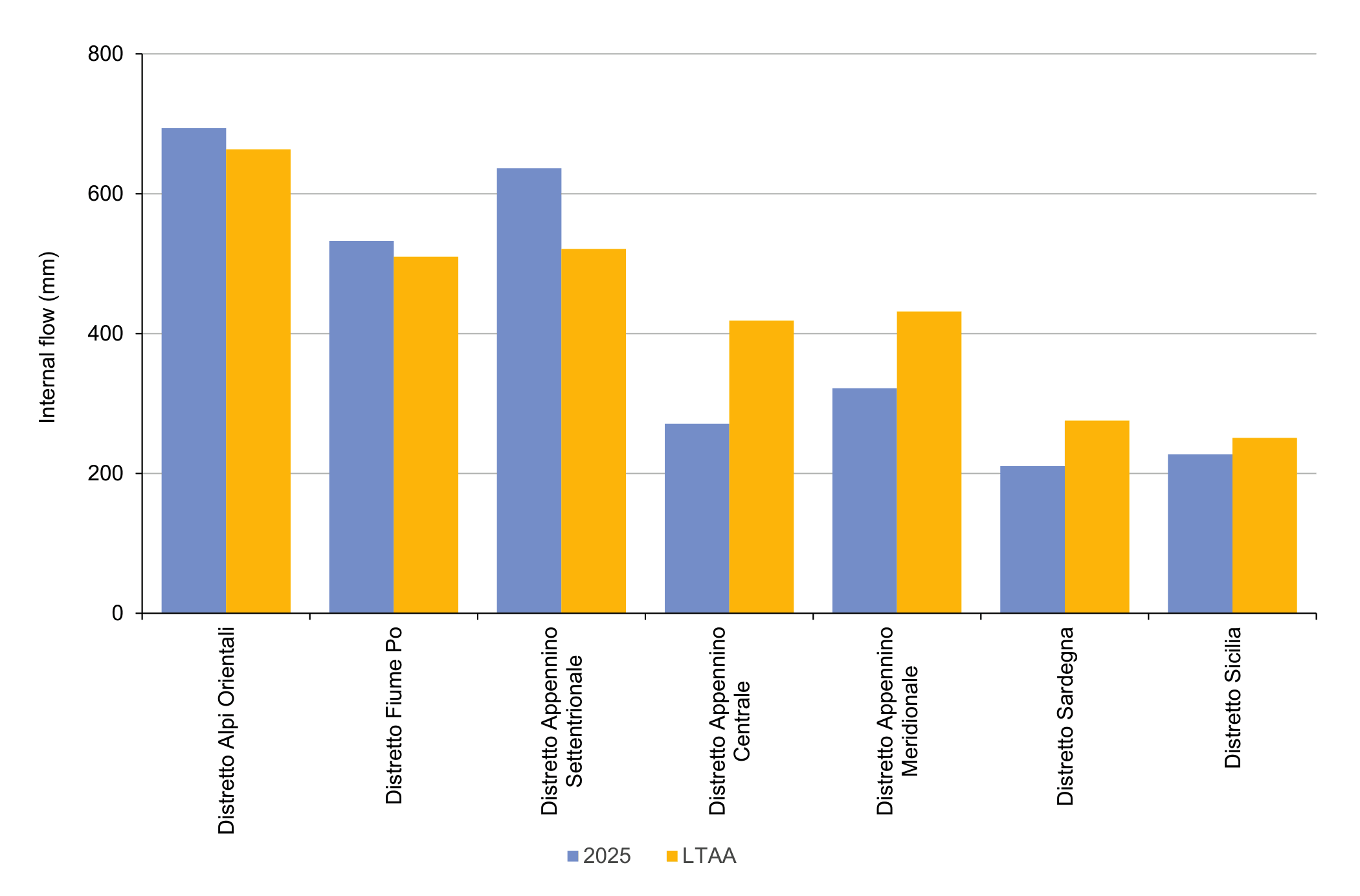
Figure 3: Internal flow at river district level: estimates 2025 vs. long-term annual averages 1951‒2025 (LTAA) Fonte
ISPRA processing on data from regional hydro-meteorological offices and autonomous provinces and historical data from the SIMN suppressed |
The annual estimates of the national hydrological balance model BIGBANG highlight, for 2025, a marked territorial polarization of water resource availability anomalies compared to the long-term annual average values 1951–2025 (LTAA), outlining a clear difference between Northern Italy and the rest of the country.
In the Centre-South, a significant contraction in the annual availability of water resources was observed in 2025, with the most pronounced deficits recorded in Umbria (–45.9%), Lazio (–33.6%) and Marche (–32.6%). In the remaining regions of Central and Southern Italy, the reductions were between –32.4% and –26.8%, with the exception of Puglia, where the deficit was more limited (–6.1%). The island regions also experienced water resource deficit conditions in 2025, albeit with different intensities: Sardinia recorded a decrease of –23.6%, while the contraction in Sicily stood at –9.4% (Figure 2).
Differently, for the North of the country the estimates are generally within values close to or slightly higher than the norm, with positive anomalies in the availability of water resources ranging between +0.1% and +9.3%. The exceptions are Liguria, which has the highest surplus at national level (+37.3%), and Tuscany (+16.3%). In this context, the Aosta Valley represents the only negative anomaly in the northern area, with an availability 17% lower than the corresponding long-term annual average value.
At the district level (Figure 3), the greatest water resource deficit compared to the LTAA affected the Central Apennines Hydrographic District (–35.3%), with an estimated availability in 2025 of 270.9 mm, corresponding to 11.5 billion cubic metres, compared to a long-term average of 418.4 mm, corresponding to 17.7 billion cubic metres. Followed, in terms of reduction of water resources compared to the relative long-term annual averages, are the Southern Apennines Hydrographic District (–25.3%), the Sardinia Hydrographic District (–23.6%) and the Sicily Hydrographic District (with a more contained decrease of –9.4%).
As regards Northern Italy, the BIGBANG model highlights an increase in the annual availability of water resources for 2025 compared to the LTAA in all hydrographic districts: +4.5% in the Po River District, +4.6% in the Eastern Alps District and +22.2% in the Northern Apennines District.
Overall, the picture outlined confirms the strong territorial lack of homogeneity that characterized the availability of water resources in Italy in 2025. While the North benefited from generally favorable conditions and an availability higher or close to the average values, the Centre-South and the major islands continued to suffer from drought conditions, although less severe than those observed in previous years, and high temperatures (see the indicators "Hydrological drought" and "Standardized hydrological-climatic balance" present in the environmental theme “Water resources and budget” of the environmental indicators database). This has strongly influenced the availability of water resources and, consequently, the ability to satisfy the demand for water for anthropic uses and for the maintenance of ecosystem balances.
Therefore, during 2025, the territories of the hydrographic districts of Central-Southern Italy and the major islands continued to be characterized by critical issues related to water severity, from medium to high ( https://www. isprambiente. gov. it/pre_meteo/idro/SeverIdrica. html/). The permanent Observatories for water uses of the hydrographic districts of the Central Apennines, the Southern Apennines, Sardinia and Sicily (bodies of the respective District Basin Authorities, pursuant to Legislative Decree no. 39/2023) have managed these critical issues, adopting appropriate measures and actions of governance based on the level of water severity encountered. In some cases (Sicily, areas of Basilicata served by the Basento-Camastra water scheme, and some Calabrian territories in the provinces of Reggio Calabria, Crotone and Cosenza), the state of emergency due to a serious water deficit has been extended by the Council of Ministers compared to the 2024 resolutions.