Panel 1
Devis Canesso, Marco Cordella, Franco Crosato
A continuous monitoring over time of changes in the delay in the propagation of the astronomical tide allows to highlight the hydrodynamic and therefore morphological changes inside the Lagoon of Venice, which owes its survival to the maintenance of delicate environmental balances. The tidal propagation delays within the lagoon are calculated with respect to the Gulf of Venice, belonging to the same area from a geological point of view, but exempt from the anthropic intervention that distinguishes the lagoon environment considered. Tidal propagation delays are greater the greater the distance of the observation point from the port mouth from which it is fed. The tidal wave takes about 35/40 minutes to enter the lagoon through the narrowing of the three port mouths, while it takes about three hours to reach the most inland and remote areas.
The astronomical tidal excursion is that oscillating movement of open water resulting from the Earth’s rotation motion around its axis and the gravitational pull forces of the Earth-Sun-Luna system. It manifests itself with variable entities in the different seas and oceans and in the Adriatic Sea has the greatest amplitude of the entire Mediterranean basin. The tidal wave, going up the Adriatic in an anti-clockwise direction, enters the lagoon through the three mouths of port (Lido, Malamocco, Chioggia) and propagates following the winding and variable bottom conformation of the canals, which are able to slow down its advance and to dampen the amplitude. This indicator measures the annual changes in the average tidal propagation delays at different sites within the Venice Lagoon. The indicator is calculated from the tidal data collected at the stations of the Mareographical Network of the Venice Lagoon and the coastal arc Nord Adriatico (RMLV), whose structure, organization and functionality is described on the website www.venezia.isprambiente.it.
Through the monitoring of long-term variations on the tidal propagation characteristics within the Venice Lagoon, the indicator provides information on the morphological evolution of the lagoon basin and on the possible variations in the hydraulic arrangements of the lagoon, using as a measuring parameter the delay in propagating the tidal wave compared to the open sea.
The indicator shall meet the knowledge requirements set out in Annex II to Directive 2000/60/EC on coastal waters and transitional waters.
Panel 2
- Comune di Venezia-CPSM, ISPRA, CNR-ISMAR, Previsioni delle altezze di marea per il bacino San Marco e delle velocità di corrente per il Canal Porto di Lido - Laguna di Venezia. Valori astronomici. 2024, Comune di Venezia-CPSM, ISPRA, CNR-ISMAR
- Lionello, P., Barriopedro, D., Ferrarin, C., Nicholls, R. J., Orlić, M., Raicich, F., Reale, M., Umgiesser, G., Vousdoukas, M., and Zanchettin, D.: Extreme floods of Venice: characteristics, dynamics, past and future evolution (review article), Nat. Hazards Earth Syst. Sci., 21, 2705–2731, https://doi.org/10.5194/nhess-21-2705-2021, 2021.
- Matticchio B., Carniello L., Canesso D., Ziggiotto E., Cordella M. "Recenti variazioni della propagazione della marea in Laguna di Venezia: effetti indotti dalle opere fisse alle bocche di porto" in D'Alpaos L. (ed.) "La Laguna di Venezia e le nuove opere alle bocche", Istituto Veneto di Lettere Scienze e Arti, 2017, Venezia.
- Ferrarin C., Tomasin A., Bajo M., Petrizzo A., Umgiesser G., "Tidal changes in a heavily modified coastland wetland", Continental Shelf Review 101 (2015) 22-23.
- Cordella M., Zampato L., Pastore F., Tomasin A., Canestrelli P., "Le tavole annuali di marea per Venezia", Istituto Veneto LL. SS. AA. Atti 169 (2010-2011).
- D’Alpaos L. (2010) “L’evoluzione morfologica della Laguna di Venezia attraverso la lettura di alcune mappe storiche e delle sue carte idrografiche”, Comune di Venezia, Istituzione Centro Previsioni e Segnalazioni Maree.
- Ferla M., Cordella M., Michielli L., Rusconi A., "Long-term variations on sea level and tidal regime in the lagoon of Venice", Estuarine, Coastal and Shelf Science 75 (2007) 214-222.
- Sposito A. e Vultaggio M., (1988), "Analisi armonica e previsione della marea", Giannini Editore.
- IOC (1985), "Manual on sea level measurement and interpretation", UNESCO.
- Goldmann A. et al. (1975), Characteristic of the tidal wave in the lagoon of Venice, Venice Scientific Center.
- Polli S. (1960), “La propagazione delle maree nell’Adriatico”, Atti del IX convegno dell’Associazione Geofisica Italiana.
- Polli S. (1952), "Propagazione della marea nella laguna di Venezia", Annali di Geofisica, vol. n. 2. pp. 273-292.
- Magistrato alle Acque di Venezia - Ufficio Idrografico, Annali Idrologici.
- www.venezia.isprambiente.it
Data quality assessment
Centro Previsioni e Segnalazioni Maree - Comune di Venezia
www.venezia.isprambiente.it
www.comune.venezia.it/maree
The Lagoon of Venice
1989-2023
Indicator assessment
Starting from the historical series of tidal data observed in various stations of the lagoon, the calculation of the components of the astronomical tide is carried out for each year and for each year by breaking down into harmonics. For each component you get a delay and a width. The delay is referred to in conjunction with the seven main harmonic components needed to describe the tide in Upper Adriatic, weighing the delay of the single component for its height. The total delay of the single station is finally calculated using as a reference the station of Acqua Alta Platform, located 8 nautical miles off the Venetian coast, considered representative of the North Adriatic basin. With the entry into operation of the mobile barriers of the Mo.S.E. at the three mouths of the port of Lido, Malamocco and Chioggia, which took place for the first time on October 3, 2020, the data recorded by the stations inside the lagoon undergo further processing. Since 2020 in fact, since the barriers exclude the basin from the natural tidal oscillation to protect Venice and its lagoon from the most severe high waters, in conditions of the regulated lagoon the measured data are purified of the closing periods of the mobile shutters with the addition of an additional interval of 6 hours after the reopening, estimated time for the rebalancing of the lagoon hydraulic arrangements.
The Venice Lagoon is historically an environment by its nature in unstable balance, being exposed both to the risk of burial, due to the contribution of river sediments during floods, and to the risk of transformation into a sea arm, losing the specificity of transitional environment. To avoid the risk of progressive burial, the Serenissima Republic of Venice in the past centuries brought to a successful hydraulic engineering interventions, which determined the diversion of the major rivers that originally flowed inside or in any case near the port mouths (Piave, Sile, Brenta, Adige, Po). The other danger, coming from the sea, was faced by reinforcing part of the sandy coasts that separate the Lagoon of Venice from the Adriatic Sea (the so-called "walls" of the Lido and Pellestrina). During the nineteenth century the port mouths were protected by long dams forane in order to ensure navigability and to prevent the formation of coastal bars of obstacle to navigation, building the so-called “armings” at the mouths. During the twentieth century the large artificial canals were excavated to favor the portualità (the Vittorio Emanuele III and the Malamocco-Marghera) and finally after 2000 begin the work on the port mouths for fixed works and the housing on the backdrop of the movable barriers against floods from high tide (the so-called "Mo.S.E."). Having made this general premise on the historical events that have affected the Venetian Lagoon, it is necessary to define a standard reference condition to which it is possible to be traced back to make comparisons over time. This condition is identified in the tide recorded at the Acqua Alta Water Platform station, located 8 nautical miles off the coast of Venice. This point of observation has the advantage of sharing the general characteristics of the basin of the North Adriatic and of being at the same time exempt from the effects of interventions in the lagoon and the works to the port mouths. It is also not affected by the presence of the coast or piers, with the consequent effects related to the wind and wave setup during the most intense weather events. The tide enters the lagoon through the three mouths of the port of Lido, Malamocco and Chioggia, propagating through the major navigable canals that depart from them and the vast system of meandering natural channels, interacting with the shallow waters, velvesting and barenes, morphological structures typical of a complex lagoon system. The longer the length of the tidal wave path, the greater the effects on the amplitude and phase of the wave itself. In the case of artificial channels, from the rectified course, the inertial effects prevail over dissipative ones and damping are minimal or absent, while the opposite takes place on the slums and along the small channels that ply the areas of velma or barena, where the propagation of the tidal wave is hindered by the friction effects on the bottom. To account for this complexity, the monitoring sites that have been chosen in the indicator are representative of different conditions, some more natural than other more man-made. It was also tried to give a homogeneous cover to the entire lagoon basin, monitoring stations located both just inside the port mouths, and in locations more inland to the lagoon, up to the contermine lagoon (Figure 1). Tide propagation delays within the lagoon increase from 2003/2004, years of start of construction of movable barriers to port mouths for high-water protection. Net of a small inter-annual variability, the indicator shows substantial stability throughout the lagoon from 2014/2015.
In the evaluation of the trend, the negatively affecting increases in tidal propagation delays recorded since 2003-2004, a symptom of an unstable hydraulic balance. In addition, as described in the comments, the extent of such variations is not homogeneous in the lagoon. The changes to propagation delays have a significant impact on the structure of tidal currents, erosive processes and the loss of lagoon sediment, elements that are at the origin of an increase in average depth, with negative consequences also on the aquatic flora that, on the contrary, tends to naturally reduce sediment erosion. These phenomena lead to aggravating the transformation of the lagoon from a transitional environment to the arm of the sea, with negative consequences also on the habitats that characterize it, increasing pressure and impacts on the flora and fauna present. The strong variations in tidal propagation delays of the years 2003/2004 until 2010 testify to a violent change in the hydraulic balances inside the lagoon. In the most recent past, net of slight variations for local set-ups, also in 2023 the trend in place since 2010 is confirmed, which is almost stable throughout the lagoon.
Data
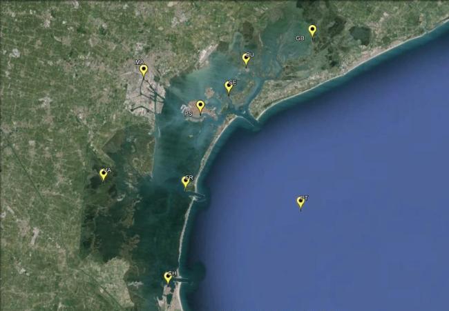
Figure 1: Map of the tidal stations
ISPRA elaboration on data Municipality of Venice - Forecast Center and Tides and Reports and ISPRA
Station: PT: Piattaforma Acqua Alta; BU: Burano; CH: Chioggia Vigo; FR: Faro Rocchetta; GB: Grassabò; MA: Marghera; Se: Sant'Erasmo; PS: Punta Salute; VA: Valle Averto
The substantial stability of the propagation delays of the astronomical tide wave since the beginning of the 90s is interrupted in all the stations of the lagoon since 2003/2004 (Figure 2, yellow area): it is in fact appreciable an increase in tidal propagation delays within the lagoon compared to the platform station, taken as a reference at sea, whose delays remain stable over time. The increase in propagation times is distributed unevenly within the lagoon: since 2019 the delay of the tidal wave is almost 20 minutes in the North Lagoon (Burano, Grassabò) and about 15 minutes in the South Lagoon (Chioggia) compared to the two-year period 2003/2004. The historic center of Venice has an increase in propagation times of 15 minutes (Saint Erasmo, Punta Salute). As for the Central Lagoon, currently in Faro Rocchetta the delay increased by almost 20 minutes and in Valle Averto by 25 minutes compared to the open sea (Plattaform) (Figure 2). These results, heterogeneous with each other, lead to making some general considerations: the whole of the Venice Lagoon has undergone, as a whole, significant variations in the tidal structure (Table 1). The non-homogeneity of these variations suggests that the lagoon hydrodynamics is mutated in a significant way, with a modification also of the limits of the areas subject to the influence of one mouth of port with respect to the other (bands of water parts). In particular, according to the evidence, the mouth of Lido has expanded its area of influence and instead reduced the one governed by the mouth of Malamocco. These results also imply changes to the layout of tidal currents, from which it would seem to derive an intensification of currents fed by the mouth of Lido compared to those governed by the mouth of Malamocco. Recalling what reconfiguration interventions have recently been completed at the two mouths, it can be mentioned, for the mouth of Lido: the creation of the artificial island that in fact clearly separates the flows directed towards the extreme northern lagoon (Burano, Grassabò) with respect to the area of the historic city (Sant'Erasmo, Punta Salute) and the realization of the moon of protection of the port mouth from the storms of Scirocco (also replicated intervention). As for the mouth of Malamocco, however, the amplitude has been reduced to build the navigation basin, designed to allow the functionality of the commercial port even in the event of closure of the mobile gates. These are therefore works that have had a sure impact on the propagation of the tidal wave inside the lagoon. In particular, they have altered the lagoon hydraulic structures with a transformation of the morphology of the lagoon itself, directly affecting the factors that determine the erosion and resuspension of the sediments and producing, consequently, a progressive loss of the characteristic forms of the transitional environments, typical of a lagoon mirror.