AREAS SUBJECT TO SINKHOLES
Data aggiornamento scheda:
Sinkholes are depressions that open suddenly in the ground, with a sub-circular shape and variable diameter and depth, ranging from a few meters to hundreds of meters.
The inventory of sinkholes and the identification of at-risk areas are useful for studying the susceptibility of the territory to hydrogeological instability.
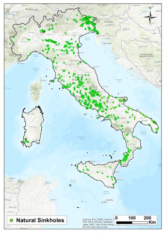
As of April 2025, more than 15,000 cases of natural sinkholes have been recorded and studied by ISPRA in lowland areas, plateaus, or foothill zones. Detailed on-site inspections and analyses have been conducted on hundreds of these cases.
Areas susceptible to natural sinkholes are concentrated on the central Tyrrhenian side, particularly in Friuli-Venezia Giulia, Lazio, Puglia, Abruzzo, Campania, and Tuscany.
The Adriatic side, especially the Marche region, due to its geological-structural features, is less affected by such phenomena, as are the Alpine Arc and the Dolomites, except for Friuli-Venezia Giulia and the Veneto plateaus.
Anthropogenic sinkholes constitute another category, as they are connected to underground cavities created by humans (anthropogenic sinkholes), mostly for the extraction of construction materials. Many cities are affected by this phenomenon, especially large urban areas built on land previously used for mining activities, such as Rome, Naples, Cagliari, Palermo, Reggio Calabria, and Turin. Thousands of cases have also been recorded in small and medium-sized towns with widespread underground networks. As of 2024, approximately 4,500 anthropogenic sinkholes have been recorded in Rome, over eight hundred in Naples, and several hundred in Cagliari and Palermo.
SUBSIDENCE-AFFECTED MUNICIPALITIES
Data aggiornamento scheda:
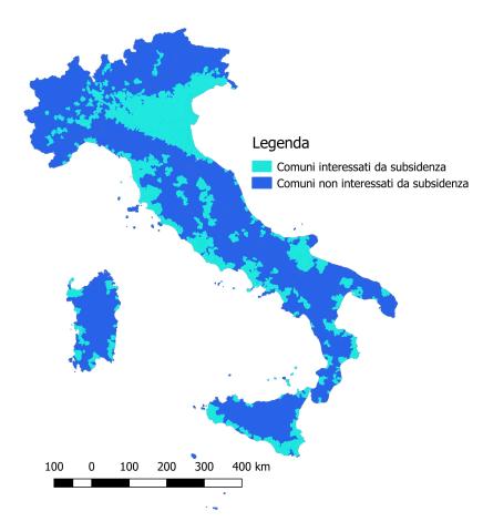
According to the collected data, subsidence affects approximately 18% of Italian municipalities, primarily in Northern Italy, particularly in the Po Valley. In Central and Southern Italy, the phenomenon mainly affects coastal plains. The most affected regions are Veneto and Emilia-Romagna, where over 50% of municipalities experience subsidence.