Valerio Comerci
The indicator describes seismic events that occurred in Italy during the reference year, based on Magnitude values recorded by the National Seismic Network of INGV. In 2024, no destructive earthquakes occurred in Italy. Only one event reached Magnitude 5 in the province of Cosenza, which nonetheless caused no significant surface effects. Additionally, 13 events with Magnitudes between 4 and 4.6 were recorded within Italian territory and across borders up to 100 km away. The number of earthquakes with Magnitude ≥ 2 in 2024 (2,031) is comparable to the number recorded in the previous five years, with a slight decrease in 2021. As usual, most events were concentrated along the Apennine arc, the Eastern Alps, and Eastern Sicily.
The indicator represents seismic events relevant to seismic risk. National seismicity is shown, with a focus on the most significant Magnitude events. The indicator provides useful information for defining seismic hazard in Italy.
To describe the seismic hazard in Italy based on recorded Magnitudes. The indicator helps disseminate knowledge on seismic hazard in Italy, essential for proper territorial planning.
No regulations are directly linked to this indicator. However, both national and regional regulations exist regarding seismic classification and construction in seismic zones (see indicators Seismic Classification and Seismic Microzonation).
- Pignone M., Amato A., 2025. Speciale 2024, un anno di terremoti. https://ingvterremoti.com/2025/01/13/speciale-2024-un-anno-di-terremoti/
- https://rischi.protezionecivile.gov.it/it/vulcanico/vulcani-italia/campi-flegrei/il-bradisismo-ai-campi-flegrei/lattuale-crisi/
- De Landro, G., Vanorio, T., Muzellec, T. et al. 3D structure and dynamics of Campi Flegrei enhance multi-hazard assessment. Nat Commun 16, 4814 (2025). https://doi.org/10.1038/s41467-025-59821-z
- SiGeA, 2018. Rischio sismico in Italia: analisi e prospettive per una prevenzione efficace in un Paese fragile. Geologia dell'Ambiente. Supplemento al n. 1/2018. ISSN 1591-5352
- Comerci V., 2006, Il Rischio Sismico in Italia. In: Signorino M. & Mauro F. (a cura di), Disastri Naturali. Conoscere per prevenire. ISAT, con la collaborazione del Dipartimento della Protezione Civile, Roma, pp.19-43.
No limitations.
None.
INGV (National Institute of Geophysics and Volcanology)
INGV website - http://terremoti.ingv.it/
National
2000-2024
Information from http://terremoti.ingv.it/ has been processed using GIS. Additional information on earthquake-induced effects has been derived from ISPRA surveys and other sources. For details on environmental effects, refer to the indicators Environmental Effects of Earthquakes and Surface Faulting.
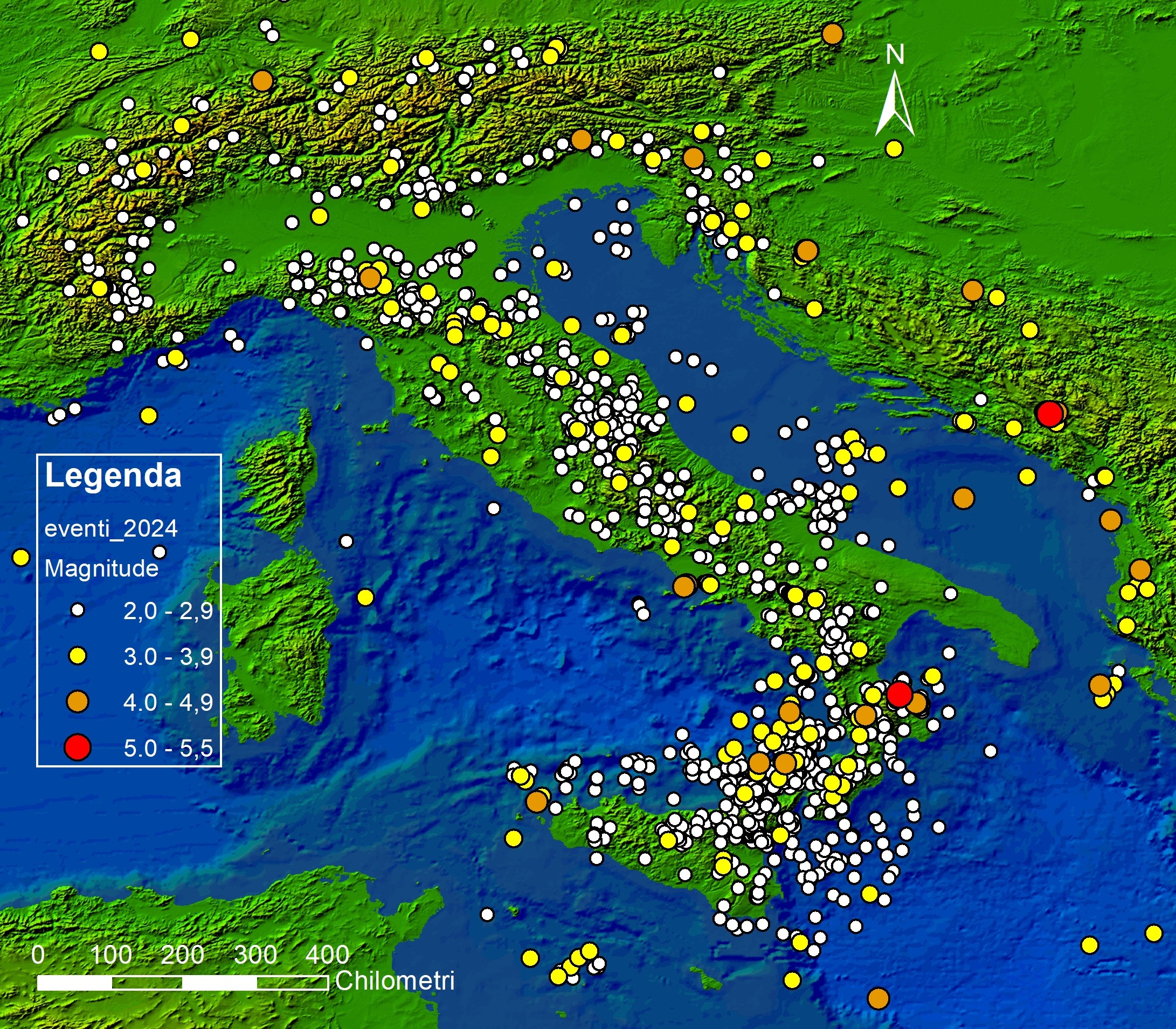
In 2024, 2,031 seismic events with Magnitude ≥ 2 occurred in Italy and within 100 km across borders (Figure 1). Including events beyond 100 km in neighboring countries, the National Seismic Network recorded 2,089 earthquakes. No events in Italy reached Magnitude 6. The strongest event, Mw 5.0, occurred on 01/08/2024, 4 km southwest of Pietrapaola (Cosenza Province). It caused no damage and was followed by a minor aftershock sequence lasting until September 2024. Thirteen additional events with Magnitudes between 4 and 4.6 occurred, none causing damage, except for the event on 20/05/2024 at Campi Flegrei (Md 4.4), which, due to its shallow depth of only 3 km, caused cracks and falling cornices, alarming the local population.
As usual, seismic events were mainly distributed along the Apennine arc, Calabria, Northern and Eastern Sicily, and to a lesser extent along the Eastern Alps (Figure 1). Although reduced compared to previous years, aftershocks from the 2016-2017 Central Italy seismic sequence still account for approximately 30% of total seismicity (Pignone & Amato, 2024). Deep earthquakes offshore Calabria continue, due to ongoing subduction of the Ionian oceanic crust beneath the Calabrian arc.
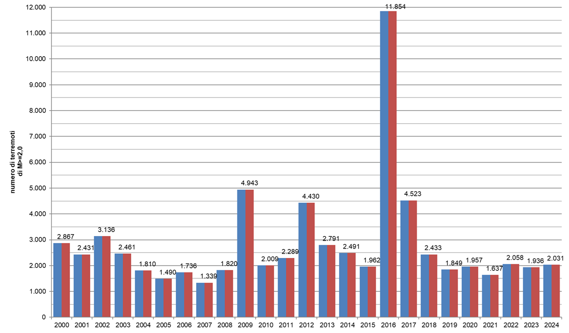
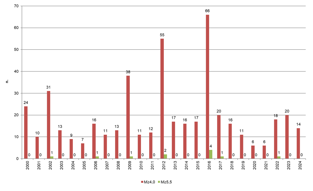
Seismicity in 2024 was comparable to the previous five years (except for a slight drop in 2021) for events with Magnitude ≥ 2, and lower than in 2009, 2012, and 2016–2017, which were characterized by sequences with events close to or exceeding Magnitude 6. As in previous years since 2018, no event reached Magnitude 5.5. Only one event reached Magnitude 5. The number of events between Magnitude 4 and 5.5 decreased compared to last year (14 compared to 20), but was higher than 2019–2021.
| Data |
|---|
Headline
Table 1: Earthquakes with Magnitude Equal to or Greater than 4 Occurred in Italy in 2024 Data source
Data legend
ML = Local Magnitude; Mw = Moment Magnitude |
Thumbnail
Headline
Figure 1: Seismic Events with Magnitude Equal to or Greater than 2 Occurred in 2024 in Italy and Surrounding Areas Data source
Processed by ISPRA based on INGV data (http://terremoti.ingv.it/) |
Thumbnail
Headline
Figure 2: Annual Series from 2000 to 2024 of Earthquakes with Magnitude Equal to or Greater than 2 Occurred in Italy and Cross-Border Areas up to a Distance of 100 km Data source
Processed by ISPRA based on INGV data, http://terremoti.ingv.it/ |
Thumbnail
Headline
Figure 3: Annual Series from 2000 to 2024 of Earthquakes with Magnitude Equal to or Greater than 4 and 5.5 Occurred in Italy and Cross-Border Areas up to a Distance of 100 km Data source
Processed by ISPRA based on INGV data, http://terremoti.ingv.it/ |
Fortunately, no significant damage to people or property occurred in 2024. Of the 2,031 events with Magnitude ≥ 2 recorded by INGV (Figure 1), only one reached Mw 5 in Cosenza Province. Of the other 13 events with Magnitude ≥ 4 (Table 1), only the event on 20/05/2024 (Md 4.4) at Pozzuoli (Campi Flegrei) caused damage. Hypocentral depths ranged from less than 1 km to 360 km, though most events occurred within the first 30 km, typical of crustal earthquakes. The shallowest events were recorded in volcanic areas such as Campi Flegrei; the deepest, in the Southern Tyrrhenian, are related to Ionian subduction.
Seismic sequences continued at Campi Flegrei in 2024: the ongoing caldera uplift that began in 2005 reached a maximum of about 132.5 cm at Rione Terra (Pozzuoli) by late August 2024, with 30.5 cm uplift since January 2023. Since 2018, this uplift has been accompanied by a gradual increase in both the number and magnitude of earthquakes. The Md 4.4 event in 2024 prompted extraordinary activation of the national civil protection system to support the Campania Region, as per the Minister for Civil Protection’s Decree of 30 May 2024. The mobilization was terminated on 10 July 2024. The bradyseismic crisis led to strengthened monitoring and prevention activities. The Major Risks Commission confirmed the presence of magma at depth as the triggering cause of the current crisis but, in the absence of evidence of magma ascent, maintained the "yellow alert level" for volcanic risk. Monitoring and prevention efforts are being intensified (https://rischi.protezionecivile.gov.it/it/vulcanico/vulcani-italia/campi-flegrei/il-bradisismo-ai-campi-flegrei/lattuale-crisi/). Recent studies identified a subsurface model with a first 2 km layer acting as a seal, an intermediate 2–4 km reservoir containing pressurized water, vapor, and CO₂, and a stable carbonate basement at depth (De Landro et al., 2025). No magma was found above 4.5 km depth.
Nationally, the absence of Magnitude ≥ 6 events, typically associated with long aftershock sequences, kept 2024 seismicity lower than years like 2016 (Figure 2). The years with the most seismic activity correspond to destructive sequences in Molise (2002), L’Aquila (2009), Emilia (2012), and Central Italy (2016). In Central Italy, aftershocks still continued in 2024, accounting for ~30% of total seismicity (Pignone & Amato, 2024). The number of earthquakes in 2016 was more than double that of 2009 and 2012, and about triple that of 2002, highlighting the much higher energy release in 2016, when a Mw 6.5 mainshock followed a Mw 6 event (4 events Mw ≥ 5.5; Figure 3). The number of Mw ≥ 4 events in 2024 is much lower than during previous major sequences: 66 events in 2016 and 55 in 2012. Years with more Mw ≥ 4 events also recorded more Mw ≥ 5.5 events (4 in 2016 and 2 in 2012). Figures 2 and 3 show that from 2002 to 2016, destructive earthquakes occurred every 3 to 7 years. Since 2016, more than 8 years have passed without destructive events. Historical records show that destructive earthquakes sometimes occurred yearly, such as the 14 major events between 1688 and 1706, and 6 events between 1915 and 1920 (Comerci, 2006). Sound prevention policies must account for these seismic characteristics.