Stefania Nisio
Sinkholes are depressions that open suddenly in the ground, with a sub-circular shape and variable diameter and depth, ranging from a few meters to hundreds of meters.
The inventory of sinkholes and the identification of at-risk areas are useful for studying the susceptibility of the territory to hydrogeological instability.
As of April 2025, more than 15,000 cases of natural sinkholes have been recorded and studied by ISPRA in lowland areas, plateaus, or foothill zones. Detailed on-site inspections and analyses have been conducted on hundreds of these cases.
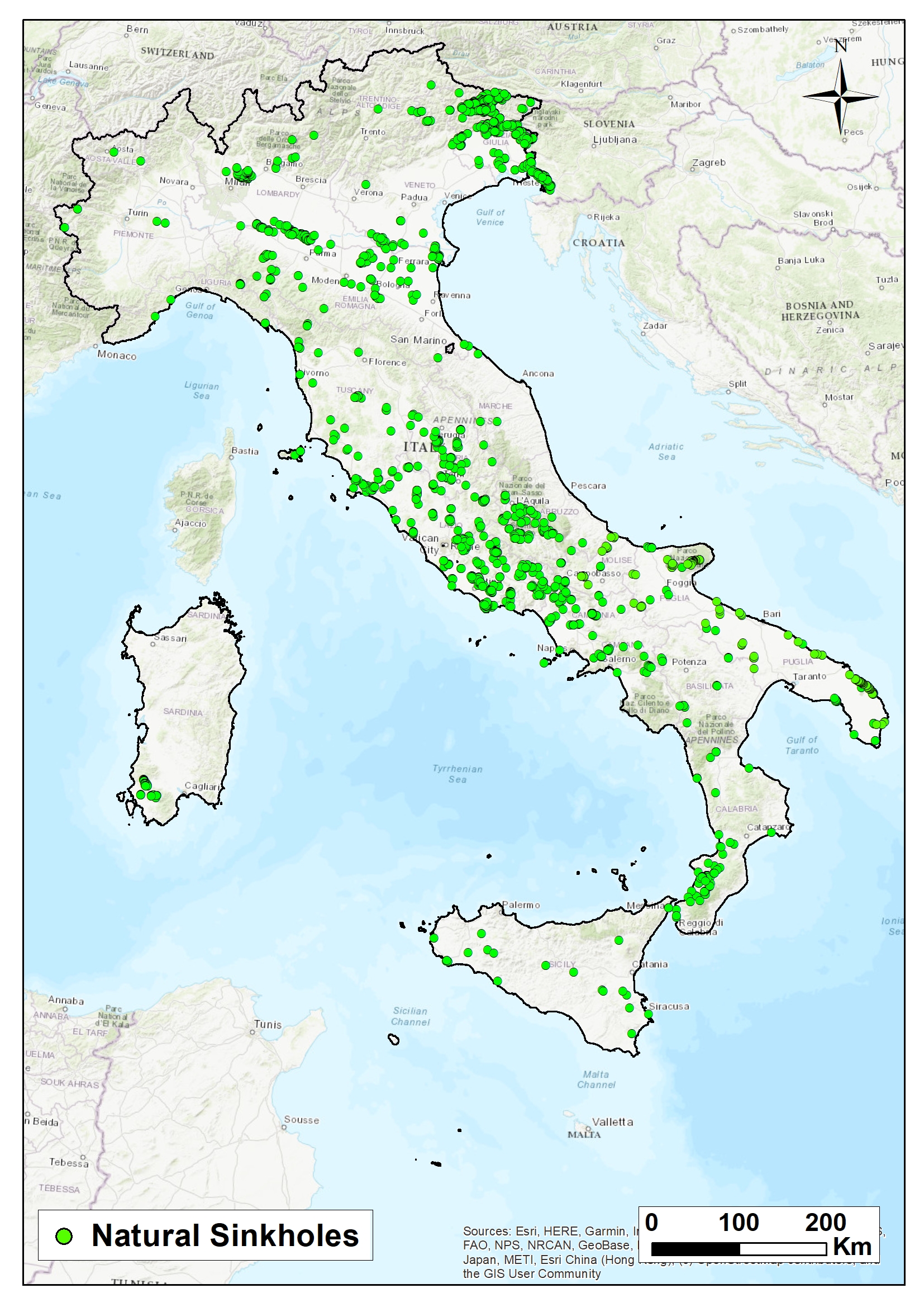
Areas susceptible to natural sinkholes are concentrated on the central Tyrrhenian side, particularly in Friuli-Venezia Giulia, Lazio, Puglia, Abruzzo, Campania, and Tuscany.
The Adriatic side, especially the Marche region, due to its geological-structural features, is less affected by such phenomena, as are the Alpine Arc and the Dolomites, except for Friuli-Venezia Giulia and the Veneto plateaus.
Anthropogenic sinkholes constitute another category, as they are connected to underground cavities created by humans (anthropogenic sinkholes), mostly for the extraction of construction materials. Many cities are affected by this phenomenon, especially large urban areas built on land previously used for mining activities, such as Rome, Naples, Cagliari, Palermo, Reggio Calabria, and Turin. Thousands of cases have also been recorded in small and medium-sized towns with widespread underground networks. As of 2024, approximately 4,500 anthropogenic sinkholes have been recorded in Rome, over eight hundred in Naples, and several hundred in Cagliari and Palermo.
L'indicatore consente di rappresentare le aree suscettibili ai fenomeni di sprofondamento improvviso, noti in letteratura con il termine di sinkholes. I sinkholes sono voragini che si aprono repentinamente nel terreno, in maniera catastrofica con diametro e profondità variabile da alcuni metri a centinaia di metri. Essi sono suddivisi in due grandi gruppi: sinkholes di origine naturale e sinkholes di origine antropogenica. I primi si originano per la presenza di cavità nel sottosuolo originatesi per cause naturali dipendenti dal contesto geologico - idrogeologico
The indicator makes it possible to represent areas susceptible to sudden ground collapses, known in the literature as sinkholes. Sinkholes are depressions that open suddenly and catastrophically in the ground, with diameters and depths ranging from a few meters to hundreds of meters. They are divided into two main groups: natural sinkholes and anthropogenic sinkholes.
Natural sinkholes form due to underground cavities that originate from natural causes related to the area's geological and hydrogeological context. Anthropogenic sinkholes, on the other hand, are directly caused by human activity and the presence of man-made underground cavities.
There are various types of natural sinkholes, depending on the triggering mechanism and the way the phenomenon spreads. Most natural sinkholes are related to karst processes of rock dissolution, and to a lesser extent, to suffosion-liquefaction processes (piping sinkholes). This latter type is the most dangerous and unpredictable, affecting mainly lowland areas with thick terrigenous covers and volcanic zones.
In both cases, sinkholes are sub-circular depressions, with variable diameter and depth from a few meters to hundreds, that can form within hours.
The processes that generate them are very complex and sometimes difficult to define, not attributable solely to gravity or karst dissolution, but to a series of predisposing and triggering factors: liquefaction, deep underground cavities, erodible surface deposits, tectonic features, faults or fractures, CO₂ and H₂S emissions, seismic events, heavy rainfall, human activities such as pumping, extraction, excavation, etc.
Depending on genetic factors and propagation modes (from bottom to top, within surface soils), sinkholes are classified into different types: those formed by dissolution alone, slow subsidence, or collapse. ISPRA's classification, based on Italian cases, includes: solution sinkhole, cover subsidence sinkhole, rock collapse sinkhole, cover collapse sinkhole, suffosion sinkhole, and piping sinkhole.
Piping sinkholes are the most distinctive and occur in Italian alluvial or coastal plains, forming depressions with diameters exceeding one hundred meters.
Natural sinkholes may fill with water: it is common for groundwater or rising water from deep aquifers to flow into the cavity, giving it the appearance of a small lake. These waters, often mineralized, may be fed by the shallow aquifer and/or springs at the bottom of the cavity.
Anthropogenic sinkholes are caused by human activity (anthropogenic sinkholes), i.e., the collapse of man-made underground cavities or malfunctions in utility networks, or a combination of both. They tend to occur in areas of intense urbanization and where historical underground excavation has taken place.
ISPRA has carried out an inventory of natural sinkholes in the Italian lowlands, based on literature and field studies. The inventory is now well updated and has enabled the creation of an Italian database.
Additionally, an inventory of anthropogenic collapses and underground cavities in provincial capital cities has been underway for several years.
NISIO S. (2008) - I fenomeni naturali di sinkhole nelle aree di pianura italiane. Monografia Memorie descrittive della Carta Geologica d’It. Vol. LXXXV; 475pp
NISIO S. (2010) - I sinkholes nelle aree di pianura italiane: i risultati del “Progetto Sinkhole” - Atti 2° Workshop internazionale: I sinkholes. Gli sprofondamenti catastrofici nell’ambiente naturale ed in quello antropizzato. Roma 3-4 dicembre 2009. ISPRA, 13-28.
BASSO N., CIOTOLI G., FINOIA M. G, GUARINO P. M., MIRAGLINO P., NISIO S., (2013) - Gli sprofondamenti nella città di Napoli. Mem. Descr. Carta Geol. D’IT. 93, 73-104.
CIOTOLI G. CORAZZA A., FINOIA M.G., NISIO S. SUCCHIARELLI C. (2013) – Gli sprofondamenti antropogenici nell’aria urbana di Roma. Mem. Descr. Carta Geol. D’IT. 93, 143-182.
ISPRA - NISIO S. (2013) - Fenomeni di sprofondamento in alcuni centri urbani. IX Rapporto sulla qualità dell’ambiente urbano.
ISPRA - NISIO S. (2012) - Fenomeni di sprofondamento in alcuni centri urbani. VIII Rapporto sulla qualità dell’ambiente urbano.
GUARINO P.M. & NISIO S. (2012) – Anthropogenic sinkholes in urban areas. A case study from Naples (Italy). Physics and Chemistry of earth. Elsevier. Special ISSUe, 49 (2012) 92–102ES.
ISPRA - NISIO S. (2011) - Fenomeni di sprofondamento in alcuni centri urbani. VII Rapporto sulla qualità dell’ambiente urbano.
MELONI F., NISIO S., LIPERI L., TONELLI V., ZIZZARI P. (2013) -Il Catalogo unificato dei sinkholes della regione Lazio. Mem. Descr. Carta Geol. D’IT. 93, 321-354.
MELONI F., NISIO S., LIPERI L., TONELLI V., ZIZZARI P. CIOTOLI G. (2013) -Carta dei sinkholes della Regione Lazio. Mem. Descr. Carta Geol. D’IT. 93.
GIUSTINI F., CIOTOLI G., FINOIA M.G. NISIO S. (2015) - Analisi geo-spaziale applicata alla valutazione della suscettibilità agli sprofondamenti nella piana del Fucino (Italia centrale). (2015) Mem. Descr. Carta Geol. D’It. 99, 273-284.
D’ANGELLA A., NISIO S., CIOTOLI G. (2015) - Applicazione di analisi statistica multivariata, rete neurale artificiale e metodo euristico per la valutazione della suscettibilità da sinkhole nella Piana di San Vittorino (RI). (2015) - Mem. Descr. Carta Geol. D’It. 99, 239-254.
CIOTOLI G., FINOIA M.G., LIPERI L., MELONI F., NISIO S., TONELLI V., ZIZZARI P. (2015) - Sinkhole susceptibility map of the Lazio Region, central Italy. Journal of Maps 1/2015
CIOTOLI G., DI LORETO E, LIPERI L., MELONI F., NISIO S., SERICOLA A. (2015) - Carta dei Sinkhole Naturali del Lazio 2012 e sviluppo futuro del Progetto Sinkholes Regione Lazio. Mem. Descr. Carta Geol. D’It. 99, 189-202.
CIOTOLI G., NISIO S., SERAFINI R. (2015) – Analisi della suscettibilità ai sinkholes antropogenici nel centro urbano di Roma: analisi previsionale. (2015) Mem. Descr. Carta Geol. D’IT. 99, 167-188.
CIOTOLI G., NISIO S., SERAFINI R. (2015) – Carta di suscettibilità ai sinkholes antropogenici nel centro urbano di Roma: analisi previsionale. (2015) Mem. Descr. Carta Geol. D’IT. 99, allegato.
CIOTOLI G., NISIO S., AMANTI M. (2016) - La Suscettibilità di Roma ai sinkholes antropogenici. professione Geologo, Ordine Geologi del lazio
MELONI F. & NISIO S. (2015) - Catalogo dei Sinkhole Antropogenici del Lazio 2013 ed organizzazione delle attività future. (2015) Mem. Descr. Carta Geol. D’It. 99, 245-254. ISBN 978 – 88-9311-009-9
CIOTOLI G., NISIO S., AMANTI M. (2016) - La Suscettibilità di Roma ai sinkholes antropogenici. professione Geologo, Ordine Geologi del Lazio.
ISPRA - NISIO S., ALLEVI A., CIOTOLI G., FERRI G., FIORE R., PASCUCCI R., STRANIERI I., SUCCHIARELLI C., (2017) Carta delle Cavità sotterranee di Roma.
C. CALLIGARIS, L. ZINI, S. NISIO, C. PIANO (2019) - Sinkholes in the Friuli Venezia Giulia Region: state of the art of the of territorial analyses in the evaporites. Springer Book “Applied Geology: Approaches to Future Resource.
NISIO S. (2019) - La Carta delle cavità Antropogeniche di Roma Capitale. Quaderni Ordine degli Ingegneri di Roma, 2019.
F. BISCONTI, G. CIOTOLI, G. FERRI, R. FIORE, M. LANZINI, S. NISIO, R. PAOLUCCI, M. ROMA, I. STRANIERI, C. SUCCHIARELLI ALLEVI M. (2018) - Primo contributo alla realizzazione della carta delle cavità sotterranee di Roma. SIGEA - Soc. It. di Geol. Amb., Geologia dell’Ambiente 4/2018
ISPRA . NISIO S. (2018) – I sinkholes antropogenici nelle città Italiane -Qualità dell’ambiente urbano – XIV Rapporto 2018. ISPRA Stato dell’Ambiente 82/18, 149-158.
Calligaris C., Zini L., Nisio S., Piano C. (2020) - Sinkholes in the Friuli Venezia Giulia Region: state of the art of the of territorial analyses in the evaporites. Springer Book “Applied Geology: Approaches to Future Resource, Springer Chapter 5, 73-90 DOI:10.1007/978-3-030-43953-8_5; ISBN 978-3-030-43952-1.
Madonna S., Nisio S., Nappi G. (2020) - Le Cavità antropiche presenti nel sottosuolo di Bolsena Mem. Descrittive della carta geologica d’Italia. Vol 107, 383-396.
Madonna S., Nisio S. Gandin A., (2020)- Le cavità nascoste nei “calcareous tufa” del sottosuolo di Rieti. Mem. Descrittive della carta geologica d’Italia. Vol 107, 357-382.
Tufano R., Guerriero L., Annibali Corona M., Bausilio G. , Di Martire D. , Nisio S. , Calcaterra D. (2022) - I sinkholes antropogenici nel territorio di Napoli:aggiornamento dell’inventario ai fini della valutazione disuscettibilità. Anthropogenic sinkholes in the city of Naples: updating of the inventory for susceptibility analysis. Memorie Descrittive della Carta Geol- d’It. 109, 321-332.
Tufano R., Guerriero L., Annibali Corona M., Bausilio G., Diego Di Martire, Nisio S., Calcaterra D. (2021) - Anthropogenic sinkholes inventory of the city of Naples, Italy: an update. Natural Hazard. https://doi.org/10.1007/s11069-022-05279-x
Luca Maria Puzzilli , Valerio Ruscito, Sergio Madonna, Francesco Gentili, Livio Ruggiero, Giancarlo Ciotoli and Stefania Nisio (2024) - Natural Sinkhole Monitoring and Characterization: The Case of Latera Sinkhole (Latium, Central Italy) Geosciences 2024, 14, 18. https://doi.org/10.3390/geosciences14010018
The limitations are due to the difficulty of acquiring specific information for the inventory, lack of coordination with regional Geological Services, problems in accessing deep geological surveys and historical records needed to date the events.
It is necessary to conduct geological and hydrogeological surveys in other areas of the national territory (Sardinia, northern Apennines, Po Valley, etc.), and collect information through a collaborative network with local entities, historical investigations, and data from geognostic surveys. Sampling and geochemical and geotechnical analyses are also needed to understand the physical characteristics of the waters in natural cavities and the physico-mechanical properties of soils affected by suffosion.
ISPRA
https://sgi.isprambiente.it/sinkholeweb/
National
2000-April 2025
Survey and location of sinkhole phenomena recorded throughout Italian territory.
Natural sinkholes are less frequent than anthropogenic ones but much more devastating.
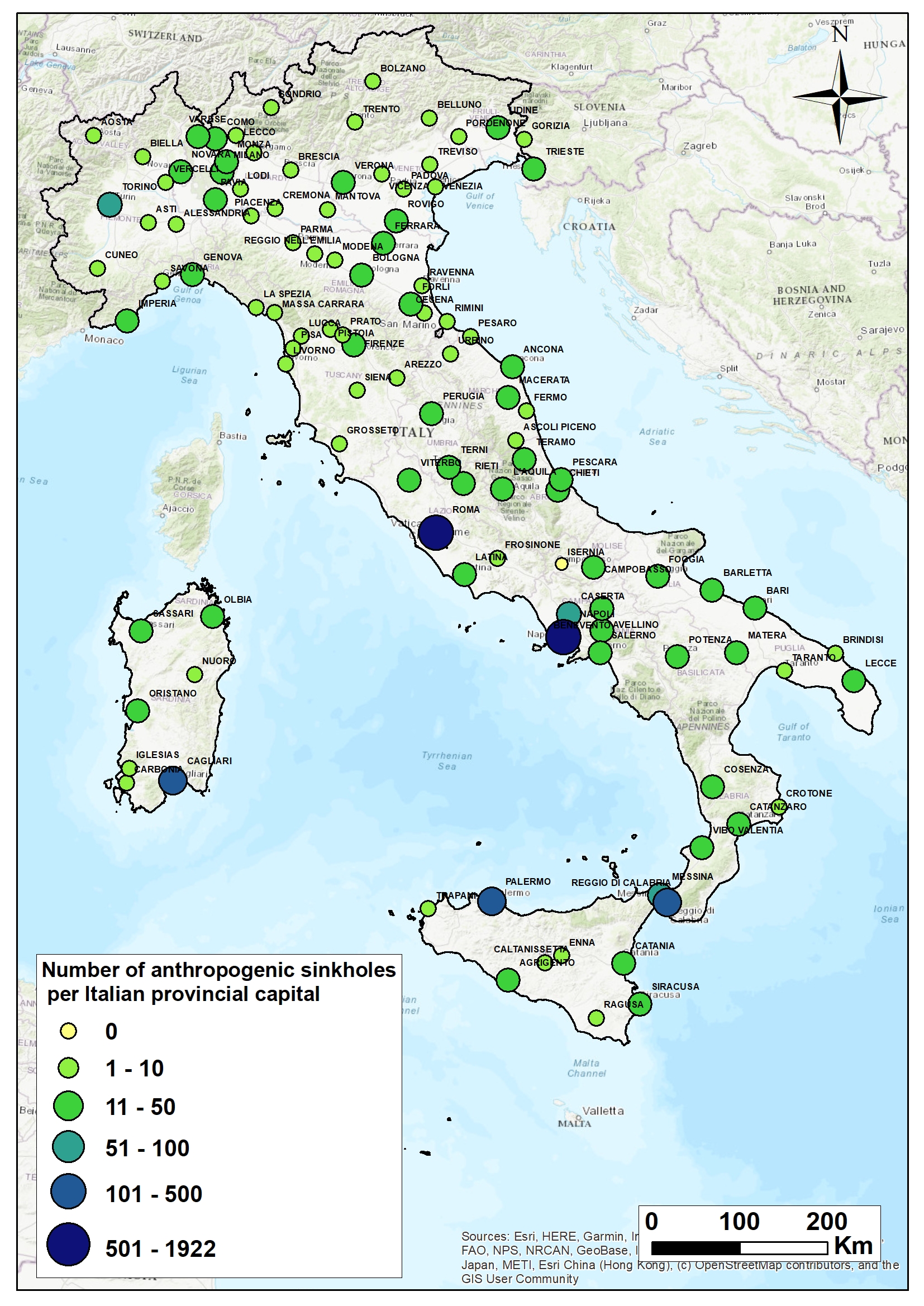
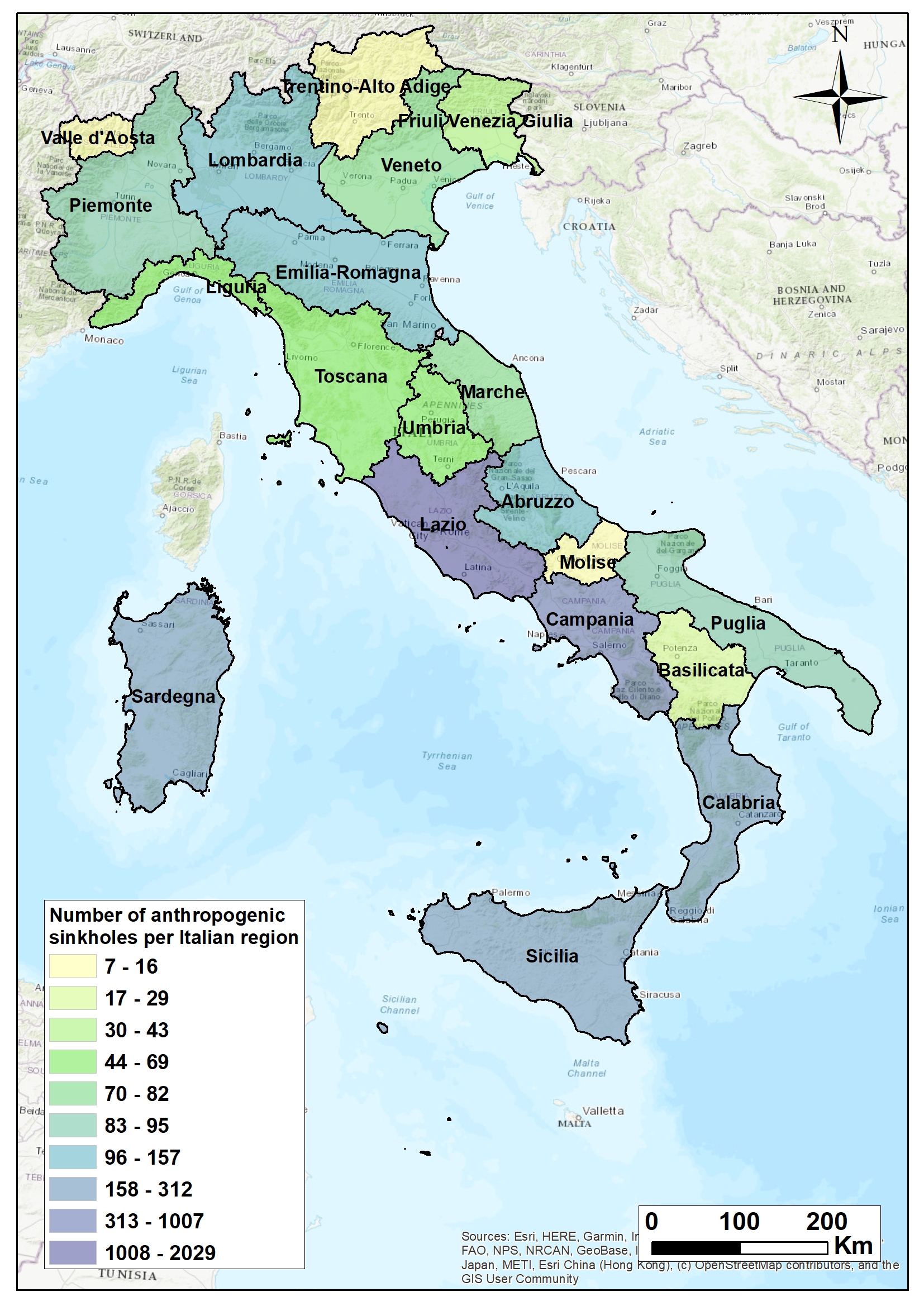
Anthropogenic sinkholes are very frequent and continue to increase in large metropolitan areas (Rome and Naples).
In 2024, a large sinkhole opened in the Quadraro neighborhood of Rome, near Via Menas; another large one opened in the Vomero district of Naples near Via Morghen.
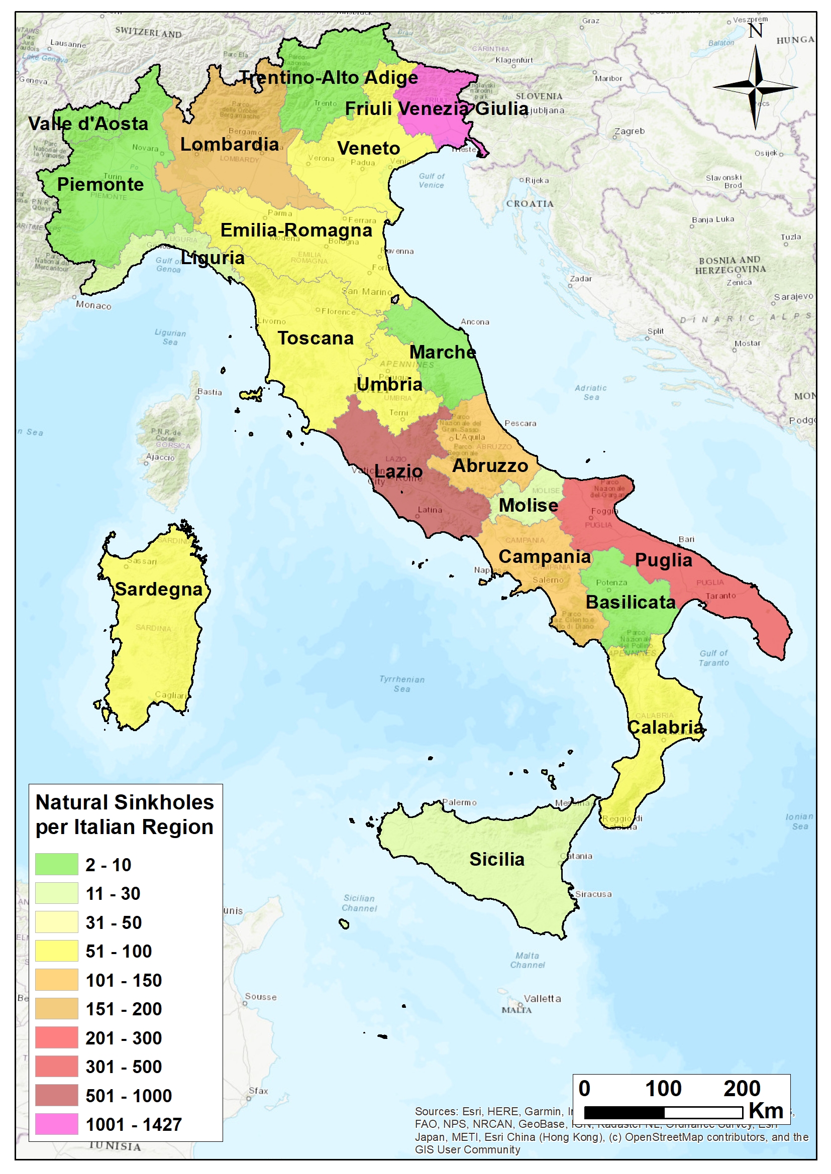
The trend is clearly increasing, as confirmed by the number of sinkholes opening in large metropolitan cities (Figures 3 and 4) and the overall rise in cases in provincial capitals (Figure 2).
| Allegati |
|---|
Thumbnail
Titolo
Figure 1: Distribution of natural sinkholes in the Italian territory (April 2025) Fonte
ISPRA |
Thumbnail
Titolo
Figure 2: Distribution of natural sinkholes in regional territories (April 2025) Fonte
ISPRA |
Thumbnail
Titolo
Figure 3: Distribution of anthropogenic sinkholes in Italian provincial capital cities (2024) Fonte
ISPRA |
Thumbnail
Titolo
Figure 4: Distribution of anthropogenic sinkholes in Italian regions (2024) Fonte
ISPRA |
In Italian plains, natural sinkhole events not strictly related to karst processes are common, due to thick layers of semi-permeable sedimentary soils over the bedrock (solid rock beneath superficial materials such as soil and gravel). These depressions may be linked to liquefaction (piping), deep suffosion, and groundwater level fluctuations due to various causes.
Such phenomena are more widespread than previously thought and have occurred in Italy since historical times, when their causes and mechanisms were unknown.
Historical sources confirm that catastrophic sinkholes were already known in Roman times and have occurred every century in the same areas, where earlier events had been filled in naturally or artificially.
As of April 2025, more than 15,000 natural sinkhole cases in plains and plateaus have been recorded and studied by ISPRA through field investigations and archival research.
These events are concentrated in intramontane basins, alluvial valleys, and coastal plains; some are also found in foothill belts connecting to lowlands and in small inter-hill depressions.
Many of the recorded events are believed to be connected to the rise of aggressive fluids.
Susceptible areas are concentrated on the central Tyrrhenian side (Figures 1 and 2), especially in Friuli-Venezia Giulia, Lazio, Puglia, Abruzzo, Campania, and Tuscany.
The Adriatic side, particularly Marche, due to its geological-structural makeup, is not affected by this type of sinkhole, nor are the Alpine Arc and the Dolomites.
In northern Italy (where the inventory is still ongoing), conditions differ.
In the plains of Veneto and Emilia-Romagna, particularly in the Po Valley where the Po meets the Adige River, numerous small sub-circular lakes are found, attributed to erosive evorsion processes (vertical turbulence-induced erosion) in sedimentary bodies with considerable sandy material, or to liquefaction and suffosion processes.
In the Po Valley and Lombardy plains, small-diameter and shallow sinkholes (called occhi pollini) are widespread; their likely surface suffosion origin is currently under investigation.
In the plains and internal basins of Veneto, Friuli-Venezia Giulia, and the Autonomous Province of Bolzano, sinkholes are tightly linked to the dissolution of evaporitic and carbonate lithotypes found beneath thin cover layers, classified as cover-collapse sinkholes.
In Calabria, the reported phenomena are mostly filled-in depressions and small lakes of difficult localization, all originating during seismic events and connected to soil liquefaction.
The geological context differs in Sicily and Puglia, where sinkholes are influenced by the presence of evaporitic (gypsum and salt) or calcareous terrains and thinner clay or sandy cover layers.
Anthropogenic sinkholes mostly occur in major metropolitan cities and are primarily connected to underground cavities (Figures 3 and 4).