Panel 1
Valerio Comerci, Roberto Pompili
The indicator describes the environmental effects induced by earthquakes and represents the susceptibility of the Italian territory to such effects. Susceptibility depends on the varying degrees of seismicity present in different portions of the Italian territory and the local geomorphological and geological characteristics. It also provides a map of the ESI (Environmental Seismic Intensity) values reached during known seismic history in Italy, representative of the effects that may occur again in the future due to similar earthquakes.
In 2022, only one earthquake was recorded in which seismic-induced environmental effects were reported. This was the earthquake that occurred on December 4, 2022, in the Aeolian Islands, with a magnitude of 4.5, which induced modest collapse phenomena in some sites on Lipari and Vulcano.
Earthquakes, in addition to directly damaging buildings, cultural heritage, and infrastructure due to shaking, also cause environmental effects. These environmental effects can be classified into primary and secondary effects. Primary effects consist of permanent deformations of the topographic surface, such as surface faulting, subsidence or uplift of portions of the land.
Secondary effects are those primarily linked to the shaking, such as seismic-induced landslides, liquefaction of granular soils, and ground fractures. Earthquakes also generally induce hydrological changes in the regime of springs and can generate anomalous waves (tsunamis) both at sea and in smaller inland basins.
The indicator describes the environmental effects induced by new earthquakes and, through maps of the earthquake intensities that occurred in the past, represents possible scenarios in terms of environmental effects that may occur in Italy in the event of future earthquakes of similar intensity.
To describe the seismic-induced environmental effects in the case of new earthquakes and to represent the susceptibility of the Italian territory to such effects. This susceptibility depends on the seismic characteristics present in different portions of the Italian territory, as well as the local geomorphological and geological characteristics.
Not applicable.
Panel 2
TUVÈ T., MANNI M., PRUITI L., AZZARO R., BOTTARI C., GIAMPICCOLO E., MUSUMCI C. (2023). Rilievo Macrosismico del Terremoto Eoliano del 4 Dicembre 2022 – ore 08:12 locali. Rapporto interno INGV, http://hdl.handle.net/2122/16122
http://terremoti.ingv.it/
VITTORI E., COMERCI V., (Eds.), 2004, The INQUA Scale. An innovative approach for assessing earthquake intensities based on seismically-induced ground effects in natural environment. Special Paper, Memorie Descrittive della Carta Geologica d’Italia, Vol. LXVII, APAT, pp.118.
GUERRIERI and VITTORI (Eds), 2007, Intensity Scale ESI2007. Mem. Descr. Carta Geologica d’Italia, Vol. LXXIV. Servizio Geologico d’Italia, Dipartimento Difesa del Suolo, APAT, Rome, Italy.
SILVA, P. G., RODRIGUEZ PASCUA, M. A. et al., 2008. Catalogacion de los efectos geologicos y ambientales de los terremotos en Espana en la Escala ESI-2007 y su aplicacion a los estudios paleosismologicos. Geotemas, 6, 1063–1066.
ROVIDA A., LOCATI M., CAMASSI R., LOLLI B., GASPERINI P., ANTONUCCI A. (2022). Catalogo Parametrico dei Terremoti Italiani (CPTI15), versione 4.0. Istituto Nazionale di Geofisica e Vulcanologia (INGV). https://doi.org/10.13127/CPTI/CPTI15.4
GUERRIERI (Ed.), 2015, Earthquake Environmental Effect for seismic hazard assessment: the ESI intensity scale and the EEE Catalogue. Mem. Descr. Carta Geol. D’It., XCVII.
SERVA L., VITTORI E., COMERCI V., ESPOSITO E., GUERRIERI L., MICHETTI AM., MOHAMMADIOUN B., MOHAMMADIOUN G., PORFIDO S., TATEVOSSIAN R., 2015, Earthquake Hazard and the Environmental Seismic Intensity (ESI) Scale. Pure Appl. Geophys. Springer Basel. DOI 10.1007/s00024-015-1177-8
Reicherter K., Michetti a.M., Silva Barroso P.G., 2009. Palaeoseismology: historical and prehistorical records of earthquake ground effects for seismic hazard assessment. The Geological Society, London, Special Publications, 316, 1–10. DOI: 10.1144/SP316.1
The ESI intensity has been attributed only to the locations listed in the Parametric Catalogue of Italian Earthquakes CPTI15 v4.0 (Rovida et al., 2022), to which a maximum intensity has been assigned following known earthquakes from the year 1000 to 2022. Therefore, there is no information available on other areas of the national territory where future earthquakes may occur.
Further studies on past seismicity could improve information on the susceptibility of the national territory.
Data quality assessment
INGV (National Institute of Geophysics and Volcanology)
Civil Defense
Baseline information is derived from the macroseismic survey performed by INGV following the December 4, 2022 earthquake (Tuvé et al., 2023), information provided by the Lipari Municipality's Civil Defense Service, and news found via the web.
National
2022 for the description of seismic-induced environmental effects. From the year 1000 to 2022 for the ESI intensity map in Italy.
Indicator assessment
Collection of environmental effects induced by new earthquakes and attribution of ESI intensities (Environmental Seismic Intensity). ESI intensities have also been attributed to past events with a macrosismic intensity of degree VI or higher, as only from this intensity environmental effects are measurable.
The earthquake that occurred in the Aeolian Islands on December 4, 2022, is the only event in the year for which seismic-induced environmental effects were reported, specifically minor landslide collapses. Based on the analysis of the effects, an ESI intensity of IV-V was assigned as the maximum intensity reached by the earthquake. It should be noted that seismic-induced environmental effects are strictly tied to the geological and geomorphological characteristics of the location where they occur and to the seismicity magnitude. Therefore, it is not possible to provide an evaluation of the state. Being phenomena that are part of the natural evolution of the territory, there is no reference level against which the state can be correlated.
Seismic-induced environmental effects are closely related to seismic intensity and the geological and geomorphological characteristics of the location where they occur. It is not possible to provide a trend evaluation.
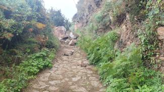
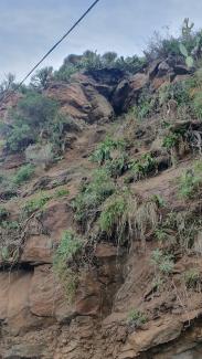
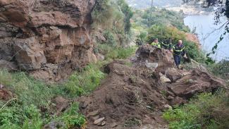
For the population of this indicator, the 19 earthquakes that occurred in 2022 with a magnitude of 4.0 or higher (see Table 1 of the "Seismic Events" indicator) were considered to check if they induced any significant environmental effects. Of the 19 events, 7 occurred at a depth of over 20 km, which is too deep to induce environmental effects, given that the magnitudes did not exceed Mw 5.5. Of the 12 events that occurred at a hypocentral depth of less than 20 km, the only one for which environmental effects were reported is the earthquake of December 4, 2022, in the Aeolian Islands with a magnitude of Mw 4.5, which occurred at a depth of 3.1 km (source: https://terremoti.ingv.it/event/33554561), with the epicenter located approximately 9 km southwest of Vulcano Island (epicentral coordinates 38°31'7.20''N; 14°51'23.40''E).
This earthquake induced secondary effects on the ground in various locations on the islands of Lipari and Vulcano, including collapses and landslides. These were reported in a report following an INGV field survey (Tuvè T., Manni M., Pruiti L., Azzaro R., Bottari C., Giampiccolo E., Musumeci C., 2023. Macrosismic Survey of the 4th December 2022 Aeolian Earthquake – 08:12 local time. Internal INGV Report, http://hdl.handle.net/2122/16122) and from the local Civil Protection Service of Lipari (ME). In the Capistello area, located in the southern part of the island, a rock collapse of several cubic meters occurred. The fallen rocks blocked a paved path above the so-called Villaggio Francese (Figures 1, 2, 3). Other collapses were recorded in the Mendolita area, just west of the town of Lipari, as well as in the Falcone area and at Valle Muria Beach, where part of a rock slope collapsed into the sea. The earthquake did not cause any fatalities and resulted in minor damage in various inhabited areas, including Lipari. Except for the blockage of the pedestrian road at Capistello, the landslides induced by the earthquake did not cause damage to buildings. On Vulcano Island, the aforementioned INGV report also documented two rockfalls on Monte Lentia.
From the overall picture of the environmental effects induced by the seismic sequence, it is clear that the maximum ESI intensity reached is IV-V, as the environmental effects were sporadic and of small size.
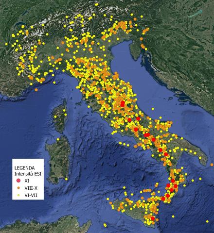
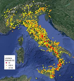
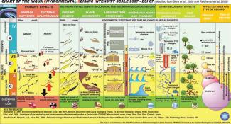
The various areas of Italy have different susceptibilities to the environmental effects of earthquakes, depending on local seismic, geomorphological, and geological characteristics. To represent this diversity, the maximum intensities (MCS, Mercalli Cancani Sieberg) reached throughout the seismic history of the country were considered and converted into ESI intensities (Environmental Seismic Intensity), according to the ESI2007 Scale. Figure 4 shows the ESI intensities related to known historical earthquakes that occurred from the year 1000 to 2022, with MCS intensities of VI or higher. Since both the ESI and MCS scales are based on 12 degrees, the MCS intensities were directly converted into ESI without changes. This empirical correspondence is based on comparisons between events where both scales have been applied. However, it is statistically possible that there may occasionally be a one-degree difference between the two scales, and in very rare cases, a two-degree difference. Each ESI intensity corresponds to a defined environmental effects scenario, which is described in terms of primary and secondary effects in the ESI scale. Environmental effects become clearly appreciable starting from degree VI, and they manifest more visibly as intensity increases. For degrees VIII to X, environmental effects are a characteristic component of the intensity of the earthquake; for degrees XI and XII, they are the most reliable tool for evaluating intensity.
Figure 5 provides a graphical representation of the environmental effects that can be induced by earthquakes of varying intensities. Given that the intensities of past earthquakes are indicative of the potential damage that could occur again in the future, the data presented in Figure 5 represent possible scenarios, in terms of environmental effects, that could occur in different parts of the country in the case of earthquakes similar to those that happened in the past. This type of knowledge is relevant, among other things, for achieving the long-term goal of the 8th Environment Action Program to 2030, which aims to achieve greater resilience to environmental risks by 2050. Knowing the potential effects that may occur in a territory following an earthquake can help take necessary precautionary measures to prevent significant damage to the environment and to sensitive structures and infrastructures (such as appropriately protecting facilities at risk of major accidents, pipelines, gas lines, etc.)