Maria Luisa Cassese, Filippo D'Ascola, Valeria Pesarino, Andrea Salmeri
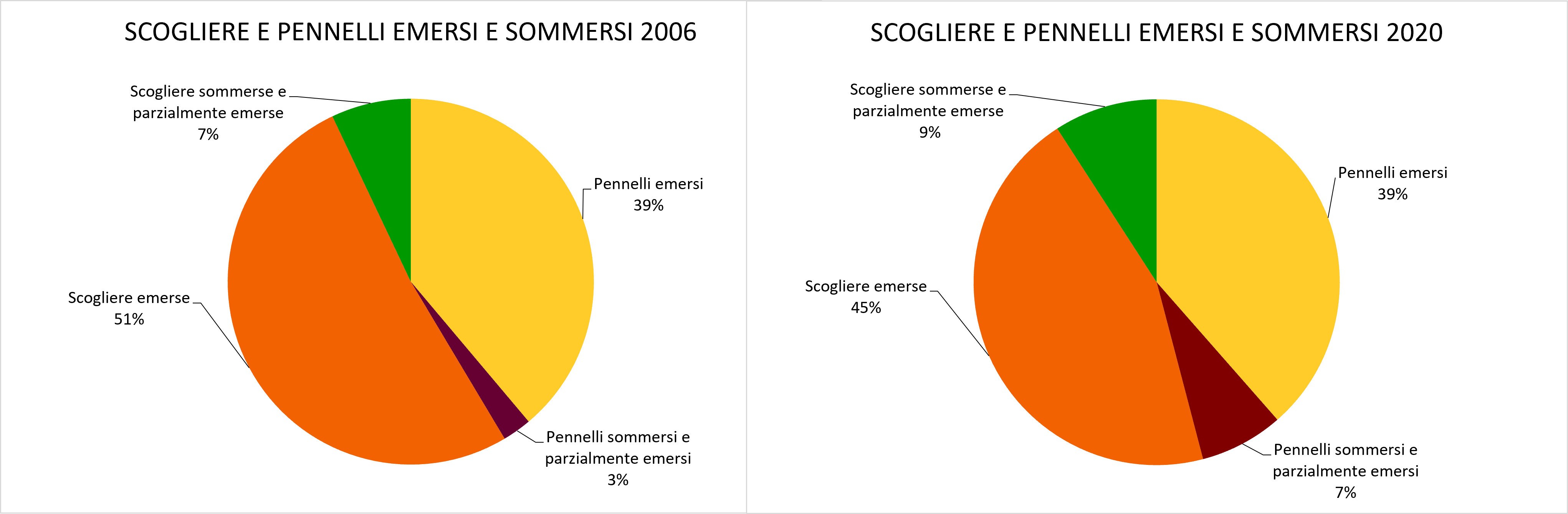
To contain erosion and damage caused by storms along the Italian coasts, defense interventions are often carried out aimed at protecting goods and infrastructure and restoring beaches. The indicator “coastal defense works” provides the number, on a national and regional basis, of the different types of “rigid” works of coastal defense (islots, mixed works, brushes, grazing and cliffs) and their variation over time. From 2000 to 2020, if on the one hand it was possible to find an increase in the number of rigid defense works (from about 6,600 to 10,500) indicative of the fragility of coastal environments subjected to increasing anthropogenic pressure; on the other hand, the increasing adoption of submerged or partially emerged defense solutions (from 10% in 2006 to 16% in 2020) shows the trend towards the search for a compromise between the hydraulic efficiency of a lesser impact.
In recent years, the retreat of the shoreline, as well as posing a threat to the tourism-bathing sector, puts at risk the safety of homes, roads and railways, affecting, more generally, several socio-economic activities. For these reasons, for several years we have been developing techniques for the planning, design and execution of coastal defense works. The solutions of protection of the coasts and the containment of erosion, adopted over the years by the local administrations, are both interventions with “rigid” coastal defense works, that is, fixed structures capable of interfering with the wave motion and limiting the harmful effects of storm surges, and interventions with “soft” works, which provide for the restoration of beaches with artificial repaslocations. In principle, the longitudinal and detached defense works from the shore (e.g. reefs or artificial islets) allow to attenuate the action of the waves on the coast and to limit the instability of the coasts during storm events; while crosses works to the shoreline (for example brushes) allow to change locally the dynamics of erosion/acresment of the beaches. To counteract the aggressive action of the sea, combined solutions of transverse and longitudinal structures are also adopted, the shore, i.e. mixed works. In case of emergency interventions, such as the defense of a road or a railway, works belonging to the coast (radenti) are increasingly being carried out. The realization of defense works, in general, if on the one hand has the objective of defending a stretch of coast from the advancement of the sea, on the other, altering the coastal transport, can lead to sediment losses in the neighboring areas, generating erosion. For this reason, over the years, we have been planning defense interventions not as individual works, but as components of an overall defense system, studied at the scale of the physiographic unit, in order to limit every possible effect, direct and indirect, on the coastal environment. The characterization of the different types of defense works in: Isolotti; Mixed works; Brushes (ortogonal, oblique, T and Y); grazing works (wall and throwing away); – Cliffs (with gates and without gates); it is based on the identification of clearly distinguishable elements by photointerpretation of orthophotos and satellite images. The indicator provides a measure of the number of different rigid coastal defence works showing variations for the years 2000 – 2006 – 2020 both at national and regional level. Moreover, it does not take into account “soft” defense works, since the method adopted of the detection of defense works by photointerpretation of orthophotos and satellite images, does not allow to quantify and monitor interventions difficult to distinguish in the context in which they are inserted.
The indicator represents a measure of the fragility of coastal environments subjected to a growing anthropogenic pressure that requires the realization of interventions for the defense of roads, railways and artifacts along the coast, from the wave motion, often with an emergency character. The realization of rigid defense works, in general, if it can be decisive for a certain stretch of coast, on the other hand, can alter the coastal transport in neighboring areas, causing sediment losses and thus generating new impacts in terms of erosion. The indicator is therefore useful in the context of the evaluation of the effectiveness of coastal protection interventions carried out over time for the different local / regional realities and can represent a tool to support the planning and management of the coastal strip in the field of coastal protection.
• Legislative Decree no. 112 of 31 March 1998, in implementation of Chapter I of Law No. 59 of 15 March 1997, confers the functions and administrative tasks of the State to the regions in the field of protection and observation of coastal areas (Article 70 paragraph 1 letter a) and programming functions, planning, integrated management of coastal and coastal residential interventions (Article 89 paragraph 1 letter h), leaving the State with the general important tasks related to the general guidelines. L. 179 of 31 July 2002 (Environmental provisions) confers jurisdiction on the coast definitively on the region, in particular in art. 21 (Authorization for interventions for the protection of the coastal strip) states: "for interventions to protect the coast, the competent authority is the region". The Legislative Decree 152 of 3 April 2006 (Rules on the environment) states that among the contents of the Basin Plan, there are also the works of protection and consolidation of the marine coasts that underlie the hydrographic district. This rule must be linked to Article 56, paragraph 1 letter g, according to which: “the planning, planning and implementation activities related to the defense of the soil also concern the protection of the coasts and the inhabitants from the invasion and erosion of marine waters and the replenishment of the beaches, also through reconstruction works of the dune cords”.
• Atlante delle opere di sistemazione costiera (ISPRA -2007). • Linee Guida Nazionali per la difesa della costa dai fenomeni di erosione e dagli effetti dei cambiamenti climatici (MATTM – Regioni, 2018). • F. D'Ascola, A.-L. Beck, M. L. Cassese, M. Jones, N. Lugeri, V. Pesarino, A. Salmeri, M. A. Taji. 2022. Monitoring of the evolution of “barene” borders and the safeguard of the Venice Lagoon morphology: a contribution from the Coastal Change from Space project results. In: L. Bonora, D. Carboni, M. De Vincenzi, G. Matteucci (edited by), Series of Proceeding of Nineth International Symposium “Monitoring of Mediterranean Coastal Areas. Problems and Measurement Techniques”. Livorno (Italy) June 2022. Published by Firenze University Press. In Press. • F. D'Ascola, M. L. Cassese, N. Lugeri, V. Pesarino, A. Salmeri. 2022. From coastline to backshore: a Geodatabase for the monitoring and analysis of the state of the Italian coasts. In: L. Bonora, D. Carboni, M. De Vincenzi, G. Matteucci (edited by), Series of Proceeding of Nineth International Symposium “Monitoring of Mediterranean Coastal Areas. Problems and Measurement Techniques”. Livorno (Italy) June 2022. Published by Firenze University Press. In Press. • Portale delle Coste (https://sinacloud.isprambiente.it/portal/apps/sites/#/coste).
The limit is represented by the lack of accounting for soft defense works (repairs)
Periodic monitoring, five-yearly, uniform in representation scale and for territorial coverage, with updating of the standard in relation to the development of important innovative technologies.
ISPRA
The data on coastal defense works can be consulted through the webGIS of the ISPRA Coste Portal (https://sinacloud.isprambiente.it/portal/apps/sites//accostea). In addition, in the Data section of the Coasts Portal, it is possible to download the information sheets, for the entire national set and for all the time series developed by ISPRA, in geopakage format, which can be used through the main GIS tools.
National; Coastal Regions
2000, 2006, 2020
For the calculation of the indicator, a data acquisition methodology on the coastal strip based on photointerpretation and digitization was defined. The reference sources used for the map survey of basic data are for 2020 satellite images made available on the Google Maps platforms, for 2006 and 2000 the mosaic of orthophotos respectively of the flight IT2006 and the flight IT2000, available on the National Cartographic Portal. The catalog of the works consists of all the artifacts made at sea or close to the visible shore, identified by use – port, filled, lidi, piers, coastal defense works. The characterization of the different types of defense works is based on the identification of clearly distinguishable elements by photointerpretation of orthophotos and satellite images and has as a reference the “Atlas of the works of coastal accommodation” (ISPRA - 2007). Moreover, with the adoption of the new standard (derived from the new ISPRA specifications for the 2020 update of the coastal geoDB) for 2020, the characterization of mixed works, brushes and cliffs has been integrated with additional attributes that specify the “partially emerged” genre as well as the “submerged” and “emerge/i” genre already present for 2000 and 2006. Once all the defense works have been identified, they have been selected by type and region of belonging by querying the GeoDatabase in the GIS environment, and then being processed later in excel.
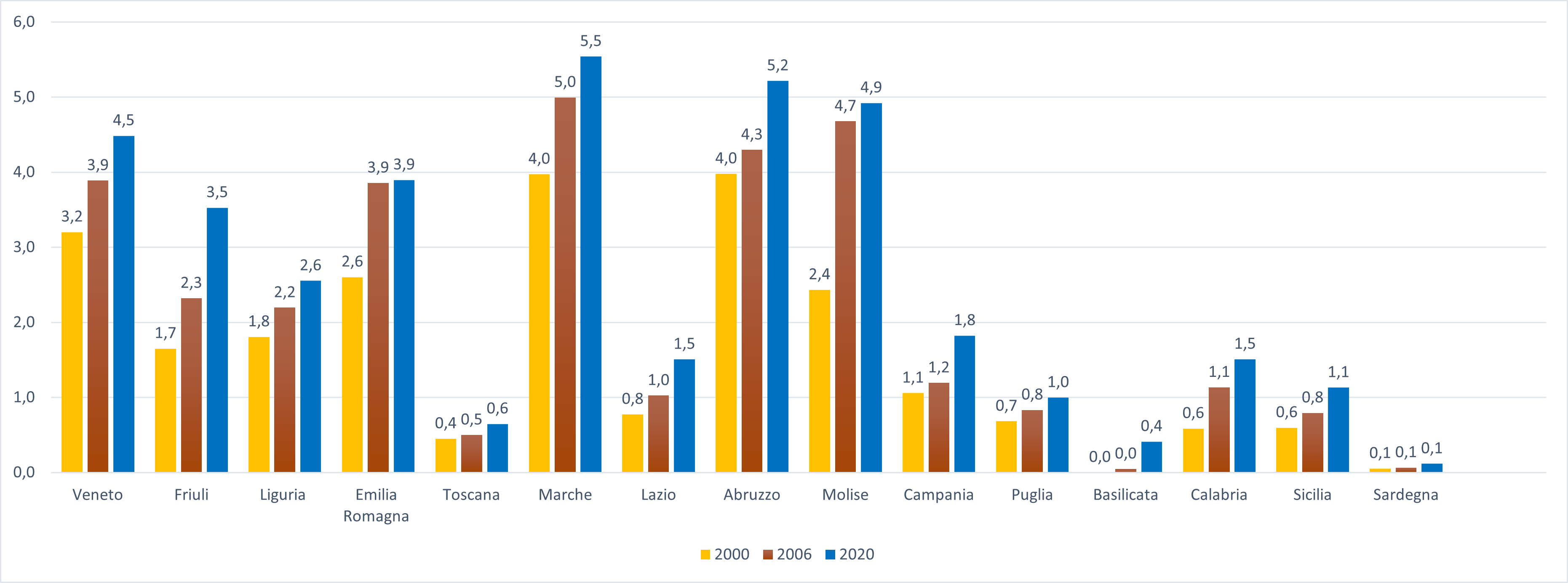
The quantification of rigid defense works of the coasts, built on the national territory, is an indicative parameter both of the invasive action of man on the coastal environment, and of the cost of the defense of infrastructures and assets threatened by the progress of the sea towards the hinterland. In 2020, in Italy, the “rigid” works of coastal defense amount to about 10,500, of which 41% are grazing works. In particular, the regions that show a greater density of coastal defense works per kilometer of coastline are Abruzzo and the Marche, with about 5 defense structures per kilometer of coastline.
From 2000 to 2020, there was an increase in Italy in the construction of rigid coastal defense works (from about 6,600 to 10,500), representative of the fragility of coastal environments subjected to an increasingly increasing anthropogenic pressure (Figure 1). In particular, there is an increase in emergency interventions (wall or thrown-wall roots) for the defense of infrastructure, roads and railways. On the other hand, the increasing adoption of submerged or partially apparent defense interventions (from 10% in 2006 to 16% in 2020) (Figure 5) shows the trend towards the search for a compromise between the hydraulic efficiency of a protection intervention and a lower impact on the environment, in this case, on the landscape and on the circulation of coastal waters.
| Allegati |
|---|
Thumbnail

Headline
Figure 1: Number and trends, from 2000 to 2020, at national level, of rigid coastal defense works divided by type Data source
ISPRA |
Thumbnail

Headline
Figure 2: Distribution at national level, from 2000 to 2020, of rigid coastal defence works divided by type Data source
ISPRA |
Thumbnail

Headline
Figure 3: Trend from 2000 to 2020, at regional level, of the rigid coastal defense works divided by type Data source
ISPRA |
Thumbnail
Headline
Figure 4: Density of rigid defense works per kilometer of regional coast in 2000, 2006 and 2020 Data source
ISPRA |
Thumbnail
Headline
Figure 5: National comparison between the rigid defence works that emerged and submerged in 2006 and 2020 Data source
ISPRA |
Headline
Table 2: Regional coastal data and variations detected in the period 2006-2020 Data source
ISPRA Data legend
The data divided by region represent the total coast (natural + artificial + thittle), natural coast (rock + low sandy), mobile coast (only low sandy) |
In 2020, coastal defence “rigid” works amounted to about 10,500 (Figure 1). In particular, it is noted that in 2006 and 2020 the largest number of defence works consists of grazing works (Figure 2), 35% and 41% respectively of total coastal defence works. These results show that, in the last fifteen years, defense interventions of the coast have increased with an emergency character (wall or thrown-out roots) for the defense of infrastructure, roads and railways. In addition, as shown in Figure 1, all the different types of defense works from 2000 to 2020, with the exception of the “solotti”. The geomorphological characteristics and the exposure of the coasts to the meteomarine phenomena and the intensity of the storms are the elements that have influenced, at the local level, the choice of the type of defense intervention. From the analysis of coastal defence works at regional level (Figure 3), the diversity between the Adriatic, Tyrrhenian regions and the islands emerges, both for the number and for the type of interventions. In particular, it is noted that the medium-Adriatic regions (from Molise to Emilia-Romagna), characterized mainly by sandy and shallow coasts, show an intense concentration of works detached from the shore (scores); the regions of the northern Adriatic (Veneto and Friuli-Venezia Giulia) have deserted lithorias, mainly, with brushes and grazing works, while the Tyrrhenian coasts (Campast). The distribution of the works created for the two largest islands, Sicily and Sardinia, highlights the correlation between geomorphology and the dynamics of the coasts. Sicily, characterized by a low coast for about three quarters of the coast, has a total number of defense works almost ten times higher than Sardinia. Sardinia, characterized mainly by high and rocky coasts, despite having a perimeter equal to a quarter of the entire national coast, has a number of works of defense of the coasts lower than almost all the Adriatic regions. There is also the increasing trend from 2000 to 2020, of all the different types of defense works, with the exception of the Veneto and Emilia-Romagna region, presumably because the rigid works carried out are part of a coastal strip management system that includes planned and monitored periodically. It was considered useful to calculate the density of the defense works per kilometer of regional coast and per year (Figure 4): the Adriatic regions are those with the highest density of works. In particular, in 2020, Abruzzo and Marche reach the peak with 5 coastal defense structures per kilometer of coastline.