Alessandra Galosi
The indicator is calculated for a limited sample of Alpine glaciers and represents the algebraic sum of ice mass gained through snowfall accumulation and mass lost through melting during the ablation period. Glacier mass balance data provide a fundamental measure for assessing the "health status" of glaciers.
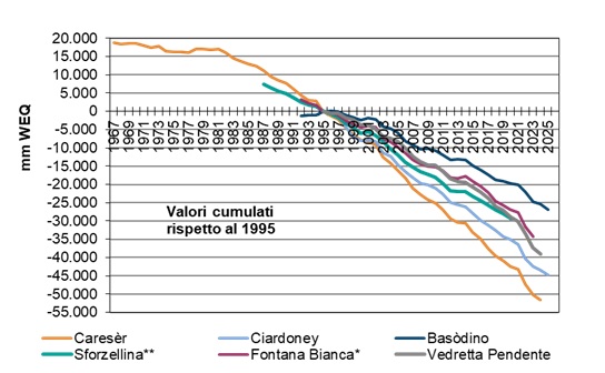
Analysis of data from 1995 to 2023 shows that, for the glaciers considered collectively, the cumulative mass balance exhibits significant losses, ranging from nearly 25 meters water equivalent for the Basòdino glacier to over 50 meters water equivalent for the Caresèr glacier, corresponding to an average annual mass loss exceeding one meter water equivalent.
The indicator, calculated for a limited sample of Alpine glaciers, represents the algebraic sum of the accumulated mass from winter and spring snowfall and the ice mass lost during the melting (ablation) period.
Assess the presence of a trend in the annual mass balances and investigate a possible correlation with changes in climatic conditions in the Alpine region, as an indication of both general climate change and the effects of global change on natural environments.
No references or objectives set by legislation.
NIMBUS, Rivista Italiana di Meteorologia, Clima e Ghiacciai - Società Meteorologica Italiana Onlus (numeri vari).
EEA Report – N 1/2017. Climate change, impacts and vulnerability in Europe 2016 – An indicator-based report.
Østrem, G., & Brugman, M. (1966). Glacier mass balance measurements, Department of Mines and Technical Surveys, Glaciology Section.
Cogley, J. G. (2009). Geodetic and direct mass-balance measurements: comparison and joint analysis. Annals of Glaciology, 50(50), 96-100.
http://www.glaciologia.it/en/i-ghiacciai-italiani/le-campagne-glaciologiche/
Data availability is limited to a small number of glacier sites. For some monitored glaciers (e.g., Sforzellina), mass balance measurements have not been conducted in recent years due to extensive debris cover, which complicates and reduces the reliability of glaciological mass balance assessments on the glacier surface.
An expansion of the number of monitored glaciers, particularly those of significant importance, is desirable.
Italian Glaciological Committee
Trentino Glaciological Committee
SAT (Società degli Alpinisti Tridentini)
Department of Civil, Environmental and Mechanical Engineering – University of Trento
Kappenberger G. – Meteotrentino
Museum of Science – Trento
Autonomous Province of Bolzano – South Tyrol
Italian Meteorological Society
University of Padua
Data request submitted to the monitoring contacts for the various glaciers.
World Glacier Monitoring Service (WGMS) – consultation of the website http://www.wgms.ch/
Italy
1967-2023
For the development of the indicator, seven glacier bodies were considered: in the Western Alps, the Ciardoney Glacier; in the Central Alps, Caresèr Glacier—with the longest historical series dating back to 1967—Basòdino, Sforzellina, and Fontana Bianca Glaciers; and in the Eastern Alps, Dosdè Orientale and Vedretta Pendente Glaciers. These glaciers were selected based on the availability of significant published historical data and mass balance estimation methods performed by qualified operators. Given their different locations along the Alpine arc, these glaciers can be considered representative of distinct climatic sectors.
Data collection requires two measurement campaigns. The accumulation measurement, carried out at the end of the winter season (May–June), aims to quantify snow accumulation by measuring snow depth and density. The second campaign, conducted at the end of summer (September), aims to quantify losses due to snow and ice melt (ablation). Several ablation stakes are installed on the glacier surface; their exposure varies depending on melting or ice thickness increase compared to the previous year. Each stake is considered representative of a specific glacier area.
Over the last decade, various techniques have been employed for estimating glacier melt, including aerial photogrammetry, terrestrial LiDAR, GNSS technologies, and others. The net glacier mass balance is determined by the difference between accumulation and ablation, to which the residual winter snow amount at the end of the ablation season is added.
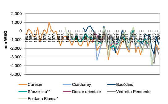
In 2023, glaciers in each of the three Alpine sectors (Western, Central, and Eastern) exhibited retreat: the smaller glaciers at lower elevations are losing their “glacier status,” shrinking to snow and ice accumulations or slightly more. Data available for the 2022–2023 hydrological year on the net mass balance of several glaciers show a negative trend, with all the analyzed Italian glaciers experiencing mass loss (Figure 1).
The glaciers with available historical data from 1995 to 2023, the cumulative mass balance shows significant losses ranging from nearly 25 meters of water equivalent for the Basòdino Glacier to over 50 meters for the Caresèr Glacier, corresponding to an average annual mass loss of more than one meter of water equivalent (Figure 2).
| Allegati |
|---|
Titolo
Table 1: Net mass balance of selected Italian glaciers Fonte
Italian Glaciological Committee, Trentino Glaciological Committee SAT, Meteotrentino, Department of Civil and Environmental Engineering - University of Trento, Museum of Sciences of Trento, Departments of TeSAF and Geosciences - University of Padua (Caresèr); Italian Meteorological Society (Ciardoney); G. Kappenberger (Basòdino); Italian Glaciological Committee (Sforzellina and Eastern Dosdè), Hydrological Office of the Autonomous Province of Bolzano - South Tyrol (Fontana Bianca, Vedretta Pendente) Note
*Since 2018, the mass data for Weißbrunnferner – Fontana Bianca Glacier have been estimated based on measurements from only 3 monitoring stakes (stakes P9, P10, and P16), while in 2022 only 2 stakes were used. **Since 2021/2022, no survey has been conducted to determine the mass balance of the Sforzellina Glacier. The nearly complete debris cover makes the glaciological mass balance assessment on the ground difficult to perform and unreliable. |
Thumbnail
Titolo
Figure 1: Net mass balance Fonte
Italian Glaciological Committee, Trentino Glaciological Committee SAT, Meteotrentino, Department of Civil and Environmental Engineering – University of Trento, Museum of Sciences of Trento, Departments of TeSAF and Geosciences – University of Padua (Caresèr); Italian Meteorological Society (Ciardoney); G. Kappenberger (Basòdino); Italian Glaciological Committee (Sforzellina and Eastern Dosdè); Hydrological Office of the Autonomous Province of Bolzano – South Tyrol (Fontana Bianca, Vedretta Pendente)
Note
*Since 2018, the mass balance data for the Weißbrunnferner – Fontana Bianca Glacier has been estimated based on measurements from only 3 ablation stakes (stakes P9, P10, and P16), while in 2022 only 2 stakes were used. ** Since 2021/2022, no surveys have been conducted to determine the mass balance of the Sforzellina Glacier. The almost complete debris cover makes the glaciological mass balance assessment on the ground difficult to perform and unreliable |
Thumbnail
Titolo
Figure 2: Cumulative mass balance Fonte
Italian Glaciological Committee, Trentino Glaciological Committee SAT, Meteotrentino, Department of Civil and Environmental Engineering, University of Trento, Museum of Science of Trento, Departments of TeSAF and Geosciences, University of Padua (Caresèr); Italian Meteorological Society (Ciardoney); G. Kappenberger (Basòdino); Italian Glaciological Committee (Sforzellina and Dosdè Orientale); Hydrological Office of the Autonomous Province of Bolzano - South Tyrol (Fontana Bianca, Vedretta Pendente)
Note
*Since 2018, the mass data for the Weißbrunnferner – Fontana Bianca Glacier has been estimated based on measurements from only 3 monitoring stakes (stakes P9, P10, and P16), while in 2022 only 2 stakes were used. **Since 2021/2022, mass balance surveys for the Sforzellina Glacier have not been conducted. The nearly complete debris cover makes the glaciological ground balance assessment difficult to perform and unreliable. |
Mass balance data provide a fundamental indication for assessing the “health status” of glaciers. Currently, a limited number of glaciers are monitored in Italy, often with discontinuous or short data series. Consequently, seven glacier bodies have been considered for the indicator calculation: in the Western Alps, the Ciardoney Glacier; in the Central Alps, Caresèr Glacier—with the longest historical series dating back to 1967—Basòdino, Sforzellina, and Fontana Bianca glaciers; and in the Eastern Alps, Dosdè Orientale and Vedretta Pendente glaciers.
These glacier bodies were selected based on the availability of significant published historical data and mass balance monitoring systems operated by qualified personnel. Due to their different locations along the Alpine arc, the various glaciers can be considered representative of distinct climatic sectors.
From the perspective of correlation with climatic trends, although annual mass balance data have high intrinsic value, the glacier response to key climatic drivers (temperature and precipitation) is not always linear. The characteristics of individual glacier basins can influence the annual mass balance differently: for example, in the case of Basòdino, a dominant factor appears to be substantial late-winter snow accumulation, whereas for Ciardoney, the climate–mass balance relationship also seems affected by factors such as the persistence of summer snow cover, the type of winter snow, and variations in the amount of direct solar radiation under similar air temperature conditions.
Overall, this outlines a complex picture where glacier melting results from thermal factors combined with seasonal variations in precipitation distribution and specific climatic conditions (Figure 1).