Panel 1
Stefano Calcaterra, Piera Gambino
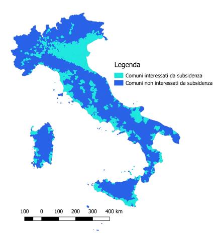
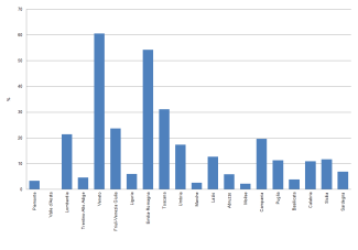
According to the collected data, subsidence affects approximately 18% of Italian municipalities, primarily in Northern Italy, particularly in the Po Valley. In Central and Southern Italy, the phenomenon mainly affects coastal plains. The most affected regions are Veneto and Emilia-Romagna, where over 50% of municipalities experience subsidence.
This indicator identifies the municipalities affected by subsidence, a slow process of ground lowering that primarily affects coastal and lowland areas. It impacts even important historical cities such as Venice and Ravenna. The indicator is based on administrative municipal units and provides a current overview of the phenomenon. Municipalities affected predominantly by sinkhole-related phenomena are excluded, as they are analyzed in a separate indicator.
The aim is to provide a nationwide overview of subsidence and its territorial impact. The causes of subsidence can be natural or anthropogenic, making it a significant environmental risk factor, particularly in densely urbanized or newly urbanized areas and coastal zones, where it exacerbates coastal erosion and seawater intrusion, especially in the context of climate change in the Mediterranean region.
One of the first laws addressing subsidence was Law No. 845 of December 10, 1980, which focused on protecting the territory of Ravenna from the phenomenon by introducing coastal and urban defense measures and restrictions on groundwater resource usage.
At the national level, the key legislative references include:
- Law No. 183/89, which classifies human-induced subsidence as part of hydrogeological instability.
- Legislative Decree 152/2006, addressing environmental protection.
- Ministerial Decree of December 3, 1999 (Art. 2), which established a high-level technical-scientific commission to define and monitor subsidence caused by hydrocarbon extraction.
- Decree Law No. 112 of June 25, 2008 (Art. 8), which prohibits hydrocarbon exploration, research, and extraction in the Venice Gulf until the government, in agreement with Veneto Region, confirms the absence of significant subsidence risks on the coasts.
- Decree Law No. 133 of September 12, 2014, which mandates that mining projects must include scientific studies proving that their activities do not cause subsidence or impact coastal stability, ecosystems, or human settlements.
- EU Directive 96/61/EC (IPPC) on Integrated Pollution Prevention and Control, requiring the assessment of subsidence effects when issuing environmental permits (AIA - Autorizzazione Integrata Ambientale).
This regulatory framework aims to mitigate and prevent the impacts of subsidence on Italian territory.
Panel 2
Proceedings of International Symposium on Land Subsidence;
PanGeo project. Piano Straordinario di Telerilevamento – Geoportale Nazionale.;
Direzione generale per le risorse minerarie ed energetiche del Ministero dello Sviluppo Economico (MiSE) "Indirizzi e linee guida per il monitoraggio della sismicità, delle deformazioni del suolo e delle pressioni di poro nell’ambito delle attività antropiche". –F. Raspini, S. Bianchini, A. Ciampalini, M. Del Soldato, L. Solari, F. Novali, S. Del Conte, A. Rucci, A. Ferretti & N. Casagli; Continuous, semi-automatic monitoring of ground deformation using Sentinel-1 satellites; Scientific Reports • May 2018 DOI: 10.1038/s41598-018-25369-w.;
Arpa Piemonte (2008) – Linee guida all’interpretazione dei dati satellitari PSInSARTM in Piemonte - Vilardo, G., Ventura, G., Terranova, C., Matano, F., and Nardò, S. (2009). Ground deformation due to tectonic, hydrothermal, gravity, hydrogeological, and anthropic processes in the Campania Region (Southern Italy) from Permanent Scatterers Synthetic Aperture Radar Interferometry. Remote Sens. Environ. 113, 197–212. doi: 10.1016/j.rse.2008.09.007;
Indirizzi e linee guida per il monitoraggio della sismicità, delle deformazioni del suolo e delle pressioni di poro nell’ambito delle attività antropiche, Ministero dello sviluppo economico (2014) (https://unmig.mase.gov.it/geomonitoraggi/linee-guida-per-i-monitoraggi/);
Costantini, M., Ferretti, A., Minati, F., Falco, S., Trillo, F., Colombo, D., et al. (2017). Analysis of surface deformations over the whole Italian territory by interferometric processing of ERS, envisat and COSMO-SkyMed radar data. Remote Sens. Environ. 202, 250–275;doi:10.1016/j.rse.2017.07.017;
G. Farolfi, M. Del Soldato, S. Bianchini & N. Casagli (2019): A procedure to use GNSS data to calibrate satellite PSI data for the study of subsidence:an example from the north-western Adriatic coast (Italy), European Journal of Remote Sensing, DOI: 10.1080/22797254.2019.1663710;
M. Polcari, M. Moro, V. Romaniello, S. Stramondo; “Anthropogenic subsidence along railway and road infrastructures in Northern Italy highlighted by Cosmo-SkyMed satellite data” J. Appl. Remote Sens. 13(2), 024515 (2019), DOI: 10.1117/1.JRS.13.024515;
G. Farolfi, S. Bianchini, N. Casagli; Integration of GNSS and Satellite InSAR Data: Derivation of Fine-Scale Vertical Surface Motion Maps of Po Plain, Northern Apennines, and Southern Alps, Italy; September 2018 - IEEE Transactions on Geoscience and Remote Sensing PP(99):1-10, DOI: 10.1109/TGRS.2018.2854371;
L. Tosi, C. Da Lio, T. Strozzi & P. Teatini; Combining L- and X-Band SAR Interferometry to Assess Ground Displacements in Heterogeneous Coastal Environments: The Po River Delta and Venice Lagoon, Italy; Remote Sens. 2016, 8, 308; DOI:10.3390/rs8040308;
G. Herrera-García et al.; Mapping the global threat of land subsidence; Science 371, 34 (2021) DOI: 10.1126/science.abb8549;Solari L, Del Soldato M, Bianchini S, Ciampalini A, Ezquerro P, Montalti R, Raspini F and Moretti S (2018) From ERS 1/2 to Sentinel-1: Subsidence Monitoring in Italy in the Last Two Decades. Front. Earth Sci. 6:149. doi: 10.3389/feart.2018.00149;
EGMS (European Ground Motion Service) https://egms.land.copernicus.eu/;
scientific publications, conference proceedings and technical reports;
documentation available on ISPRA, ARPA/APPA and regional websites.
Currently, the indicator does not provide the actual national extent of the phenomenon or the degree of subsidence in various areas due to inconsistencies in monitoring methods and the complexity of the phenomenon itself. Subsidence is regularly monitored only in certain areas, often using different methodologies, but there is no national catalog. Since subsidence often does not produce significant effects, it is sometimes ignored or underestimated, making it difficult to obtain data on its extent. Additionally, due to the complexity and high cost of data collection, there is considerable inconsistency in the information available across different regions.
A more in-depth study of the phenomenon is needed with the creation of a homogeneous National Scale Catalog reporting the extent of the phenomenon in the various parts of the national territory, its real extension and evolution over time, this will probably be possible in the future also thanks to the use of the products of the Copernicus Mirror Program. For some years now, in some Italian regions, it has been studied using radar-satellite surveys. Recently, the operational ground motion analysis service available on a European scale, European Ground Motion Service (EGMS), developed under the coordination of the European Environment Agency (EEA), has been made available as part of the Copernicus Land Monitoring Project. This service is based on interferometric analysis of Sentinel-1 radar images.
Data quality assessment
ISPRA/ARPA/APPA (Regional and Autonomous Provinces Agencies for the Protection of the Environment)
ARPAE (Arpa Emilia-Romagna)
EEA (European Environmental Agency)
Copernicus Land Monitoring Service (CLMS)
INGV (National Institute of Geophysics and Volcanology)
MASE (Ministry of Environment and Energy Security)
LAMMA Consortium
Autonomous Provinces
Regions
Universities
Research organizations
Used the results of studies and monitoring carried out by Research Institutions, Universities, Regions, ISPRA/ARPA/APPA at various scales and for different purposes. In addition, in some areas, information deducible from the Extraordinary Remote Sensing Plan (http://www.pcn.minambiente.it/mattm/progetto-piano-straordinario-di-telerilevamento/) and European Ground Motion Service (EGMS) was used.
National
2004-2024
Indicator assessment
Collection and statistical analysis of available information.
The subsidence phenomenon affects approximately 18% of Italian municipalities (1,392 municipalities). The most exposed regions are Veneto and Emilia-Romagna, with more than 50% of municipalities impacted. Although instrumental monitoring networks exist in some areas of the country, such as the Po Valley, knowledge of the phenomenon remains partial and inconsistent.
In certain areas, such as Emilia-Romagna and the Venice Lagoon, where fluid extraction from the subsurface is significant, legislative measures adopted to protect the territory have slowed down or even halted subsidence. However, such measures have not been implemented in all affected areas. As a result, the trend of the phenomenon has not yet been accurately and uniformly defined across the national territory. In the future, thanks to the Copernicus Program, it will likely be possible to study the trend of subsidence at a national scale in a more homogeneous manner.
Data
Tabella 1: Comuni interessati da subsidenza
Elaborazione ISPRA su dati raccolti dalla letteratura scientifica, ISPRA/ARPA/APPA e dalle regioni
Aggiornamento a novembre 2024


Subsidence is generally caused by geological factors (sediment compaction, tectonics, isostasy) and typically affects compressible soils. However, in recent decades, it has been locally exacerbated by human activity, sometimes reaching dimensions far greater than those of natural origin.
Natural subsidence is estimated to occur at a rate of a few millimeters per year, meaning its consequences are usually relatively limited and manifest over long periods. However, it can still increase flood risk in alluvial and coastal areas and, in some cases, cause damage to buildings and infrastructure.
On the other hand, induced and/or accelerated subsidence due to human activities (fluid extraction, underground material removal, land reclamation, etc.) can be 10 to over 100 times faster, with effects that can manifest in a short period, sometimes compromising affected structures.
The interaction between natural and anthropogenic processes makes studying and mitigating subsidence complex. Quantifying and analyzing its temporal evolution through specific monitoring investigations is crucial. These studies use various methodologies, including high-precision geometric leveling, GNSS networks, and differential interferometric techniques, which have been employed for several years by regional agencies, provinces, municipalities, research institutions, universities, ISPRA, and ARPA/APPA.
The subsidence phenomenon affects about 18% of Italian municipalities (1,392 municipalities) (Table 1). Most affected municipalities are in Northern Italy, particularly in the Po Valley. In Central and Southern Italy, the phenomenon mainly impacts coastal plains.
The most affected regions include:
In some areas, regional monitoring systems allow for evaluating the phenomenon’s trend over time. For example, Emilia-Romagna has been systematically monitoring subsidence for decades. The region has accumulated a vast dataset of on-site measurements (geometric leveling and GPS), supplemented in recent years by satellite radar interferometry.
Monitoring by ARPA Emilia-Romagna has shown a significant reduction in subsidence over the past decade due to the increased use of surface water for drinking purposes, leading to a reduction in groundwater withdrawals.
In other regions such as Campania, Veneto, Tuscany, Lombardy, and Piedmont, satellite radar interferometry is also used to study subsidence, but monitoring is not conducted regularly. Currently, Emilia-Romagna is the only region that regularly produces iso-subsidence and iso-variation maps.