MAIN LANDSLIDE EVENTS
Data aggiornamento scheda:
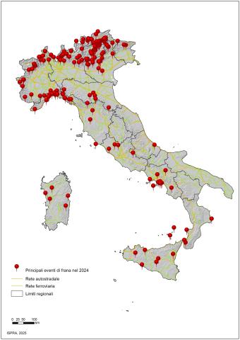
The indicator provides information on the main landslide events that caused fatalities, injuries, evacuations, and damage to buildings, cultural heritage assets, primary linear communication infrastructures, and service networks across the national territory over the past year. In 2024, there were 185 major landslide events, resulting in 5 deaths, 18 injuries, and predominantly causing damage to the road network and buildings.
URGENT MEASURES FOR THE REDUCTION OF HYDROGEOLOGICAL RISK
Data aggiornamento scheda:
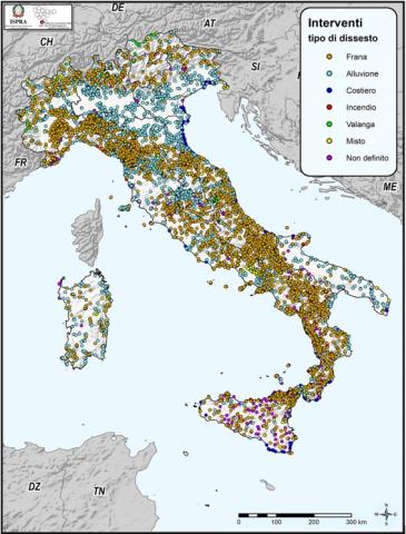
Monitoring of landslide and flood-risk mitigation measures funded since 1999 by the various State Administrations across the national territory is carried out by ISPRA through the ReNDiS platform (National Registry of Interventions for Soil Protection). As of 31 December 2024, the platform records a total of 25,921 interventions, corresponding to a total allocation of €20.559 billion. Of these, the interventions under the remit of the Ministry of the Environment and Energy Security (MASE) account for 26.9% (6,983) of the total, with related funding amounting to about 43% (€8.850 billion) of all public resources allocated by other Administrations (extra-MASE). These include the Ministry of the Interior, the Civil Protection Department, the Casa Italia Department of the Presidency of the Council of Ministers, the Ministry of Agriculture, Food Sovereignty and Forests (MASAF), and the Regions of Calabria and Lombardy. Extra-MASE interventions represent roughly 73% (18,938) of the total number of projects, corresponding to nearly 57% (€11.708 billion) of total funding.
As regards implementation status, 9,350 interventions — around 36% — have been completed; 11% (2,937) are under construction; 19% (4,833) are in the design phase; and nearly 33% (8,509) have not yet started or lack reported data. The indicator also details how expenditure is distributed by type of hazard. Finally, the dataset includes information on funding requests submitted by Regions/Autonomous Provinces to MASE and the Casa Italia Department for new mitigation measures, consisting of 555 requests deemed eligible for funding under the DPCM of 27 September 2021, for a total project cost of approximately €1.678 billion
ITALIAN LANDSLIDE INVENTORY (IFFI)
Data aggiornamento scheda:
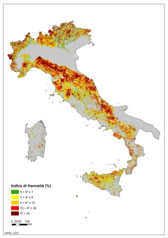
The indicator provides information on the number and distribution of landslides in Italy. More than 636,000 landslides have been recorded (reference period 1116–2025), affecting an area of over 25,100 km², equivalent to 8.3% of the national territory.
POPULATION EXPOSED TO LANDSLIDES
Data aggiornamento scheda:
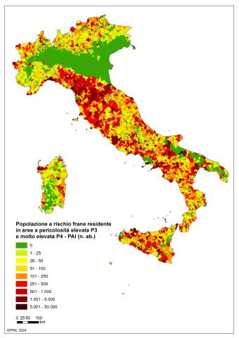
The indicator provides an estimate of the population at risk of landslides (risk of personal injury: dead, missing, injured, evacuated) on a national, regional, provincial and municipal basis. In Italy, the population at risk of landslides residing in areas with high and very high PAI danger (P3+P4) amounts to 1,284,960 inhabitants, equal to 2.2% of the total.
CULTURAL HERITAGE EXPOSED TO LANDSLIDES AND FLOODS
Data aggiornamento scheda:
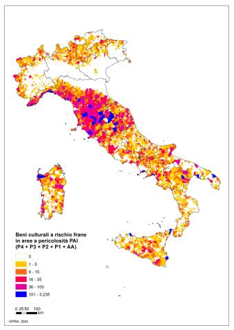
The indicator provides information relating to cultural heritage at hydrogeological risk on the national territory. There are 45,339 cultural assets at risk of landslides, of which 13,966 are located in areas with high P3 and very high P4 danger. The cultural assets at risk of flooding are 35,997 in the medium hydraulic danger scenario (return times between 100 and 200 years) and reach 54,103 in the low hydraulic danger scenario, which is the maximum expected scenario.
LANDSLIDE HAZARD AREAS
Data aggiornamento scheda:
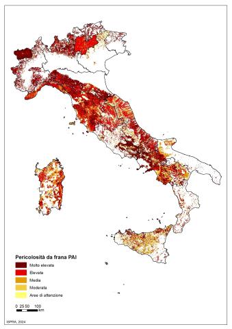
The indicator provides information on the landslide-prone areas of the Hydrogeological Management Plans (PAI) on the national territory. The total surface area, in Italy, of the PAI landslide hazard areas and the areas of attention is equal to 69,530 km 2 (23% of the national territory), of which 28,801 km 2 (9.5%) are areas of high P3 and very high P4 danger, subject to the most restrictive land use constraints.