Gianluigi Di Paola, Carla Iadanza, Alessandro Trigila
The indicator provides information on the number and distribution of landslides in Italy. More than 636,000 landslides have been recorded (reference period 1116–2025), affecting an area of over 25,100 km², equivalent to 8.3% of the national territory.
The indicator provides information on the number and distribution of landslides in Italy based on the data contained in the Inventory of Landslide Phenomena in Italy - IFFI. The Inventory is created by ISPRA, by the regions and autonomous provinces and by the ARPA competent in the matter; ISPRA has the function of directing, coordinating and controlling activities, managing the database, producing national calculations and statistics, and disseminating data; the regions and autonomous provinces have the fundamental role of collecting, archiving, computerizing and validating data on landslides. Italy is the European country most affected by landslides, with 2/3 of the landslides recorded in Europe (2015 EuroGeoSurveys survey). Landslides are extremely widespread due to the geological and morphological characteristics of the Italian territory, which is 75% mountainous and hilly. The Inventory of Landslide Phenomena in Italy aims to identify and map landslides on Italian territory according to standardized and shared methods. The IFFI database contains cartography, alphanumeric parameters and any photos, videos and documents associated with landslides and landslide events. A landslide is a movement of a mass of rock, earth or debris along a slope and is therefore representative of a phenomenon in a specific portion of territory. A landslide event represents a specific moment in time (activation/reactivation) of a landslide; multiple events can therefore be associated with a landslide. IFFI landslides are registered by completing the Landslide Form and represented by a point (Identification Point of the Landslide Phenomenon - PIFF) located at the crown of the landslide, by a polygon when the surface can be mapped at the survey scale adopted or by a line, when the width of the landslide cannot be mapped (e. g. Rapid flows). Each landslide is uniquely identified throughout the national territory through an identification code (ID-Landslide). Landslide events are recorded by completing the Event Sheet which contains a selection of the fields of the Landslide Sheet and a smaller number of mandatory fields. The geometry can be represented with just a point or even with a polygon regardless of the size of the landslide. If the event is represented exclusively with the dot, the latter can be located in correspondence with the crown, the nail or in another "n. d." position. (e. g. Damaged building or road) with different position accuracy values: exact, < 100 m, < 1,000 m, < 10,000 m. The Event Card can be used to collect data quickly, especially in emergencies; it can be used for the census of a landslide event, both in the case of a newly formed phenomenon and a reactivation of an existing IFFI landslide. The Inventory of Landslide Phenomena in Italy represents a useful basic cognitive tool for the assessment of landslide danger, for territorial planning and for the programming of hydrogeological risk mitigation interventions.
Provide an overview of the number and distribution of landslides on the national territory.
Creation of the inventory map of landslide phenomena in Italy (Resolution of the Committee of Ministers for Technical Services and interventions in the soil protection sector, 17/01/1997).
Collection, processing, archiving and dissemination of data regarding soil protection and hydrogeological instability referring to the entire national territory (art. 55 of Legislative Decree 152/2006 “Regulations on environmental matters”).
Update of the Inventory of Landslide Phenomena in Italy (art. 6, paragraph 1 letter g of Law 132/2016).
Trigila A., Iadanza C., Romeo S., Di Paola G., Gambino P., Calcaterra S., Zastrow L. R., Romano D., Biondo T., Noman M., Di Muro F., Dragoni A. (2025) Advancing landslide knowledge and dissemination in Italy through IdroGEO 2.0 web platform. Landslides 2025. https://doi. org/10.1007/s10346-025-02592-x
ISPRA - Trigila A., Lastoria B., Iadanza C., Bussettini M., Mariani S., D'Ascola F., Salmeri A., Cassese M. L., Pesarino V., Di Paola G., Romeo S., Rischia I., Dessì B., Spizzichino D., Licata V., Gallozzi P. L. (2025) Hydrogeological instability in Italy: hazards and risk indicators - 2024 Edition. Reports 415/2025.
Iadanza C., Trigila A., Starace P., Dragoni A., Roccisano M., Biondo T. (2021), IdroGEO: A Collaborative Web Mapping Application Based on REST API Services and Open Data on Landslides and Floods in Italy. ISPRS International Journal of Geo-Information. 2021; 10(2):89. Https://doi. org/10.3390/ijgi10020089.
ISPRA - Trigila A., Iadanza C. (2008), Landslides in Italy – Special report 2008 (Reports 83/2008).
APAT - Trigila A. (2007), Report on landslides in Italy - The IFFI Project: methodology, results and regional reports (Reports 78/2007).
-
Refinancing of the IFFI Inventory for the updating and integration of the national database.
ISPRA
Inventory of Landslide Phenomena in Italy - ISPRA: https://idrogeo. isprambiente. it
National, regional, provincial, municipal
1116-2025
The indicator is obtained through statistical analysis and GIS processing of the Inventory of Landslide Phenomena in Italy. The data are represented with different indices: number of landslides, number of landslide events, area affected by landslide phenomena, landslide density (number of landslide phenomena/events per square kilometre), landslide index (surface area affected by landslides/total surface area), percentage distribution of movement types.
Italy is the European country most heavily affected by landslides, with more than 636,000 recorded events, accounting for roughly two-thirds of all mapped landslides in Europe.
The temporal coverage of the Inventory spans 1116–2025, corresponding to the dates of activation of the oldest and most recent landslides included. However, a meaningful time series of parameters is not available for a sufficient number of landslides, since the activation date—which would allow trend analysis—is known for a very limited share of the Inventory (less than 5% of the total).
| Allegati |
|---|
Titolo
Table 1: Main parameters - Inventory of Landslide Phenomena in Italy (IFFI) Fonte
ISPRA |
Thumbnail
Titolo
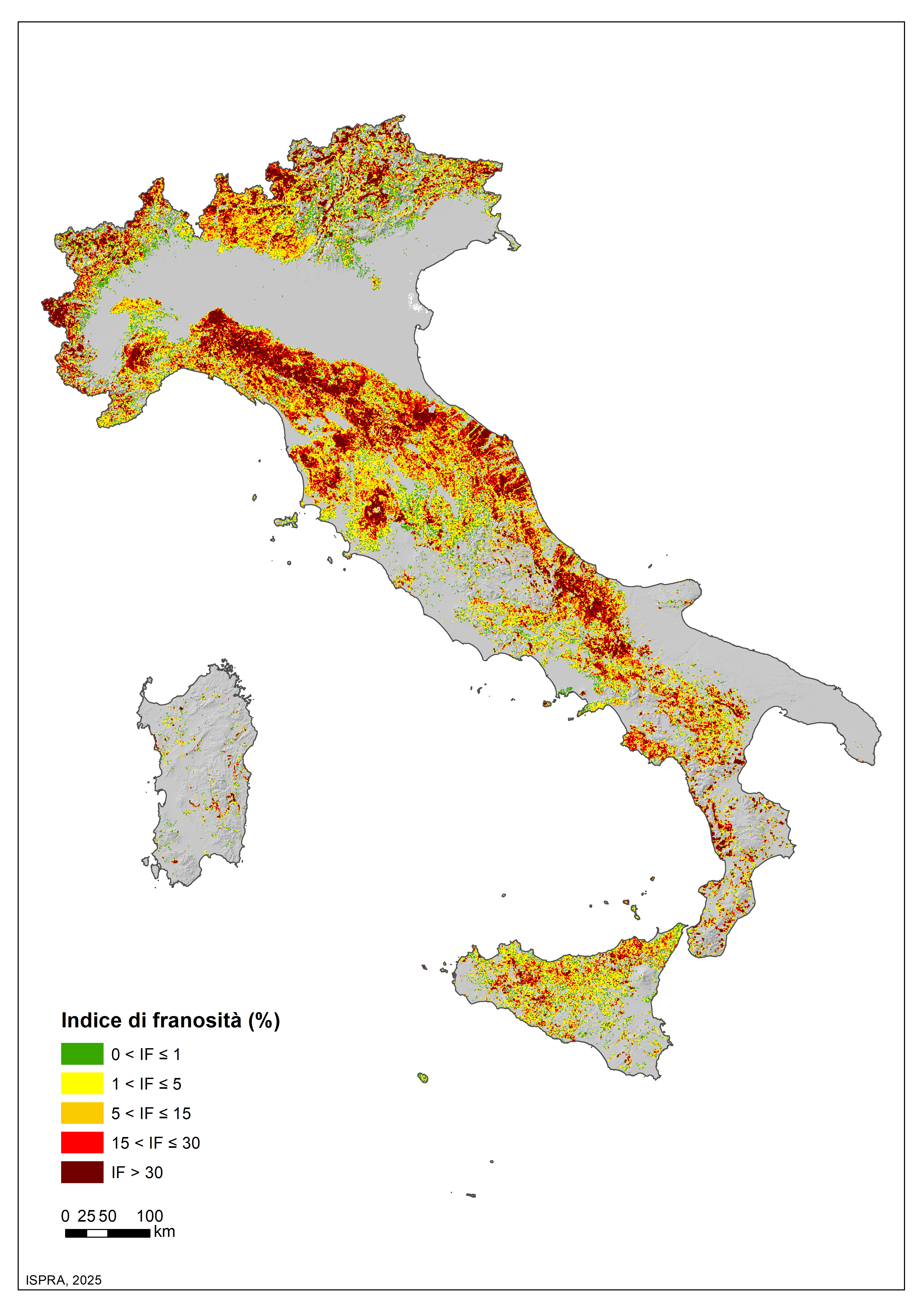
Figure 1: Landslide index for the national territory (%) Fonte
ISPRA |
Thumbnail

Titolo
Figure 2: Percentage distribution of movement types Fonte
ISPRA |
The landslides recorded in the Italian Landslide Inventory amount to 636,496 and affect an area of 25,138 km², equal to 8.3% of the national territory (data updated to 16 October 2025). The survey of landslides for the IFFI Inventory was launched by ISPRA and the regions and autonomous provinces in 1999. An overview of the spatial distribution of landslides in Italy can be derived from the landslide index, defined as the ratio between landslide area and total area, calculated on a 1-km grid (Figure 1). The mountain–hill landslide index (Table 1), which expresses the incidence of landsliding on the portion of regional territory potentially affected by slope instability, was calculated using both the landslide area and the simplified Orographic Model of Italy (Landslides in Italy Report, APAT Reports 78/2007).
The variation in the number of landslides compared with previous updates of the Yearbook Database mainly reflects the ongoing revision and integration of landslide information in the Inventory through more detailed studies, and only partly the identification of new landslides within the year. Landslide data are updated to 2025 for the Autonomous Province of Bolzano; to 2024 for Veneto, Sicily and Sardinia; to 2022 for Piedmont; to 2021 for Tuscany; to 2018 for Umbria; to 2017 for Emilia-Romagna, Friuli Venezia Giulia, Liguria and Valle d'Aosta; and to 2014 for Basilicata and Lombardy. For the remaining regions, data are updated to 2007.
ISPRA has nonetheless continued to record major landslide events at the national scale, in collaboration with regions and autonomous provinces. These are events causing fatalities, injuries, evacuations and damage to buildings, cultural assets, major linear communication infrastructures and service networks (see the indicator “Major landslide events” – Environmental Indicators Database). The major landslide events recorded nationally in 2024 were 185.
The most frequent types of movement—classified based on the dominant mechanism—are rotational/translational slides (35.1%), slow flows (12.8%), rapid flows (13%), complex landslides (9.4%) and areas with diffuse rockfalls/topples (9.4%) (Figure 2). Many landslides experience repeated reactivations over time; periods of multi-year or even multi-century dormancy often alternate with phases of renewed activity triggered by intense rainfall events. Short-duration intense precipitation and prolonged rainfall are the main factors responsible for slope instability. Human factors are playing an increasingly significant role among the predisposing causes, through both direct actions—such as road cuts, excavations, and loads from buildings or road/railway embankments—and indirect actions, such as inadequate land management and insufficient maintenance of soil-protection works.