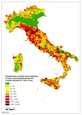
Panel 1
Carla Iadanza, Alessandro Trigila
The indicator provides an estimate of the population at risk of landslides (risk of personal injury: dead, missing, injured, evacuated) on a national, regional, provincial and municipal basis. In Italy, the population at risk of landslides residing in areas with high and very high PAI danger (P3+P4) amounts to 1,284,960 inhabitants, equal to 2.2% of the total.
The indicator provides information on the population at risk of landslides. By population exposed to landslides we mean the resident population exposed to the risk of personal injury (dead, missing, injured, evacuated). The estimate was carried out using as input data the ISPRA national Mosaicing (v. 5.0 – 2024) of the landslide hazard areas (very high P4, high P3, medium P2, moderate P1 and AA attention areas), delimited in the Hydrogeological Management Plans (PAI) drawn up by the District Basin Authorities (formerly the Basin Authority) and the Autonomous Provinces of Trento and Bolzano; the ISTAT permanent population census (2021) and the ISTAT administrative limits (2024).
Provide an estimate of the population at risk of landslides on a national, regional, provincial and municipal basis.
Collection, processing, archiving and dissemination of data regarding soil protection and hydrogeological instability referring to the entire national territory (art. 55 of Legislative Decree 152/2006 “Regulations on environmental matters”); D. L. 180/98 “Sarno Decree” converted into Law 267/1998, Prime Ministerial Decree of 09/29/98 (Guidance and coordination act), L. 365/00;
Result indicator in the context of the 2014-2020 Partnership Agreement between Italy and the European Commission (Thematic Objective 5 - Promote adaptation to climate change, prevention and risk management); Indicator used for the distribution of funds between the Regions (DPCM 5 December 2016) as part of the National Plan against hydrogeological instability.
Panel 2
Trigila A., Lastoria B., Iadanza C., Bussettini M., Mariani S., D'Ascola F., Salmeri A., Cassese M. L., Pesarino V., Di Paola G., Romeo S., Rischia I., Dessì B., Spizzichino D., Licata V., Gallozzi P. L. (2025) Hydrogeological instability in Italy: hazards and risk indicators - 2024 Edition. ISPRA, Reports 415/2025
-
-
Data quality assessment
The ISTAT Census 2021 is available at the link: https://www. istat. it/it/archivio/104317
The ISPRA national landslide hazard mosaic is published on the IdroGEO Platform: https://idrogeo. isprambiente. it/.
National, Regional, Provincial, Municipal
2024
Indicator assessment
The estimate of the population at risk was carried out by intersecting, in a GIS environment, the ISPRA mosaic of the PAI landslide hazard areas with the 756,259 sections of the ISTAT 2021 Census. Since the exact location of the population within the sections is not known, the inhabitants were uniformly distributed within each section. The number of exposed people was then calculated with the proportionality method, multiplying the percentage of area at risk from landslides within each census section by the population residing in the aforementioned section.
The vulnerability, which represents the degree of loss of the element at risk that can be damaged during an event, was conservatively set equal to 1, as its evaluation would require knowledge of the magnitude of the landslide phenomena (speed and volume) as well as knowledge of the behavior/resilience of the population categories (e. g. Elderly, children, non-self-sufficient people). Vulnerability can also vary based on the time of year (summer/winter), the day of the week (weekdays/holidays) and the time (daytime/nighttime) in which the event occurs.
In Italy, the population at risk of landslides residing in areas with high and very high PAI danger (P3+P4) amounts to 1,284,960 inhabitants, equal to 2.2% of the total.
At present, a trend of the indicator cannot be assessed due to the limitations of the historical series available (2015, 2018, 2021, 2024).
Data
Table 1: Population at risk of landslides on a regional basis – 2024
ISPRA
* Resident population (2021 ISTAT census) aggregated on ISTAT 2024 regional administrative boundaries
Table 2: Population at risk of landslides on a provincial basis – 2024
ISPRA
* Resident population (ISTAT 2021 Census) aggregated according to ISTAT 2024 provincial administrative boundaries


The population at risk of landslides in Italy is equal to: 477,054 inhabitants living in very high danger areas P4 PAI; 807,906 inhabitants living in high danger areas P3; 1,711,206 inhabitants in medium danger areas P2; 2,014,125 inhabitants in moderate danger areas P1 and 697,978 inhabitants in areas of caution. If we consider the two most dangerous classes (P3+P4), the population at risk amounts to 1,284,960 inhabitants, equal to 2.2% of the total (Figure 1); while if all classes are taken into account the population at risk reaches 5,708,269 inhabitants (9.7%). The regions with higher values of population at risk of landslides residing in PAI areas with P3 and P4 danger are Campania, Tuscany, Liguria, Sicily, Lazio and Emilia-Romagna (Table 1).
The municipalities falling into the first class (number of inhabitants at risk equal to 0) could have non-zero risk for the population, due to the possible presence of inhabitants residing in areas classified as less dangerous.
Comparing the data from the 2021 and 2024 calculations, the population at risk of landslides, residing in high and very high danger areas, decreased by 1.4% compared to an increase in surfaces classified as P3 and P4 danger of 9.2%. Given that in the 2024 processing the 2021 Istat population census was used as input data (756,259 census sections and total resident population equal to 59,030,133 inhabitants), with a decrease in the resident population of 0.7% compared to the 2011 census (402,678 census sections and resident population of 59,433,744 inhabitants), the decoupling between the 2021-2024 change in the population at risk and in the surfaces classified as highly dangerous P3 and very high dangerous P4 is influenced by the decrease in the resident population, especially in the internal areas, which are mainly located along the Alpine and Apennine ridge and therefore more affected by areas at risk from landslides.