Aree
ENVIRONMENTALLY BENEFICIAL SUBSIDIES AND ENVIRONMENTALLY HARMFUL SUBSIDIES
Data aggiornamento scheda:
In 2024, the seventh edition of the Catalogue of Environmentally Harmful and Environmentally Beneficial Subsidies identified a total of 191 subsidy measures (compared with 183 in 2022). These included EUR 25.4 billion in Environmentally Harmful Subsidies (EHS), a record EUR 71.8 billion in Environmentally Beneficial Subsidies (EBS), and EUR 26.3 billion in Uncertain Environmental Impact Subsidies (UEIS). Among environmentally harmful subsidies, those supporting fossil fuels amounted to EUR 19.6 billion in 2024.
REGIONAL AIR QUALITY IMPROVEMENT PLANS
Data aggiornamento scheda:
The indicator is based on information on air quality plans which, under Directive 2008/50/EC (as transposed into Italian legislation by Legislative Decree No 155/2010), must be adopted where the limit values for the main air pollutants are exceeded.
At the national level, the Regions and Autonomous Provinces report information on air quality plans to ISPRA using the reporting format established by Commission Implementing Decision 2011/850/EU. ISPRA collects and stores these data in the InfoAria database. The information is then transmitted to the European Commission "within two years of the end of the year in which the first exceedance was observed" (Directive 2008/50/EC, Article 23).
Information on air quality plans is therefore not reported annually, but only when new information becomes available. Consequently, the analysis includes both the information reported in 2025 and the information submitted in previous years by Regions and Autonomous Provinces that were not required to submit an updated report.
The analysis shows that the measures reported in 2025, adopted following exceedances of the limit values recorded in 2023, together with those reported in previous years and still in force, amount to 551. Of these measures, 48% relate to the road transport sector and 18% to the residential and commercial sector.
LABORATORY PERFORMANCE INDEX
Data aggiornamento scheda:
With regard to air quality, interlaboratory comparisons are carried out in compliance with Article 17 of Legislative Decree No. 155 of 13 August 2010, implementing Directive 2008/50/EC. This regulatory framework was subsequently amended by Legislative Decree No. 250/2012 and by Ministerial Decree of 26 January 2017 transposing Directive (EU) 2015/1480, which requires institutions responsible for the management of monitoring networks to participate in national quality assurance programmes organised by ISPRA, pursuant to Ministerial Decree of 4 February 2022, No. 67, which designates ISPRA as the National Reference Laboratory for air quality.
Participation of a laboratory in performance evaluation exercises through interlaboratory comparisons represents an operational tool within quality assurance and quality control (QA/QC) activities, supporting the demonstration of competence in the application of the measurement methods in use. The quality of laboratories’ analytical performance is assessed in terms of compliance or non-compliance with acceptability criteria established a priori by technical standards or, in some cases, by more stringent, purpose-oriented criteria adopted by the European Commission in comparable studies.
With reference to air quality monitoring measurements, comparison of performance between 2023 and 2025 does not indicate any substantial variations. The proportion of laboratories achieving acceptable evaluations is approximately 90% (91% and 88.4%, respectively). The total number of evaluations increased from 5,141 in 2023 to 11,187 in 2025.
STATE OF IMPLEMENTATION OF THE OPTIMAL TERRITORIAL AREA PLANS
Data aggiornamento scheda:
The Area Plans (PdA) in the context of water resources management represent a tool for planning and scheduling the activities of the Integrated Water System (SII) or public services for the collection, supply and distribution of water for civil uses, sewerage and waste water purification. The indicator provides on a national scale a picture of the Area Plans currently in force in the Optimized Territorial Areas (ATO) into which the territory is divided in implementation of the current legislation. Currently the national territory is divided into 62 ATOs delimited by the regions on the basis of rules contained in the Environmental Code (Legislative Decree 3 April 2006, n. 152, Part III). 57 of the 62 ATOs are equipped with a PdA (although not recently approved).
STATE OF PROGRESS OF THE MANAGEMENT PLANS OF THE RIVER DISTRICTS
Data aggiornamento scheda:
The Water Framework Directive 2000/60/EC (WFD) provides for the review and updating of river basin management plans (PdG) within 15 years of the entry into force of the directive itself and, subsequently, every six years (art. 13). Therefore, in implementation of this indication, in order to develop the planning cycle relating to the period 2015-2021, the review and update of the first Plans adopted in 2010 was started in 2012. The process concluded with the approval of the plans between March and June 2016. Subsequently, the preparation of the second update of the Plans began, as required by the art. 117 paragraph 2bis of Legislative Decree 152/2006. The update concluded in December 2021 with the adoption of the PdG (for all the river basin districts) by the Permanent Institutional Conference. The Water Protection Plans (PTA) are the plans through which the regions, on the basis of the objectives set at the hydrographic district scale by the Master Plans, define the interventions aimed at guaranteeing the achievement or maintenance of the quality objectives of the water bodies and the measures necessary for their qualitative and quantitative protection at a regional level. As of October 2025, six regions and the autonomous provinces of Trento and Bolzano have an updated PTA based on the 2021 PdGs. Another six regions have a PTA adopted or approved after the publication of the 2015 PdGs. The remaining regions (seven) have a PTA dating back to a period prior to the publication of the 2015 PdGs.
Between 2024 and 2025, three regions updated the PTA to align it with the latest management cycle of the 2021 PdG (Lazio, Valle d'Aosta and Basilicata).
STATUS OF APPROVAL OF MUNICIPAL ACOUSTIC ACOUSTIC PLANS
Data aggiornamento scheda:
The municipal noise abatement plan is envisaged by the legislation as a fundamental tool for managing and resolving noise pollution problems in the area; this Plan represents the act consequent to the main fulfillment by the municipalities: the acoustic classification plan. The redevelopment plan must be coordinated with all the other tools provided for the management of the municipal territory and must incorporate the contents of the transport infrastructure noise containment and abatement plans. As of 2024, this planning tool is poorly used across the entire national territory: only 66 municipalities of the 5,106 with acoustic classification have approved the Noise Remediation Plan, confirming a percentage of just over 1% over the years.
STATUS OF IMPLEMENTATION OF MUNICIPAL NOISE ZONING PLANS
Data aggiornamento scheda:
The Noise Classification Plan represents the main municipal planning act for the management of noise pollution. The Plan consists in the division of the municipal territory into acoustically homogeneous areas, to which acoustic limits are associated, with the aim of providing an indispensable tool for planning urban development and protecting the territory from noise pollution.
By 2024, on the national territory, the Acoustic Classification Plan has been approved in 65% of municipalities; the differences in the application of this planning tool are still evident at a regional scale.
STATUS OF IMPLEMENTATION OF THE ACOUSTIC CHARACTERIZATION OF THE AIRPORT AREA
Data aggiornamento scheda:
The management of noise pollution produced by airport infrastructures is carried out through the implementation of the obligations required by current legislation, in particular the approval of the acoustic characterization of the airport surroundings, an act of planning of the territory surrounding the airport which allows its use to be regulated in a manner compatible with the sound levels produced by the infrastructure, the application of specific anti-noise procedures, in order to minimize the acoustic impact produced by aircraft, and the implementation and management of an airport noise monitoring system. To date, these requirements are still disregarded in many airports across the country. By 2025, in 25 of the 42 airports where national and international air traffic is present, 39 of which have been identified by ENAC as "airports of national interest", the acoustic characterization of the airport surroundings has been approved, a fundamental and priority act for managing noise pollution.
URGENT MEASURES FOR THE REDUCTION OF HYDROGEOLOGICAL RISK
Data aggiornamento scheda:
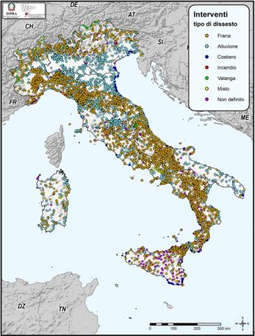
Monitoring of landslide and flood-risk mitigation measures funded since 1999 by the various State Administrations across the national territory is carried out by ISPRA through the ReNDiS platform (National Registry of Interventions for Soil Protection). As of 31 December 2024, the platform records a total of 25,921 interventions, corresponding to a total allocation of €20.559 billion. Of these, the interventions under the remit of the Ministry of the Environment and Energy Security (MASE) account for 26.9% (6,983) of the total, with related funding amounting to about 43% (€8.850 billion) of all public resources allocated by other Administrations (extra-MASE). These include the Ministry of the Interior, the Civil Protection Department, the Casa Italia Department of the Presidency of the Council of Ministers, the Ministry of Agriculture, Food Sovereignty and Forests (MASAF), and the Regions of Calabria and Lombardy. Extra-MASE interventions represent roughly 73% (18,938) of the total number of projects, corresponding to nearly 57% (€11.708 billion) of total funding.
As regards implementation status, 9,350 interventions — around 36% — have been completed; 11% (2,937) are under construction; 19% (4,833) are in the design phase; and nearly 33% (8,509) have not yet started or lack reported data. The indicator also details how expenditure is distributed by type of hazard. Finally, the dataset includes information on funding requests submitted by Regions/Autonomous Provinces to MASE and the Casa Italia Department for new mitigation measures, consisting of 555 requests deemed eligible for funding under the DPCM of 27 September 2021, for a total project cost of approximately €1.678 billion
PLANS WITH APPLICATION OF THE SEA AT REGIONAL LEVEL
Data aggiornamento scheda:
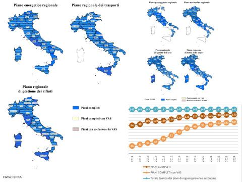
The indicator provides an overview of the regional planning in force relating to seven types of plan and the state of application of the related Strategic Environmental Assessment (SEA) processes. As of December 31, 2024, 130 floors have been completed out of a total of 147 planned floors, for a coverage of 88%. In the same period, the total number of complete plans in force with SEA rose to 105, which represents 71% of all complete plans envisaged (147) and 81% of the plans currently complete (130).
REGIONAL COASTAL MANAGEMENT PLANS
Data aggiornamento scheda:
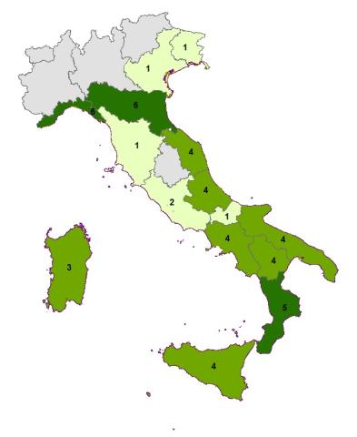
The indicator is the result of the regional recognition of the state of planning relative to the coastal strip. 11 coastal regions out of 15 have regional planning tools extended to the management and protection of the coastal territory and some are preparing a second regional plan, distinguishing with greater clarity that intended for the protection and protection of the coasts from that oriented to the development and coordination of socio-economic activities.
The analysis of the indicator shows in recent years an overall acceleration of the planning processes and, although not measurable by the indicator, numerous initiatives to update and refine the tools already adopted. The reason for this increased activity is believed to be partly linked to the growing sensitivity to the erosion problem, and partly to depend on the introduction into the basin planning of the Flood Risk Management Plan, which requires the assessment of danger and risk for coastal flooding.
IMPLEMENTATION STATUS OF PLANNING IN NATIONAL PARKS
Data aggiornamento scheda:
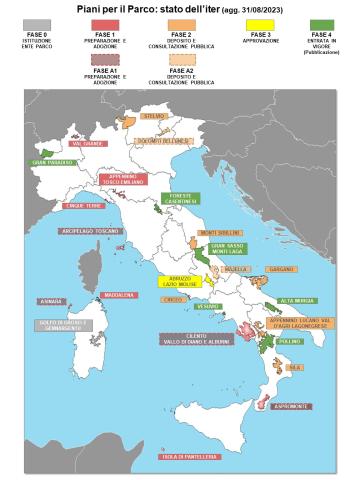
The indicator, referring to the 25 National Parks established as of 08/31/2023, represents the implementation status of Park Plans under Article 12 of Law 394/1991 within the complex process of drafting - adoption - approval by the competent authorities. Compared to 2020, the number of active plans has increased by one unit (Pollino National Park), reaching a total of 12. However, a general delay persists, particularly regarding plans pending approval. Considering the legal timeframe for the entry into force of a Park Plan, all National Parks (NPs) should have had an active plan by now. Instead, an average delay of 21 years in the approval process has been recorded.
SEISMIC CLASSIFICATION AND SEISMIC MICROZONATION
Data aggiornamento scheda:
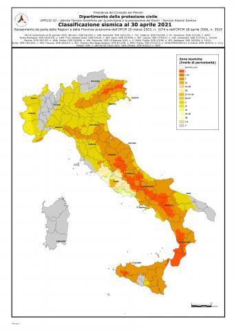
This indicator focuses on the evolution of seismic classification and seismic regulations in Italy, with particular reference to seismic microzonation (MS). Regarding seismic classification, although it has not been the regulatory reference for seismic design since 2006—where reference is now made directly to the Technical Standards for Construction (Ministerial Decree of January 17, 2018)—it continues to serve as a reference for technical and administrative controls. The latest update provided by the Civil Protection Department, as of April 2021, classifies the territory into four main classes and sixteen subclasses, based on proposals from each region for its municipalities.
Regarding regulations governing seismic microzonation studies, the Civil Protection Department, in collaboration with the Conference of Regions and Autonomous Provinces, defined general guidelines and criteria in 2008. In subsequent years, some regions issued specific technical regulations adapting the general guidelines to their territories based on their particular vulnerabilities, concerning seismic amplification issues and, in some cases, surface fault rupture hazards. The seismic sequence that affected Central Italy starting on August 24, 2016, spurred the implementation of Level III seismic microzonation studies in all 140 affected municipalities. These studies were validated by a working group established by the Special Commissioner for Reconstruction in Central Italy. Various in-depth studies on active and capable faults within the Level III microzonation framework are ongoing and are expected to be completed by the end of 2021.
CLIMATE CHANGE ADAPTATION STRATEGIES AND PLANS
Data aggiornamento scheda:
Regional Climate Change Adaptation Strategies and Plans are the primary tools available to regional authorities to address the impacts of climate change and implement actions aimed at reducing territorial vulnerabilities. In Italy, the number of adopted regional strategies and plans remains very limited. Despite the absence of a binding regulatory framework and a national programmatic reference context, there are ongoing initiatives, projects, and climate vulnerability studies that are expected to lead toward the formal adoption of first Adaptation Strategies and subsequently Climate Change Adaptation Plans. The challenge posed by climate change urgently requires the definition and implementation of concrete actions to enhance territorial resilience.