Descrizione 1
Maria Paola Campolunghi, Francesco Cardia, Tommaso Petochi
This indicator reports national scale data on surface area and number of current maritime state concessions for aquaculture as well as the Allocated Zones for Aquaculture (AZA). AZAs are designated by the competent authority as "Priority Areas for Aquaculture", meaning they are free from conflicts with other users and have environmental conditions ensuring sustainable production while minimizing environmental impact.
The identification of new marine zones for aquaculture is one of the key objectives of the Strategic Guidelines for a More Sustainable and Competitive EU Aquaculture for 2021–2030 (COM/2021/236), the national Strategic Aquaculture Plans for 2014–2020 and 2021–2027, and the respective European Maritime and Fisheries Fund (EMFF) and European Maritime, Fisheries and Aquaculture Fund (EMFAF) Operational Program, established under Regulations 508/2014/EU and 1139/2021/EU. The process of AZA identification falls under the Maritime Spatial Planning Framework established by Directive 2014/89/EU, transposed into Italian law through the Legislative Decree 201/2016. This framework supports the sustainable growth of maritime economies with a coordinated, integrated, and cross-border approach within Maritime Spatial Management Plans.
The maritime space under Italian jurisdiction, between the coastline and the 12-nautical-mile limit, covers approximately 14 million hectares. Of this space, only 19,722 hectares are occupied by state concessions for aquaculture, of which 93.8% (18,500 ha) is for shellfish farming and only 6.2% (1,222 ha) for marine fish farming. As of December 2022, AZAs have been designated only in Tuscany, Marche, and Emilia-Romagna, covering a total area of approximately 19,500 hectares. Within the AZAs, there are 46 state concessions for shellfish farming and 6 for fish farming.
The indicator measures the use of marine space along the Italian coast through two allocation mechanisms:
- Maritime state concessions issued for aquaculture facilities;
- Allocated Zones for Aquaculture (AZA), defined by competent authorities through a maritime spatial planning process implemented at the local, regional, or national level.
It is based on regional maritime boundaries relevant for marine-coastal aquaculture and excludes areas allocated for aquaculture in transitional waters. Concession data are processed using Geographic Information Systems (GIS) with shapefiles that include attribute tables populated with information such as area dimensions (surface and perimeter), cultivated species, and references to concession decrees.
The indicator informs on marine areas used and available for aquaculture to assess the achievement of sector growth and development objectives. It supports Maritime Spatial Management Plans (Directive 2014/89/EU) by facilitating evaluation of the integrated uses of the sea. It also tracks the evolution of marine spaces allocated for aquaculture in Italy over time, at a regional scale and for the three maritime subregions.
Resolution 36/2012/1 of the General Fisheries Commission for the Mediterranean (GFCM) of the FAO promotes aquaculture as a resource for food and socio-economic development in Mediterranean coastal areas, committing member states to the planning and allocation of marine spaces for aquaculture. It introduces and defines the concept of AZA (Allocated Zone for Aquaculture) and the principles underlying its establishment and management.
AZAs are identified, by competent authorities, through strategic planning, spatial analysis, and consultation conducted at the local, regional, or national level, meeting administrative, environmental, and socio-economic criteria that define its suitability for aquaculture development (GFCM, 2012).
Access to marine space is recognized as one of the main factors limiting aquaculture development. The European Commission's Communication on Strategic Guidelines for a More Sustainable and Competitive EU Aquaculture for 2021–2030 (COM/2021/236 final) identifies AZAs as a key objective for Member States' National Strategic Aquaculture Plans to support the sustainable development of European aquaculture.
Improving the use of coastal marine space and designating new AZAs is a goal of both the European Maritime and Fisheries Fund (EMFF) 2014–2020 (Reg. 508/2014/EU) and the European Maritime, Fisheries, and Aquaculture Fund (EMFAF) 2021–2027 (Reg. 1139/2021/EU).
The establishment of AZAs is part of the broader Maritime Spatial Planning (MSP) process, which aims to foster sustainable growth and development of maritime areas in Europe, as defined by Directive 2014/89/EU, transposed into Italian law by Legislative Decree 201/2016. This Directive promotes the sustainable development of seas and oceans and the growth of maritime economies through a coordinated, integrated, and cross-border approach. Member States shall develop Management Plans for their territorial waters by mapping existing human activities, focusing on key Blue Growth economic sectors, including aquaculture.
The indicator is also relevant concerning new global and European strategic objectives on energy transition, sustainable development, climate neutrality, and biodiversity protection (UN Agenda 2030; European Green Deal and Farm to Fork Strategy 2020–2030; Biodiversity Strategy 2030).
Descrizione 2
Bolognini L., Grati F., Marino G., Punzo E., Scanu M., Torres C., Hardy P.Y., Piante C. (2019). Safeguarding Marine Protected Areas in the growing Mediterranean Blue Economy. Recommendations for Aquaculture. PHAROS4MPAs project. 52 pages. https://maritime-spatial-planning.ec.europa.eu/sites/default/files/aquaculture_31july_0.pdf; COM (2019) 640 final. Comunicazione della Commissione al Parlamento Europeo, al Consiglio, al Comitato economico e sociale europeo e al Comitato delle regioni. Il Green Deal europeo; COM (2020) 381 final. Comunicazione della Commissione al Parlamento Europeo, al Consiglio, al Comitato economico e sociale europeo e al Comitato delle regioni. Una strategia “Dal produttore al consumatore” per un sistema alimentare equo, sano e rispettoso dell’ambiente; COM (2021) 236 final. Comunicazione della Commissione al Parlamento Europeo, al Consiglio, al Comitato economico e sociale europeo e al Comitato delle regioni. Orientamenti strategici per un’acquacoltura dell’UE più sostenibile e competitiva per il periodo 2021 – 2030; FAO (2022). The State of World Fisheries and Aquaculture (SOFIA). Towards Blue Transformation. Rome, FAO. https://doi.org/10.4060/cc0461en; GFCM (2012). Resolution GFCM/36/2012/1 on guidelines on allocated zones for aquaculture (AZA); Marino G., Petochi T., Cardia F. (2020). "Assegnazione di Zone Marine per l'Acquacoltura (AZA). Guida Tecnica", 214 p. ISPRA Documenti Tecnici 2020. ISBN 978-88-448-1014-6. https://www.isprambiente.gov.it/it/pubblicazioni/documenti-tecnici/assegnazione-di-zone-marine-perlacquacoltura-aza-guida-tecnica; MiPAAF-ISPRA (2014). Piano Strategico per l’Acquacoltura in Italia (2014-2020). pp.282. https://pofeamp.politicheagricole.it/documents/17/2_Programma_operativo_Feamp.pdf; MiPAAF-CREA (2021) Piano Strategico per l'Acquacoltura italiana (2021-2027). 154 p.; Petochi T., Campolunghi M.P., Cardia F., Marino G. (2022). Atlante AZA LAZIO. Studio di vocazionalità per l’assegnazione di nuove zone marine per l’acquacoltura (AZA). Progetto AZA Lazio (PO-FEAMP, 2014-2020, Misura 2.51, Determinazione Regione Lazio n. G17128 del 20.12.2018).
Occasionally, inconsistencies were found between different data sources such that polygon geometries were misaligned.
Update aimed at aligning the databases consequent also to the maritime space planning process currently underway. In this way, the indicator will allow, in the coming years, to better describe both the trend of occupation of state-owned marine spaces for aquaculture use (number and areas of concessions) and the trend of how much this activity is included in a maritime space planning and management process (number and areas of AZAs), providing a dynamic picture of marine aquaculture development.
Qualificazione dati
Web app @AquaGIS (https://sinacloud.isprambiente.it/portal/apps/sites/#/acquacoltura-1 ); SID Portal - Maritime State Property Information System (https://www.sid.mit.gov.it); Port Authority Ordinances (https://www.guardiacostiera.gov.it/normativa-e-documentazione/ordinanze); Regional Council Decrees (Regional BUR); Navionics Nautical Maps (https://webapp.navionics.com/).
National, Coastal Region (15/15)
2022
Qualificazione indicatore
Analyses leading to the indicator's definition are conducted using GIS tools. When base data a derive from documents indicating polygon coordinates for designated aquaculture areas (both concessions and AZAs), the data are geo-referenced and converted into shapefiles. Attribute tables are populated with information describing the geometries, including total surface area in square meters. The indicator is calculated by summing the surface areas (in hectares) of all polygons for the 15 coastal regions, disaggregated by shellfish and fish farming where applicable. The indicator is also presented in aggregated form for the three maritime subregions (Adriatic Sea, Ionian and Central Mediterranean Sea, Western Mediterranean Sea).
The identification of AZAs is part of the Maritime Spatial Planning (MSP) process, which defines current and future uses of coastal and offshore waters. Management Plans were due by 2021 for the three maritime regions (Adriatic Sea, Ionian and Central Mediterranean Sea, Western Mediterranean Sea), to allocate marine spaces for various productive sectors, including aquaculture.
Currently, Italy is non-compliant, as the MSP process has not been completed within the Directive’s deadlines. Only Tuscany, Marche, and Emilia-Romagna have identified AZAs independently, outside a coordinated national MSP framework implemented under Legislative Decree 201/2016.
As of 2022, Lazio mapped territorial sea areas suitable and unsuitable for aquaculture (DGR No. 583 of 19/07/2022), and in 2023, Campania will publish its Aquaculture Vocational Map, while Sardinia's Regional Plan for AZAs is pending publication.
Currently, the indicator only includes three regions with AZAs, while covering all 15 coastal regions for aquaculture sites.
Dati
Table 1: Number and extent of AZAs (2022)
ISPRA processing of data extracted from regional BURs
AZAs: Allocated Zones for Aquaculture
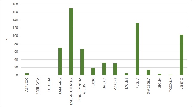
Figure 1: Number of shellfish concessions in state-owned areas by region (2022)
ISPRA processing of SID data - Port Captaincies Ordinances - Regional BUR
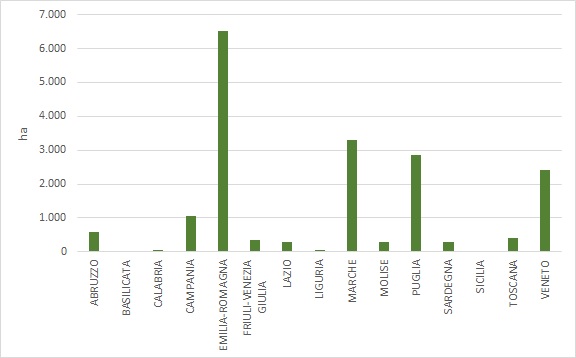
Figure 2: Extent in hectares of shellfish concessions in state-owned areas by region (2022)
ISPRA processing on SID data - Port Captaincies Ordinances - Regional BUR.
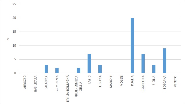
Figure 3: Number of fish farming concessions in state-owned areas by region (2022)
ISPRA processing of SID data - Port Captaincies Ordinances - Regional BUR
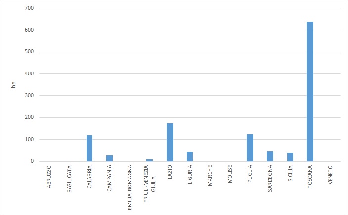
Figure 4: Extent in hectares of fish farming concessions in state-owned areas by region (2022)
ISPRA processing on SID data - Port Captaincies Ordinances - Regional BUR.
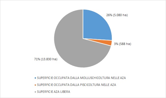
Figure 5: Area of AZAs already occupied by shellfish farming and fish farming (2022)
ISPRA processing on SID data - Port Captaincies Ordinances - Regional BUR
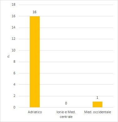
Figure 6: Number of AZAs in the Adritic, Ionian, and Med. subregions. Central and Med. West (2022)
ISPRA processing on data extracted from regional BURs.
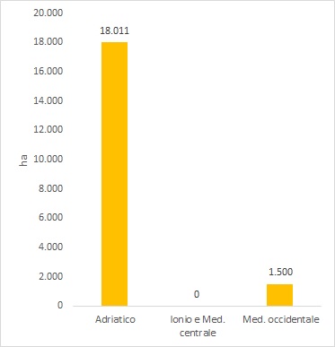
Figure 7: Extent of AZAs in the Adriatic, Ionian, Med. Central and Med. West subregions (2022)
ISPRA processing of data extracted from regional BURs
Italy’s jurisdictional maritime space extends from the coastline to the 12-nautical-mile limit, covering an area of approximately 14 million hectares. Of this space, only 19,722 hectares are allocated for aquaculture concessions of shellfish farming and marine fish farming. Shellfish farming occupies 93.8% of this space (18,500 ha).
Currently, the Emilia-Romagna region hosts 170 concessions and has the largest surface area dedicated to shellfish farming (6,504 ha), representing the 35.1% of the total national space used for this sector. It is followed by the regions of Marche (3,290 ha), Puglia (2,873 ha), Veneto (2,413 ha), and Campania (1,054 ha), which account for 17.7%, 15.5%, 13%, and 5.6% of the national surface area, respectively, with 31, 132, 103, and 71 concessions each. Other regions have concessions covering areas in the range of hundreds of hectares: Liguria (52 ha), Calabria (48 ha), and Sicily (33 ha), accounting for 0.2%, 0.2%, and 0.1% of the space allocated for shellfish farming, respectively, with 32, 1, and 4 concessions each. Basilicata has no shellfish farming concessions (Figures 1 and 2).
Marine fish farming occupies 6.19% of the maritime space dedicated to aquaculture (1,222 ha). Tuscany currently has 9 concessions over 639 ha, equivalent to 2% of the total national space allocated for fish farming. Lazio, Puglia, and Calabria follow with 172 ha, 124 ha, and 122 ha, respectively, accounting for 14%, 10%, and 9% of the total, with 7, 3, and 2 fish farming concessions. Sardinia, Liguria, Sicily, Campania, and Friuli-Venezia Giulia hold smaller areas in the range of tens of hectares. Abruzzo, Basilicata, Emilia-Romagna, Marche, Molise, and Veneto have no marine fish farming concessions (Figures 3 and 4).
Regarding AZAs (Allocated Zones for Aquaculture), they have been designated in only three regions: Marche (15 zones, approximately 13,700 ha) Emilia-Romagna (1 zone, 4,281 ha), and Tuscany (1 zone, 1,499 ha) (Table 1). The marine area identified by AZAs in these three regions (approximately 19,500 ha) is already occupied at 26% by shellfish farming concessions (5,080 hectares) and at 3% by fish farming concessions (588 hectares) (Figure 5).
The indicator is also presented in an aggregated form concerning the number of AZAs in the three maritime subregions defined by Directive 2014/89/EU. Regarding AZAs, in the Adriatic Sea subregion, 16 AZAs cover 18,010 ha; the Western Mediterranean Sea subregion has one AZA (1,499 ha); the Ionian Sea and Central Mediterranean subregion has none (Figures 6 and 7).