Marina Penna
In the assessment of the ecological quality of coastal marine environments within the framework of the European Directive 2000/60/EC (implemented through Legislative Decree 152/2006 and subsequent amendments), reference is made to the Biological Quality Element (BQE) Macroalgae. In Italy, as stipulated by Ministerial Decree 260/2010, this BQE is assessed using the CARLIT index (Cartography of littoral and upper-sublittoral benthic communities, or, in short, CARtography of LITtoral), which contributes to the classification of the ecological status of marine-coastal water bodies. For the period 2019–2021, over 80% of analyzed stations met the quality standard (at least "good").
The CARLIT classification method, provided for by Ministerial Decree 260/2010, introduces criteria for determining the ecological status of coastal marine water bodies, taking into account the high sensitivity of macroalgae populations present in the infralittoral fringe to various pressures. The CARLIT is a cartographic method exploiting the linear development of surface populations in microtidal environments, designed primarily for application along predominantly rocky coasts. For the study area to be deemed suitable for this method, it must consist mainly of cliffs, not necessarily continuous. At least 80% of the rocky zones must be composed of natural substrates. The CARLIT, based on visual sampling of surface algal communities, must be applied in spring, the period of peak development for conspicuous species.
Regarding classification, an "excellent" ecological status is defined by the presence of communities dominated by structuring brown algae (Cystoseira sp.), while a "poor" status is characterized by the dominance of opportunistic species with low morphological complexity, such as Ulvales (green algae), Bangiophycidae (red algae), or Cyanobacteria. The final result of the CARLIT index application does not provide an absolute value but directly determines the Ecological Quality Ratio (EQR).
The calculation of the Ecological Quality Ratio (EQR) is a dimensionless value between 0 and 1, allowing the ecological status of water bodies to be classified into five categories: excellent, good, moderate, poor, and bad.
To provide an ecological quality assessment for coastal marine environments within the framework of current legislation (Legislative Decree 152/2006 and subsequent amendments), by utilizing the Biological Quality Element (BQE) Macroalgae, integrating over time the effects of various physical, chemical, and biological alterations caused by pollutants in water and sediments, or by significant physical-morphological changes to the coastal stretch.
- Water Framework Directive (2000/60/EC)
- Legislative Decree 152/06: "Consolidated Law on Water."
- Ministerial Decree 56/09: "Regulation containing 'Technical criteria for the monitoring of water bodies and the identification of reference conditions for the modification of technical standards of Legislative Decree April 3, 2006, n. 152, concerning Environmental Standards, prepared pursuant to Article 75, Paragraph 3 of the same Legislative Decree.'"
- Ministerial Decree 260/10: "Regulation containing technical criteria for the classification of the status of surface water bodies, for the modification of technical standards of Legislative Decree April 3, 2006, n. 152, concerning Environmental Standards, prepared pursuant to Article 75, Paragraph 3 of the same Legislative Decree."
The classification limits that define the thresholds of the Ecological Quality Ratio (EQR) are:
- 0.75: High/Good
- 0.60: Good/Moderate
Ballesteros E., Torras X., Pinedo S., Garcia M., Mangialajo L., de Torres M. A new methodology based on littoral community cartography dominated by macro algae for the implementation of the European Water Framework Directive. Marine Pollution Bullettin 55(2007): 172-180
ARPA costiere
Dati EIONET/SOE e Piani di Distretto
www.sintai.isprambiente.it/faces/public/WFD/index.xhtml
Regional (5/8)
2019-2021
The ecological quality value (EQVcalc) is first quantified in each survey area for each relevant geomorphological category. The EQVcalc corresponds to the weighted average of the sensitivity values of the communities identified, based on the coastline length (calculated using GIS in the case of continuous cartography) or the number of sectors (sector-based cartography). The ecological quality values calculated using the same procedure at reference sites, for each relevant geomorphological category (EQVref), allow the calculation of the Ecological Quality Ratio (EQR). The EQR is a dimensionless value between 0 and 1 that permits the classification of survey areas into five ecological status classes: high, good, moderate, poor, bad.
81% of the analyzed stations fall within the "high" and "good" classes, whereas the remaining 19% of the stations are classified as "moderate," thus below the target set by the legislation (achievement of "good" status).
The trend is not yet definable due to the lack of robust data time series.
| Data |
|---|
Thumbnail
Headline
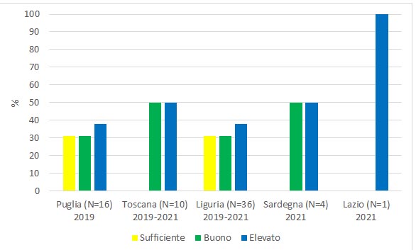
Figure 1: Ecological classification of stations by region according to the EQB Macroalghe (CARLIT) (2019-2021) Data source
Sintai Eionet SoE |
Thumbnail
Headline
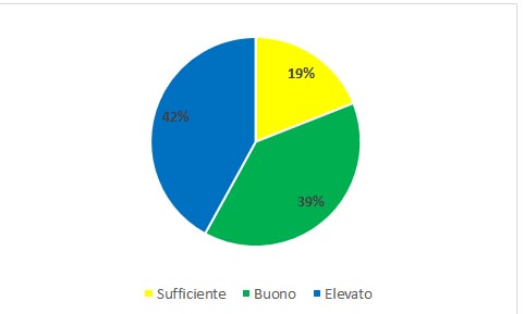
Figure 2: National Eco-Frame Classification of Stations Based on the EQB Macroalghe (CARLIT) (2019-2021) Data source
Sintai Eionet SoE |
The data from the period 2019–2021 show good national coverage. However, there is some heterogeneity in the number of stations classified for each analyzed region, ranging from a minimum of 1 station in Lazio to a maximum of 36 in Liguria (Figure 1). The regions with the highest percentage of stations in "moderate" status are Puglia and Liguria, both at 31%. In all analyzed regions, stations classified in the "high" category are present, and for Tuscany, Sardinia, and Lazio, these are equal to or greater than 50% (Figure 1).
It should be noted that Puglia presents a peculiar biogeographical situation due to specific edaphic conditions that give the classified communities a morpho-functional structure typical of the southern Adriatic.
In summary, at the national level, for the period 2019–2021, more than 80% of the stations meet the quality standard (at least "good") (Figure 2).