Devis Canesso, Marco Cordella, Franco Crosato
Continuous monitoring over time of the variations in the astronomical tidal amplitude allows us to highlight the hydrodynamic and therefore morphological changes within the Venice Lagoon, which owes its survival to the maintenance of very delicate environmental balances. The amplitude of the tide in the lagoon is compared with that characteristic of the Gulf of Venice, belonging to the same area from a geological point of view, but free from the anthropic intervention that characterizes the transition environment considered. The trend in tidal height is now substantially stable in almost the entire lagoon, after the strong variations observed as a consequence of profound changes introduced to the lagoon morphology during the first decade of the century.
The astronomical tidal range is that oscillatory movement of open water resulting from the rotation motion of the Earth around its axis and from the gravitational attraction forces of the Earth-Moon-Sun system. It occurs with variable entities in the different seas and oceans and in the Adriatic Sea it has the largest amplitude of the entire Mediterranean basin. The tidal wave, traveling up the Adriatic in an anti-clockwise direction, enters the lagoon through the three port inlets (Lido, Malamocco, Chioggia) and propagates inside it, adapting to the tortuous conformation and variable bottom of the channels. This morphological configuration, typical of coastal lagoons, is able to slow down the propagation and dampen the amplitude of the tidal wave. This indicator measures changes in astronomical tidal height over time at different points in the lagoon. The indicator is based on tidal data collected at the stations of the Mareographic Network of the Venice Lagoon and the Northern Adriatic coastal arc (RMLV), for the structure, structure and functionality of which please refer to the website www. venezia. isprambiente. it.
By monitoring long-term variations in the characteristics of tidal propagation within the Venice Lagoon, the indicator provides information on the morphological evolution of the lagoon basin and on any variations in the hydraulic structures of the lagoon, using the damping of the tidal wave compared to the open sea as a measurement parameter.
The indicator responds to the knowledge needs set out in Annex II of Directive 2000/60/EC regarding coastal waters and transition waters.
- Municipality of Venice-CPSM, ISPRA, CNR-ISMAR, Forecasts of tidal heights for the San Marco basin and current speeds for the Canal Porto di Lido - Venice Lagoon. Astronomical values. 2025, Municipality of Venice-CPSM, ISPRA, CNR-ISMAR
- Lionello, P., Barriopedro, D., Ferrarin, C., Nicholls, R. J., Orlić, M., Raicich, F., Reale, M., Umgiesser, G., Vousdoukas, M., and Zanchettin, D.: Extreme floods of Venice: characteristics, dynamics, past and future evolution (review article), Nat. Hazards Earth Syst. Sci., 21, 2705–2731, https://doi. org/10.5194/nhess-21-2705-2021, 2021.
- Matticchio B., Carniello L., Canesso D., Ziggiotto E., Cordella M. "Recent variations in tidal propagation in the Venice Lagoon: effects induced by the fixed works at the port inlets" in D'Alpaos L. (ed.) "The Venice Lagoon and the new works at the inlets", Istituto Veneto di Lettere Scienze e Arti, 2017, Venice.
- Ferrarin C., Tomasin A., Bajo M., Petrizzo A., Umgiesser G., "Tidal changes in a heavily modified coastal wetland", Continental Shelf Review 101 (2015) 22-23.
- Cordella M., Zampato L., Pastore F., Tomasin A., Canestrelli P., "The annual tide tables for Venice", Istituto Veneto LL. SS. AA. Acts 169 (2010-2011).
- D'Alpaos L. (2010) "The morphological evolution of the Venice Lagoon through the reading of some historical maps and its hydrographic charts", Municipality of Venice, Tide Forecasting and Reporting Center Institution.
- Ferla M., Cordella M., Michielli L., Rusconi A., "Long-term variations on sea level and tidal regime in the lagoon of Venice", Estuarine, Coastal and Shelf Science 75 (2007) 214-222.
- Sposito A. And Vultaggio M., (1988), "Harmonic analysis and tide prediction", Giannini Editore.
- IOC (1985), "Manual on sea level measurement and interpretation", UNESCO.
- Goldmann A. Et al. (1975), Characteristics of the tidal wave in the lagoon of Venice, Venice Scientific Center.
- Polli S. (1960), “The propagation of tides in the Adriatic”, Proceedings of the IX conference of the Italian Geophysical Association.
- Polli S. (1952), "Tidal propagation in the Venice lagoon", Annals of Geophysics, vol. N. 2. Pp. 273-292.
- Water Magistrate of Venice - Hydrographic Office, Hydrological Annals.
- www. venezia. isprambiente. it
ISPRA processing on data from the Municipality of Venice - Tide Forecasting and Reporting Center and ISPRA
www. venezia. isprambiente. it
www. comune. venezia. it/maree
Venice lagoon
1989-2024
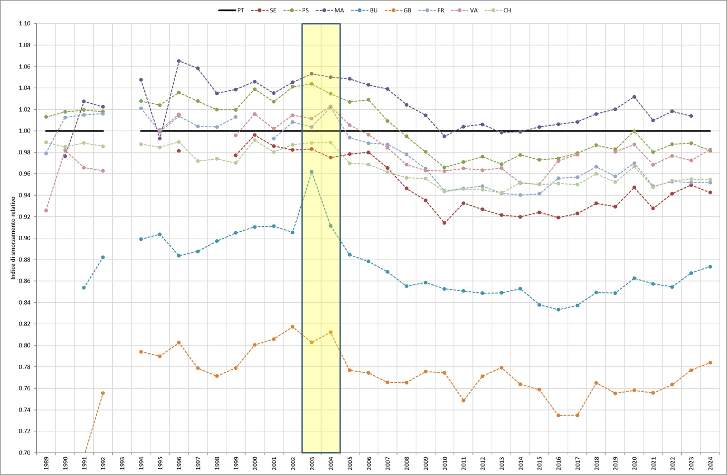
Starting from the historical series of tidal data observed in various stations of the lagoon, the calculation of the components of the astronomical tide is carried out for each of them and for each year by breaking it down into harmonics. For each component you get a delay and an amplitude. This indicator considers the sum of the amplitudes of the seven main diurnal and semi-diurnal components, sufficient to correctly describe the astronomical tide in the Upper Adriatic. In support, a "damping index" is also presented, calculated as the ratio between the tidal height of the various stations taken into consideration within the lagoon and that of the Acqua Alta Platform, located in the Gulf of Venice and representative of the conditions at sea just outside the Venice Lagoon. With the entry into operation of the mobile barriers of the Mo. S. E. At the three port inlets of Lido, Malamocco and Chioggia, which occurred for the first time on 3 October 2020, the data recorded by the stations inside the lagoon undergo further processing. In fact, from 2020, since the barriers exclude the lagoon from the natural tidal oscillation to protect Venice and its lagoon from the most severe high waters, in regulated lagoon conditions the measured data are purified of the closure periods of the mobile gates, with the addition of a further interval of 6 hours after reopening, the estimated time for the rebalancing of the lagoon's hydraulic structures.
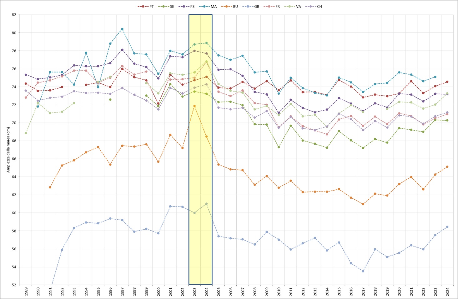
The Venice Lagoon is historically an environment by its nature in unstable equilibrium, being exposed both to the risk of siltation, due to the contribution of river sediments during floods, and to the risk of transformation into an arm of the sea, with consequent loss of specificity of a transition environment. To avoid the risk of progressive siltation, the Serenissima Republic of Venice in recent centuries carried out powerful hydraulic engineering interventions, which led to the diversion of the major rivers that originally flowed inside it or in any case near the port inlets (Piave, Sile, Brenta, Adige, Po). The other danger, coming from the sea, was faced by reinforcing part of the sandy coasts that separate the Venice Lagoon from the Adriatic Sea (the so-called "murazzi" of the Lido and Pellestrina). During the 19th century the port inlets were protected by long breakwaters in order to guarantee navigability and avoid the formation of coastal bars that would hinder navigation, by building the so-called "armours" at the inlets. During the twentieth century, large artificial canals were dug to facilitate port development (the Vittorio Emanuele III and the Malamocco-Marghera) and finally, after 2000, work began at the port inlets for the fixed works and the placement of mobile barriers against high tide flooding on the seabed (the so-called "Mo. S. E."). Having made this general premise on the historical events that affected the Venetian Lagoon, it is necessary to define a standard reference condition to which it is possible to refer in order to make comparisons over time. This condition is identified in the tide recorded at the Piattaforma Acqua Alta station, located 8 nautical miles off the Venetian coast. This observation point has the advantage of sharing the general characteristics of the Northern Adriatic basin and at the same time being free from the effects of interventions in the lagoon and works at the port inlets. Furthermore, it is not affected by the presence of the coast or piers, with the consequent effects related to wind and wave setup during the most intense meteorological events. The tide enters the lagoon through the three port inlets of Lido, Malamocco and Chioggia, propagating through the major navigable canals that depart from them and the vast system of natural meandering channels, interacting with the shallow waters, the mudflats and the salt marshes, morphological structures typical of a complex lagoon system. The longer the path of the tidal wave, the greater the effects on the amplitude and phase of the wave itself. In the case of artificial canals, with a rectified course, the inertial effects prevail over the dissipative ones and the damping is minimal or absent, while the opposite occurs on the shallows and along the small canals that cut through the mudflat or salt marsh areas, where the propagation of the tidal wave is hindered by the friction effects on the bottom. To account for this complexity, the monitoring sites that were chosen in the indicator are representative of different conditions, some more natural, others more artificial. Furthermore, an attempt was made to give homogeneous coverage to the entire lagoon basin, monitoring stations located both just inside the port inlets and in locations further inside the lagoon, up to the lagoon border (Figure 1). Compared to the substantially stable trend of the astronomical tide recorded in the Acqua Alta Platform, the variations found within the Venice Lagoon are notable, with differentiated responses in the various sites proposed in the analysis (Figure 2). The variations, observed over a multi-year interval, concerned all the stations inside the lagoon during the first decade of the century, while the reference station at sea remained essentially constant. This justifies the calculation of a "damping index", which uses the data from that station as a fixed reference. These variations are observed from 2005 to 2011, while the start of work at the port inlets refers to the two-year period 2003/2004. In recent years, tidal heights have stabilized at a new level, lower than that of the last century, with slight annual oscillations, inherent in the variability of the tidal phenomenon.
The substantial stability of the astronomical tide since the beginning of the 1990s was interrupted in all the stations inside the lagoon starting from the two-year period 2003-2004, with significant changes to the height of the astronomical tide in the lagoon mirror (Table 1). These anomalies, to be attributed to the modifications to the harbor inlets (fixed works on the seabed, lateral narrowings and lunations in front), reflect the modifications to the regime of the tidal currents. They also have negative repercussions on the erosive processes linked to the loss of sediments from the lagoon basin, which cause a consequent deterioration of the characteristics of a transition environment. In particular, we note a clear decrease in the height of the astronomical tide within the lagoon (but not at sea), approximately between 2005 and 2010/11. Over the last few years, however, there has been substantial stability of the indicator within the lagoon, which leads us to evaluate the trend as "stable". After the slight decrease in the amplitudes recorded by all the stations in 2022, in 2023 and 2024 there was a slight increase which brought the tide height back to the values of previous years (Figure 2). It is possible that the slight growth in the lagoon stations in recent years, and in particular in the years 2023-2024, is an effect of the smaller number of data, selected not randomly, corresponding to the actual closures of the Mo. S. E. System. The number of annual closures was in fact equal to 16 in the year 2020, 21 in 2021, 12 in 2022, 29 in 2023 and finally 30 in 2024, with clear growth in the last two years.
| Data |
|---|
Thumbnail
Headline
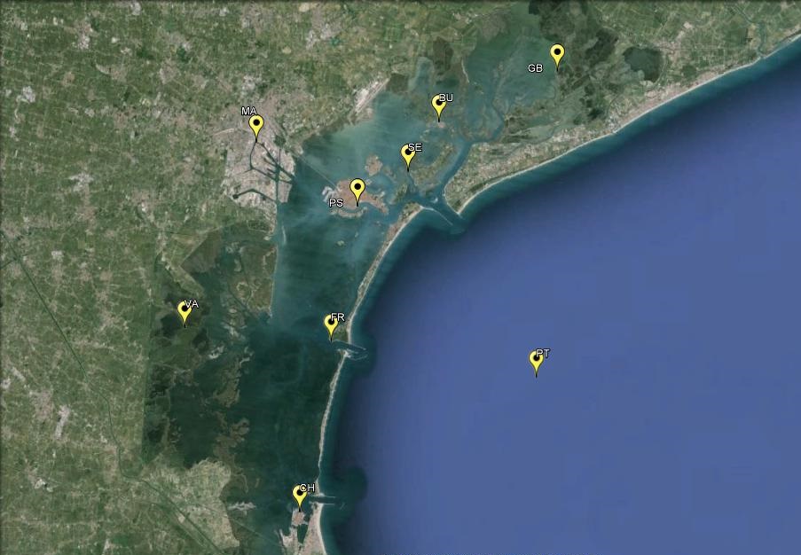
Figure 1: Map of the tidal stations Data source
ISPRA elaboration on data Municipality of Venice - Forecast Center and Tide and ISPRA Reports Data legend
Sigle stations: PT: Piattaforma Acqua Alta; BU: Burano; CH: Chioggia Vigo; FR: Faro Rocchetta; GB: Grassabò; MA: Marghera; Se: Sant'Erasmo; PS: Punta Salute; VA: Valle Averto |
Thumbnail
Headline
Figure 2: Astronomical tidal height Data source
ISPRA processing on data from the Municipality of Venice - Tide Forecasting and Reporting Center and ISPRA Data legend
Station abbreviations: PT: High Water Platform; BU: Burano; CH: Chioggia Vigo; FR: Rocchetta lighthouse; GB: Grassabò; MA: Marghera; SE: Saint Erasmus; PS: Punta Salute; VA: Valle Averto |
Thumbnail
Headline
Figure 3: Damping of the astronomical tide Data source
ISPRA processing on data from the Municipality of Venice - Tide Forecasting and Reporting Center and ISPRA Data legend
Station abbreviations: PT: High Water Platform; BU: Burano; CH: Chioggia Vigo; FR: Rocchetta lighthouse; GB: Grassabò; MA: Marghera; SE: Saint Erasmus; PS: Punta Salute; VA: Valle Averto |
Headline
Table 1: Astronomical tide height Data source
ISPRA processing on data from the Municipality of Venice - Tide Forecasting and Reporting Center and ISPRA Data legend
Station abbreviations: PT: High Water Platform; BU: Burano; CH: Chioggia Vigo; FR: Rocchetta lighthouse; GB: Grassabò; MA: Marghera; SE: Saint Erasmus; PS: Punta Salute; VA: Valle Averto |
The trend of the astronomical tide is consistent within the lagoon in the first years of the available series, however, in the years following the two-year period 2003-2004 (beginning of work at the harbor inlets) a general loss in the height of the astronomical tide was detected, estimated at between 4 and 8 cm in all stations inside the lagoon (Figure 2). It should be noted that the reduction in tidal height does not occur synchronously in all locations: for the stations closest to the port inlets of Lido and Chioggia it occurs by 2010, while for those fed by the Malamocco inlet there are slower dynamics, also accompanied by a greater loss of height. Finally, the extreme northern lagoon, very far from the sea, demonstrates that its astronomical nature has not yet fully stabilized. To facilitate the reading of the indicator, we also propose the evaluation of the relative damping of the tidal amplitude, expressed as the ratio between the annual height of the individual stations and that of the High Water Platform, considered representative of the northern Adriatic basin. In this way the Platform series remains fixed at 1 and the relative variations recorded by the internal stations are detected (Figure 3). This approach has the advantage of clearly highlighting the response of the Venice Lagoon to the profound interventions that have rigidly modified the morphology of the port inlets, in particular the narrowing of the width of the inlets and the reduction of the seabed to a fixed level, preliminary works for the installation of the caissons and mobile bulkheads of the Mo. S. E. Despite some differences, the height of the tide varies in all the stations considered (Table 1). The interventions have modified the characteristics of the flow entering and exiting each port inlet, altering the lagoon areas of respective influence. The northern portion (Burano and Grassabò), although recording decreases in the height of the astronomical tide, suffers the effects of this variation to a lesser extent than other areas, which see the tidal amplitude significantly reduce over the years. Furthermore, some stations respond more clearly than others: Faro Rocchetta, located just inside the mouth of the port of Malamocco, Punta Salute and Marghera, located in the central lagoon, one in the historic center, the other in an industrial area, alongside marginal canals, all show a similar trend, with a clear reduction until 2010 and a subsequent period of relative stability. Finally, in the last decade, the various locations within the lagoon responded differently compared to the Gulf of Venice (Platform station) to the different stresses and morphological changes of all the port inlets (Lido, Malamocco and Chioggia). These variations are directly reflected in the movement of the watersheds of the different sub-basins and in the resulting alteration of the lagoon currents. In conclusion, the changes highlighted after 2003-2004 have given rise to a lagoon with a profoundly modified hydraulic structure compared to the previous situation, with implications in terms of average depth of the seabed, current structure, solid transport and sediment loss which are still to be evaluated and monitored in their complexity over time.