Domenico Berti, Mauro Lucarini

In 2023, Italy experienced one of the hottest years in the last 150 years, second only to 2022. The average and maximum temperatures reached new records with October recording temperatures more than 3°C higher than the 1991-2021 average, marking the highest value since 1961. During the summer, intense heatwaves affected the country, with record temperatures of 48.2°C recorded on July 24 in Jerzu and Lotzorai in Sardinia, and 41.2°C in Rome in early August. Drought continued to be a significant problem, with Northern and Central Italy experiencing severe drought conditions in the first four months of the year, which later eased. However, in the last three months of the year, Sicily and parts of Ionian Calabria suffered from extreme drought with a significant precipitation deficit.
Extreme weather events affected several regions, causing severe damage. In May, Emilia-Romagna was devastated by two exceptional rainfall events, leading to flooding, landslides, and 17 fatalities. On November 2, heavy thunderstorms in Tuscany caused flooding and 8 deaths, with exceptional rainfall recorded in the provinces of Pisa, Livorno, Pistoia, and Prato.
In summary, 2023 was characterized by record temperatures, persistent drought, and extreme weather events that had a significant impact on various italian regions.
The indicator provides information on flood events caused by significant meteorological phenomena that occurred across the entire national territory, defining their most important economic impacts. The data, drawn from ISPRA technical reports and/or thematic technical reports from regional ARPA and Civil Protection Functional Centers, as well as from decrees and resolutions at both the national and local levels, concern the number of fatalities and the resources needed for damage restoration and/or risk mitigation (years 1951-2022). For the period from 2002 to the present, information is also provided on the pluviometric characteristics of the events (duration of rainfall, maximum rainfall in 24 hours, total accumulated event), the types of land degradation phenomena, the main effects on the land, and finally, emergency measures adopted to address the event or mitigate its effects.
To provide, within the framework of hydrogeological hazards at the national level, an updated archive of flood events caused by intense meteorological phenomena, highlighting their impact on the territory in terms of economic damages and human impact, also for the purpose of evaluating any ongoing climate changes.
The legislation aims to mitigate the impact of floods on the territory. The main national legislative references regarding "floods" are Law 183/89 and Legislative Decree 180/98 (converted into Law 267/98) and its amendments. At the European level, the key references are Directive 2000/60 for the protection of surface, transition, coastal, and groundwater for better mitigation of the effects of floods and droughts, and later, Directive 2007/60/EC for the assessment and management of flood risks. In the event of an incident, an emergency state is declared with a DPCM, followed by any ordinances for the allocation of funds, both for initial emergencies and for final damage remediation interventions.
AA.VV. (1969) - L'evento alluvionale del novembre 1966. Ministero dei lavori pubblici, Ministero dell'agricoltura e delle foreste, Commissione interministeriale per lo studio della sistemazione idraulica e della difesa del suolo. Art. 14 della legge 27-7-1967 n. 632. Roma, Istituto poligrafico dello Stato, 193 pp.
Benedini M., Gisotti G. (2000) - Il dissesto idrogeologico. Previsione, prevenzione e mitigazione del rischio, Scienze e Tecnica. Carocci ed., Roma.
Cardinali M., Cipolla F., Guzzetti F., Lolli O., Pagliacci S., Reichenbach P., Sebastiani C. & Tonelli G. (1998) - Catalogo delle informazioni sulle località italiane colpite da frane e da inondazioni.
Progetto AVI, CNR-GNDCI Pubblicazione n. 1799. 2 Volumi. Crescenti U. (2003) – Il dissesto idrogeologico in Italia. Scienza e Tecnica, SIPS, anno LXVI – n. 393, maggio 2003, pp. 1-9.
CSFM (1984) – L’alluvione del fiume Taro nel novembre 1982. In Convegno sul dissesto territoriale del novembre 1982 nelle Valli del Taro e del Ceno, Atti del Convegno.
Centro Studi per la Flora Mediterranea, Borgo Val di Taro (PR). FlaNET (1999) – ASEVA. Archivio Storico degli Eventi di carattere Ambientale. A cura della Fondazione Lombardia per l'Ambiente, Milano.
Guha-Sapir D., Below R., Hoyois Ph. (2009) - EM-DAT: The CRED/OFDA International Disaster Database – www.emdat.be – Université Catholique de Louvain – Brussels – Belgium.
Guzzetti F. & Tonelli G. (2004) Information system on hydrological and geomorphological catastrophes in Italy (SICI): a tool for managing landslide and flood hazards. Natural Hazards and Earth System Sciences, Vol. 4:2, 213-232.
Il Giornale della Protezione Civile (Quotidiano on-line, articoli vari).
ISPRA (2024) – Il clima in Italia nel 2023. Report SNPA, 250/2024.
Leggi, Decreti, Ordinanze dello Stato e delle Regioni.
POLARIS Project (2024) – Rapporto Periodico sul Rischio posto alla Popolazione Italiana da Frane e Inondazioni, pubblicato dall’IRPI (CNR).
Rapporti Tecnici vari pubblicati a cura degli Enti Pubblici (Regioni, Comuni, ARPA)
Siti internet di testate giornalistiche sia nazionali, sia locali.
The significance of the indicator is limited to the socio-economic impact of flood events, while the causes behind the event (apart from the meteorological phenomenon) are not analyzed here. This parameter could be qualitatively enhanced if information were available, for example, on the influence exerted by human activities in terms of predisposing and/or triggering factors of land degradation and the possible amplification of damage. To reduce this type of limitation, a column with descriptions of the effects on the land related to the flood event has been included in Table 3. However, this requires an extensive historical series to provide comparable and assessable data. The severity and spatial extent of the effects, along with the presence/absence of various emergency and post-emergency regulatory measures, are the most important criteria for selecting events to be studied and cataloged. The need to carry out this selection year by year may represent a partial limitation to the completeness of the catalog itself. In regions that do not routinely conduct reporting activities, data accessibility can sometimes be difficult.
The limitations outlined above are progressively reduced with the availability, over time, of more detailed data on the historical series, even as the number of years of observation increases. The situation could further improve in the future with the acquisition of indications for the causes of the phenomenon, i.e., again, for the influence exerted by the anthropogenic factor on the damage on the basis of a multidisciplinary approach and with reference to what is defined in the section on the limitations of the indicator. This further action requires the direct involvement of local structures that are currently the source of data (ARPA, Regions; Municipalities, Provinces, etc.) or entities in various capacities interested in their collection and analysis.
Local governments
APAT (Agency for Environmental Protection and Technical Services)
ARPA/APPA (Regional and Autonomous Provinces Agencies for the Protection of the Environment).
Benedini M. & Gisotti G. (2000) “The hydrogeological instability”, Carocci Editore
Official Bulletins
BUR (Official Regional Bulletins).
Civil Protection Functional Centers
CNR
ISPRA (Superior Institute for Environmental Protection and Research)
ISTAT
MIPAAF (Ministry of Agriculture, Food and Forestry)
OSMER-FVG (Regional Meteorological Observatory and Natural Hazards Management of Friuli-Venezia-Giulia)
Civil Defense
Provinces
Regions
SNPA (National System for Environmental Protection)
Based on what is available online, either in the form of databases or reports, all hydrometeorological, geomorphological, and hydrogeological information produced by the ARPAs and/or Functional Centers of the regions is collected and processed, which is then supplemented by the various more qualified news sources. The various analyses are then accompanied by references to resolutions, ordinances, and decrees issued at the national and regional levels for emergencies or by information provided in the published scientific literature.
National
1951- 2023
After collecting and representing the data regarding the general characteristics of the events in the various tables, a subsequent phase involved calculating the total number of victims for each year and estimating the damage caused by the events at the national scale. To make data comparable for different years and provide a reference against the national economy, the damages were related to the GDP value (based on ISTAT data) for the year the events occurred. It should be noted that, for the damage/GDP calculation, in cases where information on damage estimation was unavailable, the figure relating to the allocated funds is reported.
The status of the phenomena covered by the indicator is reflected in the cataloged data. However, there are no objective reference parameters for its evaluation, as various factors act concurrently, and their interrelations and/or specific weight are unclear. In particular, the individual effects of climatic parameters, anthropogenic land transformations, and risk mitigation actions cannot be definitively defined. Specifically, the main parameters of the indicator, such as the number of human losses and economic damages relative to the damage/GDP ratio, show values in 2023 that are higher than those in 2022. This trend seems to be consistent over the last three years.
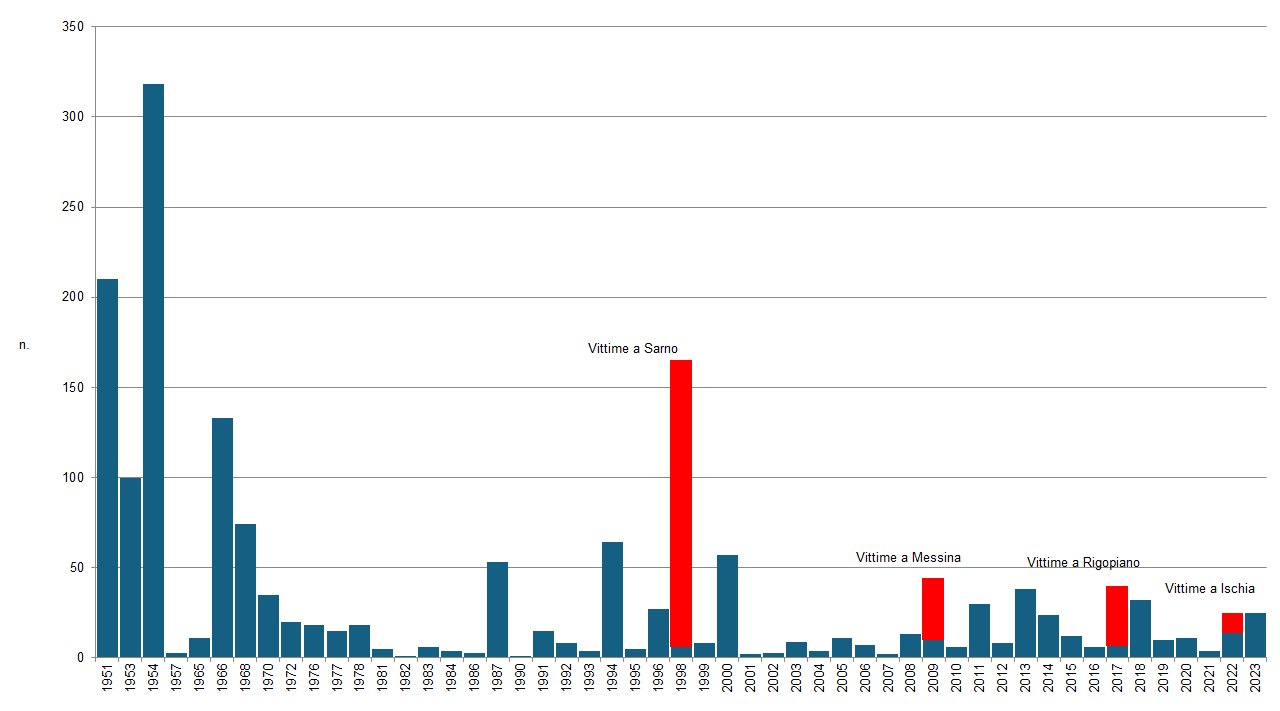
The data series shown in Figure 2 generally indicates a decrease in damages relative to GDP up until the 2001–2007-time frame, with a few exceptions. This change could be attributed not only to better risk mitigation efforts but also to a natural periodic variation in the intensity and duration of the phenomena. However, this trend seems to lack continuity in the period between 2008 and 2023, during which the average value of the damage/GDP ratio shows modest fluctuations, with years characterized by small positive peaks, such as 2014, 2015, 2018, 2022, and 2023, and years with declining values, such as 2019, 2020, and 2021. The two events, which occurred in Emilia-Romagna in May and in Tuscany in November, caused a significant positive spike in the number of deaths (Figure 1), excluding the events in Sarno (1998), Messina (2009), and Ischia-Casamicciola (2022), but overall confirming a continuous annual fluctuation in values over the last decade. Therefore, an overall evaluation of the trend remains quite challenging for this parameter.
| Data |
|---|
Headline
Table 1: Rainfall aspects of flood events (2023) Data source
ISPRA elaboration on data from: Dipartimento Nazionale della Protezione Civile; Regione Campania, Regione Sardegna, Regione Marche-Protezione Civile, Regione Sicilia-Protezione Civile, ARPA Emilia-Romagna, ARPA Liguria, ARPA Toscana, Centro Meteo Lombardo. |
File
Headline
Table 2: Socioeconomic impacts of flood events (2023) Data source
ISPRA elaboration on data from: Dipartimento Nazionale della Protezione Civile; Regione Marche-Protezione Civile, Regione Sicilia-Protezione Civile,; MiPAAF; Atti e Decreti del Governo della Repubblica (pubblicati su G.U.); Atti e Decreti delle Giunte Regionali; http://www.protezionecivile.it; http://polaris.irpi.cnr.it/; https://cittaclima.it/. Data legend
I = Hydraulic, F = Landslide, C = Coastal |
Headline
Table 3: Ground effects of flood events (2023) Data source
ISPRA processing on data and information from: Dipartimento Nazionale della Protezione Civile; Regione Marche-Protezione Civile, Regione Sicilia-Protezione Civile, ARPA Emilia-Romagna, ARPA Liguria, ARPA Toscana, Centro Meteo Lombardo; MiPAAF; Atti e Decreti del Governo della Repubblica (pubblicati su G.U.); Atti e Decreti delle Giunte Regionali; Agenzie di Stampa; https://cittaclima.it/. Note
*Where data on estimated damages could not be found, data on disbursed resources were used |
Headline
Table 4: Summary of aggregate flood events by region (2023) Data source
ISPRA elaboration on data from: Dipartimento Nazionale della Protezione Civile; Regione Campania, Regione Sardegna, Regione Marche-Protezione Civile, Regione Sicilia-Protezione Civile, ARPA Emilia-Romagna, ARPA Liguria, ARPA Toscana, Centro Meteo Lombardo; MiPAAF; Atti e Decreti del Governo della Repubblica (pubblicati su G.U.); Atti e Decreti delle Giunte Regionali; http://www.protezionecivile.it; http://polaris.irpi.cnr.it/; https://cittaclima.it/. |
Thumbnail
Headline
Figure 1: Victims of major floods in Italy (1951-2023) Data source
ISPRA estimates on data from: ISTAT; CNR-GNDCI Progetto AVI; MiPAAF; Protezione Civile Nazionale; Legambiente (https://cittaclima.it/); CNR-Polaris (http://polaris.irpi.cnr.it/); Agenzie di Stampa; Atti e Decreti del Governo della Repubblica (pubblicati su G.U.); Atti e Decreti delle Giunte Regionali (pubblicati sui B.U.R.); Benedini & Gisotti (2000) “Il dissesto idrogeologico”. |
Thumbnail

Headline
Figure 2: Estimated total damage to GDP (1951-2023) Data source
ISPRA estimates on data from: ISTAT; CNR-GNDCI Progetto AVI; MiPAAF; Protezione Civile Nazionale; Agenzie di Stampa; Atti e Decreti del Governo della Repubblica (pubblicati su G.U.); Atti e Decreti delle Giunte Regionali (pubblicati sui B.U.R.); Benedini & Gisotti (2000) “Il dissesto idrogeologico”. |
Thumbnail
Headline
Abstract: Villafranca (FC), 17 maggio 2024 Data source
Protezione Civile Nazionale Data legend
Allagamenti conseguenti alla rottura arginale del fiume Montone, Villafrabca (FC). DPC. |
Tables 1 and 2 present data on the 11 flood events that occurred in 2023, containing information on the general characteristics of the phenomena (event period, location, affected river basin, rainfall data) and their socio-economic impacts (possible casualties, legislative measures adopted for risk mitigation and damage restoration, type of land degradation). On a national scale, 2023 was marked by a significant anomaly in cumulative precipitation in Italy, with negative values compared to the 1991-2021 average, ranking as the driest year in the entire series since 1961. The situation was particularly critical in the North, especially in Emilia-Romagna, where, in the first quarter, the persistence of anticyclonic blocking conditions was only alleviated during the summer and autumn months, despite the severe flooding events that occurred in May. In many cases throughout the year, dry periods (late winter and spring) alternated with phases of heavy rainfall, often concentrated within 12/24 hours, both in the summer and autumn seasons, causing floods and gravitational landslides. Drought and floods sometimes affected the same territories in successive periods, as seen in Sicily and Emilia-Romagna. The spatial extent of the affected areas was, in all cases, limited to regional or even sub-regional levels. Nine out of the eleven events recorded exhibited a markedly impulsive nature, with high hourly rainfall but much less significant total event accumulations (Table 1), supporting the hypothesis of climate change that indicates a shift in rainfall patterns. In many cases, the high rainfall accumulations concentrated over a short period caused severe ground effects, both geomorphological and hydraulic, leading to fatalities in six events, with a total of 25 deaths (Table 2), 20 of which occurred in the Emilia-Romagna and Tuscany events. The corresponding ground effects, primarily consisting of gravitational landslides and flash floods, were caused by rainfall with maximum cumulative totals close to 300 mm in 24 hours, but with extremely high peaks often exceeding 100 mm in just over 1 hour (Table 1). The two events that affected Emilia-Romagna in May and the one in the Bisenzio and Ombrone Pistoiese basins in November stand out for their vastness, the number of recorded landslides (thousands), the number of overflowing rivers and streams (24), the damage to infrastructure, agriculture, industry, housing, and the number of fatalities.
Table 3 provides a summary of the major floods in Italy in 2023, relating to damage estimates compared to the GDP of the same year, along with a summary of the main ground effects (flooding, landslides, embankment failures, overtopping, siphoning, bank erosion, etc.). For information regarding the fatalities caused by the events and the economic damage compared to GDP, reference can be made to Figures 1 and 2. In both cases, the values shown reflect significant increases compared to previous years. Finally, Table 4 provides a summary of the data related to the affected river basins, in terms of allocated funds and legislative measures adopted, broken down for the areas affected by one or more events, to provide a regional overview.
At the national level, as previously mentioned, three events with significant human losses characterized 2023. The first two in chronological order occurred on May 2-3 and May 16-17 in the provinces of Modena, Bologna, Ravenna, Forlì-Cesena, Rimini, Pesaro-Urbino, and Ancona, causing widespread and severe landslides, road closures, embankment failures, and flooding in 31 river basins, along with numerous victims (27 in total, 25 of which were due to hydrological phenomena). In this initial phase, the most notable event was the flooding in the cities of Cesena and Forlì due to the severe flooding of the Savio and Montone rivers, as well as the urban centers of Faenza and Riccione on May 16.
The third event, occurring on November 2-3, mainly affected the provinces of Florence, Prato, and Pistoia, impacting the Bisenzio and Ombrone Pistoiese river basins as well as several tributaries and diversion channels, causing extensive flooding in populated areas, agricultural and industrial zones, with particularly severe damage in the municipalities of Prato and Campi Bisenzio, as well as in Quarrata, Montemurlo, and Livorno (Rio Maggiore stream).
The highest hourly rainfall peaks were recorded during the May and November events, with more than 200 mm in just a few hours in all three cases, and a total cumulative rainfall of around 300 mm or more over 36 hours. It should be noted, however, that the highest cumulative rainfall, distributed over about 48 hours, was recorded during the event of February 8-10 in Sicily, in the province of Syracuse, which, although it did not cause any fatalities, certainly caused extensive damage to agriculture.