Giovanni Finocchiaro, Silvia Iaccarino
Coastal tourism infrastructure, and marinas in particular, exert significant pressures on marine and coastal ecosystems. The indicator assesses the potential environmental pressure associated with recreational boating through the total number of berths and their density per kilometre of coastline at regional level.
In 2024, a total of 162,745 berths was recorded in Italy, with a national average density of 19.7 berths per kilometre of coastline. These values show a slight increase compared with 2023. The territorial distribution remains highly uneven, with particularly high densities in some regions characterised by a strong concentration of boating infrastructure.
Ports are important tourist attractions along the coast. They provide added value to the services offered in a given location and tend to attract people with a specific demand for tourism.
The construction of marinas may damage coastal ecosystems and have an impact on coastal morphology. However, the size of a port, in terms of the number of berths, is a relevant indicator of intensity of use.
The greater the number of moorings or berths available in a seaport, the greater the potential pollution resulting from boat maintenance activities and the greater the pressure exerted by recreational maritime activities.
Studies have shown that antifouling residues are present in many port sediments, posing a threat to the local marine environment in general.
The indicator shows, for coastal regions, the number of berths per kilometre of coastline.
Monitor the potential pressure that marinas generate on the local marine environment.
There are no objectives to be met for the indicator, however it is part of a regulatory framework that takes into account European and national policies on sustainable tourism, European regulations relating to marine-coastal ecosystems (e.g. Marine Strategy Framework Directive and/or Habitats Directive, national and/or local planning regulations).
Anthony, E.J. (1997): The status of beaches and shoreline development options on the French Riviera: a perspective and a prognosis. Journal of Coastal Conservation 3: 169-178.
Cassi, R., Toulouse, I. & De Mora, S. (2008): A survey of antifoulants in sediments from Ports and Marinas along the French Mediterranean coast. Marine Pollution Bulletin 56 (11): 1943-1948.
Konstantinou, I.K. & Albanis, T.A. (2004): Worldwide occurrence and effects of antifouling paint booster biocides in the aquatic environment: a review. Environment International 30: 235-248.
Martínez, K., Ferrer, I., Hernando, M.D., Fernández-Alba, A.R., Marcé, R.M., Borrull, F. & Barceló. D. (2001): Occurrence of Antifouling Biocides in the Spanish Mediterranean Marine Environment. Environmental Technology 22 (5): 543-552.
ISPRA (Higher Institute for Environmental Protection and Research)
MIT (Ministry of Infrastructure and Transport)
Coastal regions
2010-2024
Total berths per km of coast
Number of berths by region, type of facility, and length classes, and percentage of distribution per km of coastline.
In 2024, Italy counted a total of 162,745 berths, compared with 161,778 in 2023, corresponding to an increase of approximately 0.6%. The national average density increased from 19.6 to 19.7 berths per kilometre of coastline (Table 1).
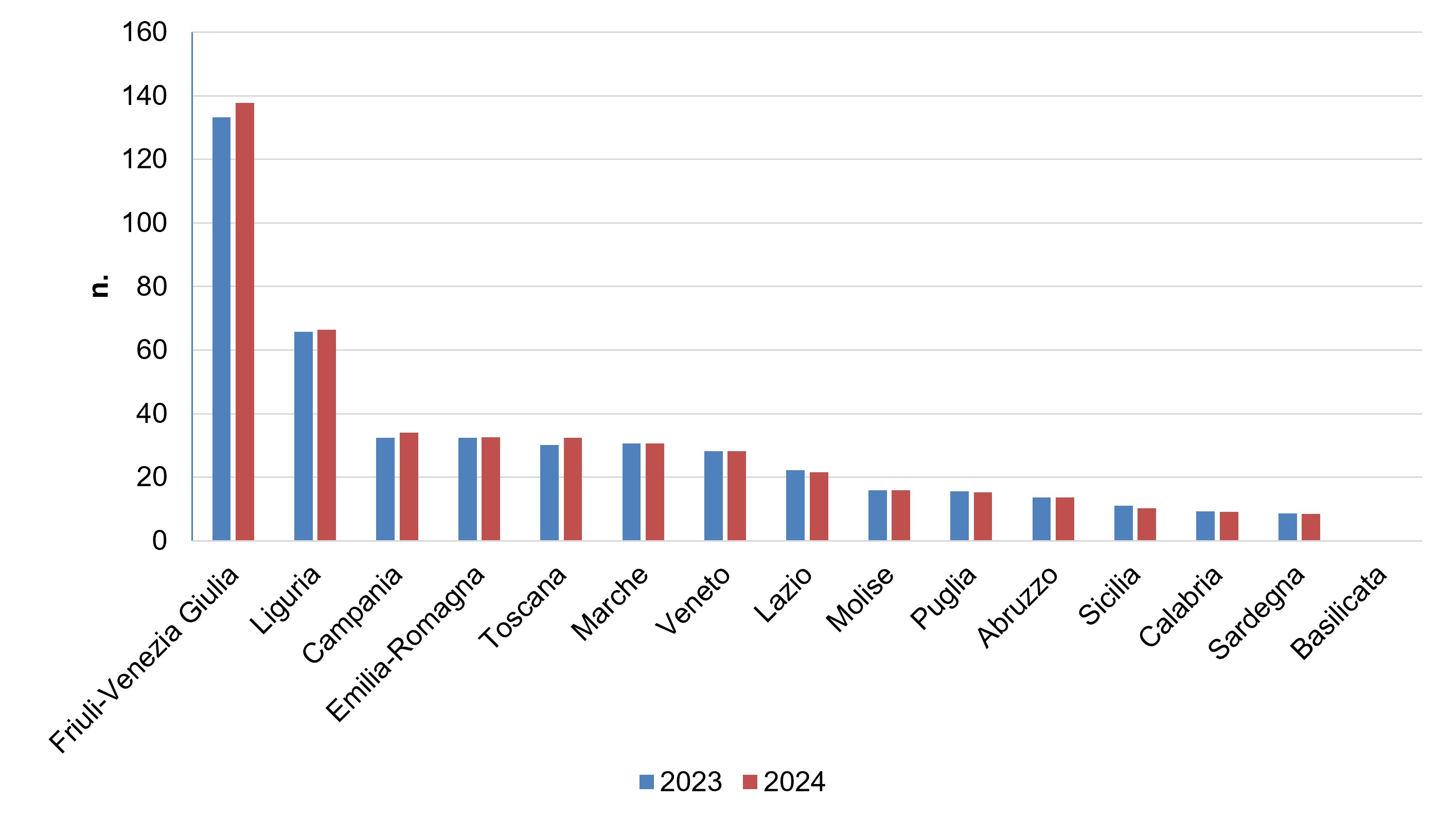
The regional picture continues to show very marked differences. Friuli-Venezia Giulia records the highest density, equal to 137.7 berths per kilometre, up from 133.3 in 2023. It is followed by Liguria, with 25,093 berths and a density of 66.4 berths per kilometre; Campania, with 34.0; Emilia-Romagna, with 32.6; and Tuscany, with 32.5 berths per kilometre.
Values substantially below the national average are recorded in Sardinia, with 8.4 berths per kilometre; Calabria, with 9.1; Sicily, with 10.3; and Abruzzo, with 13.6 (Table 1 and Figure 2).
Compared with 2023, the increase in berths is concentrated mainly in Tuscany, with 1,469 additional berths; Campania, with 816; and Friuli-Venezia Giulia, with 514. Other regions instead recorded decreases, particularly Sicily, with 1,221 fewer berths; Apulia, with 300 fewer; Sardinia, with 283 fewer; and Lazio, with 282 fewer. This highlights a non-uniform territorial dynamic (Figure 2).
Overall, the status is confirmed as poor from an environmental point of view. The slight increase in national infrastructure endowment is accompanied by the persistence of very high infrastructure concentrations along certain coastal stretches, with potential pressures on marine habitats, water quality, seabeds and coastal dynamics.
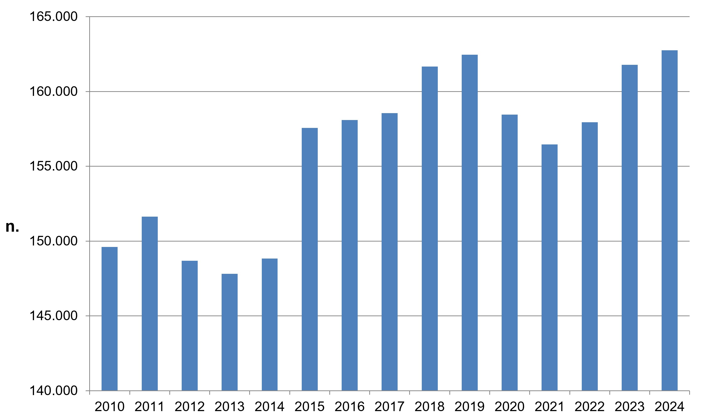
During the 2010-2024 period, the total number of berths showed a pattern characterised by fluctuations, but with an underlying increasing trend. The number of berths rose from 149,605 in 2010 to 162,745 in 2024, corresponding to an overall increase of approximately 8.8% (Figure 1).
After the growth observed up to 2019, when the number of berths reached 162,455, a contraction was recorded in the 2020-2021 period, with a minimum of 156,465 berths in 2021. From 2022 onwards, infrastructure capacity began to increase again: 157,950 berths in 2022, 161,778 in 2023 and 162,745 in 2024, slightly exceeding even the 2019 level (Figure 1).
The increase between 2023 and 2024 is limited, at +0.6%, but it forms part of a long-term dynamic in which the overall infrastructure endowment tends to remain at high levels.
Regional density also confirms a strongly differentiated distribution. Between 2023 and 2024, density increased, for example, in Friuli-Venezia Giulia, Liguria, Campania and Tuscany, while it decreased in some southern and island regions (Figure 2).
Overall, the long-term trend can be assessed as moderately negative from an environmental point of view, because the increase in berths determines a potential growth in pressures on coastal areas, especially in territories already characterised by high infrastructure densities.
The assessment does not negatively concern the development of the recreational boating sector itself, but highlights the need for such growth to be accompanied by careful sustainable management of infrastructure and by effective measures for the protection of marine and coastal ecosystems.
| Allegati |
|---|
Titolo
Table 1: Number of berths by region, type of structure and length classes and percentage of distribution per km of coast (30/9/2024) Fonte
ISPRA processing on MIT and ISPRA data Note
According to Article 2 of Presidential Decree No. 509 of 2 December 1997, structures intended for recreational boating can be classified into three types: tourist port, tourist landing place and mooring point. |
Thumbnail
Titolo
Figure 1: Number of berths in Italy Fonte
ISPRA processing of ISPRA and MIT data |
Thumbnail
Titolo
Figure 2: Number of berths per kilometre of regional coast (2023-2024) Fonte
ISPRA processing of ISPRA and MIT data |
In 2024, the distribution of the 162,745 berths along the Italian coastline continues to be highly uneven. Liguria records the highest absolute number, with 25,093 berths, followed by Tuscany with 20,969, Sardinia with 18,171, Campania with 17,080, Sicily with 16,505 and Friuli-Venezia Giulia with 15,976 (Table 1).
The absolute number of berths must, however, be read together with the length of the regional coastline. From this perspective, Friuli-Venezia Giulia stands out particularly clearly: with 116 km of coastline considered, it reaches 137.7 berths per kilometre. Liguria also shows high infrastructure pressure, with 66.4 berths per kilometre, a value more than three times higher than the national average of 19.7.
Campania, Emilia-Romagna and Tuscany record densities above 30 berths per kilometre (Table 1 and Figure 2).
The historical series confirms that the potential pressure associated with recreational boating infrastructure does not show a structural reduction. Compared with 2010, approximately 13,100 more berths are recorded in 2024. Growth is not linear and includes phases of contraction, but the most recent value is among the highest in the entire series (Figure 1).
The territorial distribution of the indicator therefore suggests the need for differentiated policies at regional and local scale.
In areas already characterised by high infrastructure densities, it would probably be preferable to prioritise the redevelopment and efficiency improvement of existing facilities rather than the creation of new capacity, accompanying port management with measures for the protection of coastal habitats and seabeds, water quality, waste management and the reduction of emissions associated with boating.
In other words, differentiated coastal planning policies would be desirable, aimed at balancing the needs of tourism and economic development with the protection of marine and coastal ecosystems.