Marco D'Antona, Marco Di Leginio, Ines Marinosci
The consumed soil within the terrestrial portion of Italian protected areas included in the Official List of Protected Areas (EUAP, 2010, updated with newly designated national protected areas established after 2010) is assessed with reference to National Parks, State and Regional Nature Reserves, Regional Nature Parks, and the other categories of national and regional protected natural areas.
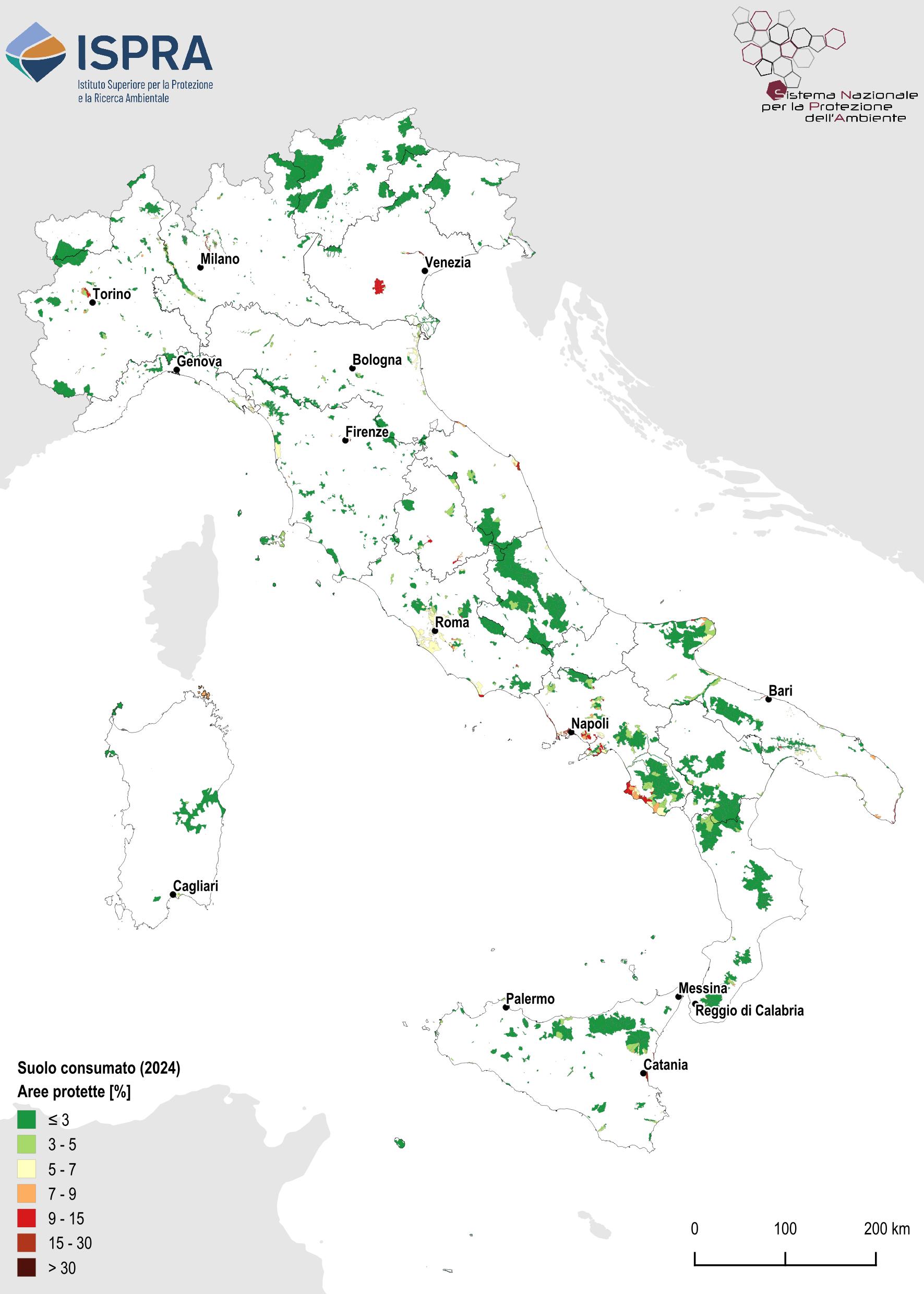
As of 2024, 1.88% of the more than three million hectares of terrestrial EUAP areas (58,328 hectares) has been consumed, with the highest percentage in Campania (3.82%) and the lowest in the Alpine regions (Valle d’Aosta, Trentino-Alto Adige, and Friuli Venezia Giulia).
Between 2023 and 2024, Italian protected areas recorded an increase in soil consumption that remained below the national average (0.26 m² of change per hectare, compared to a national value of 2.60 m²/ha), amounting to a total of 80.96 hectares of newly consumed soil, more than 46% of which is concentrated in Abruzzo, Lazio, and Campania.
The indicator evaluates the amount of land consumed and new land consumption within the territory of the Italian terrestrial protected areas that are included in the Official List of Protected Areas (EUAP, last update in 2010, updated with the new protected areas established at national level after 2010), and is evaluated with reference to national parks, natural reserves (state and regional), regional natural parks and other types of national and regional protected natural areas. I am [SI1] the perimeters of Marine Protected Areas (MPAs) were excluded, contrary to what was considered in 2020. This assessment was conducted starting from the National Land Consumption Map produced by ISPRA-SNPA based on ISPRA processing, returned with reference to the national total and the 20 administrative regions.
To provide information on the impacts generated by anthropogenic pressure on protected areas by quantifying the share of their territory affected by new soil consumption during the reference period.
The framework law on protected areas n. 394/1991 and subsequent amendments, also implemented by regional laws, establishes in art. 1 the aim of guaranteeing and promoting in a coordinated manner the conservation and enhancement of the country's natural heritage. The art. 11 regulates human activities through the Park Regulations, while art. 12 provides that the protection of traditional natural, environmental, historical, cultural and anthropological values is pursued by the Park Authority through the Park Plan and the differentiated zoning of the areas based on their environmental and ecological value.
The EU Soil Strategy (2021) sets out a framework for healthy soils by 2050, with interim targets to 2030, and introduces the "land take hierarchy", which establishes the following order of priorities: 1. Avoid taking and sealing; 2. Reuse already waterproofed soil; 3. Use degraded areas only if unavoidable; 4. Mitigate and compensate for losses of ecosystem services.
The EU Directive on soil monitoring and resilience (“Soil Monitoring Law”), approved on 23 October 2025, establishes a harmonized framework for assessing soil health across the EU, defining common indicators and standardized methodologies for monitoring, sustainable management, and prevention of contamination, with the aim of having healthy and resilient soils by 2050.
The directive introduces the definitions of sealed soil ("soil surface that has been subjected to waterproofing") and soil removal ("temporary or long-term removal, total or partial, of soil in an area") and asks Member States to monitor the trend at least every three years. With respect to the principles of mitigation of land consumption, the new directive provides that, in the event of new sealing or removal of soil, losses in the soil's ability to offer ecosystem services are avoided or reduced as much as possible and, where possible, compensate for the losses of these services, promoting the recovery of already waterproofed soil and the reconstitution of the removed areas. In summary, European legislation emphasizes the protection of the ecological functions of the soil and encourages de-waterproofing interventions and the reconstitution of areas that have been subjected to soil removal. On August 18, 2024, the Nature Restoration Law , approved with Regulation (EU) 2024/1991 [1] of the European Parliament and of the Council of 24 June 2024, the main objective of which is to halt the current loss and restore the EU's biodiversity, to achieve climate neutrality by 2050 and adapt to climate change, and to improve food security. The regulation establishes specific obligations for different ecosystem types, including agricultural land, forests and urban ecosystems and, together with the objectives of the European Biodiversity Strategy for 2030, establishes a framework within which Member States implement effective restoration measures with the aim of:
- restore 20% of degraded ecosystems by 2030 and all ecosystems in need of restoration by 2050;
- restore at least 30% of terrestrial, coastal, freshwater and marine ecosystems that are not in good condition by 2030, with particular attention to protected habitats and Natura 2000 network areas;
- remove artificial barriers to restore at least 25,000 km of free-flowing rivers;
- plant at least three billion trees by 2030 to improve biodiversity and the urban ecosystem.
Munafò, M. (ed.), 2025. Land consumption, territorial dynamics and ecosystem services. 2025 edition. SNPA environmental reports, 46/2025
Limited availability of very high-resolution imagery for some areas.
Improved availability of very high-resolution imagery is essential to enhance the indicator’s quality.
MASE (Ministry of the Environment and Energy Safety)
SNPA (National System for Environmental Protection)
ISPRA (http://www. consumosuolo. isprambiente. it)
National, Regional
2006-2024
Based on the National Soil Consumption Map produced by ISPRA for 2024, the absolute and percentage extent of consumed soil within EUAP areas was first assessed for each of the 20 Italian regions. By comparing the results with previous years’ revisions, new soil consumption affecting EUAP areas was quantified.
The availability of new satellite data made it possible to refine estimates across the entire time series.
The soil consumption considered refers to Italian terrestrial protected areas included in the Official List of Protected Areas (EUAP, last updated in 2010 and supplemented with protected areas designated after 2010), including National and Regional Nature Parks, National and Regional Nature Reserves, and other categories of national and regional protected natural areas.
In 2024, consumed soil within EUAP protected areas amounts to 58,385 hectares in total (1.9% of the protected territory).
Soil consumption within EUAP areas is significantly lower than the national average (7.17%), mainly due to the protection regimes applied, which ensure higher preservation compared to the rest of the national territory.
Soil consumption has not stopped: between 2023 and 2024, more than 80 hectares were consumed (Table 1). The highest percentages for 2024 occur in Campania (4%) and Veneto (3%). Overall, between 2006 and 2024, 1,709 hectares have been lost within protected areas.
| Data |
|---|
Headline
Table 1: Land consumption in protected areas Data source
MATTM (2010); ISPRA/SNPA (2024) Data legend
EUAP: The data considered refer to the 2010 EUAP, supplemented with data on protected areas established or modified since 2010. |
Headline
Table 2: Distribution by region of land consumed (2023) and net annual land consumption (2022–2023) in protected areas Data source
MATTM (2010); ISPRA/SNPA (2024) Data legend
EUAP: The data considered refer to the 2010 EUAP, supplemented with data on protected areas established or modified since 2010. |
Thumbnail
Headline
Figure 1: Summary at municipal level of the percentages of land consumed (2024) Data source
ISPRA/SNPA (2024) Data legend
EUAP: The data considered refer to the 2010 EUAP, supplemented with data on protected areas established or modified since 2010. |
In 2024, EUAP protected areas cover more than three million hectares, of which over 58,000 hectares are consumed (1.9% of the total area).
The lowest values are found in EUAP areas located in Valle d’Aosta, Trentino-Alto Adige, Friuli Venezia Giulia, and Molise, where consumed soil accounts for less than half a percentage point (Table 1).
The highest values of soil consumption density (Table 2) are recorded in Umbria, with 0.64 square metres of new soil consumption per hectare of protected land; followed by Lazio (0.57), Lombardy and Marche (0.51), Abruzzo (0.43), and Tuscany (0.35 m²/ha).
Puglia, Sicily, Emilia-Romagna, and Veneto are below the national average (0.26 m²/ha).
It is important to note that, in the absence of zoning maps for protected areas, it is not possible to determine whether soil consumption occurs in zone 3 or D (urbanized areas subject to management plans). Such information would improve understanding of the phenomenon and highlight its severity if it occurred in zones 1/A or 2/B, which are subject to higher environmental protection.
Among National Parks, Vesuvio National Park, while remaining the one with the highest percentage of consumed soil (8.7%), records extremely low values of new consumption (0.01 ha).
The parks with the highest levels of new soil consumption are Gran Sasso and Monti della Laga (8.6 ha) and Monti Sibillini (5.18 ha), which together account for 48% of new consumption across all National Parks.
Another 31% of consumption recorded in National Parks is located in Pollino (4.63 ha) and in Cilento, Vallo di Diano and Alburni (4.25 ha).