Aree
GEOSITES
Data aggiornamento scheda:
The indicator expresses the number of geosites, geological sites of such importance as to warrant interest in their conservation and protection, which to date have been identified, described and inventoried in the ISPRA Geosites database. As of 30 September 2025, there are approximately 2,100 geosites.
SITES SUBJECT TO REGIONAL REMEDIATION PROCEDURE
Data aggiornamento scheda:
For 62% of the sites, at least one surface area data (administrative or technical) is available. The sites for which the administrative surface area is known are 21,711, equal to 56% of the proceedings. Among the ongoing procedures, 59% of sites are in the notification phase, 21% are developing or have developed the conceptual model, while 20% have approved interventions.
For 97% of the sites with ongoing remediation processes, the state of contamination is known: 6,400 are potentially contaminated, 3,974 are contaminated and 5,502 are awaiting analytical investigations. Among the completed proceedings, only in 30% of cases was intervention necessary, while in the remaining 70% the proceedings were closed without interventions.
SOIL CONSUMPTION IN LEGALLY PROTECTED AREAS
Data aggiornamento scheda:
Legislative Decree No. 42/2004 (the Urbani Code) is the main regulatory reference for the protection, conservation, and enhancement of cultural heritage (cultural assets and landscape).
As of 2024, protected areas show a percentage of consumed land lower than the national average (5.42%), with an increase in the last year of just over 1,520 hectares. Campania is the region with the highest percentage of land consumption within protected areas (11.05%).
The largest increase in land consumption occurred in Lombardy (+146.11 hectares), followed by Emilia-Romagna (+131.43 hectares), Sardinia (+123.46 hectares), and Lazio (+121.08 hectares).
The highest land consumption density is recorded in Apulia (3.61 m²/ha).
SOIL CONSUMPTON IN COASTAL AREAS
Data aggiornamento scheda:
The percentage of consumed soil within the first 300 metres from the coastline is more than three times the national average for the rest of the country. In two of the 15 coastal regions, it affects almost half of the total area, with a maximum in Liguria (48.15%) and Marche (45.64%).
Soil consumption remains above the national average in 9 out of 15 regions in the belt between 300 and 1,000 metres from the coastline, with a maximum in Emilia-Romagna (35.67%), and in 9 out of 15 regions also in the belt between 1,000 and 10,000 metres from the coastline.
SOIL SEALING AND SOIL CONSUMPTION
Data aggiornamento scheda:
The indicator quantifies soil consumed as a result of a change from a non-artificial soil cover to an artificial soil cover, according to the principle of net land take, i.e. net of transformations from consumed soil back to non-consumed soil (generally the restoration of construction sites and other areas that in the previous year fell under reversible soil consumption).
Gross soil consumption recorded in 2024 affected 8,370 hectares of territory, causing the often irreversible loss of natural, semi-natural, and agricultural areas and their related ecosystem services.
UPDATE OF OFFICIAL GEOLOGICAL MAPPING
Data aggiornamento scheda:
The Geological Mapping Project of Italy at 1:50,000 scale (CARG Project) aims to achieve full coverage of the Italian territory through the production of the 634 map sheets that make up the Geological Map of Italy at 1:50,000 scale.
CONTAMINATED SITES OF NATIONAL INTEREST
Data aggiornamento scheda:
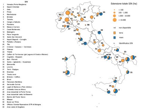
The indicator describes the status of the 42 Contaminated Sites of National Interest (SIN), which together cover 148,594 hectares of land surface (0.49% of the Italian territory) and 77,136 hectares of marine areas. This issue affects all Italian regions, except Molise. As of 30 June 2024, for 65% of the total area of the 36 SINs under consideration, information is available on the progress of the procedures: characterization has been completed for 59% of the soils and 55% of the groundwater, while remediation/safety measures have been approved by ministerial decree for 13% of the soil area and 17% of the groundwater. Procedures have been completed for 17% of the soils and 6% of the groundwater. The information provided by the indicator outlines a representative picture of environmental conditions and societal responses in relation to regulatory and sustainability objectives.
ENERGY RESOURCE EXTRACTION SITES: GEOTHERMAL ENERGY
Data aggiornamento scheda:
In Italy, geothermal energy, renewable and sustainable, is concentrated in 10 concessions in Tuscany with 34 plants that, in 2023, produced 5,692 GWh, covering 31% of the regional demand and 70% of Tuscany's renewable energy sources.
The direct uses of geothermal heat (climate control, spa use, district heating) and geothermal heat pumps, about 20,000, are growing but still underutilized compared to Northern European countries. The environmental impact is limited and mitigated by abatement systems (AMIS) and reinjection of fluids. Italian resources, concentrated in the Tuscan-Lazio area, also show potential for recovery of strategic elements such as lithium, crucial for the energy transition.
ENERGY RESOURCE EXTRACTION SITES: OIL AND GAS
Data aggiornamento scheda:
The indicator quantifies fossil fuel mineral resource extraction activities (oil and gas) in Italy, providing data on site locations, production, reserves, and potential environmental impacts. As of 30 November 2024, there are 154 production concessions (55 offshore), 23 exploration permits (6 offshore), and 15 gas storage concessions, mostly concentrated in the Po Valley. Oil production, concentrated in Basilicata (91% of the national total), remains stable, while gas production is declining, with 3 billion Sm³ extracted in 2023. The suspension of exploration activities since 2019 and the introduction of the PiTESAI plan have reduced the number of concessions, thereby mitigating environmental impact. Italy's proven reserves amount to 41.8 billion Sm³ of gas (65.2% onshore) and 84.6 million tonnes of oil, mainly in Basilicata and Sicily.
FIRST CATEGORY MINERAL EXTRACTION SITES (MINES)
Data aggiornamento scheda:
The indicator considers extraction sites for first-category minerals, as classified by current regulations, excluding fluid energy sources and mineral and/or thermal water springs, present in the national territory from 1870 to the present. It serves a dual purpose: identifying potential mineral deposits still exploitable with sustainable techniques and locating potential sources of pollution associated with past extraction methods.
Of the 3,016 sites that have been operational in the past 150 years, only 94 currently hold valid concessions, and 76 sites were active in 2020. 562 abandoned or decommissioned mining sites present a medium to high ecological and health risk. Several museum sites have been integrated into the National Network of Mining Museums and Parks (REMI), coordinated by ISPRA.
LAND USE
Data aggiornamento scheda:
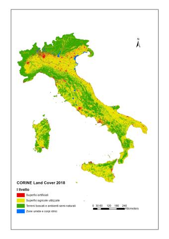
The indicator describes land use (agricultural, urban, industrial or commercial, infrastructure, recreational, natural and semi-natural, water bodies, etc.), reporting the territorial surfaces associated with different classes according to the CORINE Land Cover classification system. Between 2012 and 2018, there was a continued general increase in artificial urban areas, primarily at the expense of agricultural land. In Italy, as in the rest of Europe, cultivated areas show a contraction, linked not only to urbanization processes but also to agricultural land abandonment.
SOIL DEGRADATION
Data aggiornamento scheda:
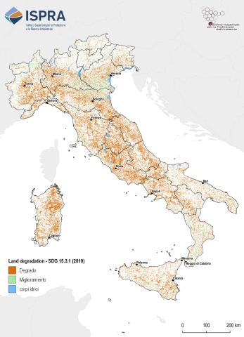
Soil degradation refers to the reduction in the biological productivity of soil resources. This process is often intrinsically linked to biodiversity loss and the impacts of climate change. Assessing soil degradation requires considering multiple interdependent factors, each contributing differently to the phenomenon.
In recent years, Italy has participated in the pilot project on Land Degradation Neutrality (LDN), promoted by the United Nations Convention to Combat Desertification (UNCCD), and in the LDN Target Setting Programme, which supports countries in identifying voluntary LDN targets and defining associated measures to achieve Sustainable Development Goal (SDG) 15.3. This goal is monitored through the "Proportion of degraded land over total land area" (SDG Indicator 15.3.1).
For the assessment of this indicator in Italy, three sub-indicators proposed by UNCCD under the LDN framework have been adopted:
- Land cover change
- Soil productivity index
- Soil organic carbon content
Additionally, further indices and parameters relevant to the Italian context and available at the national level have been considered. The results show that in 2019, the proportion of degraded land in Italy, excluding water bodies, was 17.4%, according to the UNCCD methodology. Furthermore, nearly 56,000 km² (approximately 18.5% of the national territory) experienced increased degradation between 2006 and 2019.
SOIL ORGANIC CARBON AND IMPACT OF SOIL CONSUMPTION
Data aggiornamento scheda:
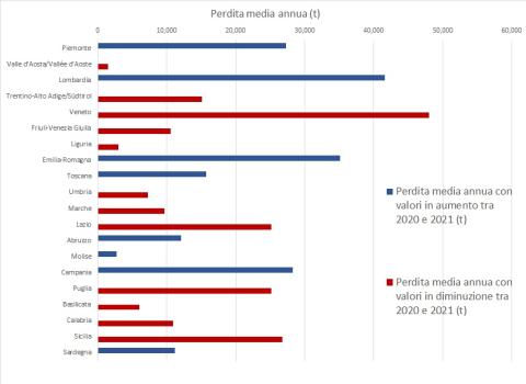
The sequestration and storage of carbon constitute a regulatory service provided by various terrestrial and marine ecosystems due to their ability to capture greenhouse gases. This capacity varies in magnitude depending on the natural state of the ecosystem considered. This service contributes to global climate regulation and plays a crucial role in climate change mitigation and adaptation strategies. Among all terrestrial ecosystems, natural and semi-natural forests have the highest carbon sequestration potential. In the soil pool, in particular, organic carbon accounts for approximately 60% of the organic matter present and performs an essential positive function on many soil properties. Based on the mapping carried out within the GSP (Global Soil Partnership - GSOC map) for the soil reservoir, data from the National Inventory of Forests and Carbon Reservoirs (INFC), and information on land cover and soil consumption from ISPRA cartography, this indicator provides an estimate of the quantities of Soil Organic Carbon contained in the four pools of Italian soils and the variation determined by soil consumption during the periods 2012-2020 and 2012-2021. The estimated stock for 2012 was over 2.6 billion tons, a value that by 2021 had been reduced by over 3.2 million tons, with a continuous decline and an increasing annual loss rate in eight out of twenty regions.