Roberta Carta, Fiorenzo Fumanti, Teresa Lettieri
The Geological Mapping Project of Italy at 1:50,000 scale (CARG Project) aims to achieve full coverage of the Italian territory through the production of the 634 map sheets that make up the Geological Map of Italy at 1:50,000 scale.
The indicator is based on the Geological Mapping Project (CARG Project) carried out by ISPRA, which aims to achieve full coverage of the Italian territory through the production of the 634 sheets composing the Geological Map of Italy at 1:50,000 scale.
Data collected within the framework of the CARG Project are digitised at a scale of 1:25,000 and constitute the national geological database.
The CARG Project is implemented in collaboration with the Regions and Autonomous Provinces, the National Research Council (CNR), and universities, and is coordinated by the Department for the Geological Survey of Italy (SGd’I) – ISPRA, acting as the national cartographic authority (Law 68/1960).
Regions and Autonomous Provinces may provide, through possible financial contributions, additional resources necessary for the production of geological map sheets. Geological surveys are carried out according to guidelines specifically developed and valid at the national scale.
For the sake of completeness, geological map sheets at 1:50,000 scale produced prior to the CARG Project have also been taken into account.
The indicator provides data on the progress status of official geological mapping updated at the 1:25,000 scale.
To support the advancement of geological knowledge of the Italian territory through mapping, which is a fundamental tool for all activities related to spatial planning, risk forecasting and prevention, and natural resource management.
There is no specific regulatory framework against which to assess the state of progress. The activities, funding, and funding allocation mechanisms of the CARG Project were defined by Law 67/1988 with CIPE Resolution of 5 August 1988, by Law 305/1989 with CIPE Resolution of 3 August 1990, which framed the Project within the “Three-year Environmental Protection Programme”, and by Laws 438/1995, 226/1999, and 365/2000.
The 2019 Budget Law (Law 160/2019) allocated €15 million to ISPRA for the 2020–2022 three-year period; the 2020 Budget Law (Law 178/2020) allocated an additional €10 million for 2021–2022; and the 2021 Budget Law (Law 234/2021) allocated a further €6 million for 2022.
Finally, Budget Law No. 197/2022 allocated €52 million for the 2023–2025 three-year period, and Budget Law No. 207/2024 allocated €1 million for each year from 2025 to 2027.
ISPRA - Series III Notebooks of the Geological Survey of Italy - Guidelines for the creation of the Geological and Geothematic Map at the 1:50,000 scale - ISPRA - Notebooks from n. 1/1992 at n. 15/2022.
Dependence on the progress of the Project and the availability of dedicated resources.
Autonomous Provinces
Regions
Universities
National
1988- December 2025
The indicator quantifies the official geological maps produced by the implementing bodies (territorial authorities, CNR bodies, university departments and institutes, Regions and Autonomous Provinces) on the basis of the Guidelines developed by the Geological Survey of Italy of ISPRA.
Geological survey data, carried out at scales of 1:10,000 and 1:25,000, are digitised at a scale of 1:25,000 and constitute the national geological database.
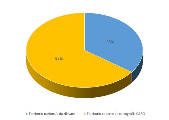
Geological map sheets currently under production and those already completed cover approximately 65% of the national territory (Figure 3), as elaborated according to CARG criteria, which constitute the reference basis for the production of official 1:50,000 scale sheets.
During the implementation of the Project, delays occurred but were subsequently offset by an acceleration in recent years, leading to an increase in national territorial coverage compared to that achieved by sheets funded prior to the 2020–2022 Budget Laws.
With the new funding provided by these laws, survey activities have resumed, making it possible to reverse the negative trend that had persisted since 2004.
| Data |
|---|
Thumbnail
Headline
Figure 1: Extension of the area covered by official geological mapping at 1:25,000 scale (December 2025) Data source
ISPRA |
Thumbnail

Headline
Figure 2: Percentage of regional territory covered by official geological mapping at 1:25,000 scale (December 2025) Data source
ISPRA |
Thumbnail
Headline
Figure 3: Territory covered by official geological mapping at 1:25,000 scale (December 2025) Data source
ISPRA |
Thumbnail
Headline
Figure 4: Overall state of implementation of the official geological mapping at scale 1: 50,000 (December 2025) Data source
ISPRA |
Thumbnail
Headline
Figure 5: State of implementation of the geological sheets at 1:50,000 scale of the CARG Project (2025) Data source
ISPRA |
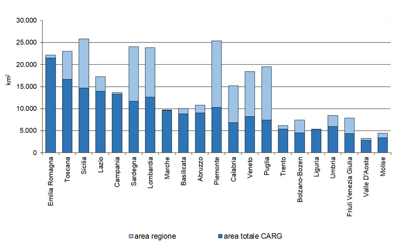
Figures 1 and 2 show that Marche, Campania and Emilia-Romagna are now close to achieving full coverage of their territory through geological mapping at an adequate scale, also aimed at supporting planning activities.
The state of progress in other regions is less advanced, with fewer than half of them having official cartographic coverage below 50%.
Figures 1 and 2, while considering only areas actually surveyed and for which at least the original author’s materials are available, also include sheets currently under production, regardless of whether the corresponding 1:50,000 scale sheets have been completed. As shown in Figure 3, just under half of the national territory still remains to be surveyed.
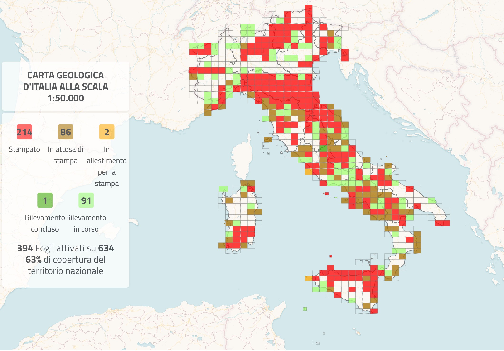
Prior to Law 160/2019, which led to the resumption of the Project, 254 geological sheets had been completed or were nearing completion within the CARG Project. These are supplemented by 5 sheets fully funded by certain regions (such as Puglia, Lazio and Liguria) and 22 geological sheets produced by the Geological Survey of Italy outside the CARG Project, for a total of 281 geological sheets at 1:50,000 scale.
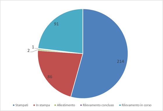
With the funding provided by the last four Budget Laws (2020, 2021, 2022, 2024), 113 new sheets have been launched, of which 26 have been completed. In addition, one geological sheet fully funded by the Lazio Region has been initiated, bringing the total to 394 sheets out of an overall total of 634.
Of all activated sheets, 302 have been completed: 214 have been printed, 86 are in the printing phase, and 2 are being prepared for printing (Figures 4 and 5).
The area covered by CARG geological mapping accounts for approximately 65% of national cartographic coverage.