Sabrina Agnesi, Susanna D'Antoni, Stefania Ercole, Silvia Properzi
The European Commission adopted the EU Biodiversity Strategy for 2030 (EBS 2030, COM(2020) 380 final), which calls on Member States to protect at least 30% of national land territory and 30% of marine areas, with at least one third of these areas under strict protection. These objectives have been incorporated into the Italian National Biodiversity Strategy for 2030 (NBS 2030).
This indicator integrates spatial data relating to the main biodiversity protection systems in Italy (protected areas and the Natura 2000 Network). It calculates the extent of Italian territory currently protected on land and at sea, assesses changes from 1991 to 2024, and shows the gap between the percentage of protected land and marine areas and the 30% target set by the EBS 2030.
After removing overlaps between protected areas and Natura 2000 sites, national protected coverage currently amounts to approximately 4,071,482 hectares at sea, corresponding to 11.6% of Italian territorial waters and the Ecological Protection Zone (EPZ), and about 6,532,887 hectares on land, corresponding to 21.7% of Italian territory. The extent of overlapping areas—those falling both within a protected area and a Natura 2000 site—has increased over time, reaching 893,839 hectares at sea and 2,447,065 hectares on land in 2024. Trends show that the national percentage of protected surface has stabilised since 2006 for marine areas and since 2011 for terrestrial areas. To achieve the 30% target set by the EBS 2030, an additional gap of about 18% of marine surface still needs to be protected (around 6,600,000 hectares), along with 8% of terrestrial surface (around 2,500,000 hectares).
The indicator analyses the surface area of Italian territory currently protected on land and at sea in relation to the strategic biodiversity protection objectives set for 2030 at both European (EBS 2030) and national (NBS 2030) level. It considers the surface areas of protected areas included in the Nationally Designated Areas (NatDA) database—Europe’s database of nationally designated protected areas—and the surfaces of Natura 2000 sites, namely Sites of Community Importance / Special Areas of Conservation (SCIs/SACs) and Special Protection Areas (SPAs). In particular, land and marine surface area and percentages are calculated separately for NatDA and the Natura 2000 Network, as well as net of overlaps between the two categories of protected sites. These data are updated every five years from 1991 to 2021 and, since the most recent update, annually, in order to progressively assess progress towards the targets of the two Biodiversity Strategies for 2030. Marine surface refers to territorial waters and the Ecological Protection Zone (EPZ).
It should be recalled that the Natura 2000 Network comprises SCIs/SACs and SPAs designated under the Habitats and Birds Directives, while NatDA includes areas listed in the Official List of Protected Areas (EUAP, 6th update, 2010), supplemented with nationally designated protected areas established from 2010 onwards: Pantelleria Island National Park, Tresero–Dosso del Vallon State Nature Reserve, Capo Testa – Punta Falcone Marine Protected Area, Capo Milazzo Marine Protected Area, Portofino National Park, Capo Spartivento Marine Protected Area. In addition, the Val Grande National Park was expanded.
To quantify the percentage of land and marine surface covered by protected areas, net of spatial overlaps between protected areas (NatDA) and Natura 2000 sites, and to assess its temporal variation, also in order to highlight the gap with respect to the 30% target of protected surface (relative to national territory) established by the EBS 2030.
Directive 79/409/EEC “Birds” (subsequently repealed and completely replaced by 2009/147/EC which maintains its fundamental objectives), implemented in Italy with Law no. 157 of 11/02/1992;
Directive 92/43/EEC “Habitats”, implemented in Italy with Presidential Decree 357/97 modified and integrated by Presidential Decree 120/2003;
L 979/82 (Provisions for the defense of the sea);
L 127/85 (Ratification and execution of the Protocol relating to specially protected areas of the Mediterranean);
L 394/91 (Framework Law on Protected Areas) and subsequent amendments;
EUAP, 6th update (DM 27.04.2010 GU n. 125 of 31.05.2010)
DM 02/12/2010 Establishment of the State Nature Reserve called “Tresero-Dosso del Vallon”;
Presidential Decree 07/28/2016 Establishment of the “Island of Pantelleria” National Park and the “Island of Pantelleria” National Park Authority;
Ministerial Decree 17/05/2018, n. 102. Establishment of the marine protected area «Capo Testa - Punta Falcone».
Ministerial Decree 26/11/2018, n. 153. Approval of the disciplinary regulation of the marine protected area «Capo Milazzo» published in the Official Journal no. 55 of 6.3.2019;
Ministerial Decree 10/10/2023 n. 331 Establishment of the Portofino National Park, published in the Official Gazette n. 246 of 23 of 10.20.2023;
Presidential Decree 18/07/2023, published in the Official Journal no. 238, of 11.10.2023. Expansion of the Val Grande National Park;
DM n. 440 of 22 December 2023, Establishment of the Capo Spartivento Marine Protected Area, published in the Official Journal no. 245 of 18 October 2024;
Establishment of the ecological protection zone of the north-western Mediterranean, the Ligurian Sea and the Tyrrhenian Sea pursuant to article 1 of law 8 February 2006, n. 61 and with Regulation establishing ecological protection zones of the north-western Mediterranean, the Ligurian Sea and the Tyrrhenian Sea (11G0252) (GU General Series n.293 of 17.12.2011)
DM n.252 of 03/08/2022 for the Adoption of the National Strategy for Biodiversity to 2030
The protected areas established on the basis of framework law no. 394/1991 have the aim of guaranteeing and promoting the conservation and valorisation of the country's natural heritage (art. 1) and of subjecting the territories in which species and habitats of conservation interest, geological and paleontological formations, panoramic values, etc., are present to a protection regime, especially if vulnerable (art. 2), depending on the categories to which they belong. Law 394 provides that environmental management or restoration methods suitable for achieving integration between man and the natural environment and reducing the loss of biodiversity are applied in protected areas. 394/1991 integrates and updates what is already provided for in Title V of L 979/1982 regarding the establishment and management of marine protected areas.
The Natura2000 Network is an ecological network spread across the entire territory of the European Union made up of Special Protection Areas (SPAs) established pursuant to the Birds Directive and Sites of Community Interest (SCI), subsequently designated as Special Areas of Conservation (SAC), identified pursuant to the Habitats Directive.
The new European Strategy for Biodiversity has indicated numerous objectives for Member States to be achieved by 2030, including the expansion of protected areas in the EU, calling for at least 30% of the land surface and 30% of the sea to be protected and for at least a third of protected areas to be strictly protected.
Agnesi S., Annunziatellis A., Chaniotis P., Mo G., Korpinen S., Snoj L., Tunesi L., Reker J., 2020. Spatial Analysis of Marine Protected Area Networks in Europe’s Seas III. ETC/ICM Technical Report 3/2020. https://www. eionet. europa. eu/etcs/etc-icm/products/etc-icm-report-3-2020-spatial-analysis-of-marine-protected-area-networks-in-europe2019s-seas-iii
Agnesi S., Mo G., Annunziatellis A., Chaniotis P., Korpinen S., Snoj L., Globevnik L., Tunesi L., Reker J., 2017. Spatial Analysis of Marine Protected Area Networks in Europe’s Seas II, Vol. A, 2017, ed. Künitzer A., ETC/ICM Technical Report 4/2017, Magdeburg: European Topic Center on inland, coastal and marine waters, 41 pp. https://www. eionet. europa. eu/etcs/etc-icm/products/etc-icm-reports/spatial-analysis-of-marine-protected-area-networks-in-europe2019s-seas-ii-volume-a-2017
EC, 2020. EU Biodiversity Strategy for 2030. Bringing nature back into our lives. Brussels, 20.5.2020, COM(2020) 380 final. https://eur-lex. europa. eu/legal-content/IT/TXT/HTML/? uri=CELEX:52020DC0380&from=EN
D'Antoni S., 2022. Protected areas, a pillar of conservation. ECOSCIENCE Number 2 Year 2022.
D'Antoni S., Augello R., Bagnaia R., Ceralli D., Properzi S., 2023. Criteria for identifying areas to be protected to achieve the objectives of the European biodiversity strategy for 2030. Reticula n. 32/2023
EEA, 2015. Spatial analysis of Marine Protected Area Networks in Europe´s seas. EEA Technical report, 17/2015. http://www. eea. europa. eu/publications/spatial-analysis-of-marine-protected
IUCN-WCPA Task Force on OECMs, 2019. Recognizing and reporting other effective area-based conservation measures. Gland, Switzerland: IUCN. ISBN: 978-2-8317-2025-8 (PDF). DOI: https://doi. org/10.2305/IUCN. CH.2019. PATRS.3. en
MiTE, 2022. National Strategy for Biodiversity to 2030. Consolidated text . Ministry of Ecological Transition (MiTE), Directorate General for Natural Heritage and the Sea, Division III - Biodiversity Strategies, 25 July 2022.
Among the limitations, it should be noted that the Official List of Protected Areas (EUAP) has not been updated since 2010. The data relating to the protected areas included in EUAP has been updated with regard to protected areas established at national level (National Parks, State Nature Reserves, Marine Protected Areas), while for regional areas the approval of the new EUAP must be awaited.
To define the changes in the protected surface area, the calculation of the surfaces was carried out at 5-year intervals (from 1991 to 2021), selecting the protected areas designated in each time interval based on the year of the designation act. In this procedure, any subsequent acts relating to changes to the perimeter of the individual protected site are not perceptible. Therefore, if a site has undergone an expansion or reduction in surface area over the years, this specific change is not detected.
In the calculation of national surfaces, OECMs could also be considered, i. e. Geographically defined areas which, although not strictly protected areas, are managed in such a way as to ensure the effective and long-lasting conservation of biodiversity in situ (IUCN-WCPA, 2017). The examination of the types of areas that can appropriately fall into the OECM category is still underway, therefore, it was not possible to include them in the analysis.
Update of the EUAP. Inclusion of OECM data. Analysis of protected surfaces at regional/autonomous province scale. Calculation of the percentage of strictly protected areas.
ISPRA
ISTAT
MASE (Ministry of the Environment and Energy Security)
Official List of Protected Areas (EUAP, 2010) published in the Official Journal
Common Database on Designated Areas (CDDA) published on the website of the European Environment Agency which has now merged into Nationally Designated Areas (NatDA ) published on the website of the European Environment Agency ( https://www. eea. europa. eu/data-and-maps/data/nationally-designated-areas-national-cdda-17)
Natura2000 database published on the MASE website https://www. mase. gov. it/pagina/sic-zsc-e-zps-italia
National
1991-2024
Data used for this indicator derive from two official databases produced by MASE: the Natura 2000 database and the EUAP (6th update, 2010), supplemented with nationally designated protected areas (terrestrial and marine) established after 2010. The EUAP, integrated with these nationally designated areas, is incorporated into the Common Database on Designated Areas (CDDA), now NatDA, which is transmitted annually by ISPRA to the European Environment Agency (EEA). OECMs are not included in surface calculations as they have not yet been defined at national level.
For Natura 2000 sites, data from the latest transmission to the European Commission by MASE in December 2024 were used, while NatDA data derive from the March 2025 transmission referring to 2024. Both spatial and tabular data (shapefiles and related attribute tables) were used. All spatial data were projected in the ETRS89/LAEA coordinate reference system.
The analysed areas fall into three categories: land-only sites, marine-only sites, and mixed land–sea sites. An initial classification was performed using tabular attributes indicating terrestrial or marine designation. Subsequently, for mixed sites, surfaces were split by clipping spatial layers along the ISPRA (SINA) coastline. The marine reference surface consists of territorial waters (IIM source) and the Ecological Protection Zone. Once land–sea separation was obtained, surface analysis was conducted separately.
The first step involved calculating protected marine and terrestrial surfaces for protected areas and Natura 2000 sites separately and net of overlaps. Subsequently, total surface generated by summing the two systems was calculated net of overlaps.
A further analysis grouped protected sites by time periods. Five-year intervals from 1991 to 2021 were analysed, except for the final update to 2024 (after three years). Starting from the 2024 database update, data were reconstructed retroactively by subtracting sites designated after each reference year. For EUAP/NatDA, the year of designation was considered, while for Natura 2000 sites the year of submission to the European Commission was used; for “C” sites (coincident SPAs and SCIs/SACs), the first year of submission was used.
Once protected surface net of overlaps had been obtained, the percentage of protected territory relative to national territory was calculated. Marine surfaces refer to territorial waters and the EPZ, while terrestrial surfaces were calculated using ISTAT area data (2023 update).
Status is rated as medium because, despite the increase in protected areas since 1991, achieving the 30% national protection target set by the EBS 2030 still requires closing a gap of about 18% for marine areas (around 6.5 million hectares) and 8% for terrestrial areas (around 2.5 million hectares). Identifying these areas will require a complex process involving many stakeholders, primarily MASE, regions and autonomous provinces.
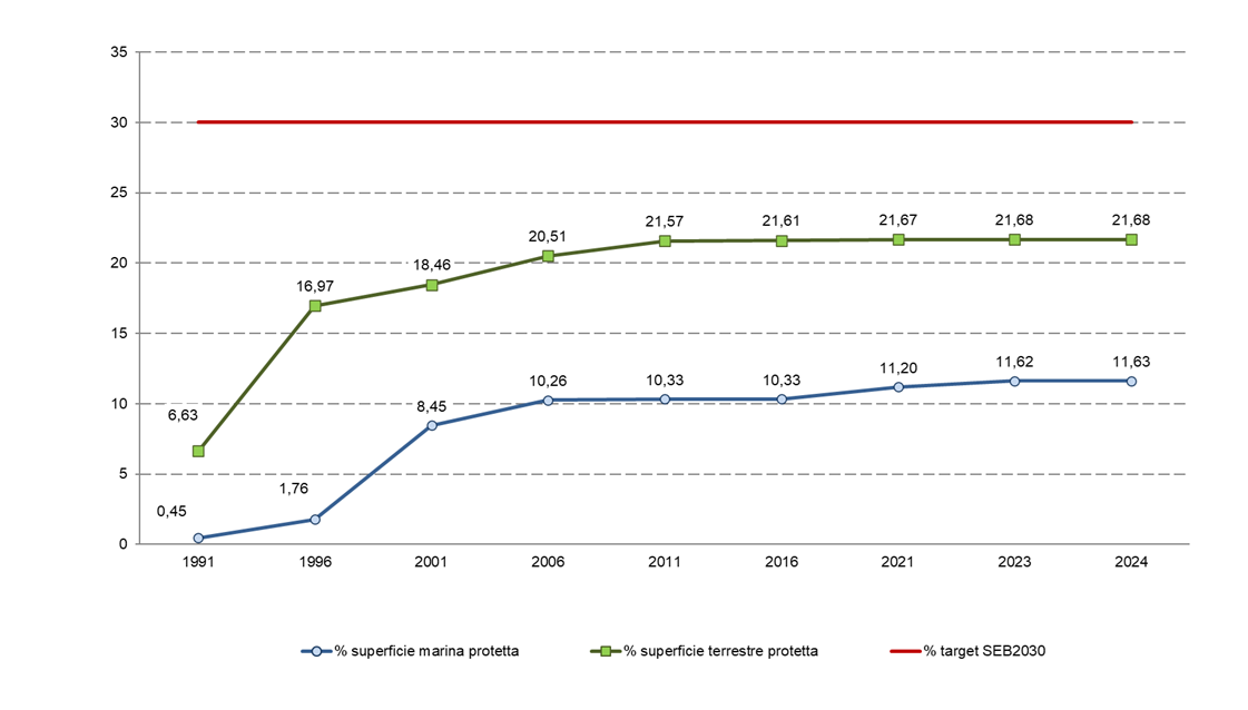
Overall, the trend can be considered stable, as the percentage of protected marine surface stabilised at about 10.3% from 2006, rising to 11.6% in 2024, while terrestrial protected surface stabilised at 21.6% from 2011, with a slight increase to 21.7% in 2023.
| Allegati |
|---|
Titolo
Table 1 - Areas in hectares and percentage of the national marine and terrestrial territory protected by Natura 2000 sites (updated 2024) and protected areas included in NatDA (updated 2024). The table shows the total values of the two types of protected sites, their overlap, and the total net of overlaps Fonte
ISPRA processing of MASE data |
Thumbnail
Titolo
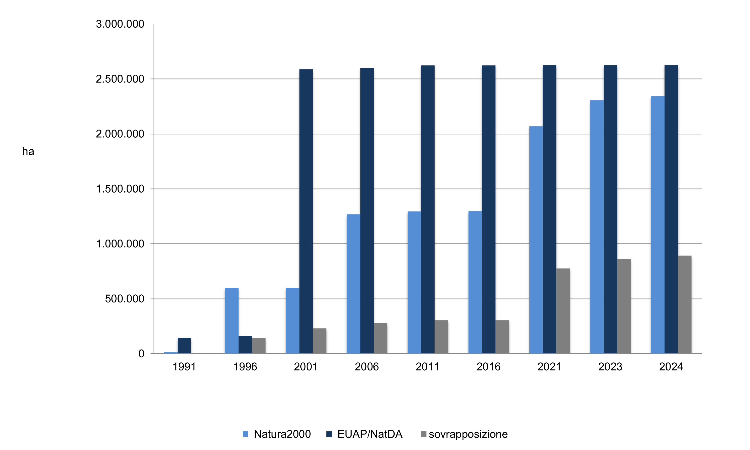
Figure: 1 Marine areas within territorial waters and the ZPE protected by Natura 2000 sites (updated 2024) and protected areas included in the CDDA (updated 2024) and their overlap Fonte
ISPRA processing of MASE data Note
With regard to the Marine Mammal Sanctuary area, only the part falling within national waters was considered, as reported in the NatDA |
Thumbnail
Titolo
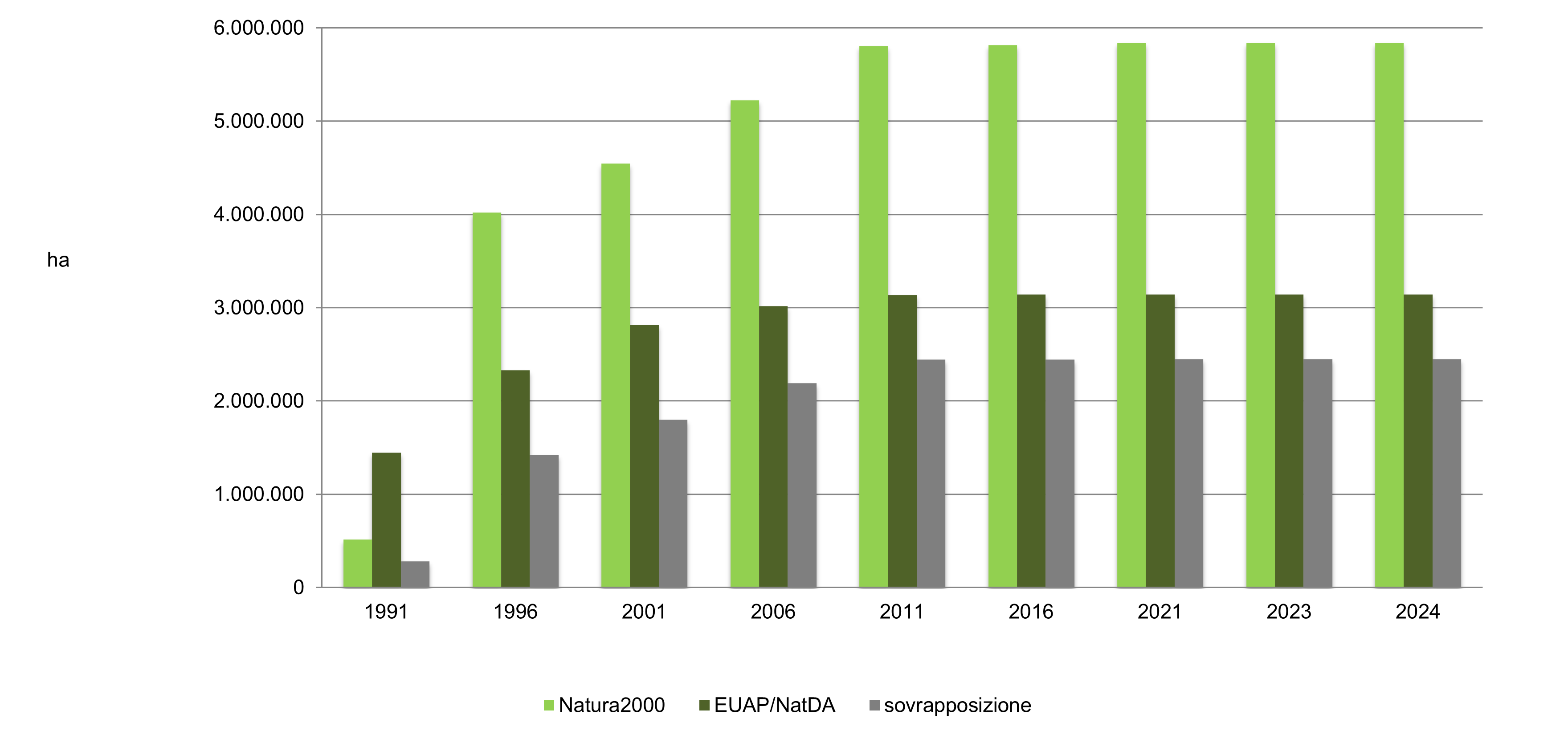
Figure 2: Land areas protected by Natura 2000 sites (updated 2024) and protected areas included in the NAtDA (updated 2024) and their overlap Fonte
ISPRA processing of MASE data |
Thumbnail
Titolo
Figure 3: Percentage of protected land and sea areas, net of overlaps, from 1991 to 2024 and percentage forecast by the European Biodiversity Strategy target for 2030 Fonte
ISPRA analysis based on MASE data Note
le superfici marine protette sono calcolate all'interno delle Acque Territoriali e della ZPE italiane |
Current analyses show that national protected coverage, net of overlaps between protected areas and Natura 2000 sites, amounts to approximately 4,071,482 hectares at sea (11.63% of Italian territorial waters and the EPZ) and 6,532,887 hectares on land (21.68% of national territory), still far from the 30% EBS target. The extent of overlapping areas has progressively increased over time, reaching 893,839 hectares at sea and 2,447,065 hectares on land in 2024.
The temporal evolution of marine protection shows a constant increase in Natura 2000 marine surfaces, especially in the last five years, during which surface nearly doubled (from 1,296,715 hectares in 2016 to 2,342,920 hectares in 2024). Conversely, the surface of Marine Protected Areas remained almost unchanged since 2001, despite the establishment of three new MPAs in the last five years (Capo Testa – Punta Falcone, Capo Milazzo, Capo Spartivento), with total surface increasing only marginally from 2,624,326 to 2,628,783 hectares. Overlaps increased mainly due to the rise in Natura 2000 sites.
As for terrestrial protected areas, surface has remained almost unchanged since 2006 for both Natura 2000 sites and protected areas, with the exception of the Tresero–Dosso del Vallon State Nature Reserve (2010) and the Pantelleria National Park (2016), which had limited impact on overall surface (from 3,028,788 hectares in 2006 to 3,142,532 hectares in 2024). The establishment of Portofino National Park in 2023 did not increase terrestrial protected surface, as its perimeter coincides with the former regional park. At regional level, no EUAP updates have been made since 2010, making it currently impossible to assess variations in surface.