Maria Luisa Cassese, Filippo D’Ascola, Valeria Pesarino, Andrea Salmeri
To contain the erosion of the coasts and the damage produced by the storms over the years, numerous interventions have been carried out along the Italian coasts, aimed at protecting the assets and infrastructure present in the immediate hinterland and the restoration of the backward beaches. The indicator provides an estimate on a national and regional basis of the protected coast with rigid works, the measure is representative of both the fragility of the coastal environments of the country and the management and protection costs from the hydrogeological instability of coastal areas.
18% of the Italian coasts, equal to about 1,520 km, are protected with defense works and the action to combat erosion does not stop; from the relief of the state of the coast to 2020 it appears that between 2008 and 2020 new works have been carried out to protect a further 200 km of coastline.
Italian coasts are subject to intense erosive phenomena with retreat of the shoreline and reduction of the breadth of the beaches. The action of the sea, especially in storm events, undermines the safety of roads and railways and undermines socio-economic activities, even of a bathing tourist type, which develop along the coast. The frequency of damage caused by storm surges and the increasing exploitation of the coastal territory induce the bodies responsible for planning and implementing a growing number of coastal defense interventions. In Italy, Legislative Decree no. 112 of 31 March 1998, in implementation of Chapter I of Law No. 59 of 15 March 1997, confers functions on the regions in the field of planning, planning, integrated management of coastal defense interventions and coastal settlements (Article 89 paragraph 1 letter h), leaving to the State the tasks of national importance relating to the general guidelines and criteria for the defense of the coasts (Article 88 paragraph 1 letter aa).
The solutions of protection of the coasts and of containment of the instability for erosion adopted over the years by the administrations are mainly interventions with “rigid” coastal defense works, that is, fixed structures capable of interfering with the wave motion and limiting the harmful effects of the storms, and in some cases interventions with “soft” works, which provide for interventions to restore the beaches mainly through artificial repasting and recovery of the dune system.
The “rigid” coastal defense works are a heterogeneous set of structures that, according to the characteristics of form and positioning, interact with the coastal dynamics. In principle, the longitudinal defense works allow the shore to attenuate the action of the waves on the coast and to limit the instability of the coasts during the storm events, a result often obtained with the installation of artificial cliffs or islets placed at sea a few tens of meters from the shore; while transverse works the shoreline, such as brushes and arms armed at the river foci, allow to change locally the dynamics of the beaches. To counteract the aggressive action of the sea, combined solutions of transverse and longitudinal structures are also adopted, the shore, that is mixed works, and structures grazing the shore, as an extreme bulwark to protect artifacts and areas of interest located near the shore.
The indicator provides the estimate on a national and regional basis of the protected coast with defense works.
The indicator is the synthesis of the analysis of the stretches coast protected by coastal defense works, depending on the type of work, the dimensional parameters and the distance from the shore; the measure, expressed in kilometers of coast protected by the works, is obtained through spatial elaborations of the catalog of rigid defense works carried out along the Italian coast with the respective sectors of attenuation of the wavering to coast.
On the basis of the cartographic survey of the state of the coasts and the maritime works to 2020, the estimate of the protected coast is provided to 2020, comparing it with the corresponding published estimates for the territorial coverage of 2000 and 2006.
Arrange synthetic information on the actions put in place for the containment of the hydrogeological instability of the coastal areas of the country.
The indicator is a representative parameter of both the vulnerability of the coastal areas of the country and the management costs incurred for the protection of coasts and socio-economic structures and activities that develop near the coast. It can also be to support the evaluation of the effectiveness of the protective interventions carried out, which can be seen over time with the effect of stabilizing and restoring protected lithoes.
Legislative Decree no. 112 of 31 March 1998, in implementation of Chapter I of Law No. 59 of 15 March 1997, confers the functions and administrative tasks of the State to the regions in the field of protection and observation of coastal areas (Article 70 paragraph 1 letter a) and programming functions, planning, integrated management of coastal and coastal residential interventions (Article 89 paragraph 1 letter h), leaving the State with the general important tasks related to the general guidelines. The indicator is functional to the evaluation of hydrogeological instability in a coastal environment, to the definition of general guidelines and to reports on the state of implementation of the numerous directives that recall the protection of coastal areas.
F. D'Ascola, M. L. Cassese, N. Lugeri, V. Pesarino, A. Salmeri. 2022. From coastline to backshore: a Geodatabase for the monitoring and analysis of the state of the Italian coasts. In: L. Bonora, D. Carboni, M. De Vincenzi, G. Matteucci (edited by), Series of Proceeding of Nineth International Symposium “Monitoring of Mediterranean Coastal Areas. Problems and Measurement Techniques”. Livorno (Italy) June 2022. Published by Firenze University Press. In Press.
F. D'Ascola, A.-L. Beck, M. L. Cassese, M. Jones, N. Lugeri, V. Pesarino, A. Salmeri, M. A. Taji. 2022. Monitoring of the evolution of “barene” borders and the safeguard of the Venice Lagoon morphology: a contribution from the Coastal Change from Space project results. In: L. Bonora, D. Carboni, M. De Vincenzi, G. Matteucci (edited by), Series of Proceeding of Nineth International Symposium “Monitoring of Mediterranean Coastal Areas. Problems and Measurement Techniques”. Livorno (Italy) June 2022. Published by Firenze University Press. In Press.
MATTM-Regioni, 2018. Linee Guida per la Difesa della Costa dai fenomeni di Erosione e dagli effetti dei Cambiamenti climatici. Versione 2018 - Documento elaborato dal Tavolo Nazionale sull'Erosione Costiera MATTM-Regioni con il coordinamento tecnico di ISPRA, 305 pp
The limit is represented by the non-accounting of the stretches of coast protected by reproaches
ISPRA
The data on coastal defense works, processed by ISPRA, can be consulted on the ISPRA Coasts Portal at the link: https://sinacloud.isprambiente.it/portal/apps/sites//coste. In addition, in the Data section of the Coasts Portal it is possible to download the information layers for the entire national settling and for all the time series developed by ISPRA in geopakage format, which can be used through the main GIS tools.
National; Coastal Regions
2000-2006-2020
For the calculation of the indicator, a coastal belt data acquisition methodology based on the photointerpretation and classification of information detectable from mosaics of horizontal orthophotos of trivial colour at sub-meter spatial resolution is defined. For the cartographic representation and description of the geomorphological characteristics of the coasts and the artificial structures made along the shore – ports, coastal protection works and artifacts – classification standards and procedures have been defined for the determination of the main dimensional parameters. The methodology of importance and elaboration, applied to the available national territorial coverage, has allowed the generation of a historical series on the state of the Italian coasts and a catalog of maritime works and coastal protection, updated with the newly created works and variants of the pre-existing works; historical series that constitutes the database for the calculation of state indicators and changes in the coastal area.
The reference sources used for the cartographic survey of basic data are for 2020 the mosaics of the color orthophotos available on Google platforms, for 2006 and 2000 the mosaic of the orthophotos respectively of the flight IT2006 and the flight IT2000, available on the National Cartographic Portal.
The catalogue of the works is composed of all the artifacts made at sea or near the shore visible by the orthophotos, identified by use – port, filled, beaches, piers, coastal defense works. The defense works are classified by type – grazing, cliffs, brushes, islets, mixed works and armed foci, for constructive details – orthogonal, oblique, emerged, submerged, for variants intervened by the last survey – expansion, change of use, disposal, new realization – and are archived with the measurement of main construction parameters – extension and distance from the shore.
The action of interference with the coastal dynamics and attenuation of the wave motion to coast of the coastal protection works varies with the type and position with respect to the shore. The grazing, wall-mounted or thrown-out works of boulders, has assumed to act only on the stretch of coast on which they insist. The cliffs interact on the coast facing the scale, distance and orientation of the work with respect to the shore and the morphological characteristics of the coast underlying the work. Other works, such as brushes and armed mouths, affect the stretches of coast adjacent in proportion to the size of the work and according to the shape and orientation.
For the indicator, a procedure was defined that allowed the identification of the sections of the coast protected by adhering defense works and detached from the shore. The procedure takes into account the type, shape, size of each defense work and its location along the coast.
The delimitation of the sector of interference with the action of the wave motion caused by each work and the aggregation of all the stretches of the coastline underlying the sectors of protection of the works has produced a territorial coverage of the Italian coast protected from the defense works, unless the artificial replenishment interventions.
In Italy about 18% of the coasts, equal to about 1,520 km, is protected with rigid coastal defense works built over the years to contain the failure caused by the storms and the erosion of the coasts.
Coastal accommodation works can be found along all coastal sectors of the country, but the most protected coasts are those where urban centers, road and railway infrastructure and socio-economic activities develop along the coast. These rigid works, today, represent interventions that are carried out in emergency, when the conditions of criticality and danger for things and people do not allow the realization of larger works, aimed at carrying out projects for lasting repasting of the beaches. The persistence of the works carried out in the past and the continuous installation of new interventions correspond to worsening from an environmental point of view: while protecting some of the surroundings, the conditions of the natural circulation of water and sediments along the coast continue to be modified, the chemical-physical and ecological conditions are worsened, the beaches are prevented from regenerating naturally, generating a further loss of the natural balance of the beach system.
The model applied for the surveys of the years 2000, 2006 and 2020 shows a continuous increase in the features affected by the effects of these works, which in 2000 amounted to 1,170 km of coastline (14%), a value increased to 1,314 km (16%) in 2006, while for 2020 the value reached 1,520 km (18%), with a trend, in the twenty-year period, equal to an increase of 29.2%. On the part of the competent administrations, the action to combat the progressive degradation of the coasts using different instruments continues, yet it is still necessary to add rigid coastal defense works, while it is still sporadic the replacement of existing rigid works with other less impactful coastal defense schemes. These works, while defending the territory of the retrobeam, cannot be able to renew the natural balance that preserves and renews the beaches, sometimes being used to the retreat of the coast and the disappearance of entire stretches of beach.
| Allegati |
|---|
Thumbnail
Headline
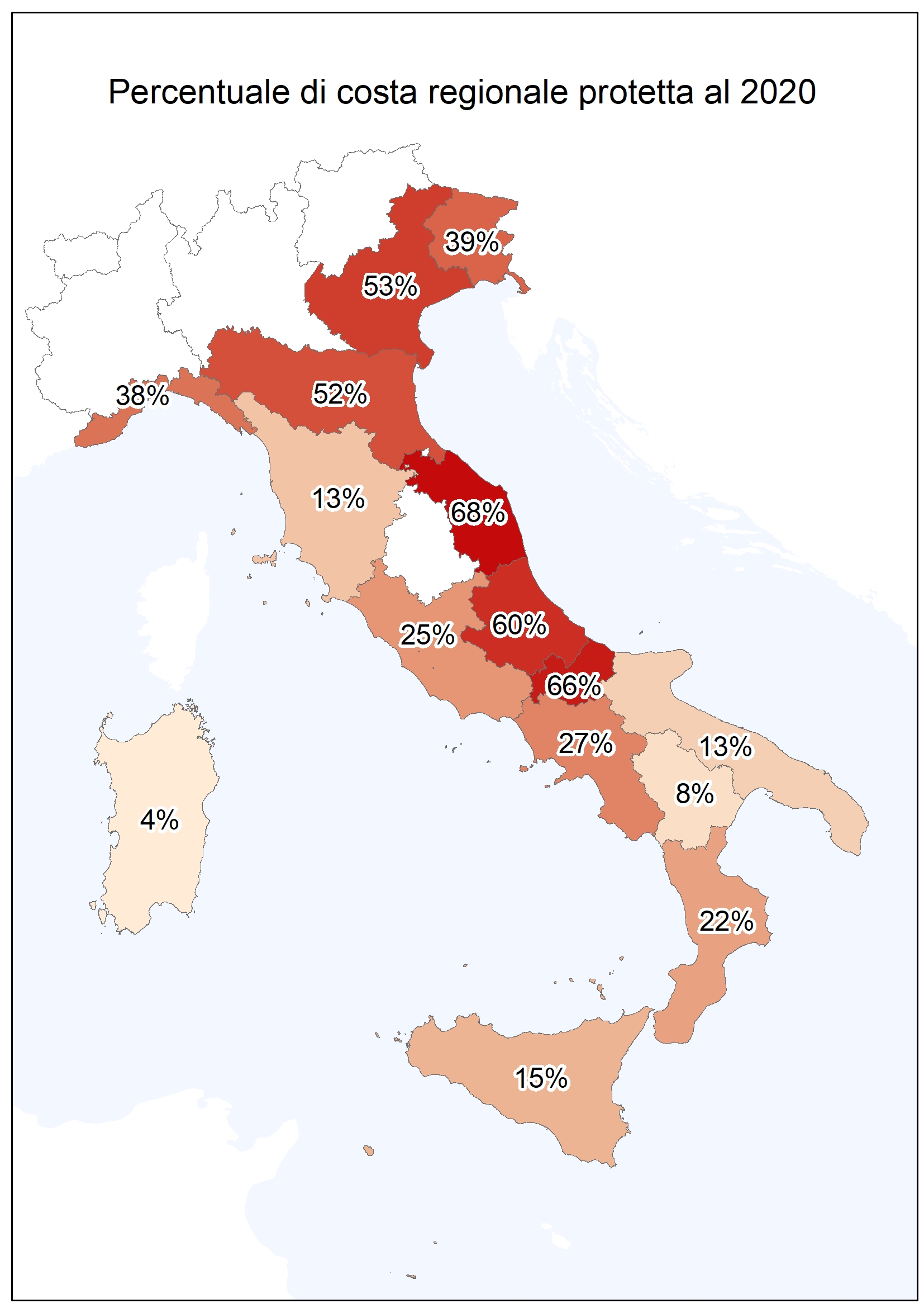
Figure 1: Regional percentage of protected coast at 2020 Data source
ISPRA |
Headline
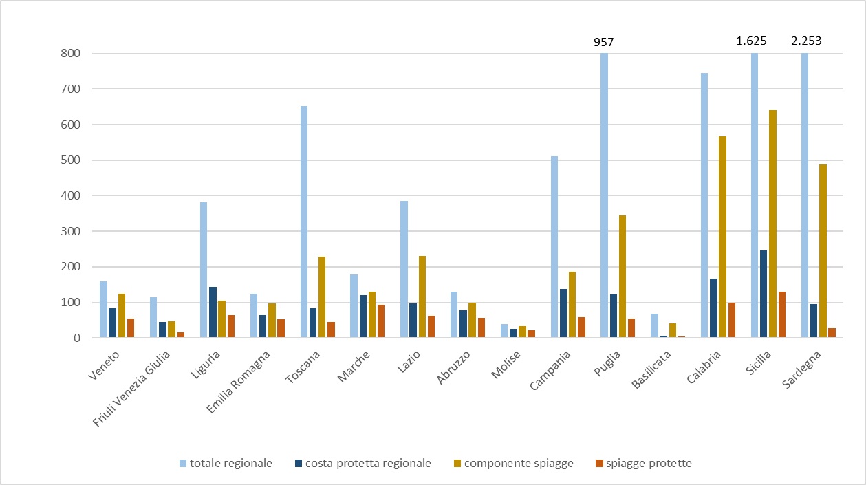
Table 1: Length of regional coast, beaches and related protected components, whether or not divided by type (2000-2006-2020) Data source
ISPRA Data legend
The stretches of coast analyzed have been selected to be comparable in the time series, for this reason the values 2000 and 2006 for the Veneto and Emilia-Romagna regions appear slightly different to those published. |
Headline
Table 2: Changes in length and percentage of protected coastline and relative increase for the years 2000-2006, 2006-2020 and 2000-2020 Data source
ISPRA |
Thumbnail
Headline
Figure 2: Length of the coast and its protected fraction, the beach component and its protected fraction (2020) Data source
ISPRA |
Thumbnail
Headline
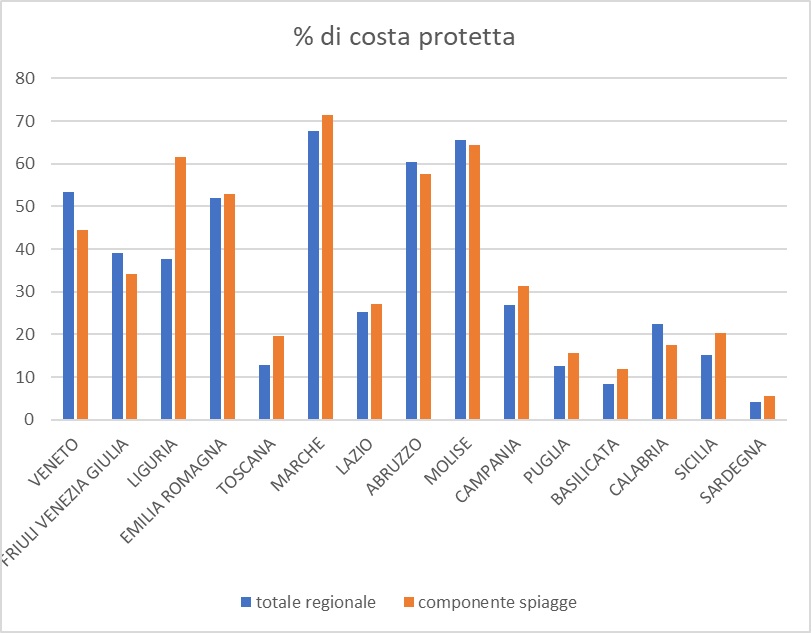
Figure 3: Protected coast share and share of protected beaches component (2020) Data source
ISPRA |
Thumbnail
Headline
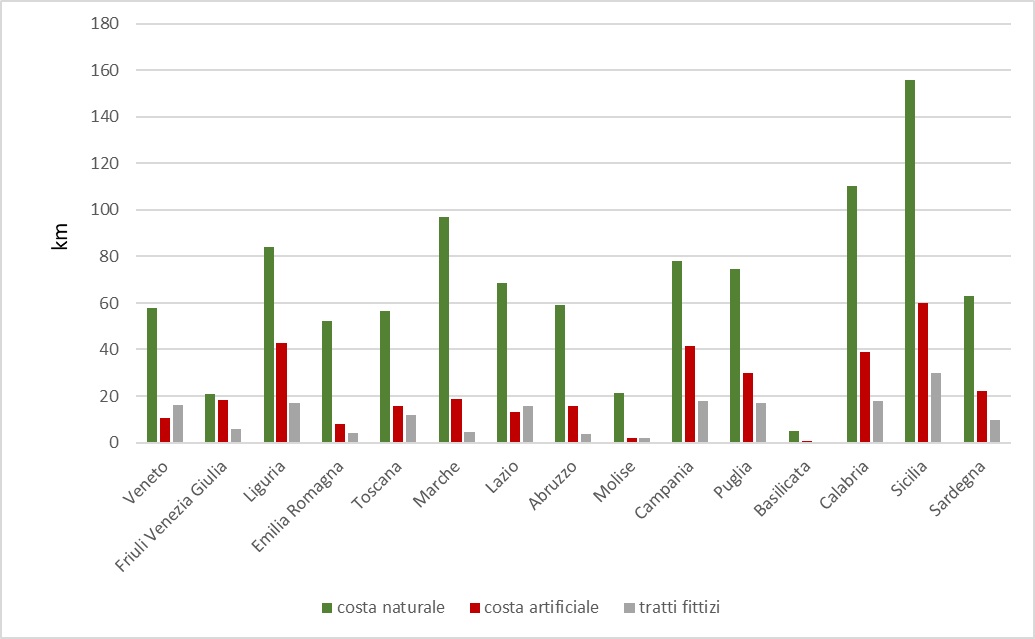
Figure 4: Protected coastline divided by natural, artificial and fictitious strokes Data source
ISPRA |
In Italy about 18% of the coasts, equal to about 1,520 km, is protected with rigid coastal defense works, built over the years to contain the instability and erosion of the coasts.
All regions, competent in the field of coastal strip management, are equipped with plans that include monitoring, planning, maintenance and implementation of solutions aimed at ensuring a level of protection and safety over time to the structures and environmental assets present near the coast.
From Table 1 it emerges that the regions with the highest number of kilometers of protected coast are in order Sicily (245 km), Calabria (167 km), Liguria (144 km), Campania (137 km), Puglia (122 km) and Marche (120 km) but the most defense coasts are those of the Adriatic regions, characterized by mainly low, sandy and tending to be more unstable.
Figure 1 is indicative of the level of protection recorded in the information layers at 2020, without taking into account repeated restoration of the beaches through artificial reproach.
The highest level of protection is recorded along the coasts of the Marche and Molise, with two-thirds of the protected regional coast, followed by Abruzzo, Veneto and Emilia-Romagna, with more than half of the regional coasts protected with rigid works. In Friuli-Venezia Giulia and Liguria more than a third of the coasts are protected, in the remaining regions the percentage of protected coast is much lower.
The beaches represent at national level about 40% of the entire coast, almost 3,400 km, while the rest is represented by natural rocky coast or by anthropized coast. Some regions have a dominant portion of beaches, in six cases more than 70% of the coast is occupied by beaches, while for some regions this is a limited component, such as for Sardinia (21%) and Liguria (27%) while for Tuscany, Campania and Puglia the share is around 35% (Figure 2, Table 1).
Comparing the percentage of total protected coast with that which concerns only the beaches (Figure 3, Table 1), it is noted that only in some regions the defense works protect a portion of the beach considerably higher than the total value, as in the case of Liguria and Tuscany, or regions that have a limited portion of the coast occupied by beaches. This may seem counterintuitive, the defense coast does not primarily concern the beaches, this is because they must first of all be considered different stretches of rocky coast, therefore natural, included in the areas that suffer from the presence of the works, and above all, there are long stretches of territory whose interface with the sea is made up of buildings of various kinds: hydraulic works, beaches, squares at sea, above all it is composed of the defense works called “radenti”, built to protection. The values of this artificial component are reported in Figure 4), where there is also a third component, a minority, called a “fictitious one”, where the works also influence traits such as river mouths, mouths of the lagoons or the areas occupied by ports.
Also consider that the stretches of protected coast natural and linked to beaches and artificial ones and linked to defense works and structures built directly at sea are not directly related to each other: an exemplary case is that of Liguria, which has a high percentage of protected beaches but also a large amount of artificial protected coast, signifying the amount of works built to preserve and, where possible, even increase the spaces available to the sea.
The protection action has never stopped and, to safeguard beaches in crisis, between 2006 and 2020, numerous maintenance and strengthening of rigid protection systems in operation have been carried out and additional defense works have been carried out to the pre-existing to protect an additional 200 km of coastline (Table 2).
More generally, being able to compare the data of the processing carried out for 2000, for 2006 and 2020, the protected coast grew between 2000 and 2020 by 342 km, from 14.3% and 18.2%.
Among the many protection solutions adopted it emerged that between 2006 and 2020 even more than 65 km of coastline were protected with grazing works, i.e. walls and massifs made near the shoreline with the aim of reinforcing the coastal profile; these are protection works with a strong impact on the coastal environment and which are used in the most serious cases to defend the territory and the infrastructures behind heavily attacked by the action of the wave motion.
In general, all regional values are growing, even those of the regions that already have the highest percentages of protected coast, such as the Marche or Abruzzo. The two cases that appear in slight contrast have in fact a stable condition but with the change of characterization of some river arms in canal ports (Emilia-Romagna) and that therefore are no longer counted in the category of defense works, while in the case of the Molise coast the length of the stretches defended is again stable, but the protected traits appear slightly decreased, less than a kilometer of difference due to the variation of the coastal morphology.
The most impressive increases in stretches protected by rigid defense works are recorded in Calabria, with an additional 55 km of protected coast, in Sicily (37.7 km), in Lazio (24.2 km) and in Campania (23.7 km) (Table 2).
The extreme case is that of Basilicata, where a first important intervention has been carried out in recent years as an action to combat the severe retreat of the Ionian coast; in this case the relative increase appears out of scale compared to other regions (+2.030% in the twenty-year period) precisely because of the fact that the protected coast in 2000 appeared almost non-existent.