Filippo Bianchi, Luigi Di Micco, Saverio Venturelli
The Area Plans (PdA) in the context of water resources management represent a tool for planning and scheduling the activities of the Integrated Water System (SII) or public services for the collection, supply and distribution of water for civil uses, sewerage and waste water purification. The indicator provides on a national scale a picture of the Area Plans currently in force in the Optimized Territorial Areas (ATO) into which the territory is divided in implementation of the current legislation. Currently the national territory is divided into 62 ATOs delimited by the regions on the basis of rules contained in the Environmental Code (Legislative Decree 3 April 2006, n. 152, Part III). 57 of the 62 ATOs are equipped with a PdA (although not recently approved).
The indicator provides information on the state of drafting and/or updating at regional level of the Area Plans (PdA), planning tools linked to the definition of the quality objectives of the Integrated Water System, and the interventions necessary to satisfy them. The Integrated Water System is made up of the set of public services for the collection, supply and distribution of water for civil uses, sewerage and waste water purification, including multiple use collection and supply services and purification services for mixed civil and industrial uses. It must be managed according to principles of efficiency, effectiveness and cost-effectiveness, in compliance with national and community regulations (art. 141, paragraph 2, Legislative Decree 152/2006 and subsequent amendments). The PdA are developed by the Area Governing Bodies (EGA), bodies identified by the regions for each ATO in which all the municipalities falling within the ATO compulsorily participate and to which the exercise of the competences of the municipalities themselves in matters of management of the integrated water system is transferred, including the planning of water infrastructures.
Provide information on the progress of the Area Plans (PdA) to monitor the implementation of the current legislation on integrated water systems which provides for the drafting of the PdA, planning tools aimed at the correct planning and management of the water infrastructures envisaged at the ATO scale. Their implementation is fundamental in the complex framework of the protection and management of water resources.
Legislative Decree no. 152/2006 provides that the PdA is made up of the following documents.
- Infrastructure reconnaissance: identifies the state of consistency of the infrastructures to be entrusted to the SII manager, specifying their operating status.
- Program of interventions: identifies the extraordinary maintenance works and the new works to be carried out, including the adaptation interventions of existing infrastructures, necessary to achieve at least the minimum service levels, as well as to satisfy the overall user demand. The program of interventions specifies the objectives to be achieved, indicating the infrastructures planned for this purpose and the implementation times (PdA implementation plan).
- Management and organizational model: defines the operational structure through which the manager ensures service to users and the implementation of the intervention programme.
- Financial economic plan: provides, on an annual basis, the trend of management and investment costs net of any non-repayable public financing. It is integrated by the annual forecast of the proceeds of the water tariff paid by users, extended to the entire period of assignment of the water service.
Therefore, one of the main objectives of the APs is to provide a snapshot of the current state of the water resources and available infrastructures in such a way as to identify the interventions necessary to overcome any emergencies and critical issues present in the reference area, guaranteeing the service levels required by current legislation.
Excessive space-time fragmentation of information considering the numerous ATOs.
ATO (Optimal Territorial Scope)
ATO websites / Arera, Twentieth report pursuant to article 172, paragraph -bis, of Legislative Decree 3 April 2006, n. 152, containing "environmental regulations", 4/2/2025.
National, regional
2000 - October 2025
Check presence/absence/update date of the PdA in the reference territory.
As of October 2025 there are 62 ATOs. As regards area planning, only for 5 ATOs there are no PdAs in force, while the other 57 ATOs have a PdA in force even if not recently approved with or without updates.
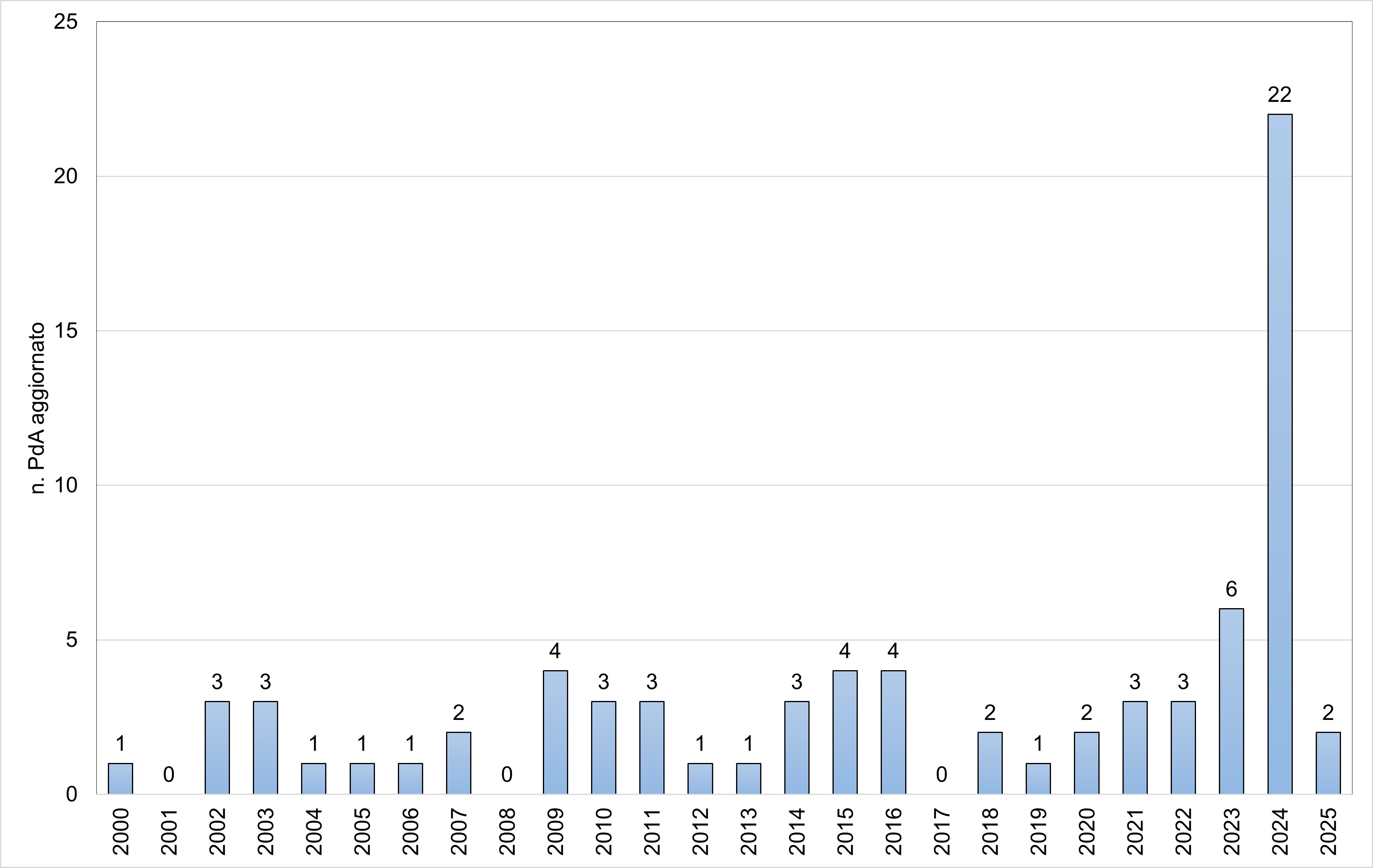
Over the last few years, the regions have been updating the legislation relating to the Integrated Water System. Consequently, the Governing Bodies of the Area proceeded with the drafting/revision/updating of the PdA, with a relative increase in the number of Plans updated annually (Figure 2).
| Allegati |
|---|
Thumbnail
Titolo
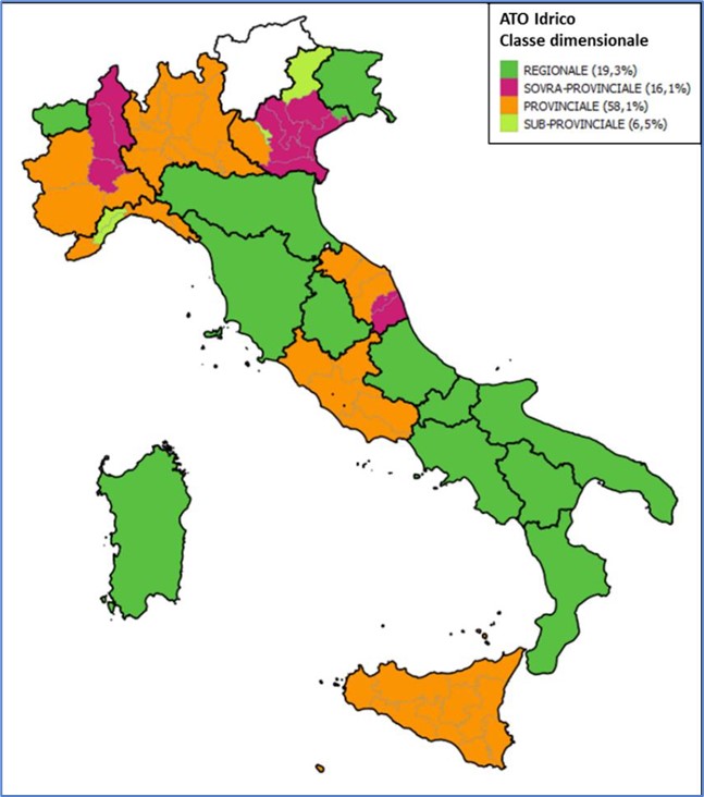
Figure 1: ATO delimitation |
Titolo
Table 1: State of progress of the Area Plans Fonte
ATO websites / Arera, Twentieth report pursuant to article 172, paragraph -bis, of legislative decree 3 April 2006, n. 152, containing "environmental regulations", 4/2/2025 |
Thumbnail
Titolo
Figure 2: Update of Area Plans Fonte
ATO websites / Arera, Twentieth report pursuant to article 172, paragraph -bis, of legislative decree 3 April 2006, n. 152, containing "environmental regulations", 4/2/2025 |
12 out of 19 regions (Abruzzo, Basilicata, Calabria, Campania, Emilia-Romagna, Friuli-Venezia Giulia, Molise, Puglia, Sardinia, Tuscany, Umbria and Valle d'Aosta) have chosen the regional extension of the ATO (Figure 1) (63%, excluding the autonomous provinces of Trento and Bolzano). However, if we compare the different size classes considering the number of ATOs, overall, it turns out that 20% of Italian areas have a regional extension.
As regards area planning, for 38 ATOs/sub ATOs there were updates to the PdA in the last six-year period 2020 - 2025 and 8 ATOs (Valle d'Aosta, Tuscany, Basilicata, Molise, Campania, Puglia, Sardinia, Calabria) of the 12 with regional extension have a single PdA (Table 1). From Figure 2, we can see how 45 APs have been updated in the last 10 years (between 2016 and 2025). In the period 2021-2024 it is noted that every year at least 3 APs are updated. There is, therefore, an increase compared to the previous period (2017-2020) in which between 0 and 2 PdA were updated in individual years. This indicates that in recent years there has been an increase in the number of updated plans, with a consequent positive impact on the assessment of the state of water resources and available infrastructure necessary to overcome any emergencies and critical issues present in the area. 2025 presents a decrease in the number of plans updated compared to the immediately preceding years. It is noted, however, that some ATOs update plans at the end of the calendar year. Consequently, the update may not yet be recorded in the indicator and, therefore, the data relating to 2025 could be underestimated. As regards the high number of PdA updated in 2024, it is noted that a good part of these pertain to regions with a single ATO divided into sub-areas, each of which has its own PdA (Emilia-Romagna, Table 1).