MARITIME SPATIAL PLANNING: MARINE AREAS AND SITES FOR AQUACULTURE
Data aggiornamento scheda: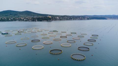
This indicator reports national scale data on the surface area and number of maritime state concession areas for aquaculture use as well as on Allocated Zones for Aquaculture (AZA). AZAs are designated by the competent authority as “Priority Areas for Aquaculture”, meaning areas free from conflicts with other uses and with environmental conditions suitable to ensure sustainable production while minimizing environmental impacts.
In Europe, identifying new marine areas for aquaculture is one of the main objectives of the Strategic Guidelines for a more sustainable and competitive EU aquaculture for 2021–2030 (COM/2021/236), of the National Strategic Aquaculture Plans 2014–2020 and 2021–2027, and of the corresponding EMFF and EMFAF Operational Programs, under Regulations 508/2014/EU and 1139/2021/EU.
The identification of AZAs is also part of the Maritime Spatial Planning (MSP) framework established by Directive 2014/89/EU, transposed into Italian law by Legislative Decree 201/2016, which supports the sustainable growth of maritime economies through a coordinated, integrated, and cross-border approach within Maritime Spatial Management Plans. These aquaculture planning processes are also relevant to climate change adaptation strategies needed to mitigate medium- and long-term sector impacts.
Italy’s maritime space, between the coastline and the 12-nautical-mile limit, covers approximately 14 million hectares. Of this area, only 20,250 hectares are currently occupied by state concessions for aquaculture use, with around 96% (19,445 ha) allocated to shellfish farming and only 3.9% (805 ha) to marine fish farming. As of April 2024, AZAs have been designated in Tuscany, Marche, Emilia-Romagna, Veneto, and Friuli-Venezia Giulia, for a total area of about 29,633 hectares. Within AZAs, 8,739 ha are occupied by shellfish farming and 665 ha by fish farming.