Emiliano Agrillo, Roberto Inghilesi, Alessandro Mercatini, Alice Pezzarossa, Nazario Tartaglione
The indicator examines the series of forest areas affected by large fires on a national, regional and protected area scale in the period between 2018 and 2025.
The distribution and extension of these surfaces generally shows significant interannual variability. 2025, in particular, was a year seriously affected by an extension of the forest areas affected by fires, greater than the previous year. Furthermore, the forest area burned is only lower than that burned in 2021, 2022 and 2023.
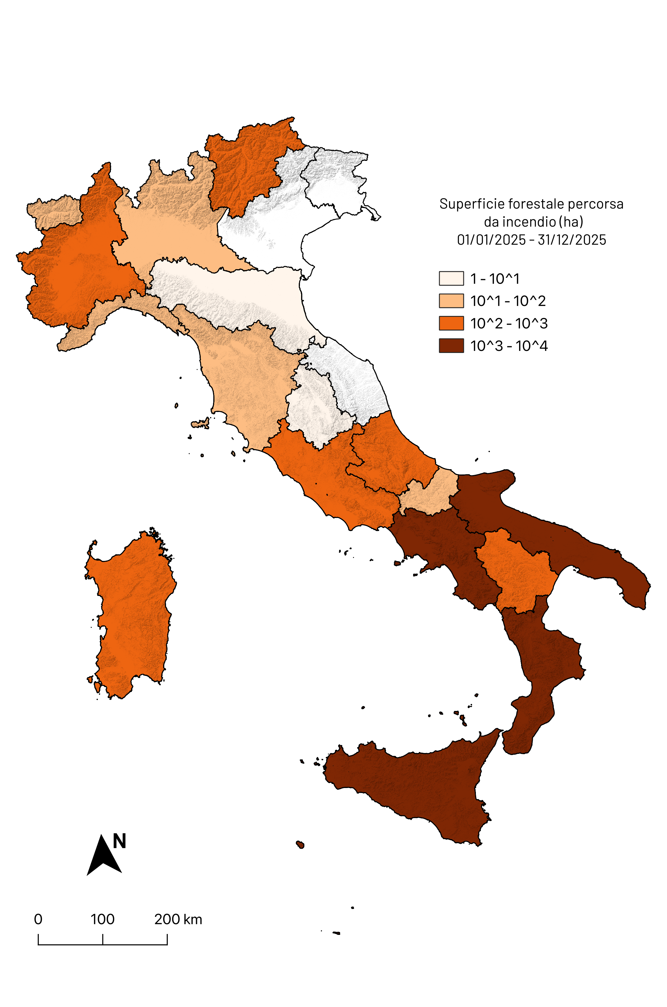
In 2025, the most affected regions were: Sicily (3,967 hectares - ha), Calabria (2,892 ha) and Campania (1,835 ha), which together represent 71% of the forest area at national level affected by fire.
The forest classes most affected are evergreen broad-leaved trees (e. g. Holm oak forests and tall scrub), followed by deciduous broad-leaved trees (e. g. Oak and beech forests) and decidedly less so by conifers (e. g. Pine forests, fir forests and larch forests).
The linear regression analysis of the national forest cover data series affected by fire does not show an increasing trend, although the length of the series does not allow medium and long-term evaluations. On the contrary, a statistically significant positive trend was observed for the regions of Puglia, Basilicata and Calabria.
The indicator (relating to status and changes) shows the extension of forest surfaces affected annually by large forest fires starting from 1 January 2018. The data is disaggregated by forest type and by territorial administrative level: national, regional and protected natural areas.
The indicator is built on the processing of data provided by the European Forest Fire Information System (EFFIS). Since 2018, thanks to the new generation of MSI multispectral sensors hosted on the Sentinel-2 satellite, EFFIS has been able to detect fires with a minimum size of 1 hectare, achieving an accuracy in the identification of fire areas at European level close to 95%. To evaluate the impact of fires on the different types of forest cover, the information on pre-existing forest cover obtained from ISPRA based on machine-learning classification models (Ecosystem Classification Model -Forest 4 ECM-F4 product) is superimposed on the perimeter of the burned areas provided by EFFIS. The classes referable to forest covers can be attributed to the EUNIS nomenclature ( European Nature Information System ) (last update 2021) at levels II and III: T1-deciduous broad-leaved forests (e. g. Oak and beech forests); T2-evergreen broad-leaved forests (e. g. Holm oaks and tall scrub); T3-coniferous forests (e. g. Fir and pine forests and plantations); T34-sub-alpine temperate forests (e. g. Larch forests). Forests not classified by the ECM-F4 model with the code TNC (class relating to non-classified forest areas) are also considered.
Provide useful information to evaluate the health status of forest ecosystems following the main disturbances caused by extensive forest fires in terms of affected surfaces.
Law 21 November 2000, n. 353 (Framework law on forest fires)
Law n.155 of 08.11.21, having as its first article the "Urgent measures for strengthening coordination, technological updating and increasing operational capacity in forecasting, prevention and active fight against forest fires".
DM (MASE) n. 84.2025 - General directive concerning the performance of the functions and tasks falling under ISPRA for the three-year period 2025-2027 (see Art. 2 Priority lines of support action for the Ministry of the Environment and Energy Security, XI. Geographic information systems and cartography for environmental protection, point b)
SNPA Council Resolution. Meeting of 18.05.2021 (Doc. No. 108/21 - Operation, areas of intervention and mapping of specialist skills in the management of environmental emergencies of the SNPA)
Agrillo E, Filipponi F, Pezzarossa A, Casella L, Smiraglia D, Orasi A, Attorre F, Taramelli A. (2021). Earth Observation and Biodiversity Big Data for Forest Habitat Types Classification and Mapping. Remote Sensing. 2021; 13(7):123.
E. Agrillo, F. Filipponi, R. Inghilesi, A. Mercatini, and A. Pezzarossa. Monitoring of changes in forest ecosystems in Italy. ISPRA Technical report, 2022. (https://groupware. sinanet. isprambiente. it/prodotti-operativi-di-sorveglianza-ambientale/library/ecosystems-classification-model/monitoraggio_cambiamenti_ecosistemi_forestali_-italia_ispra_2021/download/en/1/Monitoraggio_cambiamenti_ecosistemi_forestali_%20Italia_ISPRA_2021_signed. pdf? action=view)
Barbosa, P., Kucera, J., Strobl, P., Vogt, P., Camia, A., & San-Miguel-Ayanz, J. S. (2006). European Forest Fire Information System (EFFIS) Rapid damage assessment: Appraisal of burnt area maps in southern Europe using MODIS data (2003-2005). Forest Ecology and Management, 234(1), S218.
Barredo, J. I., Brailescu, C., Teller, A., Sabatini, F. M., Mauri, A., & Janouskova, K. (2021). Mapping and assessment of primary and old-growth forests in Europe. Publications Office of the European Union, Luxembourg.
Blasi, C., Bovio, G., Corona, P. M., Marchetti, M., & Maturani, A. (2004). Fires and ecosystem complexity. From forest planning to environmental recovery. Https://www. mite. gov. it/sites/default/files/archivio/allegati/aib/incendi_e_complessita_ecosistemica. pdf
Cervellini, M., Zannini, P., Di Musciano, M., Fattorini, S., Jiménez-Alfaro, B., Rocchini, D.,... & Chiarucci, A. (2020). A grid-based map for the Biogeographical Regions of Europe. Biodiversity Data Journal, 8.
Chytrý, M. & co-authors (2020). EUNIS Habitat Classification: Expert system, characteristic species combinations and distribution maps of European habitats. Applied Vegetation Science, volume 23, issue 4, pp 648-675
Sedano, F., Maianti, P., Boca, R., Suarez-Moreno, M., Broglia, M. Et al., Advance report on Forest Fires in Europe, Middle East and North Africa 2025, Publications Office of the European Union, Luxembourg, 2026, https://data. europa. eu/doi/10.2760/3859043, JRC146199
Schaminée, J. H. J., Chytrý, M., Hennekens, S. M., Janssen, J. A. M., Knollová, I., Marceno, C., Tichý, L. & data providers (2020). Support to EUNIS habitat classification revision IV. Report for the EEA - Framework Contract: EEA/NSS/17/002/Lot 1, specific contract No 3417/B2019/EEA6
National Inventory of Forests and Forest Carbon Reservoirs, 2015
https://www. mase. gov. it/pagina/editore-editore-delle-aree-naturali-protette-0
https://www. mase. gov. it/pagina/rete-natura-2000
https://ec. europa. eu/environment/nature/natura2000/biogeog_regions/
The data underlying the following indicator may differ from those of other national databases such as that of the Carabinieri Forest Protection Command - Forest Fire Information Unit, especially with regard to small fires. In satellite products derived from models there may be omissions in detecting the areas affected by fire determined, for example, by excessive cloud cover, by the size and duration of the fire, by the type of fire event (e. g. Crown or undergrowth fire), by the lack of coincidence between the event and the passage into orbit of the satellite and by the structural physiognomic nature of the ecosystem involved in the event.
To improve the information relating to the national forest and woodland covers involved, in the future a EUNIS legend will be applied to greater thematic detail in all the categories currently present in the indicator.
For a complete assessment of the impact of fires on the health of the tree-shrub covers affected, in addition to estimating the surface area affected by the fire, it would be useful to obtain data relating to the loss of biomass and the recovery capacity of the natural covers impacted by the fires and the effects of each individual event on the covers affected.
In the future, thanks to the availability of new products developed within the European Earth observation system Copernicus Land Monitoring Service (CLMS), it will be possible to analyze the phenomenon of forest fires in more detail, carrying out high resolution spatio-temporal assessments and improving the understanding of the dynamics of occurrence, propagation and impact of the events on the territory.
EEA (European Environmental Agency)
ISPRA (Higher Institute for Environmental Protection and Research)
Istat (National Institute of Statistics)
JRC (Joint Research Centre)
MASE (Ministry of the Environment and Energy Safety)
MiTE (Ministry of Ecological Transition)
The data relating to the areas affected by fire can be freely downloaded at the link: https://effis. jrc. ec. europa. eu/applications/data-and-services .
Data relating to the national distribution of burned areas relating to the main forestry categories are available at the link: https://groupware. sinanet. isprambiente. it/prodotti-operativi-di-sorveglianza-ambientale/library/disturbance-agents/wildfires/burnt-areas-italian-terrestrial-ecosystem
The data relating to the national distribution of forest categories (Ecosystems Classification Model Forest4 ECM-F4) are available at the link: https://groupware. sinanet. isprambiente. it/prodotti-operativi-di-sorveglianza-ambientale/library/ecosystems-classification-model
The data relating to the EUNIS legend version 2021 is available at the link:
https://www. eea. europa. eu/data-and-maps/data/eunis-habitat-classification-1
The data relating to the territorial administrative units can be accessed from the Istat portal at the link:
https://www. istat. it/it/archivio/222527
The data relating to protected areas can be accessed from the EEA portal at the links:
https://www. eea. europa. eu/data-and-maps/data/nationally-designated-areas-national-cdda-17
https://www. eea. europa. eu/data-and-maps/data/natura-13
The data relating to the Ramsar areas can be accessed from the national geoportal at the link:
http://wms. pcn. minambiente. it/ogc? map=/ms_ogc/wfs/RAMSAR. map
The data relating to the biogeographical regions can be accessed at the link:
National, Regional
2018-2025
national, regional and protected natural areas levels were analyzed with standard statistical methods (average and linear regression), to evaluate both the existence of trends and the variability and general characteristics of the phenomenon at different spatial scales.
From the analysis of the time series of forest surfaces affected by fire starting from 2018, 2021 emerges as an anomalous value (outlier) for the extension of impacted forest surfaces. For this reason, in the indicator presented here, 2021 is excluded from the statistical analyzes carried out for the trend analysis. From the examination of the series, the stochastic component of the phenomenon emerges, which conditions the analysis. We therefore attempted to first verify the significance of the results with regards to the trends. In cases where the presence of a significant trend was not found, the assessment of the state of the system was discussed in terms of comparison of the current value of the indicator with the average value in the period considered.
The methodology used to build the indicator starting from 2018 is based on the evaluation of the surfaces affected by fire, distinguishing the different classes of forest ecosystems present. To obtain a quantitative evaluation of the burned forest covers, the polygons corresponding to the burned areas identified by EFFIS were considered together with the distributions of the forest categories obtained from the ECM-F4 forest ecosystem classification system created by ISPRA. These forest classes were defined following the EUNIS nomenclature (European Nature Information System - last update 2021) at level II and III: T1-deciduous broad-leaved forests (e. g. Oak and beech forests); T2-evergreen broad-leaved forests (e. g. Holm oaks and tall scrub); T3-coniferous forests (e. g. Fir forests, pine forests and plantations); T34-sub-alpine temperate forests (e. g. Larch forests). Forests not classified by the ECM-F4 model with the code TNC (class relating to non-classified forest areas) are also considered. The EFFIS polygons, together with the other spatialized datasets used, were reprojected into a single decimal metric coordinate system, in order to calculate statistics relating to the different themes. The annual values of the total surface area affected by fires in the various classes were calculated at a national and regional scale, in the protected natural areas of the EUAP network (Official List of Protected Areas) established by resolution of the State-Regions Conference of 17 December 2009 (National Parks; Regional Parks; State Reserves; Regional Reserves) and in the sites belonging to the Natura 2000 network: Special Conservation Areas (SAC) and Protection Zones Special (SPA)). Furthermore, the effects of forest fires were also considered in humid areas under the Ramsar Convention, and in biogeographical regions (Alpine, continental and Mediterranean). With specific geometric-spatial analysis tools on the QGIS platform it was possible to calculate the surface area of each forest class mapped by the ECM-F4 product for the identified intersection areas. The spatial-statistical calculations were carried out with the aid of R, Python and QGis software. For protected natural areas, estimates of burned surfaces were carried out separately within the individual typologies. In fact, as is known, there are overlaps in the founding boundaries due to different administrative acts underlying the definition of the EUAP network and the Natura 2000 network, with consequent planimetric intersections both within the individual categories of the networks and between the two systems. In this case the EFFIS polygons of the areas affected by fire were intersected ( overlay thematic) with the polygons of the different themes considered and the union of all the areas belonging to the same typology was then evaluated in order to avoid counting the same surface twice.
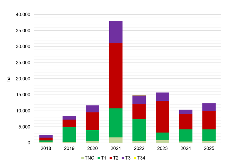
At a national level, in the period between 2018 and 2025, the average value of the forest area affected by fire was equal to 10,827 ha.
In 2025 the value, 12,306 ha, is higher than both the average and that of 2024 (+19%), justifying the attribution of a poor status (Figure 1).
At a regional level, in Valle d'Aosta, Trentino-Alto-Adige, Lazio, Abruzzo, Molise, Campania, Puglia, Basilicata, Calabria and Sardinia the 2025 value exceeds the average value of the period considered.
As regards the different categories of protected areas, the value of forest surface affected by fire in 2025 exceeds the average value of the historical series considered for: National Parks, State Nature Reserves, Regional Nature Reserves, Other Protected Natural Areas, SACs, SPAs and Ramsar Areas.
The linear regression analysis of the national forest cover data series affected by fire for the years 2018, 2019, 2020, 2022, 2023, 2024 and 2025 does not show a significant trend.
The increase in the national surface affected by fire compared to the previous year is clearly visible in Figure 1, as is the exceptional relevance of 2021. At a regional level, the trend presents significant differences in the evaluation of the trend.
A statistically significant increasing trend was calculated for the regions of Basilicata, Calabria, and Puglia; Ramsar Areas stand out among the categories of protected areas.
However, the analyzes of the trends observed in the remaining Italian regions and in all the other categories of protected areas considered by the indicator were of little statistical significance.
| Allegati |
|---|
Titolo
Table 1: Areas of the main forest categories affected by fire at the regional level Fonte
ISPRA analysis based on data from ISPRA and the JRC Legenda
TNC: Burned area of unclassified forests; T1: Burned area of deciduous broadleaf forests; T2: Burned area of evergreen broadleaf forests; T3: Burned area of coniferous forests; T34: Burned area of subalpine temperate forests; TOT: Sum of TCN, T1, T2, T3, and T34. |
Titolo
Table 2: Areas of the main forest categories affected by fire in the various categories of protected areas (2018) Fonte
ISPRA analysis based on data from ISPRA and the JRC Legenda
TNC: Burned area of unclassified forests; T1: Burned area of deciduous broadleaf forests; T2: Burned area of evergreen broadleaf forests; T3: Burned area of coniferous forests; T34: Burned area of subalpine temperate forests; TOT: Sum of TCN, T1, T2, T3, and T34. Note
The calculations for individual categories of protected areas are performed without taking into account overlaps between them. Therefore, it is possible to sum the figures within each category but not across categories; otherwise, there is a risk of overestimating the burned areas, particularly between the EUAP categories and those of the Natura 2000 Network. |
Titolo
Table 3: Areas of the main forest categories affected by fire in the various categories of protected areas (2019) Fonte
ISPRA analysis based on data from ISPRA and the JRC Legenda
TNC: Burned area of unclassified forests; T1: Burned area of deciduous broadleaf forests; T2: Burned area of evergreen broadleaf forests; T3: Burned area of coniferous forests; T34: Burned area of subalpine temperate forests; TOT: Sum of TCN, T1, T2, T3, and T34. Note
The calculations for individual categories of protected areas are performed without taking into account overlaps between them. Therefore, it is possible to sum the figures within each category but not across categories; otherwise, there is a risk of overestimating the burned areas, particularly between the EUAP categories and those of the Natura 2000 Network. |
Titolo
Table 4: Areas of the main forest categories affected by fire in the various categories of protected areas (2020) Fonte
ISPRA analysis based on data from ISPRA and the JRC Legenda
TNC: Burned area of unclassified forests; T1: Burned area of deciduous broadleaf forests; T2: Burned area of evergreen broadleaf forests; T3: Burned area of coniferous forests; T34: Burned area of subalpine temperate forests; TOT: Sum of TCN, T1, T2, T3, and T34. Note
The calculations for individual categories of protected areas are performed without taking into account overlaps between them. Therefore, it is possible to sum the figures within each category but not across categories; otherwise, there is a risk of overestimating the burned areas, particularly between the EUAP categories and those of the Natura 2000 Network. |
Titolo
Table 5: Areas of the main forest categories affected by fire in the various categories of protected areas (2021) Fonte
ISPRA analysis based on data from ISPRA and the JRC Legenda
TNC: Burned area of unclassified forests; T1: Burned area of deciduous broadleaf forests; T2: Burned area of evergreen broadleaf forests; T3: Burned area of coniferous forests; T34: Burned area of subalpine temperate forests; TOT: Sum of TCN, T1, T2, T3, and T34. Note
The calculations for individual categories of protected areas are performed without taking into account overlaps between them. Therefore, it is possible to sum the figures within each category but not across categories; otherwise, there is a risk of overestimating the burned areas, particularly between the EUAP categories and those of the Natura 2000 Network. |
Titolo
Table 6: Areas of the main forest categories affected by fire in the various categories of protected areas (2022) Fonte
ISPRA analysis based on data from ISPRA and the JRC Legenda
TNC: Burned area of unclassified forests; T1: Burned area of deciduous broadleaf forests; T2: Burned area of evergreen broadleaf forests; T3: Burned area of coniferous forests; T34: Burned area of temperate subalpine forests Note
The calculations for individual categories of protected areas are performed without taking into account overlaps between them. Therefore, it is possible to sum the figures within each category but not across categories; otherwise, there is a risk of overestimating the burned areas, particularly between the EUAP categories and those of the Natura 2000 Network. |
Titolo
Table 7: Areas of the main forest categories affected by fire in the various categories of protected areas (2023) Fonte
ISPRA analysis based on data from ISPRA and the JRC Legenda
TNC: Burned area of unclassified forests; T1: Burned area of deciduous broadleaf forests; T2: Burned area of evergreen broadleaf forests; T3: Burned area of coniferous forests; T34: Burned area of temperate subalpine forests Note
The calculations for individual categories of protected areas are performed without taking into account overlaps between them. Therefore, it is possible to sum the figures within each category but not across categories; otherwise, there is a risk of overestimating the burned areas, particularly between the EUAP categories and those of the Natura 2000 Network. |
Titolo
Table 8: Areas of the main forest categories affected by fire in the various categories of protected areas (2024) Fonte
ISPRA analysis based on data from ISPRA and the JRC Legenda
TNC: Burned area of unclassified forests; T1: Burned area of deciduous broadleaf forests; T2: Burned area of evergreen broadleaf forests; T3: Burned area of coniferous forests; T34: Burned area of temperate subalpine forests Note
The calculations for individual categories of protected areas are performed without taking into account overlaps between them. Therefore, it is possible to sum the figures within each category but not across categories; otherwise, there is a risk of overestimating the burned areas, particularly between the EUAP categories and those of the Natura 2000 Network. |
Titolo
Table 9: Areas of the main forest categories affected by fire in the various categories of protected areas (2025) Fonte
ISPRA analysis based on data from ISPRA and the JRC Legenda
TNC: Burned area of unclassified forests; T1: Burned area of deciduous broadleaf forests; T2: Burned area of evergreen broadleaf forests; T3: Burned area of coniferous forests; T34: Burned area of temperate subalpine forests Note
The calculations for individual categories of protected areas are performed without taking into account overlaps between them. Therefore, it is possible to sum the figures within each category but not across categories; otherwise, there is a risk of overestimating the burned areas, particularly between the EUAP categories and those of the Natura 2000 Network. |
Thumbnail
Titolo
Figure 1: Areas of the main forest categories affected by wildfires nationwide Fonte
ISPRA analysis based on ISPRA and JRC data Legenda
TNC: unclassified forests; T1: deciduous broadleaf forests; T2: evergreen broadleaf forests; T3: coniferous forests; T34: temperate subalpine forests. |
Thumbnail
Titolo
Figure 2: Regional forest area affected by fire (2025) Fonte
ISPRA analysis based on data from ISPRA and the JRC
|
Thumbnail
Titolo
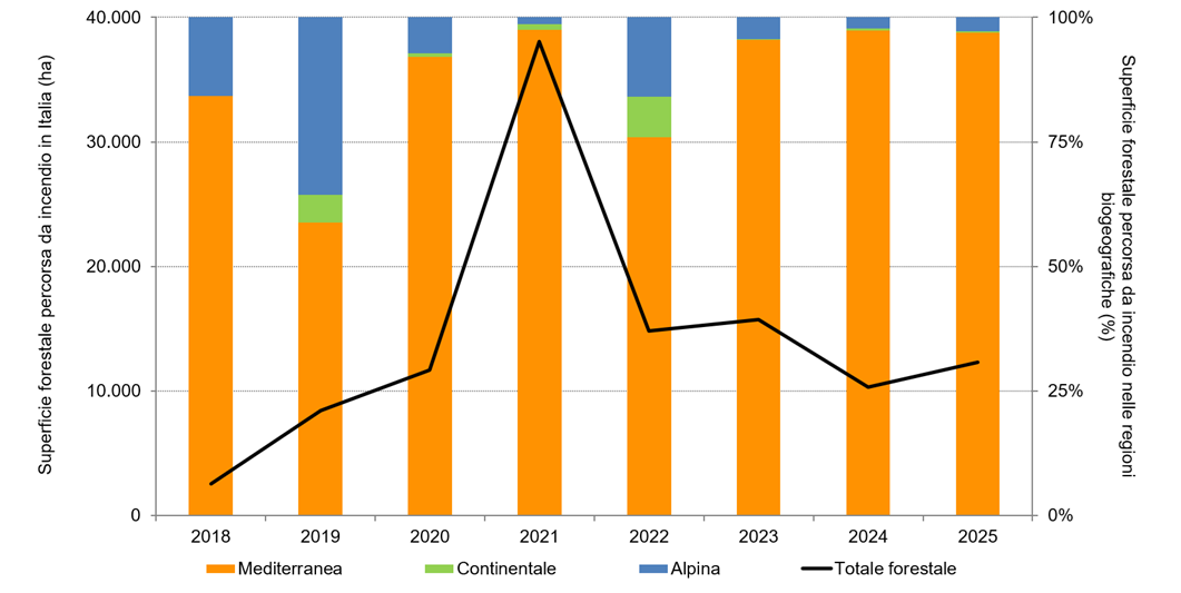
Figure 3: National forest area affected by wildfires, by biogeographic region Fonte
ISPRA analysis based on data from ISPRA and the JRC Legenda
Forest area affected by fire, broken down by biogeographic region as a percentage (histogram bars), and forest area affected by fire in Italy in hectares (black line). |
Thumbnail
Titolo
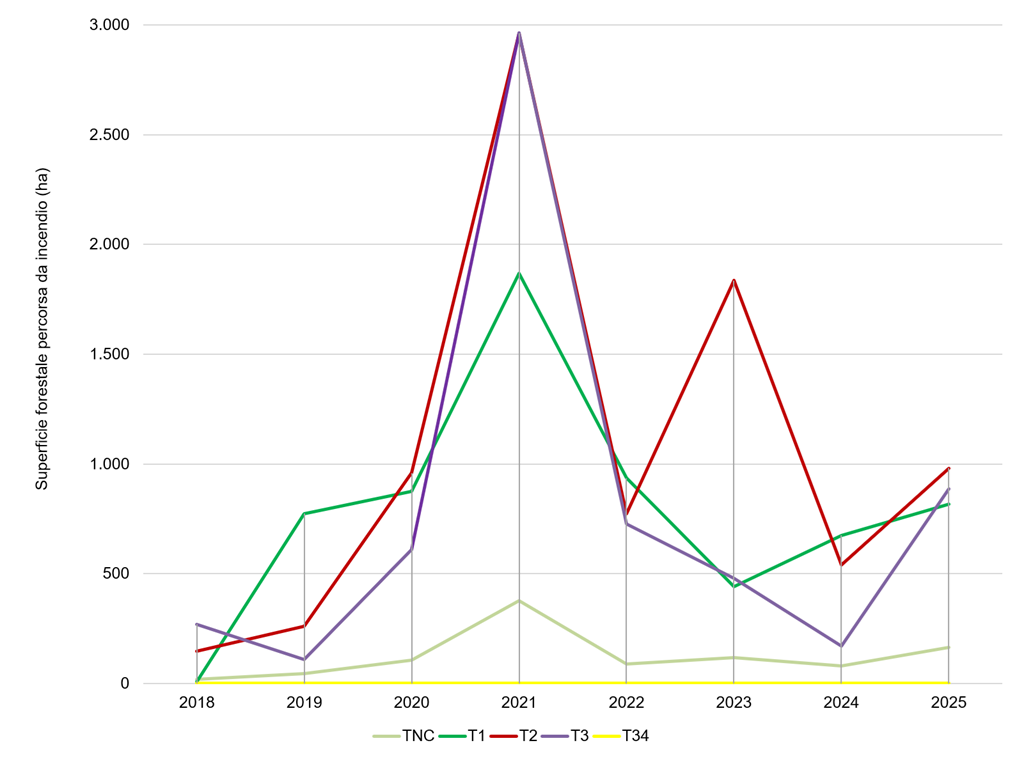
Figure 4: National area of the main forest categories affected by fires in protected natural areas (EUAP) Fonte
ISPRA analysis based on data from ISPRA and the JRC Legenda
TNC: unclassified forests; T1: deciduous broadleaf forests; T2: evergreen broadleaf forests; T3: coniferous forests; T34: temperate subalpine forests Note
The EUAPs considered here refer to the official list of protected areas; see the Resolution of the State-Regions Conference of December 17, 2009. Only terrestrial EUAPs were considered. |
The fires that occurred in Italy in 2025 had a greater impact than the previous year, affecting a larger extent of forest areas.
The total surface area burned in Italy in 2025 is higher than that burned in 2018, 2019, 2020 and 2024 (Figure 1). From 2018 to 2025, the forest category most impacted at a national level is that of evergreen broad-leaved trees (T2 - mainly holm oaks and tall scrub); then followed by deciduous broadleaf trees (T1 – mainly oak forests) and conifers (T3 – mainly pine forests) in second and third place. The result does not correspond to the estimates of relative abundance of forest covers on the national territory, which see deciduous broad-leaved forests as the most widespread in Italy (National Inventory of Forests and Forest Carbon Reservoirs 2015).
The region with the highest growth trend is Calabria with 479 ha per year.
Basilicata is the region with the lowest growth trend, with a value of approximately 83 ha per year.
As shown in Figure 2, the regions with the largest forest area affected by fire in 2025 are Sicily (3,967 ha), Calabria (2,892 ha), Campania (1,835 ha) and Puglia (1,050). These four regions together, in fact, make up almost 80% of the total national forestry capital that caught fire. In Sicily, it was mainly evergreen broad-leaved forests (T2) that caught fire, mainly consisting of holm oaks and high scrub. For the other three regions, however, it was mainly the deciduous broad-leaved trees (T1) that caught fire, consisting in the aforementioned regions of mixed forests and oak forests.
Veneto, Friuli-Venezia Giulia and Marche have no burned surfaces in 2025 (Table 1).
As can be seen from Figure 3, in the period considered, the biogeographical region with the largest forest area affected by fire is the Mediterranean one. The largest burned forest area in the Alpine biogeographic region is observed in 2019, while for the continental biogeographic region in 2022. In 2025, 97% of forest areas affected by fire are located in the Mediterranean biogeographic region.
As regards the national system of protected areas, from the analysis of the historical series (Tables 2-9), even in 2025 the Special Conservation Areas are the category with the largest wooded area affected by fire.