Elisa Brustia, Gianluigi Di Paola, Carla Iadanza, Paolo Primerano, Alessandro Trigila
The indicator provides information on the main landslide events that caused fatalities, injuries, evacuations, and damage to buildings, cultural heritage assets, primary linear communication infrastructures, and service networks across the national territory over the past year. In 2024, there were 185 major landslide events, resulting in 5 deaths, 18 injuries, and predominantly causing damage to the road network and buildings.
The indicator provides information on the main landslide events that have occurred on the national territory in the last year. Major landslide events are defined as those which caused deaths/missing people, injuries, evacuees and damage to buildings, cultural assets, primary linear communication infrastructures and service infrastructures/networks. A main landslide event can also refer to multiple landslides triggered in a given area, in a given time interval (generally within 24 hours) and caused by the same triggering factor (rainfall event, earthquake). The parameters collected are: the date of the event, the location of the landslide (locality, municipality, province, region), the description and the damage. The data is taken from technical reports drawn up by ISPRA, regions and autonomous provinces, ARPA, Civil Protection, Functional Centres, CNR, local authorities, from Autostrade, ANAS and FS press releases and from news sources. From 2010 to 2020, in previous releases of the database and in related publications, the indicator appears with the name "Landslide events".
Provide a picture of the main landslide events that have occurred in the last year on the national territory following meteorological-pluviometric, seismic or anthropogenic causes.
Collection, processing, archiving and dissemination of data regarding soil protection and hydrogeological instability referring to the entire national territory (articles 55 and 60 of Legislative Decree 152/2006 “Regulations on environmental matters”); update of the Inventory of Landslide Phenomena in Italy (art. 6, paragraph 1 letter g of Law 132/2016).
ISPRA - Trigila A., Lastoria B., Iadanza C., Bussettini M., Mariani S., D'Ascola F., Salmeri A., Cassese M. L., Pesarino V., Di Paola G., Romeo S., Rischia I., Dessì B., Spizzichino D., Licata V., Gallozzi P. L. (2025) Hydrogeological instability in Italy: hazards and risk indicators - 2024 Edition. Reports 415/2025.
The indicator reports only the main landslide events on the national territory that caused damage to people, buildings, cultural heritage, primary communication infrastructures and service infrastructures/networks.
-
ARPA/APPA (Regional and Autonomous Province Agencies for Environmental Protection)
CNR
Infrastructure management bodies
ISPRA
Civil Protection
Autonomous Provinces
Regions
Internet sites
Event reports on the websites of autonomous regions and provinces, ARPA, Civil Protection, Functional Centres, CNR, local authorities; Press releases on the Autostrade, ANAS and FS websites; Online news sources.
National, regional, provincial, municipal
2010-2024
For each year, the sum of the dead/missing and injured was calculated and the types of damage (to buildings, cultural heritage, primary linear communication infrastructures and service infrastructures/networks) produced by the main landslide events that occurred on the national territory were identified. If the source only reports the number of evacuated families, the number of evacuated people was obtained using a coefficient equal to 2.3 members per family.
In 2024, the main landslide events totalled 185, causing 5 deaths, 18 injuries, and predominantly damaging the road network and buildings.
Fluctuations in the yearly number of major recorded landslide events from 2010 to 2024 are linked to annual precipitation patterns, the occurrence of significant seismic events, and the previously mentioned inconsistencies in baseline data and data-collection methods. At present, it is not possible to assess a trend for the indicator due to the limited length of the available historical series and the partial heterogeneity of the underlying data and acquisition methods.
| Allegati |
|---|
Titolo
Table 1: Major landslide events in 2024 Fonte
ISPRA processing based on data from SNPA, Regions, Autonomous Provinces, Civil Protection, CNR, Infrastructure Managing Authorities, and websites Note
For the Autonomous Province of Bolzano, data are derived from systematic field surveys conducted by the Province’s technical offices. |
Thumbnail
Titolo
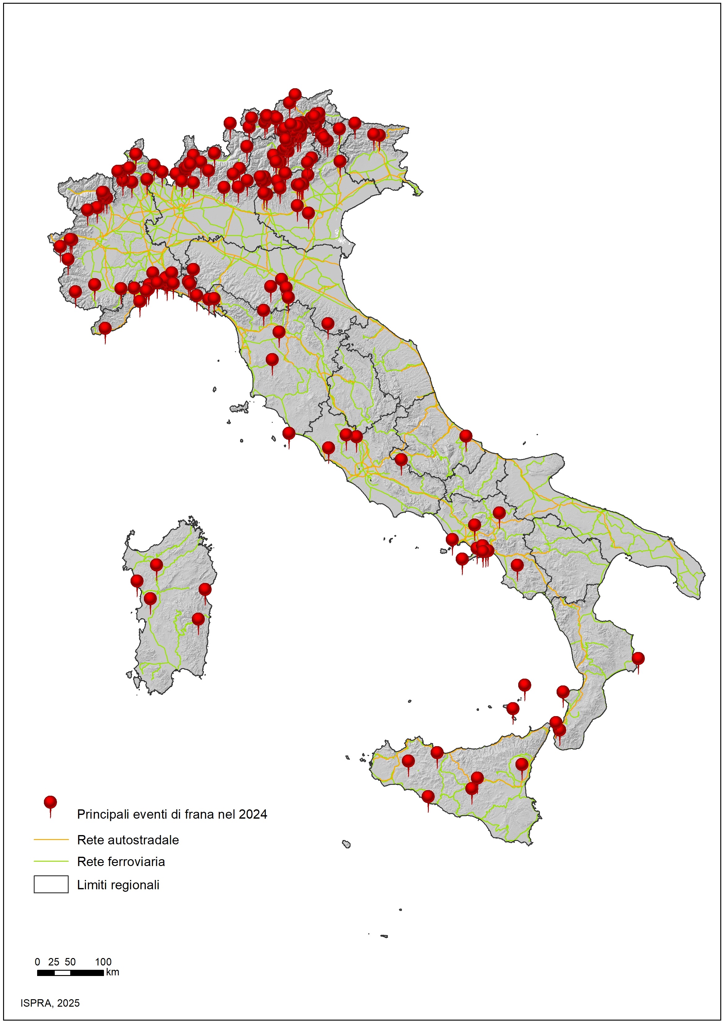
Figure 1: Main landslide events between January and December 2024 Fonte
ISPRA |
Thumbnail
Titolo
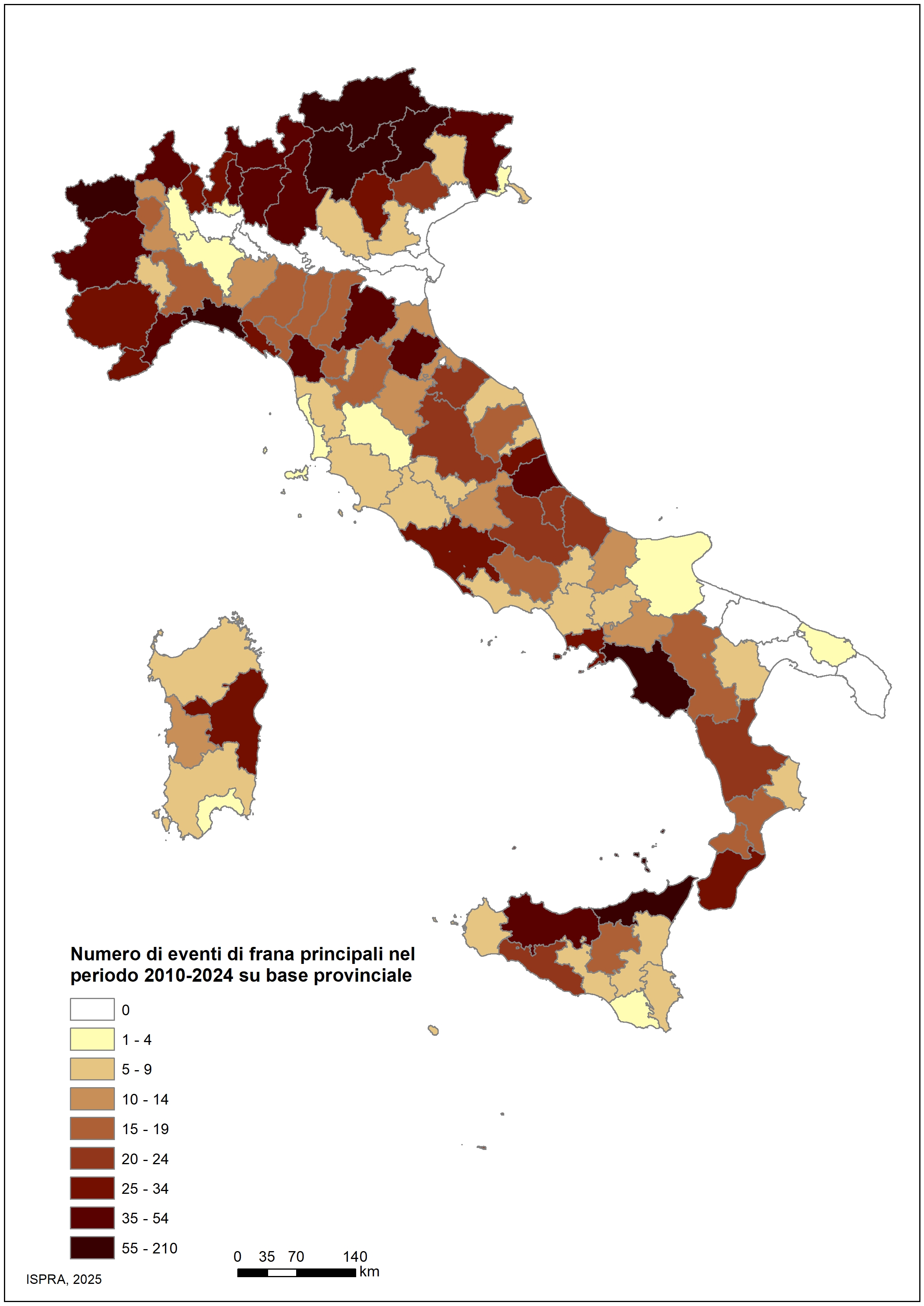
Figure 2: Number of major landslide events in the period 2010–2024 by province Fonte
ISPRA |
Between January and December 2024, 185 major landslide events occurred, causing 5 deaths, 18 injuries, and predominantly damaging the road network and buildings (Figure 1 and Table 1). Major landslide events are distributed across much of the Italian territory, particularly in the Autonomous Province of Bolzano and in the regions of Lombardy, Piedmont, Liguria, Veneto, and the Autonomous Province of Trento.
Among the main landslide events in 2024 are:
Between 2010 and 2024, the provinces most affected by major landslide events were Bolzano, Genoa, Salerno, Trento, Belluno, Messina, and Aosta, each with more than 55 major events (Figure 2).
As for the economic quantification of damages caused by landslides and the allocated resources, only aggregated flood + landslide data are generally available (see Environmental Indicators Database – Flood Events), making it impossible to derive figures for individual landslide events or annual totals.